Issues are under construction………………
8.2. Process of developing an Early Warning (Sample case of Mongolia) :
The Multi-hazard Early Warning Center (MHEWC) has the capacity to deploy low-cost, easy-to-maintain nowcasting services that enable real-time interpretation of up-to-date time-series weather-parameter sensor data, ingested instantly from meteorological stations.
8.2 Process of Developing an Early Warning System (Sample Case: Mongolia)
Reviewing the diagram below, the likelihood of rapid-onset multi-hazard events particularly floods occurring within a stressed and short timespan—is evident. This strongly indicates that Mongolia needs to shift from traditional forecasting toward a modern, real-time, multi-hazard early warning system capable of issuing timely alerts to frontline, climate-vulnerable communities such as herders, farmers, and other at-risk populations.
A robust implementation of integrated Impact-Based Forecasting (IBF) and multi-hazard early warning provides a substantive solution to Mongolia’s challenges in predicting hazardous weather. In practice, an IBF system is typically integrated with an autonomous, ICT-driven, automated multi-hazard warning workflow.
Step 1: Initiate Impact Forecasting
The process begins by anchoring the impact forecast using a defined lead time, which establishes the operational forecasting window for potential impacts.
Step 2: Strengthen Hybrid Observation and Real-Time Screening
The second step is to establish a strong hybrid observation system (see figure above) to continuously monitor prevailing and evolving weather conditions. This enables real-time screening of whether conditions are likely to transition into multi-hazard scenarios.
Once critical weather conditions are detected through real-time, spatiotemporal observation, the system should generate emergency hazard warnings and advisories to inform the humanitarian program cycle about the appropriate level of preparedness and response that needs to be mobilized.
Step 3: Trigger Automated Early Warning and Decision Support
In the third step, the IBF system should programmatically trigger early warnings through ICT-enabled processes, including map-based visualization that:
identifies locations where loss and damage (L&D) are occurring, and
highlights additional hotspots where potential L&D is likely to occur.
This step should also provide advisories on early actions, contingency planning, and response mobilization, based on forecast outputs and warning thresholds.
Critical Requirement: Common Alerting for Sudden-Onset Events
A primary responsibility of the IBF system is to issue timely forecasts and warnings to protect lives and property, especially when conditions rapidly intensify. For example, when convective rainfall is likely to develop suddenly and trigger flash flooding that may cause L&D, a common alerting and warning mechanism becomes essential.
Because such weather events can evolve rapidly, the CAP-based warning system must be fully automated and operational through ICT programs (e.g., CAP scripting using Python or Java) and should integrate complementary dissemination tools such as Google Public Alerts as part of an end-to-end warning process.
.
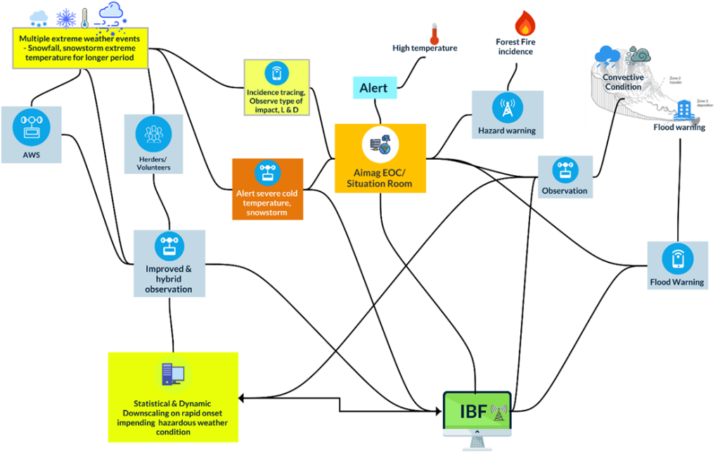
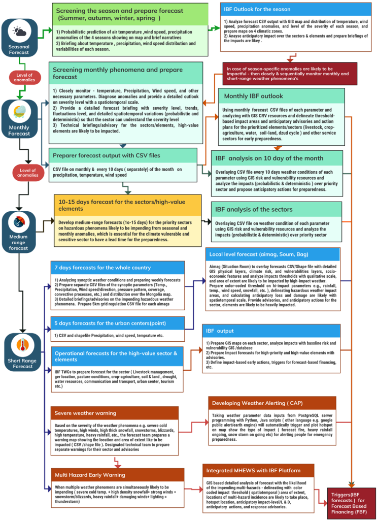
Figure 22 : Nowcasting, hourly, daily IBF production process and issuing a multi-hazard early warning ( Source: Z M Sajjadul Islam, Team Leader of IBF & FBF Methodology, tools, guidelines development for UNDP-GCF, Mongolia) :
- Crowdsourced observation :
Crowdsourced observation can play a significant role as an informal extension of the surface observation network. This can be operationalized by equipping volunteers and local actors with basic weather-parameter instruments such as thermometers, handheld anemometers, and modular handheld rain/snow gauges and installing these at strategically important locations, including tourist resorts, community houses, office buildings along riversides (lower floodplain areas), permanent settlements in hard-to-reach areas, logistics transport routes, herder communities, livestock and agriculture offices, forest ranger posts, local government offices, and fixed infrastructure such as telephone/cell towers.
In parallel, volunteer groups can be mandated to submit weather and hazard-incidence information through Android applications directly to the IBF server. In many situations, comprehensive ground-level observations are essential to understand the type and severity of impacts and loss and damage (L&D) occurring on the ground, assess whether impending extreme weather may escalate into multi-hazards (e.g., severe cold temperatures and winter storms), document induced impacts, and estimate persistence and dissipation timeframes.
The crowdsourced network should therefore be used to capture near-real-time incident reports and evolving scenarios, including the trail of damage, the geographic extent of affected areas, the magnitude and intensity of hazardous conditions, and the resulting impacts on livelihoods and exposed elements.
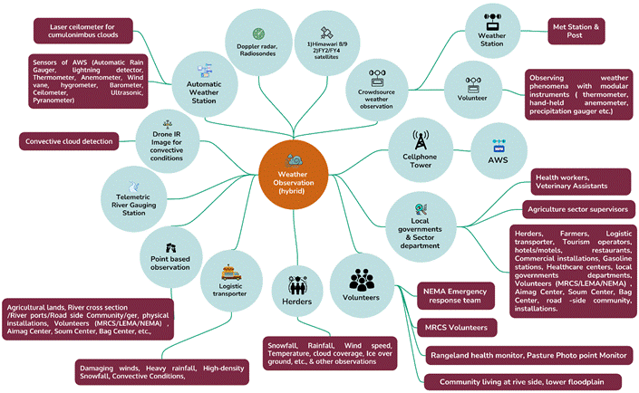
Figure 9 : Proposed hybrid – high-density, nested, and crowdsource-based surface weather observation and incidence monitoring system(Source: Z M Sajjadul Islam, UNDP-GCF)
Beyond observation, crowdsourcing can also function as a strong communication and situational-awareness mechanism through social journalism, enabling wider coverage of local conditions to inform NMHSs about the scale, intensity, frequency, and spatial patterns of impacts and L&D, supported by facts and figures. This volunteered social-observation process can help track evolving situations and provide inputs for real-time early warning and alerting throughout the entire lifecycle of extreme and hazardous events capturing observations, incident reports, and L&D scenarios across broad geographic areas.
The IBF Technical Working Group (TWG) should organize the crowdsourced observation teams, conduct orientations, and provide the required applications and tools to enable structured information feeds. The table below illustrates the ICT tools and processes of the IBF system, including open-source and interactive mechanisms for information access and sharing..
Montenegro – Developing the RoadMap for the development of the National Nowcasting (NWC)
Technical Proposal for UNDP
Developing the Roadmap for the development of the National Nowcasting (NWC) System for the Institute for Hydrometeorology and Seismology of Montenegro (Technical Proposal for conducting the Assessment)
- Introduction:
Montenegro is highly vulnerable to hydrometeorological hazards, including the intensity of floods, flash floods, heavy rainfall, snowfall, windstorms, heatwaves, avalanches, forest fires, droughts, storms, landslides, and rockfalls, which can potentially cause loss and damage to lives, livelihoods, and assets. At the outset, the frequency and intensity of heavy rainfall increased with the changing climate patterns worldwide. Given this phenomenon, Montenegro essentially needs a robust, integrated nowcasting, weather warning, multi-hazard early warning, disaster alerting, and impact-based weather forecasting system to make the country well-prepared for the impending multi-hazards.
2.0 The technical approach and methodology for developing the road map of the NWC system.
Developing the detailed road map for establishing the National Nowcasting (NWC) robust system, the consultant intended to devise in such a way that the infrastructure and operationality can robustly be capable of tracking weather events with the hybrid system, manufacturing forecast warnings, alerts of impending as multi-hazards at a precision level so that elements and sectors are well informed. The design outline contextualizes the complete mechanism of designing, implementing, and operationalizing (one-stop solution) procedure of the system, coordination and partnership, standard operating procedure (SOP), and enabling institutional capacity for running the state-of-the-art integrated nowcasting service being mandated by the Institute for Hydrometeorology and Seismology of Montenegro (ZHMS). Review the following components: gap identification and strategy development for a roadmap.
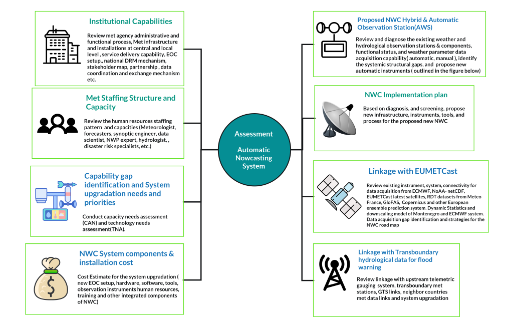
- Strategic methodology for diagnosing/screening of existing system, structure and process, efficiency, and efficacy:
- Conduct a desk review:
- Review of Hydro-meteorological forecasting product, outlook, warning, and alerting services,
- Review the Numerical weather prediction (NWP) system over the long, medium, and short-range forecasting products.
- Review the existing forecasting capabilities, modeling, ensemble system, and short-range forecasting process and capacities, as well as the ECMWF Montenegro and Balkan Region weather forecasts.
- Review the sector-specific operational forecasting (dynamic statistical and downscaling model for predicting rapidly developing weather conditions) products and services.
- Review reports on the hydrological situation, warnings, and forecasts produced by the Institute of Hydrometeorology, and Review Damage and Loss assessment tools.
- Review that hydrometeorological observations/monitoring systems are in place, including data acquisition, collation, management systems, and networks, and data exchange. Prepare multi-hazard analysis and mapping to support risk assessment and multi-hazard Early warning systems.
- Review reports on national climate multi-hazard risk and vulnerability assessment (CRVA), country risk profile
- Review all relevant technical reports, strategies, studies, research, and development on extreme weather events(frequency, intensity, landing pattern, trends, future threats, loss and damage category, and statistics), multi-hazards, and early warning mechanisms of Montenegro.
- Review Weather observation System (tools, technologies, instruments, data acquisition etc.):
- Diagnose the complete forecasting system, mechanism, weather observation system (number of automatic, telemetric, and manual), geolocation of weather observation system, spatial observation station gaps, number of river gauging stations, number of telemetric stations over the river system for tracking the synoptic conditions of the surface weather system.
- Review the clusters of observation technologies that are currently being deployed, including supercomputers, European Weather Clouds (NWC), limited area numerical models are being used, European ensemble prediction system( ECMWF, GFS, UKMO, Meteo France, etc.) , data analysis, reanalysis, bias-correction, ensemble model prediction, meteorological radars are deployed, drone radar technology, access to the latest EUMETCast satellite data system, and other relevant tools
- Review the institutional data sharing bottlenecks, access limitations to radar data from neighboring countries, and gap identification.
| Target audience/stakeholders | Consultation process | Expected outcome |
| Conduct in-depth interviews (Key Informant Interviews – KIIs) with key stakeholders/sectors (Government, national and sub-national entities), state and non-state actors, vulnerable communities, community leaders, and other special groups (indigenous), educational institutions, and Women’s Affairs organizations. Focus Group Discussions (FGDs) with key stakeholders & vulnerable communities. FGD & KII with CSO, CBO, development partners, I/NGOs, charities, women-led groups, commercial stakeholders, market promoters, and other relevant enterprises/actors/entities | FGD & KII | Conduct in-depth interviews (Key Informant Interviews – KII) with key stakeholders/sectors (Government, national and sub-national entities) & state, non-state actors, vulnerable communities, community leaders, and another special group(indigenous), educational institutes, Women’s Affairs organizations. Focus Group Discussions (FGDs) with key stakeholders & vulnerable communities. FGD & KII with CSO, CBO, development partners, I/NGOs, charities, women-led groups, commercial stakeholders, market promoters, and other relevant enterprises/actors/entities |
- Review the existing surface weather parameters (index, indices) and multi-hazards observation system /instrument for rapidly developing weather conditions across the country :
- Review the components of tracking weather parameters, number of automatic instruments, instruments for detecting convective weather conditions, thunderstorm, CAPE, trough, lightning, and rapidly developing thunderstorms (RDT) developed by Meteo France, EUMetcast, NOAA, etc.
- Review the national weather warning and alerting system and comprehensively assess the observation mechanism, system structure, capability, and performance to ensure robust warning systems.
- Review the current functionality of 51 hydrological stations (31 in Black Sea basin24 and 20 in Adriatic Sea basin) of which 31 are automatic and connected with the Centre in Podgorica. Gap identification over surface observation mechanism, overall observations, and strategy development for the new road map. Review the level of the hybrid observation system and assess its efficiency and efficacy.
- Review data collection tools, data collection, assimilation, and gap identification of sudden-onset extreme weather systems:
Improved nowcasting services depend on the highest density of surface hydrological information, multi-hazards are impending and take landfall, hazard incidence, and hotspot tracking (heavy rainfall, convective thunderstorm, hailstorm, high-winds, flashfloods, and landslide, etc.). Complying with the robust system, the surface-level hybrid observations are able to capture event situations and hotspots in a timely manner and feed into the nowcasting system. For upgrading to robust alerting for sectors, elements, and livelihoods, the following screenings are to be conducted.
- Review the data collection mechanism of ZHMS, the Hydrometeorological Institute of Montenegro
- Review multi-hazard data collection, collation, and GIS-based multi-hazard interpretations by the Hydrometeorological Institute of Montenegro and other relevant departments.
- The review mechanism of data is collected through meteorological, hydrological, and agrometeorological measurements, which monitor weather, water, and air, and are maintained by ZHMS.
- Review the framework and networking of flood forecasting system, real-time hydrometeorological data acquisition and access, most urgent flash flood prediction system, how they are accessing heavy rainfall data from AWS, measuring the extent of rainfall catchment areas, extent of basin, running flood model, providing flood forecasting and early warning, flood alerting to community and local level high-value installations and elements ( assets and economical) .
- Review the limitations of ZHMS in the forecasting of floods /flash floods, and GIS programs for automatic hazard monitoring.
- Conduct consultations with organizations to identify gaps in capacity and technology needs.
- Organize consultation with climate, hydrological, hydrographic, environmental and agrometeorological research institutes, National hydrometeorological services( NHMS) organizations, relevant organizations, institutions and agencies, academia; Directorate for Emergency Situations under the Ministry of Interior;, Institute for Hydrometeorology and Seismology of Montenegro (ZHMS), under the Ministry of Sustainable Development and Tourism; Ministry of Rural Development and Agriculture; Directorate for Water, under the Ministry of Rural development and Agriculture; Forestry Directorate, under the Ministry of Rural development and Agriculture; Local Authorities – Secretariats involved in water management, Ministry of Interior, Ministry of Defense; Ministry of Agriculture and Rural Development; Ministry of Sustainable Development and Tourism; Ministry of Health, Ministry of Science; Institute of Hydrometeorology and Seismology, Institute for Emergency Medical Services; Institute of Public Health, Red Cross of Montenegro, Agency for environmental protection and Center for eco-toxicological tests. Deputy Minister of Agriculture and Rural Development – Department of Water Management; The Ministry of Agriculture and Rural Development, the Institute for Hydrometeorology and Seismology of Montenegro, and the Ministry of Interior; The Ministry of Agriculture and Rural Development (MARD) is in charge of water management, Water Directorate (WD).
- Review the transboundary hydrological datasets for implementation of the European Union Water Framework Directive (WFD) and the Floods Directive.
- Review the capacity of the Directorate for Emergency Situations regarding data acquisition, collation, and processing capacity.
- Conduct site visits :
| Target locations | Site visits | Outcome |
| Site visits to high risk areas(flash flooding , landslide) and identify the causal relations of intensity and frequency of hydrometeorological extreme weather events, landscape , geographical settings, morphological characteristics, multi-hazard exposure, risk and vulnerability | Highly vulnerable areas Hydrometeorological stations and locations | Identify what type of instruments, technology , system and services are required for the robust NWC system |
- Organize national workshop /meeting with stakeholders, opinion sharing,g and recommendations:
| Target audience/stakeholders | Consultation process | Expected outcome |
| Conduct in-depth interviews (Key Informant Interviews – KII) with key stakeholders/sectors (Government national and sub-national entities) & state, non-state actors, vulnerable communities, community leaders, and another special group ( indigenous), educational institutes, Women affairs organizations. Focus Group Discussions (FGDs) with key stakeholders & vulnerable communities. FGD & KII with CSO, CBO, development partners, I/NGOs, charities, women-led groups, commercial stakeholders, market promoters, and other relevant enterprises/actors/entities | FGD & KII |
- Review the study findings and propose a Dynamic Plan for the Implementation of the NWC system.
- Based on comprehensive studies, consultations, and recommendations, prepare a roadmap of the overall system architecture, design, and item-wise instruments, tools, hardware, and software for upgrading real-time weather and multi-hazard observations. Develop a roadmap for the new NWC system.
- Organize lessons, learning meetings/workshops, capturing recommendations, and prepare the Final report
- Propose a detailed cost estimation for the Implementation of the NWC system
Prepare a detailed upgradation plan, budget, item-wise cost estimation of the instruments, hardware, software, installations, capacity building of the human resources, etc.
The Multi-hazard Early Warning Center (MHEWC) has the capacity to deploy low-cost, easy-to-maintain nowcasting services that enable real-time interpretation of up-to-date time-series weather parameter sensor data ingested instantly from meteorological stations.