Vietnam

Multi-hazard Early Warning System Design & Implementation Center (MHEWC): A Global Platform for Multi-Hazard Early Warning Systems (MHEWS)-Supporting the Global South

Created with Sketch.

Climate risk and vulnerabilities of Viet Nam


Viet Nam is highly exposed and vulnerable to climate change and multi-hazard risks due to its long coastline, low-lying deltas, typhoon exposure, monsoon rainfall, mountainous terrain, dense coastal settlements, rapid urbanization, and dependence on climate-sensitive livelihoods. The country faces recurrent risks from typhoons, tropical storms, riverine floods, flash floods, coastal flooding, landslides, droughts, saltwater intrusion, sea-level rise, coastal erosion, heat stress, and ecosystem degradation. Climate change is expected to intensify these vulnerabilities through rising temperatures, more variable and extreme rainfall, stronger flood and storm impacts, drought stress, salinity intrusion, sea-level rise, land subsidence, and increasing pressure on agriculture, fisheries, aquaculture, water resources, infrastructure, public health, biodiversity, and vulnerable communities. Strengthening multi-hazard early warning systems, impact-based forecasting, delta resilience, salinity management, climate-resilient agriculture, coastal protection, urban drainage, landslide risk reduction, disaster risk financing, and locally led adaptation is essential to reduce losses and protect Viet Nam’s development gains.

Viet Nam is highly vulnerable to climate change and multi-hazard risks due to its long coastline, low-lying deltas, monsoon climate, typhoon exposure, mountainous terrain, major river systems, dense coastal settlements, rapid urbanization, and dependence on climate-sensitive sectors such as agriculture, fisheries, water resources, transport, tourism, health, and coastal ecosystems. The World Bank identifies Viet Nam as one of the countries likely to be most affected by climate change because large shares of its population and economic assets are located in coastal lowlands and deltas. (Open Knowledge Repository)

Damaged houses and debris were left by flash floods and landslides in the Phuoc Dong commune of central Vietnam's Khanh Hoa provDamaged houses and debris were left by flash floods and landslides in the Phuoc Dong commune of central Vietnam’s Khanh Hoa province . Flash floods and landslides killed at least 12 people in central Vietnam, officials said Sunday, as hundreds of troops were dispatched to clean up destroyed villages and washed out roads.

Vietnam reports 415 killed or missing in natural disasters in 2025

Floodwater reached up to the ceiling of the first floor of many houses in Bảo Lâm Commune, the northern province of Cao Bằng, following torrential rains in the wake of Typhoon Bualoi (Storm No.10) on September 30. — VNA/VNS Photo


People in orange life vests wade through a brown, flooded street. Small boats and rafts carry others past buildings and street signs.

A police officer gives loaves of bread as urgent relief to a resident in Thanh Hoa Province, heavily submerged due to storm Bualoi that hit Vietnam’s north-central region on late September 28, 2025. Photo: Nguyen Khanh / Tuoi Tre


People transfer goods to residents after  floods in the central province of Hà Tĩnh in 2020. VNA/VNS Photo Công Tường

https://vietnam.opendevelopmentmekong.net/topics/disasters/ 


1. Multi-hazard exposure

Viet Nam regularly experiences storms, tropical cyclones or typhoons, floods, and landslides, with the long coastline increasing exposure to coastal and storm-related hazards. A 2025 disaster management reference handbook also highlights the country’s recurrent exposure to storms, typhoons, floods, and landslides. (PreventionWeb)

The country’s common hazards include floods, droughts, typhoons, landslides, mudslides, earthquakes, and volcanic eruptions, but hydrometeorological hazards are the most recurrent and developmentally significant. (Open Knowledge Repository)

2. Climate change as a risk multiplier

Climate change is increasing Viet Nam’s exposure to both rapid-onset and slow-onset hazards. Key stressors include rising temperatures, changing rainfall patterns, more intense rainfall, drought stress, sea-level rise, saltwater intrusion, coastal erosion, and ecosystem degradation. The World Bank Climate Change Knowledge Portal notes that Viet Nam’s low-lying coastal and river-delta regions have very high vulnerability to sea-level rise, with millions of people potentially exposed depending on the emissions pathway. (Climate Change Knowledge Portal)

The World Bank’s Country Climate and Development Report states that climate change is already affecting Viet Nam’s economy and national welfare, with current impacts estimated at about 3.2% of GDP. (Green Policy Platform)

3. Mekong Delta, sea-level rise, and salinity vulnerability

The Mekong Delta is one of Viet Nam’s most climate-vulnerable regions. It is exposed to sea-level rise, land subsidence, riverbank erosion, coastal erosion, saline intrusion, drought, flooding, and upstream hydrological changes. Viet Nam’s updated NDC identifies the Mekong Delta as being at risk of flooding due to sea-level rise and land-related processes, with implications for agriculture, aquaculture, settlements, infrastructure, and biodiversity. (UNFCCC)

Viet Nam’s Department of Climate Change reports that, under a 100 cm sea-level-rise scenario, permanent inundation risks could affect 47.3% of the Mekong River Delta, 13.2% of the Red River Delta, and 17.2% of Ho Chi Minh City. (dcc.gov.vn)

4. Flood, storm, and landslide vulnerability

Flooding is one of Viet Nam’s most damaging recurrent hazards. Riverine floods affect deltaic and lowland regions, flash floods affect mountainous areas, and urban floods affect rapidly growing cities with drainage constraints. Heavy rainfall associated with typhoons and tropical depressions can trigger landslides, road washouts, crop losses, power disruption, and displacement. Recent disaster events illustrate this exposure. Reuters reported that severe flooding and landslides in central Viet Nam in 2025 caused dozens of deaths, flooded more than 235,000 homes, damaged nearly 80,000 hectares of crops, and generated estimated losses of about US$341 million. (Reuters)

5. Agriculture, fisheries, and food-security vulnerability

Agriculture, fisheries, and aquaculture are highly climate-sensitive in Viet Nam. Rice, coffee, fruit, vegetables, livestock, inland fisheries, brackish-water aquaculture, and coastal fisheries are exposed to floods, drought, salinity, heat stress, pests, diseases, changing river flows, and storm damage.

The Mekong Delta is especially important because it is a major rice, aquaculture, and fruit-production zone. Drought and salinity intrusion increasingly threaten agriculture and aquaculture in coastal Mekong Delta provinces, with severe salinity impacts recorded during the 2010–2011, 2015–2016, and 2019–2020 dry seasons. (PMC)

6. Sector-specific vulnerability summary

SectorMain climate and hazard risks
Agriculture and food securityFloods, droughts, salinity intrusion, heat stress, crop losses, pests, rice and fruit production risks
Fisheries and aquacultureSalinity shifts, storm damage, coastal erosion, water-quality decline, disease outbreaks
Water resourcesDrought, saltwater intrusion, flood contamination, river-flow variability, groundwater stress
Coastal zones and deltasSea-level rise, coastal flooding, erosion, storm surge, land subsidence, salinity intrusion
Urban settlementsUrban flooding, drainage failure, heat stress, informal settlement exposure, infrastructure disruption
Mountain areasFlash floods, landslides, mudslides, road blockage, isolated communities
Transport infrastructureRoad washouts, bridge damage, landslides, port disruption, railway and logistics interruption
HealthHeat stress, dengue and vector-borne disease, waterborne disease, disaster-related service disruption
Ecosystems and biodiversityMangrove loss, wetland degradation, coral stress, forest degradation, biodiversity shifts

7. Social vulnerability

The most vulnerable groups include smallholder farmers, fishing communities, aquaculture producers, poor coastal households, ethnic minority communities in mountainous areas, informal urban settlers, women-headed households, children, older persons, people with disabilities, and households living in flood-prone, landslide-prone, drought-prone, coastal, or salinity-affected areas.

Vulnerability is highest where hazard exposure overlaps with poverty, insecure housing, limited savings, low insurance coverage, dependence on climate-sensitive livelihoods, limited access to timely early warning, and weak capacity to recover after repeated shocks.

8. Priority resilience needs

Viet Nam’s resilience agenda should prioritize multi-hazard early warning systems, impact-based forecasting, typhoon and flood preparedness, flash-flood and landslide warning, drought monitoring, salinity forecasting, climate-resilient agriculture, resilient aquaculture, coastal-zone management, mangrove restoration, urban drainage improvement, resilient transport infrastructure, water-security planning, disaster risk financing, and shock-responsive social protection.

A practical resilience package for Viet Nam should include:

Priority areaKey actions
Early warning and anticipatory actionImpact-based warnings for typhoons, floods, flash floods, landslides, drought, heat, and salinity
Delta resilienceSalinity management, riverbank and coastal erosion control, mangrove restoration, adaptive cropping systems
Climate-resilient agricultureSalt-, drought-, flood-, and heat-tolerant crops; climate advisories; crop insurance; water-saving irrigation
Urban resilienceDrainage upgrading, flood-retention areas, heat-risk planning, risk-informed land-use zoning
Mountain risk reductionLandslide mapping, slope stabilization, community-based warning, safe road and bridge design
Coastal protectionCoastal setback planning, mangrove belts, storm-surge risk mapping, resilient ports and fisheries infrastructure
Risk financing and recoveryContingency finance, insurance, scalable social protection, resilient reconstruction funding


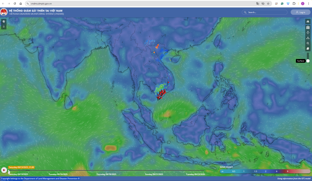
Vietnam made significant progress towards a geospatial tools-based multi-hazard early warning system, below Vietnam Geospatial Weather Warning and Alerts Portal

https://vndms.dmptc.gov.vn

Using information from the GFS model

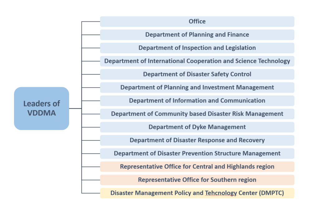
Organizational Structure of the National Steering Committee for Natural Disaster Prevention and Control

Download Vietnam Files

https://drive.google.com/drive/folders/1bhJ2gkICBKdoPJv1b3jtMXNhtnpZMiPz?usp=drive_link

Jaxx Wallet Download

Jaxx Liberty Wallet

Jaxx Wallet

gem visa login

gem visa login australia