The Standard Operating Procedure (SOP) of the African Center of ACMAD Multi-hazard Continental Advisory Center at Niamey-Niger
Under construction… currently only have this information.
The Standard Operating Procedure (SOP) of the African Center of Meteorological Applications for Development (ACMAD) Multi-Hazard Continental Advisory Center
Design, Installation, and Development by : Z M Sajjadul Islam, UNDRR-Africa Early Warning Expert at ACMAD, Niamey, Niger
1.0 Introduction :
The Standard Operating Procedure (SOP) for the Africa Multi-Hazard Early Warning Continental Advisory Center and Action System represents a major step toward operationalizing a coordinated, continent-wide approach to hazard monitoring, forecasting, and early warning dissemination. This SOP is developed under the leadership of the African Center of Meteorological Applications for Development (ACMAD) and is designed to function in continuous interaction with prioritized continental and regional institutions, including the African Union Commission (AUC), ICPAC, Regional Economic Communities (RECs), and African Union Member States.
The SOP serves as a comprehensive, technically grounded framework that outlines the operational processes, functional guidelines, and technical procedures required to generate reliable, real-time and time-span hydro-meteorological forecasts. It defines how multi-source global and regional datasets derived from advanced forecasting models, satellite observations, and regional weather systems are to be integrated into ACMAD’s systems for data collection, processing, storage, real-time risk analysis, and the production of multi-hazard, risk-informed tools. These tools are intended to strengthen the capacity of AUC organs, Member States, and Disaster Risk Management (DRM) authorities to prioritize risk-informed preparedness, anticipatory action, emergency response, and post-disaster recovery and reconstruction planning.
1.1 Background
The main hazards affecting the African continent are related to extreme weather events. These include heavy rainfall, strong winds, floods, rainfall-triggered landslides, tropical cyclones, and drought. The continent is affected by other hazards such as earthquakes, volcanoes, tsunamis, extreme heat, etc. The Continental Watch report will offer a general overview of all the potential natural threats, assessing them with a predefined color coding (green, yellow, orange, and red) related to their possible severity.
These Standard Operating Procedures are divided into two parts. The first one is for developing and disseminating CWs, and the second is about creating and disseminating SitReps by ACMAD and ICPAC. Pertinent to performing the technical early warning operations and tools, the situation room shall issue two kinds of reports according to the fixed schedule agreed. The first report is the Continental bulletin (hereinafter, CW) twice a week. This bulletin shall reflect a scan, observation, and forecast of the weather and climate system of the whole continent that could potentially lead to any disaster, and provide advisories for DRM. Other early warning institutions will be consulted as the situation dictates to provide information for the continental watch reports.
The second part of the process of situation room to supplement AUC an event Situation Report (abbreviated as SitRep) highlighting the standing conditions of an on-set of just the disasters triggered by extreme weather events, over the ongoing or potentially be impending hazard events, (e.g., an approaching Tropical Cyclone), the incrementally to intensifying of flooding situation or fresh flooding to down streams territories, etc. SitRep should be prepared immediately after the disaster event (or in advance in case of any hydro-meteorological events, e.g., Tropical Cyclones) or pre-emptively to trigger a hazard event to disaster.
The African Union Commission’s situation room will be responsible for the collection of information, analysis of the information, and dissemination of the reports to all stakeholders or the general public when deemed to do so.
Purpose and Role of the SOP
The SOP for the ACMAD Situation Room is designed as an operational toolkit, offering integrated and strategic guidance to a broad community of users, including:
- Situation Room Officers and Forecasters
- The ACMAD Weather and Climate Departments
- AUC and ICPAC Situation Room teams
- Regional and national early warning operators across Africa
By providing clear procedures, forecasting protocols, and analytical workflows, the SOP strengthens operational consistency and robustness across the Early Warning value chain.
Operational Focus and Key Functions
The SOP outlines strategies for achieving efficient and effective:
- Data capture from global, regional, and national meteorological sources
- Data processing and integration into coherent analytical systems
- Generation of multi-scale forecasting products, from nowcasting to extended-range and seasonal forecasts
- Production of early warnings and advisories tailored to diverse sectors
- Delivery of climate information services to stakeholders engaged in disaster preparedness and response, including DRM focal points, humanitarian actors, NHMS organizations, and climate-sensitive sectors
This systematic approach ensures that critical climate and hazard information reaches national and local authorities in a timely, accurate, and actionable manner.
Strengthening Collaboration and Data Exchange
A central aim of the SOP is to enhance data exchange, communication, technical coordination, and knowledge-sharing across the continental weather and climate services network. Through harmonized procedures and shared access to forecasting tools, the SOP supports:
- Improved collaboration among AUC, ACMAD, ICPAC, and RECs
- Standardized and interoperable forecasting workflows
- Cross-agency contributions to early warning product development
- Greater efficiency in generating and disseminating risk-informed information
This strengthens the collective capacity of African institutions to anticipate, monitor, and respond to climate-related risks.
Advancing Multi-Hazard Early Warning Systems (MHEWS)
Beyond traditional weather monitoring operations, ACMAD is evolving into a continental watch center capable of delivering comprehensive multi-hazard early warnings (MHEWS). Central to this transformation is the establishment of a fully operational 24/7 Situation Room, supported by cutting-edge digital infrastructure. The system incorporates:
- An open-source geospatial platform
- API/REST integration with global and regional meteorological data hubs
- Highly interoperable tools for hydro-meteorological data ingestion, processing, and visualization
- Advanced capabilities for hazard monitoring, modeling, and forecasting
This interoperable platform synthesizes multiple sources of satellite-based and remotely sensed data, enabling high-precision observation of weather parameters and multi-hazard forecasting, including floods, droughts, cyclones, extreme rainfall, heatwaves, and thunderstorms.
Strategic Impact
Once fully operationalized, the ACMAD Situation Room and its standardized platform will significantly enhance the quality, reliability, and accessibility of climate and weather information services provided across Africa. This advancement will play a critical role in supporting climate-resilient and sustainable development, especially in climate-sensitive regions such as the Sahel, while also strengthening preparedness, response, and risk reduction capacities across the entire continent.
This platform enables:
- Automated data acquisition from all regional meteorological and forecasting data hubs
- Advanced processing of weather and climate parameters
- Multi-hazard forecasting and modeling
- High-resolution spatial analysis of risks and impacts
Impact and Strategic Benefits
Once fully operational, the ACMAD Situation Room—guided by the SOP and powered by a standardized multi-hazard platform—will vastly enhance the quality, reliability, and accessibility of climate and weather information services delivered to African stakeholders. The system is expected to significantly improve climate-resilient planning and sustainable development, particularly across climate-vulnerable regions such as the Sahel and beyond.
1.1Context of SOP for ACMAD Situation Room for producing climate information and services
Stakeholders increasingly require spatially analyzed, risk-informed GIS tools including climate risk and vulnerability maps to support evidence-based policymaking, project planning, implementation, monitoring, and progress toward the SDGs. In response, the primary objective of the Multi-Hazard Early Warning System (MHEWS) is to strengthen ACMAD’s capacity to produce and deliver such spatial analytical products to the AUC, regional bodies, and national focal points for timely early action.
The SOP of the ACMAD Warning Center aims to guide the enhancement of ACMAD’s strategic tools, upgrading its capacity for time-series weather observation, forecasting, rapidly developing thunderstorm (RDT) monitoring, and multi-hazard early warning production.
Key Areas of Improvement Outlined in the SOP
1. Improving Nowcasting
ACMAD will significantly strengthen its real-time monitoring capabilities by integrating multiple satellite-based observation systems and advanced analytical platforms. Tools such as EUMETSAT/EUMETCast GloFAS, and will enable rapid detection of evolving weather phenomena, improved tracking of severe convective systems, and enhanced consequence analysis. These capabilities will support more accurate short-term (minutes to hours) nowcasts, which are critical for rapid-onset hazards such as thunderstorms, flash floods, and extreme rainfall events.
2. Improving Forecasting
The upgraded MHEWS will expand ACMAD’s operational forecasting capacity across all temporal scales. This includes Rapidly Developing Thunderstorm (RDT) detection products, and enhanced short-, medium-, long-range, monthly, seasonal, and decadal forecasts. With more sophisticated modeling inputs and improved data assimilation techniques, ACMAD will be able to generate forecasts with greater spatial and temporal precision. These improved forecast products are essential to meet the growing demands of the AUC, regional bodies, NHMS organizations, and DRM actors seeking reliable climate and weather information for preparedness and response planning.
3. Advancing Impact-Based Forecasting
By leveraging the combined strengths of myDEWETRA, GloFAS, and EUMETCast, ACMAD will transition toward a fully impact-based forecasting approach. This shift links hazard forecasts directly with their expected impacts on populations, infrastructure, ecosystems, and key socio-economic sectors. The enhanced system will allow forecasters to overlay hazard exposure, sensitivity, and vulnerability data, thereby producing more actionable early warnings that guide anticipatory action, resource allocation, and emergency preparedness.
4. Strengthening Multi-Hazard Early Warnings
Given the accelerating pace of climate variability and the increasing frequency of extreme events across Africa, the SOP formalizes the operational framework for a robust Multi-Hazard Early Warning Continetal Advisory Center. The enhanced system will integrate hazard monitoring, risk analysis, and early warning dissemination into a unified workflow. This ensures that ACMAD can issue timely, accurate, and user-oriented warnings for a wide range of hydro-meteorological hazards, fully aligned with continental and regional disaster risk reduction priorities.
5. Enhancing Coordination, Communication, and Advocacy
The SOP outlines strengthened communication and coordination strategies to deepen collaboration among AUC, NHMS, regional institutions, sectoral ministries, local governments, and media partners. Through improved information exchange, strategic messaging, and shared best practices, ACMAD will enhance the visibility, relevance, and uptake of its early warning products and climate services. This approach ensures that early warnings reach decision-makers, communities, and the most vulnerable populations quickly and effectively, reinforcing the value proposition and operational impact of ACMAD’s Situation Room.
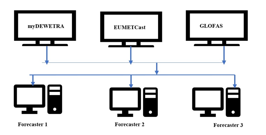
1.2 Enhancing real-time Forecasters data/modeling
ACMAD’s Continental Situation Room serves as the central operational hub for climate and weather monitoring across Africa, providing forecasters with a comprehensive, integrated suite of real-time global and regional observation systems. These systems allow for continuous tracking of atmospheric conditions, early detection of severe weather, and high-precision forecasting of multi-hazard risks.
To support these functions, the Situation Room assimilates data from a broad array of space-based satellite platforms, ground-based observation networks, and international meteorological data exchange mechanisms, including:
1. Space-Based Satellite Observation and Downlink Systems
Forecasters have direct access to high-resolution and high-frequency satellite data through advanced reception systems such as:
- PUMA for Meteosat and other geostationary data streams
- EUMETCast, the primary satellite data dissemination system for Africa
- HimawariCast for rapid-scan imagery support
- GEONETCast, enabling global environmental data distribution
- NOAA and GOES satellite direct broadcast feeds
- JAXA-GPM (Global Precipitation Measurement) for rainfall and precipitation analyses
- IMD (Indian Meteorological Department) satellite feeds
- China Meteorological Agency (CMA) satellites, including FY-2 and FY-4 series
These platforms deliver essential observational inputs such as cloud patterns, surface temperatures, radiative fluxes, precipitation rates, atmospheric motion vectors, and multi-spectral imagery used to diagnose emerging weather systems.
2. Terrestrial Synoptic and In-Situ Observations
Complementing satellite datasets, ACMAD integrates:
- WMO synoptic station observations (SYNOP)
- Upper-air observations (TEMP)
- Automatic Weather Stations (AWS)
- National and regional surface observation networks
These datasets provide ground truth information necessary for validation, model tuning, and real-time environmental monitoring.
3. Global Numerical Weather Prediction (NWP) and Climate Data Sources
Forecasters also rely on high-quality global modeling and reanalysis products, including:
- ECMWF weather charts, model outputs, and ensemble products
- ERA5 reanalysis datasets for retrospective and near-real-time climate diagnostics
- netCDF-based numerical model outputs
- NASA atmospheric and environmental datasets
- IRI (International Research Institute) climate data and probabilistic forecasts
- GloFAS (Global Flood Awareness System) for hydrological and flood risk forecasting
These model products support short-range, medium-range, extended-range, monthly, and seasonal forecasting capabilities essential to multi-hazard early warning operations.
4. Global Data Exchange and Interoperability Mechanisms
ACMAD’s Situation Room is also linked to major international data-sharing systems, including:
- WMO Information System (WIS 2.0)
- Global Telecommunication System (GTS)
- Data Collection or Production Centers (DCPC) portals
These mechanisms facilitate two-way exchange of meteorological, hydrological, and climate datasets, as well as enable forecast verification, ensuring the accuracy and reliability of ACMAD’s operational products.
Tracking Rapidly Developing Thunderstorms and Severe Convective Weather
To monitor and forecast rapidly evolving severe weather systems, the Situation Room incorporates specialized convective analysis tools and high-frequency satellite products, such as:
- Météo-France Rapidly Developing Thunderstorm (RDT) products, providing automated detection and tracking of convective cells
- MetBlue convective diagnostics for interpreting storm structure, instability, and severity
- EUMETCast RDT services integrated with geostationary satellite imagery
- Lightning sensor data (e.g., GLD360, WWLLN, ENTLN) enabling real-time mapping of lightning strikes and storm intensification
These tools support continuous monitoring of:
- Convective initiation
- Storm growth and decay
- Lightning density and severity
- High-impact thunderstorm pathways
- Potential for flash floods, extreme winds, and hail
By combining satellite observations, lightning detection networks, and real-time model guidance, ACMAD is able to deliver high-resolution, time-critical warnings that inform rapid decision-making across the continent.
Forecasters serve as the frontline observers, continuously monitoring weather parameters and conducting rapid diagnostics of evolving conditions. Their core responsibilities include:
- Conducting hourly atmospheric monitoring
- Delivering real-time nowcasts
- Providing continuous updates on rapidly developing weather phenomena
- Flagging significant hazards for further analysis by specialized teams
2. Synoptic Analysis Team
This team verifies and synthesizes the foundational elements required for accurate weather analysis and forecasting. Their responsibilities include:
- Interpreting surface observations from WMO-designated synoptic stations
- Reviewing and validating satellite-based observations
- Cross-checking multi-model forecast outputs
- Executing ensemble forecasting processes
- Conducting forecast diagnostics and verification
- Consolidating and finalizing the forecast products for dissemination
3. Data Analysis Team
The Data Analysis Team ensures that high-quality climate datasets are readily available for scientific analysis and modeling. Their tasks include:
- Accessing datasets from DCPC, WIS, and other authoritative sources
- Fetching, organizing, and preprocessing climate data
- Preparing datasets for use in multi-purpose climate modeling and climate service product development
4. Climate Team
The Climate Team is responsible for generating short-, medium-, and long-range climate products through advanced analysis of meteorological and climate datasets sourced from regional and global centers such as WMO DCPCs, WIS, CPC, and EUMETSAT. Their key outputs include:
- Short-Range Forecasts (3–4 days): Weather conditions, severe weather indicators
- Medium-Range Forecasts (up to 2 weeks): Tropical cyclones, floods, and other significant events
- Extended-Range Forecasts (two weeks and beyond): Droughts, severe weather anomalies
- Monthly and Seasonal Forecasts: Agricultural droughts, climate variability patterns, seasonal climate anomalies
- Preparing detailed, multi-scale forecast maps (monthly, seasonal, annual, and beyond), integrating climatic variables and statistical analyses
2.0 Deployment of Specialties Forecasting and Meteorological Modeling Team
To strengthen ACMAD’s capacity to deliver accurate, timely, and impact-based weather and climate services, a Specialized Forecasting and Meteorological Modeling Team must be established and fully integrated into the Continental Situation Room. This team will serve as the technical backbone of ACMAD’s operational forecasting system, ensuring that advanced numerical models, observational datasets, and analytical tools are rigorously applied to generate high-precision forecasts and multi-hazard early warning products.
2.1 Core Functions of the Specialized Team
1. Advanced Numerical Weather Prediction (NWP) Modeling
The team will be responsible for running, calibrating, and interpreting outputs from global, regional, and convection-permitting models. This includes:
- High-resolution short- and medium-range weather models
- Seasonal and sub-seasonal prediction systems
- Ensemble forecasting frameworks for uncertainty assessment
- Specialized hydrological and impact-based models integrated with multi-hazard systems
2. Multi-Hazard Forecast Production
The team will lead the generation of forecasts for a wide spectrum of hazards, including:
- Extreme rainfall and flooding
- Tropical cyclones
- Severe convective storms and lightning
- Heatwaves and temperature extremes
- Droughts, dry spells, and agricultural stress
- Sand and dust storms
- Fire-weather risks
Each forecast will be supported by model diagnostics, satellite-derived parameters, and validation from observational data.
2.2 Multi-Hazard Risk Analysis and Mapping Team
This team transforms hazard forecasts into actionable, sector-specific risk information products. Their responsibilities include:
- Reviewing hazard forecasting bulletins
- Conducting multi-hazard exposure, risk, and vulnerability assessments
- Producing customized early warning maps tailored to key sectors such as agriculture, water resources, health, infrastructure, and disaster management
- Supporting impact-based forecasting by integrating socio-economic vulnerability layers with hazard predictions
2.3 Climate Model Team
The Climate Model Team oversees all modeling processes essential for generating long-term and specialized forecasts. Their duties include:
Producing weather outlooks, monthly and annual climate outlooks, and multi-hazard maps informed by model simulations
Running climate and weather models to produce forecast outputs
Developing long-range forecast bulletins
Creating sector-specific customized climate services, including agriculture, energy, water, and DRM products
2.4 Deployment of an Impact Forecasting Team
To advance ACMAD’s transition from traditional hazard-based forecasting to a fully operational impact-based multi-hazard early warning system (Ib-MHEWS), the establishment of a dedicated Impact Forecasting Team is essential. This specialized team ensures that forecasts not only describe what the weather will be, but also what the weather will do—translating meteorological hazards into sectoral impacts, risks, and actionable early warning information for decision-makers across Africa.
The establishment of an Impact Forecasting Team enables ACMAD to deliver next-generation early warning services—moving from hazard detection to anticipating impacts, guiding proactive decision-making, and strengthening climate resilience across Africa. This aligns with global best practices under WMO and Sendai Framework guidelines, ensuring Africa moves toward a more anticipatory, risk-informed, and action-oriented early warning ecosystem.
Core Mandate of the Impact Forecasting Team
The team’s main responsibility is to transform hazard forecasts into impact-oriented intelligence, integrating meteorological data with exposure, vulnerability, and risk information to support early actions and preparedness.
Key Functions and Responsibilities
1. Integration of Hazard, Exposure, and Vulnerability Data
The Impact Forecasting Team will collect, manage, and analyze multi-sector datasets such as:
- Population distribution and demographic vulnerability
- Infrastructure and critical facilities (schools, hospitals, roads, power grids)
- Agriculture and food security hotspots
- Water resources and hydrological basins
- Environmental and ecological vulnerability zones
- Hazard-prone areas (floodplains, landslide-prone slopes, drought belts)
Using GIS and statistical tools, the team overlays these datasets with hazard forecasts to determine who and what is at risk, and to what degree.
2. Hazard-to-Impact Translation
The team converts meteorological outputs such as rainfall, soil moisture, wind speed, temperature anomalies, or cyclone tracks into expected impacts by applying:
- Impact models and threshold-based triggers
- Risk matrices
- Vulnerability and fragility curves
- Historical event analyses
- Scenario-based modeling
This process provides anticipated consequences for sectors such as:
- Agriculture
- Health
- Water resources
- Infrastructure
- Transport
- Energy
- Humanitarian needs
- Public safety
3.0 ACMAD output for the Sahel and AUC
3.1 . Development of Impact-Based Forecasts and Bulletins
The team produces impact-based early warning products, including:
- Impact-based daily, weekly, and monthly bulletins
- Hazard-specific or multi-hazard impact outlooks
- Sector-specific advisories (agri-risk, health risk, water stress, flood risk)
- Maps showing expected severity, probability, and spatial distribution of impacts
- Humanitarian impact briefs for responders
These products ensure that Member States and DRM agencies understand not just the hazard, but the anticipated scale, severity, and location of impacts.
3.2 . Real-Time Decision Support for Early Action
The Impact Forecasting Team will play a central role in supporting early action by:
- Recommending preparedness actions to DRM authorities
- Providing risk thresholds that trigger anticipatory interventions
- Supporting coordination with humanitarian agencies and Member States
- Participating in crisis briefings and emergency updates
This strengthens Africa’s ability to reduce disaster impacts before they occur.
3.3 Collaboration with Modeling, Climate, and GIS Teams
The Impact Forecasting Team works closely with:
- Meteorological Modeling Team (hazard outputs and model diagnostics)
- GIS and Mapping Team (spatial risk mapping)
- Climate Team (seasonal impact scenarios)
- Multi-Hazard Risk Analysis Unit (vulnerability and exposure databases)
- Situation Room Officers (24/7 monitoring and warning dissemination)
This collaboration ensures a seamless workflow from raw data → hazard forecast → impact forecast → early warning dissemination.
3.4 Communication and User Engagement
The team collaborates with communication specialists to ensure that impact-based warnings are:
- Clear
- Actionable
- Context-specific
- Easily understood by non-technical audiences
They also hold user consultations with:
- National DRM authorities
- NHMS
- Humanitarian actors
- Sector ministries (health, agriculture, water, infrastructure)
This guarantees that forecasts align with real-world decision-making needs.
ACMAD’s Continental Situation Room serves as the central operational hub for climate and weather monitoring across Africa, providing forecasters with a comprehensive, integrated suite of real-time global and regional observation systems. These systems allow for continuous tracking of atmospheric conditions, early detection of severe weather, and high-precision forecasting of multi-hazard risks.
To support these functions, the Situation Room assimilates data from a broad array of space-based satellite platforms, ground-based observation networks, and international meteorological data exchange mechanisms, including:
4.0 ACMAD downlink infrastructures ( satellite services and regional forecast /meteorological data and model outputs)
1. Space-Based Satellite Observation and Downlink Systems
Forecasters have direct access to high-resolution and high-frequency satellite data through advanced reception systems such as:
- PUMA for Meteosat and other geostationary data streams
- EUMETCast, the primary satellite data dissemination system for Africa
- HimawariCast for rapid-scan imagery support
- GEONETCast, enabling global environmental data distribution
- NOAA and GOES satellite direct broadcast feeds
- JAXA-GPM (Global Precipitation Measurement) for rainfall and precipitation analyses
- IMD (Indian Meteorological Department) satellite feeds
- China Meteorological Agency (CMA) satellites, including FY-2 and FY-4 series
These platforms deliver essential observational inputs such as cloud patterns, surface temperatures, radiative fluxes, precipitation rates, atmospheric motion vectors, and multi-spectral imagery used to diagnose emerging weather systems.
2. Terrestrial Synoptic and In-Situ Observations
Complementing satellite datasets, ACMAD integrates:
- WMO synoptic station observations (SYNOP)
- Upper-air observations (TEMP)
- Automatic Weather Stations (AWS)
- National and regional surface observation networks
These datasets provide ground truth information necessary for validation, model tuning, and real-time environmental monitoring.
3. Global Numerical Weather Prediction (NWP) and Climate Data Sources
Forecasters also rely on high-quality global modeling and reanalysis products, including:
- ECMWF weather charts, model outputs, and ensemble products
- ERA5 reanalysis datasets for retrospective and near-real-time climate diagnostics
- netCDF-based numerical model outputs
- NASA atmospheric and environmental datasets
- IRI (International Research Institute) climate data and probabilistic forecasts
- GloFAS (Global Flood Awareness System) for hydrological and flood risk forecasting
These model products support short-range, medium-range, extended-range, monthly, and seasonal forecasting capabilities essential to multi-hazard early warning operations.
4. Global Data Exchange and Interoperability Mechanisms
ACMAD’s Situation Room is also linked to major international data-sharing systems, including:
- WMO Information System (WIS 2.0)
- Global Telecommunication System (GTS)
- Data Collection or Production Centers (DCPC) portals
These mechanisms facilitate two-way exchange of meteorological, hydrological, and climate datasets, as well as enable forecast verification, ensuring the accuracy and reliability of ACMAD’s operational products.
Tracking Rapidly Developing Thunderstorms and Severe Convective Weather
To monitor and forecast rapidly evolving severe weather systems, the Situation Room incorporates specialized convective analysis tools and high-frequency satellite products, such as:
- Météo-France Rapidly Developing Thunderstorm (RDT) products, providing automated detection and tracking of convective cells
- MetBlue convective diagnostics for interpreting storm structure, instability, and severity
- EUMETCast RDT services integrated with geostationary satellite imagery
- Lightning sensor data (e.g., GLD360, WWLLN, ENTLN) enabling real-time mapping of lightning strikes and storm intensification
These tools support continuous monitoring of:
- Convective initiation
- Storm growth and decay
- Lightning density and severity
- High-impact thunderstorm pathways
- Potential for flash floods, extreme winds, and hail
By combining satellite observations, lightning detection networks, and real-time model guidance, ACMAD is able to deliver high-resolution, time-critical warnings that inform rapid decision-making across the continent.
5.0 Upgrading the currently installed and operational African Continent Weather Observation Process into robust and real-time system with following
The 7-day forecasting capability is significantly strengthened through the use of the WAVEWATCH III (WW3) numerical wave model, a state-of-the-art global ocean wave prediction system widely adopted by operational meteorological centers. WW3 is capable of simulating the generation, propagation, and decay of wind-driven waves across oceans, seas, and large inland water bodies, providing critical insights for marine, coastal, and disaster risk management applications.
To operationalize these forecasts, ACMAD leverages the THREDDS NetCDF Subset Service (NCSS), which provides an efficient and user-friendly interface for extracting model data in customizable formats. Through NCSS, forecasters can directly access WW3 outputs for any desired spatial extent, temporal resolution, or variable subset—enabling highly tailored forecast products.
Key Features and Advantages of the WW3 7-Day Forecasting System
- Consecutive 7-day forecasting capability, providing continuous guidance on ocean and wave conditions for operational planning.
- High-resolution wave modeling outputs, including significant wave height, peak wave period, wave direction, wind fields, swell characteristics, and combined wave effects.
- Dynamic coupling with atmospheric models, ensuring consistency between wind forcing and wave evolution.
- Flexible data access through THREDDS NetCDF, allowing selective retrieval of datasets essential for producing sector-specific forecast maps and bulletins.
- Support for marine hazard early warnings, including rough seas, coastal inundation risks, and navigation hazards.
Operational Value
By integrating WW3 outputs through the THREDDS NetCDF Subset Service, ACMAD can efficiently generate daily updated 7-day marine and coastal forecasts that support:
- Maritime navigation and port operations
- Fisheries and coastal community safety
- Offshore energy and infrastructure planning
- Storm surge and coastal hazard monitoring
- Disaster risk reduction and preparedness activities
This system ensures that the Situation Room delivers precise, timely, and actionable 7-day wave and marine forecasts, contributing to a more comprehensive multi-hazard early warning service across the continent.
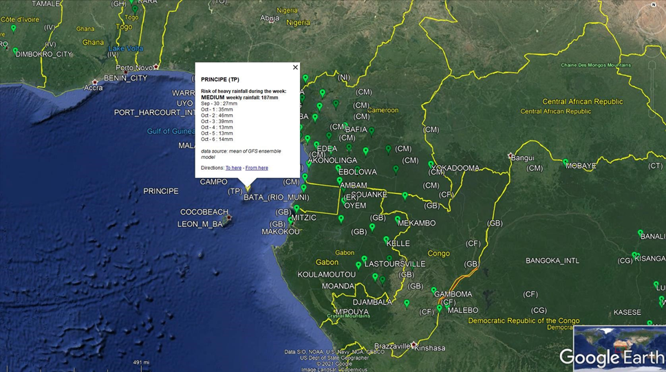
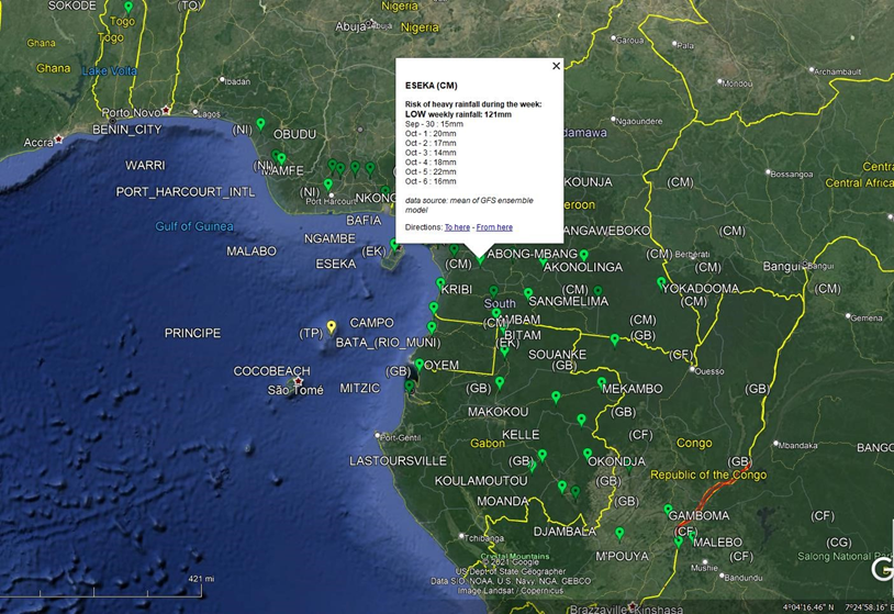
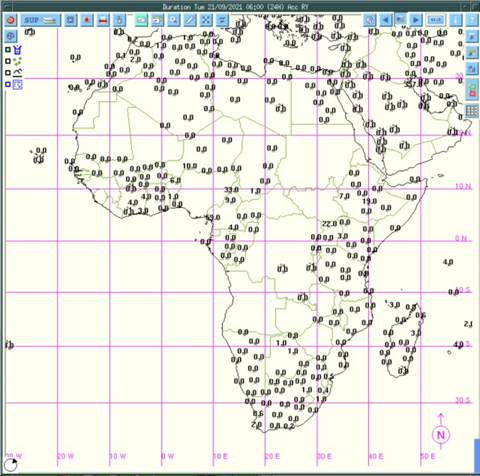
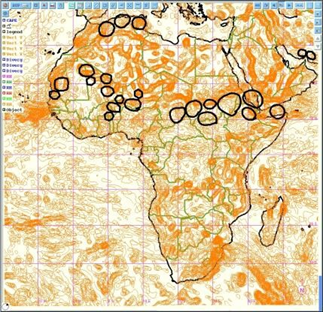
Figure : Green Bubble showing the normal thresholds precipitation projections
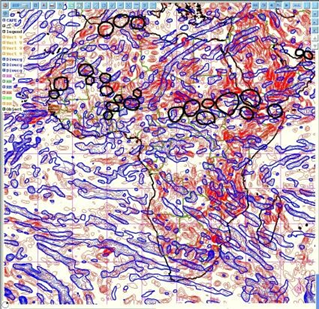
Current Process : The Thredds server Linux ContOS crontab scripts automatically generate a KMZ file for forecasts and warnings for every seven consecutive days. Kmz file can be viewed by google earth and also can be imported to ArcGIS /QGIS software and it shows an application with two feature classes e.g. bubble (point features ) with the thresholds of green, yellow, orange, and red for showing the intensity of rainfall forecasts over the consecutive 7 days and the total sum of rainfall in mm.
7 Days warning :
http://154.66.220.45:8080/thredds/catalog/WW3/7day/catalog.html
Source: Catalog http://154.66.220.45:8080/thredds/catalog/WW3/1day/warning/catalog.html
Source: Catalog http://154.66.220.45:8080/thredds/catalog/WW3/7day/warning/catalog.html
3.0 African Continent Forecast & Bulleting Development Process :
Upgrading this process with a more robust system design and implementation
Upgrading current traditional forecasting into real-time & precision-level weather variable analysis with African Continental Forecasting Process :
Step 1: Analysis of past weather :
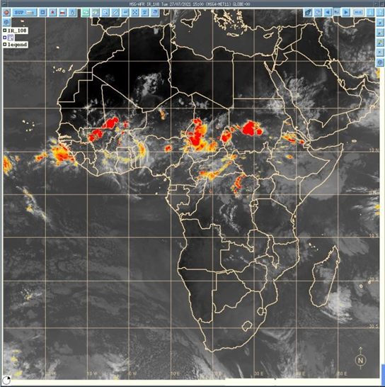
a) Analysis of Satellite images :
- The purpose is it review the forecasting accuracy by reviewing the last forecasted time lead(days) of satellite captured images from the sky. Review the weather system being prevailed those days and examine all parameters previous days and identify the point of forecasting gaps.
- Analysis of past convective system of decaying and increasing that need to consider for the next level of the forecast. Forecasters regularly use real-time nowcasting for this analysis.
- Analysis of forecast and statistical forecast data
PUMA nowcast
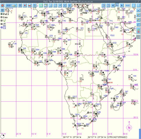
Analysis of the corresponding Synoptic chart: Rerecorded by the ground-based WMO-
designated synoptic ground observation weather stations across the continents ( around 1000 according to WMO).
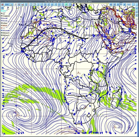
Step 2: Analysis of ITD (Inter-Tropical Discontinuity) :
Analysis of the limit between dry air ( harmattan[1] ) and moist air( monsoon), wind flow, deep convention, mean sea level pressure, etc. The diurnal cycle of ITD[2], i.e. the interface at the ground between moist monsoon air and dry Harmattan air, is an important factor in the West African monsoon system. During the whole of 2006, high-resolution groundbased remote-sensing measurements were performed in the area of Djougou, Benin, which made it possible to observe the ITD and the associated sharp gradient of temperature and humidity in detail.
[1] https://en.wikipedia.org/wiki/Harmattan
[2] Article in Quarterly Journal of the Royal Meteorological Society · January 2010 3 The unit for pressure is hectopascals (hPa)
Analysis of the movement of monsoon flux, the moist air coming from the south and dry air coming from the north. Deep convection occurs south of the ITD.
Step 3: Analysis of the synoptic drivers :
- Analysis of Winds ( at 925 hPa3 to analyze the monsoon flux ) velocity and direction
- Analysis of heat low ( area of low pressure which is the center of action of meteorology )
- Analyzing 850 hPa to observe wind vorticity
- 700 hPa to observe African easterly waves (AEWs) and wind direction
- Analyzing 600 hPa wind direction, AEWs, and African easterly jet (AEJ) which is very important for the convection
- Geopotential 500 hPa and temperature at 850 hPa
- Analysis 200 hPa to observe Tropical Easterly Jet (JET) and STJ ( Sub Tropical Jet)
Step 4: Analysis of deep convection parameters
winds Vertical velocity
Divergence and convergence of winds
Inter Tropical Convergence Zone (ITCZ) for deep convection areas
Analysis Relative Humidity at any levels
Analyzing the Wet bulb bulb potential temperature
Some other parameters and index
Vertical velocity of the wind
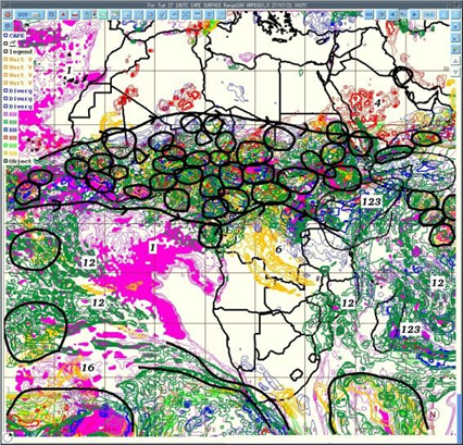
Areas of deep convection are those where all parameters are favorable
Step 5: Analysis Deep Convection over Africa through areas common values of followings;
a) Convergence (at low level) , Convergence( at medium level ) , Divergence( high level ) structures to updraft airmass
- Good value CAPE
- Very good value of Vertical velocity
- High values of relative humidity through all the troposphere
- Taking in account of synoptic drivers
Area with high vertical velocity
Low & mid-level convergence or divergence (airmass)
Convective Available Potential Energy (CAPE)[1] CAPE stands for convective available potential energy, and it is a useful tool for determining the severe weather potential at a given location at a given time. Using CAPE to Forecast Severe Weather.
[1] https://study.com/academy/lesson/convective–available–potential–energy–cape–definition–use–in–forecasting.html
Step 6: Prepare Forecast map and Bulletin :
• Determine areas where deep convection is supposed to occur with the type of rainfall and its intensity and showing strong winds and giving warnings of weather based on heavy rainfall and strong winds. Forecasting of convection
Step 7: Forecast verification
Satellite images to indicate where deep convection occurs and synoptic data give an indication of registered rainfall at the synoptic (WMO) station across the African continent ( around 1000 stations).
To operationalize a robust and reliable extreme weather forecasting and multi-hazard advisory system, ACMAD must ensure full access to global forecast multi-model datasets delivered through EUMETCast and other international numerical weather prediction (NWP) systems. This includes models such as:
- ECMWF (IFS HRES 00z/12z; 06z/18z cycles)
- ICON (including CAPE, trough analysis, humidity fields, convective diagnostics)
- GFS
- GEM
- UKMO
- ACCESS-G
- ARPEGE
- CMA
- GDAPS/UM
- Copernicus forecasting products
- Additional multi-model ensemble outputs from regional and global centers
Common NWP Models
| Model | Organization | Coverage | Typical Resolution |
| GFS (Global Forecast System) | NOAA (USA) | Global | ~13 km |
| ECMWF (Integrated Forecasting System) | European Centre | Global | ~9 km |
| UKMET | UK Met Office | Global & Regional | ~10 km |
| WRF (Weather Research and Forecasting Model) | Open/Research | Regional | Variable (1–30 km) |
| ICON | DWD (Germany) | Global/Regional | ~13 km |
ACMAD will process these forecast outputs and integrate them within open-source geospatial platforms, synchronized with satellite-based weather observation tools. These systems facilitate a wide range of operational tasks, including:
- Real-time weather monitoring
- Short- and medium-range hydro-meteorological forecasting
- Multi-hazard detection and mapping (floods, landslides, fires, cyclones, localized storms)
- Production of risk-informed, evidence-based decision-support tools for all 54 African Union Member States
This open-ended platform environment strengthens ACMAD’s capacity to generate accurate, sector-specific weather, climate, water, and environmental information, essential for:
- Sectoral development planning
- Climate-sensitive policy formulation
- Program and project design, implementation, and monitoring
Enhanced Technical and Strategic Capabilities
The system is expected to significantly improve ACMAD’s ability to:
- Develop country-level climate risk and vulnerability assessment tools
- Produce advanced pre-disaster preparedness and early action products
- Support post-disaster emergency response, recovery, and reconstruction planning
- Enable Member States to adopt modern, evidence-based disaster risk management (DRM) approaches
- Integrate multi-model outputs to refine impact-based forecasting workflows
To meet the emerging needs of African countries, ACMAD must accelerate efforts to operationalize impact-based multi-hazard early warnings, supported by spatial visualization of hazard hotspots across the continent. These enhanced capabilities will ensure that decision-makers, DRM authorities, and vulnerable communities receive tailored, actionable early warning information that strengthens resilience and reduces disaster impacts..
6.1 Upgrading this Multi-hazard early warning product development process to a more precision level with real-time forecasting tools :
The approaches are to synchronize the existing interfaces at the satiation room so that forecasters can have simultaneous observation with all available nowcasting services
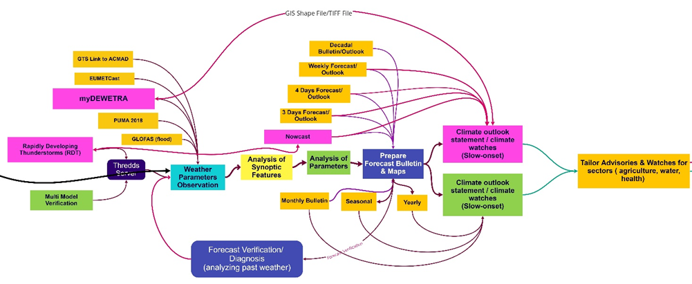
Figure: Multi-hazard advisories and watches development
Step 1: Data Acquisition – Weather Parameter Observations
In the initial phase, forecasters are responsible for gathering real-time atmospheric observations from all available monitoring systems. This includes:
1.1 Accessing Multi-Source Observation Tools
Forecasters must systematically access and review the full suite of observational tools, including:
- Satellite-based nowcasting interfaces
- Geostationary and polar-orbiting imagery
- Lightning detection networks
- Rapidly Developing Thunderstorm (RDT) products
- PUMA, EUMETCast, HimawariCast, and other satellite downlink data
- Ground-based synoptic observations (SYNOP, METAR, AWS)
These tools collectively offer a comprehensive view of current weather conditions, atmospheric instability, moisture distribution, and convective development.
1.2 Rapidly Developing Weather Events
For fast-evolving severe weather, forecasters must:
- Closely examine the RDT interface for convective initiation, storm cell growth, decay, and movement.
- Monitor cloud-top cooling rates, lightning frequency, and vertical cloud structure.
- Assess potential consequences such as heavy rainfall, flash floods, severe winds, or hailstorms.
Once interpreted, forecasters issue nowcasts and short-term warnings based on these rapid diagnostics.
Step 2: Processing and Analysis of Synoptic Features
After initial data gathering, forecasters must analyze synoptic-scale weather patterns to understand regional atmospheric dynamics.
2.1 Satellite–Synoptic Integration
Forecasters perform concurrent analysis by combining:
- Satellite imagery
- Upper-air and surface observations
- Synoptic charts (pressure patterns, fronts, troughs, ridges)
- Past 24–48 hour weather evolution
2.2 Diagnosing System Evolution
Key aspects include evaluating whether:
- A convective system is intensifying, decaying, or migrating
- Moisture advection and convergence zones are strengthening
- Wind shear supports or inhibits storm development
2.3 Use of PUMA and GIS-Based Platforms
Forecasters regularly use PUMA stations for synoptic chart interpretation.
The integrated geospatial forecasting platform enhances analysis by enabling:
- Overlay of synoptic features on GIS layers
- Spatial interrogation of weather systems with terrain, land cover, and vulnerability attributes
This strengthens situational awareness and supports location-specific forecasting.
Step 3: Analysis of All Atmospheric Parameters and Indices
A thorough investigation of atmospheric stability, dynamics, and thermodynamics is essential for reliable forecasting.
3.1 Critical Synoptic Drivers
Forecasters must analyze key parameters such as:
- Inter-Tropical Discontinuity (ITD) position and movement
- Monsoon flux and cross-equatorial flow patterns
- Southward moist-air advection vs. northward dry-air intrusion
- Deep convection zones south of ITD during the West African Monsoon
3.2 Thermodynamic and Dynamic Indices
Essential indices include:
- CAPE (Convective Available Potential Energy) – measures atmospheric instability
- Lifted Index (LI) – provides insights into thunderstorm potential
- Wind velocity and direction at multiple levels
- Upper-level divergence and lower-level convergence signals
- Relative humidity profiles (surface to mid-troposphere)
- Wet-bulb potential temperature, dew point, and moisture flux
3.3 Integrated Hazard Interpretation
These parameters help forecasters diagnose:
- Potential for thunderstorms, torrential rainfall, flash floods
- Cyclogenesis or tropical wave intensification
- Heat stress conditions
- Severe winds and dust outbreaks
This step forms the analytical backbone for all subsequent forecast products.
Step 4: Preparation of Forecast Maps, Bulletins, and Advisories
After thoroughly analyzing atmospheric and synoptic features, forecasters prepare a comprehensive set of forecasting outputs.
4.1 Developing Multi-Temporal Forecast Products
Forecasters must construct:
- Nowcasts (0–6 hours)
- Short-range forecasts (daily)
- Medium-range forecasts (3–7 days)
- Extended-range outlooks (2 weeks and beyond)
4.2 Creating Operational Forecast Maps
Using geospatial tools, forecasters generate maps that depict:
- Expected rainfall intensities
- Thunderstorm zones
- Wind speed/direction forecasts
- Temperature extremes
- Multi-hazard hotspots
4.3 Issuing Watches, Advisories, and Outlooks
These products must clearly communicate:
- Areas at risk
- Expected severity
- Likelihood and timing of the event
- Recommended actions (if applicable)
All products must follow ACMAD’s standardized templates and communication protocols.
Step 5: Preparing Tailored Sectoral Advisories and Multi-Hazard Maps Using GIS Tools
5.1 Role of Disaster Risk Management (DRM) Professionals
This step is typically led by DRM experts who interpret meteorological outputs in relation to:
- Exposure data (population, settlements, infrastructure)
- Vulnerability layers (poverty, food security, agriculture zones)
- Sector-specific sensitivities (health, transport, water resources)
5.2 GIS-Based Multi-Hazard Analysis
Using GIS platforms (ArcGIS, QGIS, etc.), professionals overlay:
- Hazard layers
- Exposure layers
- Vulnerability indicators
This integrated mapping approach generates:
- Comprehensive Multi-Hazard Exposure Maps
- Risk and Vulnerability Profiles
- Sector-Specific Impact Maps
5.3 Final Products for Decision-Making
The result is a suite of decision-support tools used by:
- National and local disaster management authorities
- Humanitarian agencies
- Sector ministries
- Community-based organizations
These products guide preparedness, emergency response, resource allocation, and recovery planning.
This enhanced five-step methodology ensures that ACMAD’s forecasting operations are: Scientifically robust, Multi-layered, Integrated across meteorological and Disaster Risk Mangment workflows, Optimized for impact-based early warning, It strengthens ACMAD’s ability to produce timely, actionable, and user-centered forecasts, ultimately protecting lives, livelihoods, sectors, vulnerable communities and risk management stakeholders on the national and local level, .and development gains across Africa.
6.2 Types of Products
1. Short-Range Forecasting (Nowcasting, Daily, Weekly)
Short-range forecasts cover 12 hours to a few days and focus on rapidly evolving weather systems. Key products include:
- Heavy rainfall and localized rainfall surges
- Strong winds and severe wind gusts
- Floods and flash floods
- Tropical cyclones and associated hazards
- Rapid-onset convective events
- Rapidly Developing Thunderstorm (RDT) detection and monitoring
These products are reinforced by real-time satellite observations, radar (where available), NWP model guidance, and nowcasting tools.
2. Medium-Range Forecasting (A Few Days to Two Weeks)
Medium-range forecasts (up to 14 days) provide early insight into evolving hazard conditions. Key elements include:
- Flood and flash flood potential
- Strong wind events
- Tropical cyclone track/intensity guidance
- Persistent rainfall systems
- Indications of multi-hazard risk interactions (e.g., saturated soils + heavy rainfall)
These forecasts blend multi-model ensembles, synoptic analysis, and probabilistic hazard assessments.
3. Extended-Range Forecasting (Two Weeks and Beyond)
Extended-range forecasts (beyond two weeks) support climate-sensitive planning and early warning for slow-onset and large-scale hazards. Products include:
- Multi-hazard forecasts and risk maps for:
- Heavy rainfall
- Strong winds
- High temperatures and heatwaves
- Localized thunderstorms
- Drought onset and intensification
- Severe weather anomalies
- Multi-hazard bulletins highlighting potential impacts
- Analysis of atmospheric drivers influencing extended outlooks
Extended-range forecasts provide decision-makers with early insight into hazard probabilities and emerging risk hotspots.
4. Monthly and Seasonal Forecasting
Monthly and seasonal forecasts continue to improve through enhanced model skill, multi-model ensembles, and improved data assimilation. Key products include:
- Monthly and seasonal precipitation forecasts
- Seasonal temperature anomaly maps
- African seasonal precipitation average maps
- Seasonal rainfall variability and extremes
- Drought outlook and agricultural drought risk assessment
- Monthly Climate Diagnostic Bulletin for Africa (RCC)
- Multi-hazard maps for development sectors (agriculture, water, energy, health, DRM)
- Customized sector-specific early warning maps and climate risk products
These forecasts provide essential information for medium- to long-term planning.
5. Long-Range Forecasting (Seasonal to Annual and Beyond)
Long-range forecasts extend to multiple seasons and annual outlooks, offering strategic climate insights. Products include:
- Seasonal climate forecast bulletins (RCC)
- Seasonal precipitation and temperature anomaly forecasts
- Long-term multi-hazard forecast maps
- Seasonal variability of rainfall, storms, heatwaves, and other climate drivers
- Customized climate-risk products for development planning and policy formulation
6. Numerical Weather Prediction (NWP) and Derived Products
ACMAD uses NWP model outputs to refine short-, medium-, and long-range forecasts. Key outputs include:
- D1, D2, and D3 rainfall accumulation forecasts
- ITD (Inter-Tropical Discontinuity) position forecasts (D1 to D3)
- Multi-model rainfall, wind, temperature, and pressure outlooks
- Specialized convective and severe weather indices
These NWP outputs underpin operational forecasting accuracy at multiple timescales.
7. Rapid-Onset Hazard Forecasting
Specialized attention is given to rapid-onset hazards, such as:
- Rapidly Developing Thunderstorms (RDT)
- Sudden severe windstorms
- Flash flood triggers
- Localized extreme rainfall bursts
These events rely heavily on real-time monitoring, satellite-based nowcasting, and automated hazard detection systems.

Figure 2: Proposed linkages among the WMO Regional Specialized Meteorological Centers
Strengthening coordination mechanisms among the WMO-designated Regional Specialized Meteorological Centers (RSMCs) and Regional Climate Centers (RCCs) across the African continent is essential for optimizing the use of meteorological resources and expertise. Enhanced collaboration will improve access to high-quality weather and climate datasets, information products, forecasting tools, and scientific knowledge.
As a continental hub, ACMAD is well positioned to play a pivotal leadership role in fostering these linkages. By establishing structured partnerships and data-sharing arrangements with RSMCs and RCCs, ACMAD can enhance the accuracy, precision, and reliability of key meteorological services, including:
- Severe weather warnings
- Short-, medium-, and long-range forecasts
- Climate outlooks and diagnostic analyses
- Impact-based multi-hazard early warnings
These strengthened regional connections will create a more integrated continental forecasting ecosystem, enabling harmonized services, improved early warning dissemination, and better-informed decision-making for Member States.
7.4 Way forward:
1. Operational Multi-Hazard Situation Room
A fully functional situation room will support real-time data capture, processing, and the production of customized early warning and risk-informed decision-support products. Interactive dissemination channels will ensure timely communication of warnings and services.
2. Deployment of customized forecast preparation and dissemination Platform
The ACMAD needs to develop its own geospatial platform system, enabling advanced processing and customization of multi-hazard risk, vulnerability, and exposure analyses.
- It integrates high-resolution geospatial and hydrometeorological data.
- It supports deeper risk assessments through compatibility with GIS and analytical tools (ArcGIS, QGIS, R, surfer, netCDF, MATLAB, Genstat, etc.).
- It enables precision-level MHEWS operations.
3. Strengthening Coordination and Data Exchange
A comprehensive, two-way coordination mechanism will be established across multiple layers:
AUC (ACMAD/ICPAC) ⇄ Regional Economic Communities (RECs) ⇄ Member States ⇄ NHMS ⇄ Government sector departments ⇄ Local governments ⇄ Vulnerable communities.
This enables timely data sharing, collaborative risk analysis, and harmonized early warning actions.
4. Engagement with Media and Communication Channels
Partnerships with national media, news agencies, and community radio stations will support widespread dissemination of risk and early warning information.
5. Integration with National HMHS and WMO Centers
National Hydro-Meteorological and Hydrological Services (NHMS) will be engaged to analyze extreme weather risks and support AUC-led coordination.
Linkages with WMO-designated regional centers will ensure access to specialized, region-specific weather data and products.
6. Upgrading ACMAD to a Full Impact-Based Early Warning Hub
ACMAD’s Regional Climate Center (RCC) will evolve into an impact-based multi-hazard early warning situation room, addressing existing gaps in impact-based forecasting.
The upgraded center will connect seamlessly with:
- AUC’s Emergency Operations Center (EOC)
- ICPAC
- RECs
- AU sub-organs
- Member State situation rooms
- Other regional and international early warning systems
For complete documents – Please email at : zmsajjad@yahoo.com