Indonesian National Board for Disaster Management(BNPB)

Badan Nasional Penanggulangan Bencana
Indonesian National Board for Disaster Management(BNPB)was established in 2008 to replace the Indonesian National Disaster Management Coordination Committee, which was established in 1979. It is responsible for protecting the nation from the threat of disasters through risk reduction and building a reliable system of disaster management.It is also responsible for issuing periodic information on Indonesian volcanic conditions. In the announcement of these information, it will learn from the Indonesian volcanic disaster prevention center recommendations. As of September 2011, Indonesia five volcanoes are three “alarm” state.
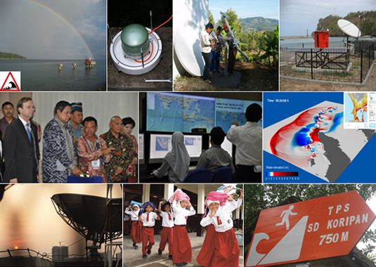
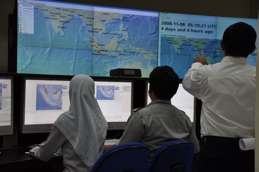
Thanks to the Indonesian Government for significant progress in deploying the real-time Disaster Alert System with sensor-based data ingestion to geospatial technologies…. followings are the snapshots ;
The Indonesian Disaster Information Data (DIBI)

The Indonesian Disaster Information Data (DIBI) contains data on more than 50,000 disaster events from 1815 (the eruption of Mount Tambora) to the present, along with their impacts. This database is intended to serve the need for disaster-related data; both to support humanitarian action during emergency response, post-disaster rehabilitation and reconstruction efforts, and disaster risk reduction. Thus, decision-making and policymaking are always data-driven. This site allows visitors to explore the DIBI dataset using dashboards and charts (tables, graphs, and maps) based on Apache Superset as a business intelligence (BI) tool. This page is an example of a Superset dashboard with several charts for data visualization. Various chart options are available for data visualization; in addition, visitors can also filter and download data in each chart. For further details on how to use the dashboard, please refer to the usage documentation available at the bottom of this page.
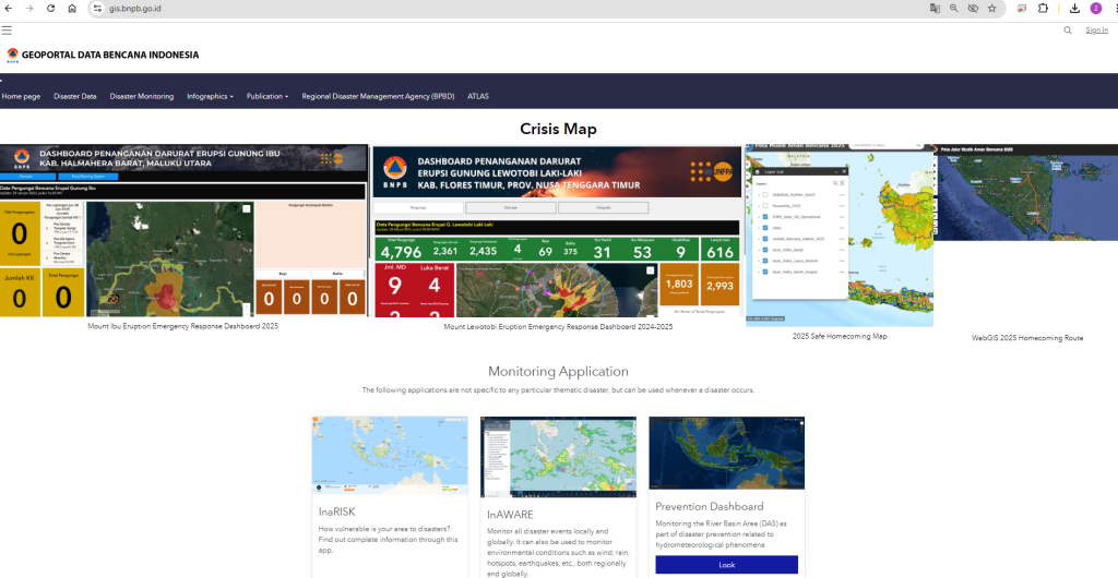
Indonesia initiated the Multi-hazard Risk Tracking, Hazard Profiling Geospatial Portal


About InaRISK
InaRISK is a risk study results portal that uses ArcGIS server as data services that describe the scope of disaster threat areas, affected populations, potential physical losses (Rp.), potential economic losses (Rp.) and potential environmental damage (ha) and is integrated with the realization of disaster risk reduction activities as a monitoring tool for reducing the disaster risk index.
The contribution made by the United Nations Development Program (UNDP) is to prepare data services which are the main data in InaRISK.
Mapping of cultural heritage sites in the Provinces of DIY and Central Java for the development of InaRISK is a contribution from UNESCO (United Nations Educational, Scientific, and Cultural Organization) in partnership with BNPB, UGM, PT. Waindo SpecTerra, BPCB Prov. DIY, BPCB Prov. Central Java and the Ministry of Education and Culture.
InaRISKIt was officially launched by the Head of the National Disaster Management Agency (BNPB) on November 10, 2016, which was also attended by Ministries/Institutions, representatives from UN Agencies, representatives of organizations from other donor countries (NGOs) and other related government institutions.
It is hoped that InaRISK can be used by all parties, including the community, in preparing disaster management plans and apart from being a portal for sharing spatial data in the form of GIS services, it is as follows:
- A tool for disseminating the results of disaster risk studies to the Government, Regional Governments, and other stakeholders as a basis for planning disaster risk reduction programs.
- Assisting the Government, Regional Governments, and other parties in developing strategies for implementing programs, policies, and activities to reduce disaster risks at the national to regional levels.
- Assisting the Government in monitoring the achievement of disaster risk index reduction in Indonesia.
- Providing spatial data for other analysis purposes, such as GCDS (Global Center Disaster Statistics) , MHEWS , spatial planning revisions , etc.
The InaRISK Online Application itself was developed with free software products:
- NodeJSNode.js® is a JavaScript runtime built on the V8 engine developed by Google. It uses non-blocking I/O, making it lightweight and efficient. The Node.js module package, NPM (Node Package Manager), is the world’s largest module ecosystem of open-source libraries. Node.js is designed for building network applications that are easy to scale, extend, and replicate.
- PostgreSQLPostgreSQL is a powerful, open-source relational database system. It has over 15 years of active development and a proven architecture that has a strong reputation for reliability and data integrity. PostgreSQL runs on all major operating systems, including Linux, UNIX (AIX, BSD, HP-UX, SGI IRIX, macOS, Solaris, Tru64), and Windows.
- D3JSD3.js is a JavaScript library for data-driven document manipulation. It helps represent data in HTML, SVG, and CSS. It combines powerful visualization components and a data-driven approach to DOM (Document Object Model) manipulation.
https://gis.bnpb.go.id/

The Geospatial Dashboard – profiles of disaster incidence tracking data with Loss and Damage & impact information. The portal useful for Multi-hazard and disaster crisis management
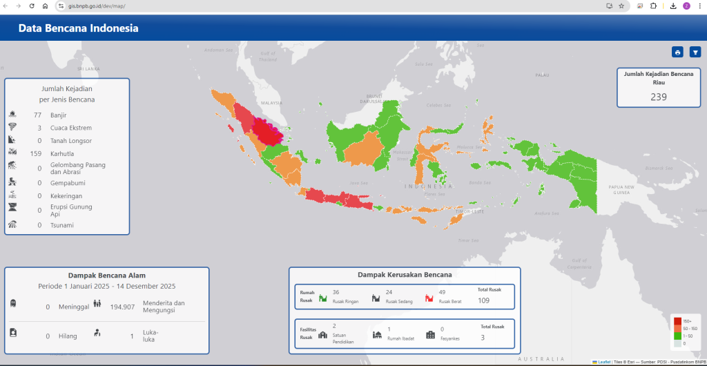
https://gis.bnpb.go.id/databencana/tabel/pencarian.php
The Disaster Prevention Dashboard
The Disaster Prevention Dashboard is a disaster portal that compiles various fluvial flood hazard predictions based on data and information processing outputs from various ministries and institutions . The Dashboard was developed in 2021 with the primary objective of providing early warning information on flood hazards to stakeholders (local governments and the public) so they can take early action to mitigate the negative impacts of flood disasters. The data and information available in the prevention dashboard are supported by relevant authorized ministries/institutions with the competence to provide support related to early warning of flood hazards. The Dashboard development also references the SNI 8840-3:2022 DISASTER EARLY WARNING SYSTEM guide .

Currently available information services include:
- “Flood Hazard Prediction Reanalysis” at the sub-district level based on the output of impact-based weather forecast data from “Signature – BMKG” and flood early warning data for river areas from “Flood Task Force – PUPR” (Daily data updates every 07.00 WIB, 14.00 WIB, and 17.00 WIB)
- Monitoring of “River Water Level Status” from “Sihka – PUPR” (Daily data updates every 1 hour)
- “Flood Risk” information includes risk area (ha), number of people exposed (people), physical and economic losses (Rp), and environment (ha) from “Inarisk – BNPB” (Data updated every 3 years)
- Information on the percentage of “Land Cover” in 2017, 2018, 2019 from “SIGAP -KLHK” (Data updated every 1 year)
- Information on “Water Level Status and Water Travel Time” in the Bengawan Solo River Basin from “BBWS Bengawan Solo” (Daily data updates every 1 hour)
- Information on flood incidents reported through reports from the large river basin office and Twitter processed by “Simadu – PUPR” (Daily data updates every 1 hour)
- “BMKG Radar Observation” Information (Daily updates every 1 hour)
The output information of “Flood Hazard Prediction Reanalysis” can be downloaded ( map and shapefile ) and shared via open source messaging platforms such as WhatsApp and Telegram.
- A list of locations that have water level observation points can be seen at the following link: Water Level Post
- 1. REANALISIS
The prevention dashboard provides predictive information related to flood hazards in two main formats. First, predictive information is based on Ministry/Institutional Output (BMKG Signature & PUPR Flood Task Force). Second, reanalysis is conducted based on spatial analysis utilizing BMKG Signature Data output and PUPR Flood Task Force. A pilot in-depth analysis was conducted in the Bengawan Solo Watershed area, utilizing various meteorological and hydrological information available at https://hidrologi.bbws-bsolo.net/ through an integration and interoperability scheme.
Interpretations of the figures in the early warning tabulation include:
- 1. Alert (There is early warning information on weather impacts based on the output of the “BMKG Signature”)
- 2. Alert (There is early warning information on weather impacts based on the output of “BMKG Signature” and early warnings based on river areas with the category “Flood Prone” based on the output of “Flood Task Force – PUPR”)
- 3. Warning (There is early warning information on weather impacts based on the output of “BMKG Signature” and early warnings based on river areas with the category “Flood Prone” based on the output of “Flood Task Force – PUPR” and/or confirmed flooding incidents based on reports received by “SImadu – PUPR”).
Rainfall forecast data (mm), radar observation data (mm), and water level status observations are only available within the “Reanalysis” area .
Information regarding the PUPR Flood Task Force and SIMADU PUPR can be downloaded on the following page:
Funding for the development of the Prevention Dashboard comes from the APBN under the Upstream coordination, Early Warning Directorate, Prevention Deputy, National Disaster Management Agency.
Early Warning Directorate
National Board for Disaster Management
Graha BNPB Building, 6th Floor, Jalan Pramuka no. 36, East Jakarta
Telephone (021 – 29827793)
Fax (021 – 281200)
Help Desk (+62 822-9900-7794)
InAWARE – web-based Decision Support System (DSS) for use by disaster managers at national and provincial levels.
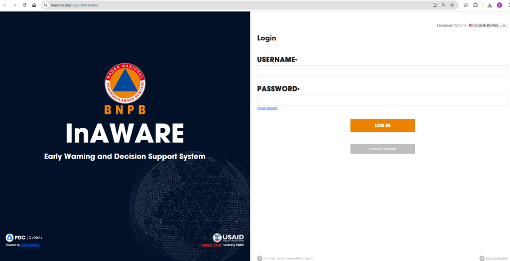
InAWARE Project Summary
Under funding from the U.S. Agency for International Development (USAID) Office for Foreign Disaster Assistance (OFDA), Pacific Disaster Center (PDC) is providing Technical Assistance to the Government of Indonesia’s National Agency for Disaster Management (BNPB) to improve early warning and disaster management decision making outcomes. The project provides a web-based Decision Support System (DSS) for use by disaster managers at national and provincial levels.
Project funded by USAID/BHA (Award No. 720FDA19GR00018), USAID/OFDA (Award No. G-13-00058) and INVEST DM sub-award (Award No. 720BHA21CA00013).


InAWARE Current Version
Powered by DisasterAWARE version 8.2
For a complete set of release notes, visit https://disasteraware.org/releasenotes.
User Access and Restrictions
This is a protected site maintained by BNPB for the disaster management community. Access to this website requires registration and approval. For questions, help or to request access to InAWARE, please email inaware@bnpb.go.id.
Drought on Java Island
The 2023 drought on Java Island was first reported in May in several areas in Cilacap and Bogor Regencies. Previously, the BMKG (Meteorology, Climatology, and Geophysics Agency) predicted that El Niño, a warming phenomenon in the central and eastern tropical Pacific Ocean, would begin in June, with widespread drought impacts in July. In June, the number of drought events increased (13 reported) and further increased in July and August, with a total of 34 reported events. This had been previously predicted by the BMKG, which stated that the peak of the dry season would occur in August.

According to the Risk and Hazard Map of drought-affected areas on Java, taken from InaRisk, most areas on Java, especially those affected by the drought, fall into the moderate to high risk and hazard index categories. Coupled with the El Niño impact on Java, there’s a high likelihood of drought in some areas.

In August 2023, drought hit several areas on the island of Java, including Serang City in Banten Province. In West Java Province, including Sukabumi Regency, Bogor Regency, Bekasi Regency, Subang Regency, Sukabumi City, Garut Regency, Ciamis Regency, and Cirebon Regency. In Central Java, drought also hit a number of areas including Tegal Regency, Banyumas Regency, Cilacap Regency, Purworejo Regency, Magelang Regency, Temanggung Regency, Batang Regency, Kendal Regency, Semarang City, Semarang Regency, Grobogan Regency, Blora Regency, Sragen Regency, Klaten Regency. Meanwhile in East Java, drought hit the Pamekasan area, Situbondo Regency, Bondowoso Regency, and Jember Regency. The Special Region of Yogyakarta also experienced drought in Gunung Kidul Regency.

In addition to having moderate to high risk and hazard indices, El Niño plays a significant role in Java’s extremely low rainfall. Based on the Monitoring of Consecutive Rainless Days issued by the Meteorology, Climatology, and Geophysics Agency (BMKG), some areas on Java Island experienced long to extremely long rainless days. El Niño is the cause of the long number of rainless days on Java Island, resulting in little to no rainfall. This extremely low rainfall reduces water supplies, resulting in drought in various regions.

source: BMKG
Over the past five years, Java has experienced a fluctuating trend in drought events. Over the past five years, 2018 was the year with the highest number of disasters, with 130 incidents. Droughts decreased slightly in 2019, with 123 drought incidents on Java. Droughts decreased significantly in 2020, with only 26 incidents in that year. Droughts continued to decline through 2022, with 15 drought incidents in 2021 and 4 in 2022. National Disaster Management Agency (BNPB) data as of August recorded a significant increase in drought incidents in 2023, with 49 incidents.

Trends in drought disaster events on Java Island (2018-2023*)
According to the graph of affected victims, which depicts the number of victims affected and displaced by the drought disaster on Java Island, it can be seen that the number of affected victims is directly proportional to the number of incidents in that year. In 2018, with the highest number of incidents in the last five years, resulting in the highest number of affected and displaced victims with 7,798,763 people. The number of affected and displaced people decreased in 2019 with 3,872,358 people. Victims continued to decrease from year to year, in 2020 as many as 1,607,870, as many as 95,207 in 2021. In 2022, the number of affected and displaced victims due to the drought disaster on Java Island became the year with the lowest impact with 13,231 people. Victims increased again in 2023 with 428,749 people affected and displaced.

Graph of victims affected and displaced due to drought disaster on Java Island (2018-2023*)
The impact of drought not only affects humans but also affects rice fields and gardens. In 2018, 16,189 hectares of gardens were affected by drought on Java. In 2019, drought affected 22,315 hectares of rice fields. From 2020 to 2022, no rice fields or gardens were recorded as being affected by drought on Java. In 2023, data from August recorded 980 hectares of rice fields and 22 hectares of gardens affected by drought.

Drought disaster graph per province on Java Island in 2023
As of August 27, 2023, drought had hit five of the six provinces on Java Island. Central Java, with the highest number of droughts this year, experienced 24 droughts, affecting 54,012 people. West Java was in second place with 18 droughts, affecting 106,005 people. East Java, with five droughts, had the highest number of affected people, with 223,272 people. Banten only experienced one drought, affecting 2,304 people. The Special Region of Yogyakarta also experienced one drought, affecting 43,156 people. Meanwhile, Jakarta did not experience any drought this year.
Drought Monitoring in West Java
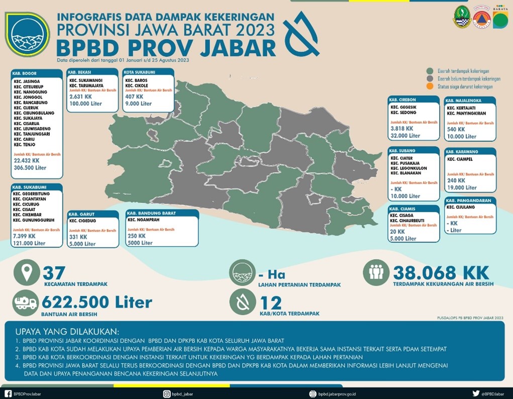
In West Java, 38,068 families were affected by drought spread across 12 regencies and cities and 37 sub-districts. Efforts made by the West Java Provincial BPBD include coordinating with the BPBD and DPKPB of regencies/cities throughout West Java. The regencies/cities BPBD has made efforts to provide clean water to residents in collaboration with related agencies and the local PDAM. The amount of water that has been distributed is 622,500 liters. The regencies/cities BPBD also coordinated with related agencies regarding the impact of drought on agricultural land. In addition, the regencies/cities BPBD continues to coordinate in providing further information and data collection in future drought management.
Drought Monitoring in Central Java

Summary graph of the number of villages affected by drought in regencies/cities in Central Java in 2023
According to data from the Central Java Regional Disaster Management Agency (BPBD), 414 villages were affected by drought in Central Java Province. These villages are spread across 29 regencies and cities, namely 30 villages in Cilacap Regency, 14 villages in Banyumas, 12 villages in Purbalingga, 11 villages in Banjarnegara, 3 villages in Kebumen, 10 villages in Purworejo, 10 villages in Magelang, 13 in Boyolali, 10 villages in Klaten, 2 villages in Sidoarjo, 16 villages in Sragen, 71 villages in Grobogan, Blora with 87 villages being the most drought-affected areas in Central Java. Furthermore, 7 villages in Rembang, 28 villages in Pati, 1 village in Kudus, 2 villages in Jepara, 18 villages in Demak, 7 villages in Kab. Semarang, 10 villages in Temanggung, 1 village in Kendal, 1 village in Batang, 4 villages in Pekalongan, 13 villages in Pemalang, 10 villages in Tegal Regency, 9 villages in Brebes, 4 villages in Salatiga City, 7 villages in Semarang City, and 3 villages in Tegal City.

A total of 12,970,300 liters of water have been distributed in various regencies and cities affected by drought in Central Java Province. The regencies and cities targeted for water distribution include Cilacap Regency, Banyumas Regency, Purbalingga Regency, Banjarnegara Regency, Kebumen Regency, Purworejo Regency, Magelang Regency, Boyolali Regency, Klaten Regency, Sukoharjo Regency, Sragen Regency, Grobogan Regency, Blora Regency, Rembang Regency, Pati Regency, Kudus Regency, Jepara Regency, Demak Regency, Semarang Regency, Temanggung Regency, Kendal Regency, Batang Regency, Pekalongan Regency, Pemalang Regency, Tegal Regency, Brebes Regency, Salatiga City, Semarang City, Salatiga City.
Drought Monitoring in East Java

To address the impact of the drought, East Java Province has sent clean water assistance to 19 regencies and cities. These regencies and cities include Tuban Regency, Bojonegoro Regency, Ponorogo Regency, Nganjuk Regency, Trenggalek Regency, Tulungagung Regency, Blitar Regency, Gresik Regency, Mojokerto Regency, Lamongan Regency, Pasuruan Regency, Probolinggo Regency, Bangkalan Regency, Sampang Regency, Pamekasan Regency, Situbondo Regency, Bondowoso Regency, Jember Regency, and Sumenep Regency.
BNPB’s efforts to overcome drought on Java Island
In an effort to address the drought disaster during the 2023 dry season, the National Disaster Management Agency (BNPB) urged residents to improve the environment by planting trees, building or rehabilitating irrigation networks, conserving water, and protecting available clean water sources. BNPB, together with the Regional Disaster Management Agency (BPBD), distributed clean water in several drought-affected areas on Java Island. In addition to drought, this year’s dry season could trigger forest and land fires (karhutla). BNPB, through its air task force, implemented Weather Modification Technology (TMC) in several areas prone to forest and land fires. BNPB deployed two helicopters for patrols and three helicopters for water bombing with a capacity of 4,000 liters of water. In addition to forest and land fires, drought also causes air pollution, such as in Jakarta. BNPB, together with the Indonesian National Armed Forces (TNI), the National Agency for Research and Innovation (BRIN), and the Meteorology, Climatology, and Geophysics Agency (BMKG), implemented Weather Modification Technology (TMC) to induce rain to reduce air pollution in Jakarta. To reduce air pollution on land, the National Police and Fire Department sprayed water on the roads.
Indian Ocean Tsunami Information Centre
The Indian Ocean Tsunami Information Centre (IOTIC) supports the member states of the UNESCO-IOC Intergovernmental Coordination Group for the Indian Ocean Tsunami Warning and Mitigation System (ICG/IOTWMS) in reducing tsunami risks by engaging with Member States stakeholders, the general public, and at-risk communities across the Indian Ocean.
About InaTSP
Introduction
During the ICG meeting in Mombassa, Kenya 28 February – 2 March 2007, the National Tsunami Warning Centre (NTWC) of Indonesia proposed to provide alert services to the member states of IOTWS as one of Tsunami Watch Provider (TSPs) along with India, Australia, Malaysia, Thailand and Iran. We have been working together under the coordination of IOC/ICG-UNESCO in the group of IOTWS starting with the arrangement of requirements, interoperability schedule of work and finally looking at the implementation. While we worked at the implementation, PTWC and JMA voluntarily provided the service to all NTWCs in Indian Ocean Region as an Interim Advisory Service (IAS). In that period of time, TSPs shadow the operation of IAS and provided service level 1 (earthquake information) until RTSPs are ready to provide full services of level 1 and 2.
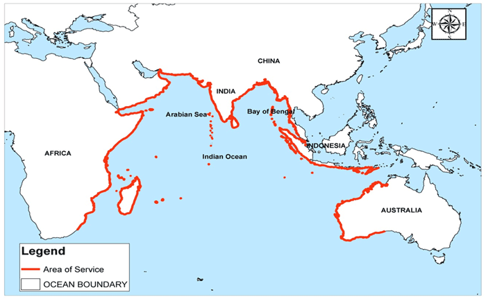
Figure 1. Area of Responsibility of TSP
The progress of implementation has been reported by TSPs in every meeting, mainly in ICG meetings. The agreement has been met at ICG meeting that in the year 2011, TSPs of Australia, India and Indonesia are ready to provide service level 2. However, all TSPs are requested to provide a guideline of TSP products for NTWC as a reference to NTWC decision making in case of a tsunami threat.
TSP of Indonesia is operated by BMKG (the Agency for Meteorology Climatology and Geophysics) the leading institution and in charge of operating InaTEWS (Indonesia Tsunami early Warning System) in cooperation with BAKOSURTANAL and BPPT. The monitoring systems consist of seismic, tide gauge, GPS and Buoy networks, operated by BMKG, BAKOSURTANAL (National Coordinating Agency for Survey and Mapping) and BPPT (Agency for Assessment and Application of Technology), respectively. All data are transmitted in real-time or near real-time to BMKG which is operating of InaTEWS for the purpose of forecasting tsunami hazard analysis and warning dissemination.
InaTSP Dissemination Diagram
The TSP products are delivered through a number of communications media. Notification messages are sent to NTWCs when TSP bulletins are issued, via WMO Global Telecommunication System (GTS), e-mail, SMS and fax. The notification messages do not contain bulletin content, since the information is not intended for public dissemination.
Notification messages distributed through the GTS require identifiers in a specific format. For tsunami messages in the Indian Ocean the defined identifier is WEIO22.
TSP bulletins with detailed threat information will be distributed to NTWCs and will be available on password-protected websites maintained by each TSP.
Maps and other graphical representation of TSP information may be made available to NTWCs on password-protected websites maintained by each TSP. Examples of TSP-Indonesia’s web pages for NTWC use are shown in Appendix 3.
Anymore detailed country-specific information or products must be arranged through bilateral agreement between the country requiring the service and an individual TSP.
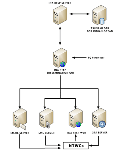
Figure 2. InaTSP Dissemination Diagram
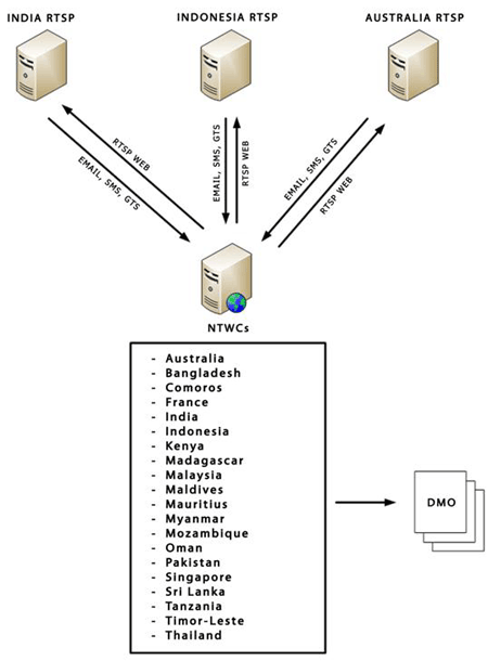
Figure 3. Dissemination System from TSPs & NTWCs Perspective
InaRTSP Bulletins for NTWCs
TSP-Indonesia will issue bulletin when an earthquake of magnitude 6.5 or greater (Mwp) is detected under the sea in ASEAN countries, Nicobar Islands and Papua New Guinea (PNG), or Pacific Ocean. The ICG-IOTEWS has agreed that all RTSPs will provide the following four types of Bulletin for National Tsunami warning Centres:
- Bulletins providing details of undersea earthquakes of magnitude 6.5 or greater (Mwp) (referred to as Bulletin type 1)
- Bulletins providing an initial forecast of tsunami threat, including details such as ETA and ETH for each coastal forecast zones under the threat (referred to as Bulletin type 2).
- Bulletins providing update forecasts of tsunami threat, plus information on observed sea-level anomalies (referred to as Bulletin type 3)
- Bulletins providing information on the finalization of the tsunami threat (referred to as Bulletin type 4)
The specific information contained in each type of bulletin comprises of:
Bulletin type 1 – Earthquake Bulletin
Bulletin type 2 – Tsunami Forecast
Bulletin type 3 – Tsunami Forecast and Observations
Bulletin type 4 – Tsunami Service Finalization
for detail information about this bulletin type see: TSP Indonesia user manual
TSP Public Bulletins
The above products for NTWCs are not intended for public dissemination. Public products from TSPs will be limited to earthquake parameters and summaries of warnings issued by NTWCs around the Indian Ocean during tsunami event. These summaries will be collated from information provided by NTWCs, and will be made available on an Indian Ocean warning summary webpage.
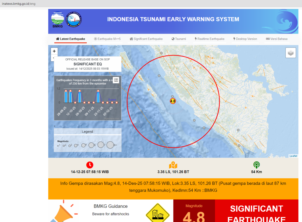
Public information on tsunami events in the Indian Ocean will be restricted to earthquake details, sea-level observation and a summary of national warning status (as advised by NTWCs to RTSP Indonesia). This information will be available at: http://rtsp.bmkg.go.id , click on InaTSP Public
| ATIONAL SEISMIC NETWORK USED BY TSP INDONESIA |
  |
Origins
As part of the international mandate for increased tsunami safety that followed the tragic 2004 Indian Ocean tsunami, UNESCO-IOC set up the Jakarta Tsunami Information Centre (JTIC) with funding from Canada to provide information on tsunamis. In 2012, JTIC was asked to become the Indian Ocean Tsunami Information Centre (IOTIC), a change approved in 2015.
In 2017, UNESCO-IOC and the Indonesian Government, through BMKG, started the IOTIC-BMKG Programme to support IOTIC’s work. This partnership was renewed in 2022 for another five years. IOTIC is in the UNESCO Office in Jakarta, and the IOTIC-BMKG Programme office is at BMKG.
As a Tsunami Service Provider (TSP) for the Indian Ocean Countries, the Indonesian Tsunami Early Warning System (InaTEWS) offers web access to ocean-wide tsunami warning products.
Registered users may login in order to access warning bulletins issued by TSP Indonesia.
New dissemination mode from TSP Indonesia to NTWCs 
WRS-TSP Indonesia (stands for Warning Receiver System of TSP Indonesia) is the real-time system dedicated to receive earthquake information and tsunami bulletin from TSP Indonesia. WRS-TSP Indonesia connected online directly to the processing and dissemination system of TSP Indonesia at BMKG Jakarta head quarter. WRS-TSP Indonesia is the best solution that can be used as complement or even replacement of existing conventional (SMS, email, fax, GTS) dissemination tool of TSPs. This system use the most current advance technology to distribute information in real-time.
This system is very well displayed on a large screen in the operational room of NTWCs. WRS-TSP Indonesia ensures NTWCs of the Indian Ocean Countries keep informed tsunami bulletin timely and properly. Tsunami bulletin is now in your desk !!. NTWCs could immediately take further essential actions right after they received the tsunami bulletin.

WRS-TSP Indonesia Features
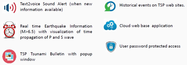
Click here to get user guide of WRS-TSP Indonesia.
The InaTEWS-BMKG functions as an approved Tsunami Service Provider of the IOTWMS that is an integral part of the Global Tsunami Warning and Mitigation System, established and coordinated by the Intergovernmental Oceanographic Commission (IOC) of UNESCO.
Tsunami Programme of IOC-UNESCO
The Tsunami Programme of IOC-UNESCO (http://www.ioc-tsunami.org/), through the coordination of regional meetings, capacity building activities and support of national and regional projects is a key stakeholder for tsunami risk reduction at the global level.
Four Intergovernmental Coordination Groups (ICGs) corresponding to the Pacific Ocean, Caribbean Sea, Indian Ocean, and Northeast Atlantic Ocean & Mediterranean Sea have been established by IOC-UNESCO to address particular regional needs.
Further, to advise the IOC governing bodies on coordinated development of warning and mitigation system for tsunamis and other hazards related to sea level that are of common interest to all the ICGs, the IOC Assembly at it 24th Session (Resolution XXIV-14) established a Working Group on Tsunamis and Other Hazards Related to Sea-Level Warning and Mitigation Systems (TOWS-WG).
Tsunami Warning Service Framework
The end-to-end tsunami early warning and mitigation system consists of Risk Assessment & Reduction, Detection, Warning & Dissemination, and Awareness & Response.
Regional tsunami warning systems operating within different ocean basins are the building blocks of the end-to-end tsunami warning and mitigation system, coordinated by IOC-UNESCO as a global system of systems.
The service framework within each regional tsunami warning system ideally is comprised of National Tsunami Warning Centres (NTWCs) / Tsunami Warning Focal Points (TWFPs) in each Member State receiving tsunami forecast information from one or more Tsunami Service Providers (TSPs).
The TSPs operate 24 x 7 to rapidly detect large earthquakes using real-time seismic networks, assess tsunamigenic potential, monitor tsunami waves using real-time sea-level networks and distribute agreed-upon products to NTWCs/TWFPs operating within the ocean basin or sea.
Ultimately it is the responsibility of mandated national organisations operating within the legal framework of the sovereign nation in which they reside and serve, to provide alerts to their citizens and communities. These alerts are based either on their own analysis of the situation, on the forecast information received from Tsunami Service Providers, or on a combination of both.
Area of Service
The Area of Service of Tsunami Service Providers operating within a regional tsunami warning system are decided by the respective ICGs. The TOWS-WG provides coordination at the global level to ensure coverage to vulnerable coastal regions of participating Member States, while ensuring a high standard of service and inter-operability.
Tsunami Service Providers
The approved Tsunami Service Providers that are currently operating under the IOC-UNESCO framework are given below:
Pacific Tsunami Warning and Mitigation System (PTWS):
1. Pacific Tsunami Warning and Mitigation System (PTWS): http://tsunami.gov/
2. North West Pacific Tsunami Advisory Centre (NWPTAC): http://www.data.jma.go.jp/svd/eqev/data/nwptac/index.html
Caribbean and Adjacent Regions (CARIBE EWS):
1. Pacific Tsunami Warning and Mitigation System (PTWS): http://tsunami.gov/
Indian Ocean Tsunami Warning and Mitigation System (IOTWMS):
1. Joint Australian Tsunami Warning Centre (JATWC): http://www.bom.gov.au/tsunami
2. Indian Tsunami Early Warning Centre (ITEWC): http://www.incois.gov.in/Incois/tsunami/eqevents.jsp
3. Indonesian Tsunami Early Warning System (InaTEWS): http://rtsp.bmkg.go.id
Northeast Atlantic, Mediterranean and Connected Seas (NEAMTWS):
1. French National Tsunami Warning Centre (CENALT): http://www.info-tsunami.fr
2. Institute of Geodynamics, National Observatory of Athens: http://www.gein.noa.gr/en/
3. Kandilli Observatory and Earthquake Research Institute: Turkey, http://www.koeri.boun.edu.tr/2/en
4. National Institute of Geophysics and Volcanology (INGV): Italy, http://www.ingv.it/en/
5. Instituto Portugu�s do Mar e da Atmosfera (IPMA), Portugal https://www.ipma.pt/en/index.html
Disclaimer:
The tsunami forecast information provided does not originate within IOC-UNESCO. It is provided by InaTEWS-BMKG in support of the IOC-UNESCO IOTWMS. It is the responsibility of mandated national organisations operating within the legal framework of the sovereign nation in which they reside and serve, to provide alerts to their citizens and communities. IOC-UNESCO does not warrant, guarantee, or make any representations regarding the timeliness, currency, correctness, accuracy, reliability, or other aspect of the characteristics or use of the information.
Tsunami Early Warning System for the Indian Ocean
The first German-Indonesian Tsunami Early Warning System for the Indian Ocean (GITEWS) was fully handed over to Indonesia on 29 March 2011.
The German-Indonesian Tsunami Early Warning System for the Indian Ocean (GITEWS) was fully handed over to Indonesia on 29 March 2011. Since then, the responsible system operator responsible has been the Meteorological, Climatological and Geophysical Services (BMKG) in Jakarta.
Status of the project
The German-Indonesian Tsunami Early Warning System for the Indian Ocean (GITEWS) was fully handed over to Indonesia on 29 March 2011. Since then, the responsible system operator responsible has been the Meteorological, Climatological and Geophysical Services (BMKG) in Jakarta. Since going into operation, the warning system has successfully registered thousands of earthquakes and more than ten tsunamis in Indonesia. Earthquake news and tsunami warnings are issued less than five minutes after a quake, followed by updates or an all-clear.
GITEWS has been successfully completed. It issues a warning very quickly and precisely, or signals the all-clear and its enhancement capability for the entire Indian Ocean is also a part of this development work. More than 30 people work at the warning centre in Jakarta in 24/7/365 shifts. The system has been internationally evaluated and recognised as one of the most advanced tsunami warning systems worldwide.
This is the result of major efforts since the disaster of 2004.
Different Components of the Tsunami Early Warning System:
seismomenter, GPS station, risk maps and education of the population, inauguration of the early warning centre, simulation, satellite-hub, warning centre, tide gauge
Source: GFZ
GITEWS phase (2005 to 2011)
On 26 December 2004 at 7:58 local time (00:58 universal time UT), the second-strongest earthquake measured to date occurred at the north-western tip of Sumatra, with a fracture length of around 1200 kilometres and a magnitude Mw = 9.3. More than 250 people lost their lives, 5 million people required immediate assistance and 1.8 million were homeless. Indonesia alone suffered 170,000 deaths. Germany was also affected – 537 citizens lost their lives, the highest loss from a single event since the Second World War. The extent of the disaster, the intense devastation of other regions and the associated suffering, particularly in Indonesia, Thailand and Sri Lanka, eclipsed all previously experienced scales. The main reason for the high number of victims: there was no organisational or structural possibility for early warning in the entire India Ocean.
The international community of states, including Germany, responded with immediate support. With the GITEWS project (German-Indonesian Tsunami Early Warning System, 2005-2011), Germany provided a significant contribution – over and above the immediately aid for flood victims – setting up the heart of an integrated, state-of-the-art, efficient Tsunami early warning system in Indonesia. Through the PROTECTS (Project for Training, Education and Consulting for Tsunami Early Warning Systems, 2011-2014), it was subsequently ensured that the employees of the participating institutions could independently continue operating the early warning system and the diverse technical and organisational components under their own responsibility.
Under the auspices of the Intergovernmental Oceanographic Commission of UNESCO and with the cooperation of international partner institutions from Germany, the United States, China and Japan, a concept was developed for a tsunami early warning system for Indonesia, which presently performs its service as InaTEWS (Indonesian Tsunami Early Warning System). On 11 November 2008, InaTEWS was ceremoniously inaugurated by the President of the Republic of Indonesia, Dr. Susilo Bambang Yudhoyono.
The installation phase of InaTEWS as characterised by the development of required hardware and control programs, as well as appropriate strategies and procedures, the development of standards and processes. The Indonesian Meteorological, Climatological and Geophysical Service BMKG (Badan Meteorologi, Klimatologi dan Geofisika), which is responsible for the operation of the early warning system, reached the operational condition step-by-step and via various phases of the system setup by March 2011. During the GITEWS phase (2005 to 2011), a series of German institutions were involved, whose task was the (“upstream”) technical setup of the system. The local administration and population were involved step-by-step in pilot regions (“downstream”). After successful practical implementation, this resulted in an end-to-end system.
PROTECTS phase (2011 to 2014)
The operation and maintenance of the system and the implementation of an alarm require a high level of competence and practical experience. This made it necessary to train scientific and technical staff of the BMKG and BIG (Badan Informasi Geospasial) services professionally on site. To achieve this goal, the participating institutions received training and advanced training in the sustainable operation of InaTEWS in selected training courses, internships and drills with the PROTECTS programme, from June 2011. More than 192 training courses, which covered all aspects of the operation and maintenance of the tsunami early warning system, were successfully implemented. The training courses were conducted with the aim of capacity development: In order to successfully and permanently maintain a tsunami early warning system, the persons and technical experts who operate, maintain functionality and enhance the system must receive advanced training and advice. The political decision-makers, who are responsible for the warnings and responses, as well as the population itself, must also be involved in the process.
In addition to the technical development, it is primarily “soft skills”, for which training was provided, to correctly assess the situations in an emergency and then make decisions, which save human lives. With the development of measures, regulations and technical instructions, PROTECTS provided advice that serves to implement the BMKG warnings in terms of practical protective actions at the local level. This also includes the development of risk and evacuation maps, programmes for training local decision-makers and planners, as well as for enlightening the affected population.
On 12 October 2011, IOWAVE11 drill was conducted in the Indian Ocean, with which the functionality and capability of InaTEWS was tested in taking of the role of the Regional Tsunami Service Provider (RTSP). The course of the drill and the successful evaluation led to Indonesia administering a dual function since then, alongside Australia and India, as a National Tsunami Warning Centre and as an RTSP, therefore having the responsibility for warning 28 Indian Ocean rim countries in good time about a threatened tsunami. In this way, another important functional level was successfully realise, which was the result of the continuous enhancement and complete upgrade of InaTEWS. GITEWS/PROTECTS made an impressive contribution to this success and the associated international visibility.
 |
Improved Tsunami Disaster Management in the Indian Ocean
Successful completion of the Training Program PROTECTS (Project for Training, Education and Consulting for Tsunami Early Warning Systems).
Ten years after the tsunami disaster of December 2004 the training program PROTECTS (Project for Training, Education and Consulting for Tsunami Early Warning Systems) successfully comes to a close with a festive ceremony in Jakarta/Indonesia. After the successful implementation and hand over to Indonesia of the German-Indonesian Tsunami Early Warning System for the Indian Ocean (GITEWS), PROTECTS was a direct follow-up project of GITEWS for training and further education purposes with respect to disaster protection measures. Since the start of the PROTECTS-Program in June 2011 right up to March 2014 a total of 169 different training modules have been executed. The project was financed by the Federal Ministry for Education and Research with a total sum of 7.2 million euros.
“PROTECTS and GITEWS are impressive examples for successful Science and Knowledge Transfer of the Helmholtz Association”, outlines Professor Dr. Reinhard Hüttl, Scientific Executive Director and Chairman of the Board at the GFZ German Research Centre for Geosciences which has the lead in this program. “In the past years Indonesia has also invested its own funds in disaster training for its population as well as in the improvement of the dissemination of warning messages. In this respect PROTECTS has also cooperated on a national level with the Indonesian Agency for Disaster Management BNPB.” On the local level disaster management in the tsunami-threatened districts of Java, Sumatra and Bali as well as in the Province West-Nusa-Tenggara has been strongly improved.
Dr. Jörn Lauterjung, Project Coordinator of GITEWS and PROTECTS at the GFZ adds: „PROTECTS also aims to embed and maintain an awareness and appreciation of the actual danger within the participating institutions and the affected population. For this purpose, national standards, instruments and procedures for Tsunami Early Warning and Risk Management have been developed as official references for players in the tsunami endangered areas”. The geological situation of Indonesia makes its coastlines especially vulnerable. The Sunda Trench, where the strong earthquakes originate stretches arch-shaped along a total distance of approx. 5000 kilometres from the North West corner of Sumatra to Flores Island in the East of Indonesia. Should a tsunami originate here, the waves can – in an extreme case – reach the coastline within 20 minutes which leaves only very little time for warning. Training measures for the population and an efficient disaster management as developed within the framework of the PROTECTS project are, therefore, indispensable.
In training of expert personnel the BMKG (Meteorological, Climatological and Geophysical Services Indonesia) as operators of the Warning Centre were supported by experts from the GFZ German Research Centre for Geosciences, the Alfred-Wegener-Institute (AWI), the German Aerospace Center (DLR) and the Society for International Cooperation (GIZ).
Indonesia avails of one of the most modern Tsunami-Early Warning Systems. This sends out a warning at a maximum of five minutes after an earthquake on the basis of data available from around 300 measuring stations. These include seismometers, GPS stations and coastal gauges. The data obtained from the sensors are evaluated using most modern systems such as the SeisComP3 developed by the GEOFON working group at the GFZ and a Tsunami-simulation System in the Warning Centre to provide an overview of the existing situation. With the help of the decision-support system appropriately graded warnings for the affected coastal areas are then issued. Over 170 people are involved in the operation of the Warning Centre in Jakarta with approx. 40 working a shift system 7 days a week. The BMKG is responsible for and operates the Warning System. According to the BMKG figures a total of 1700 earthquakes with a magnitude larger than M= 5 and 11 quakes with a magnitude of 7 or larger have been evaluated by the Earthquake Monitoring and Tsunami Early Warning System since the official hand over in March 2011. Tsunami warnings to the public have been issued in the case of 5 events.
Due to the positive development of the Tsunami Early Warning System and the accompanying training measures, Indonesia, in addition to Australia and India, was officially bestowed the status of Regional Tsunami Service Provider (RTSP) for the Indian Ocean by UNESCO in November 2012. This superseded the service of the Japanese and US Early Warning Systems which to this date had, on the request of UNESCO, performed an interim service for the Indian Ocean. In the case of a strong earthquake the bordering states are informed by the respective RTSP of the tsunami risk at their coasts.
Directly after the tsunami disaster on 26 December 2004 the Federal Ministry commissioned the Helmholtz Association of German Research Centres, represented by the GFZ German Research Centre for Geosciences and further partners with the development and implementation of an Early Warning System for Tsunamis in the Indian Ocean. Funds amounting to a total of 55 million euro came primarily from the contribution of the Federal Ministry within the framework of the Flood Victim Aid. The project was funded as a research project of the Federal Ministry for Education and Research and executed in cooperation with Indonesian Ministry of Science (RISTEK) and the responsible special authorities. A natural disaster such as the tsunami of 2004 cannot be prevented and, even with a perfectly functioning alarm system, such calamities will continue to take lives. However, the impact of such a natural disaster can certainly be reduced with an Early Warning System.
Currently, Indonesia is running it’s own TSUNAMI EARLY WARNING SYSTEM.