Climate and multi-hazard risk and vulnerabilities
Suriname is highly vulnerable to climate change and multi-hazard risks, especially coastal flooding, sea-level rise, riverine flooding, pluvial/urban flooding, extreme rainfall, drought, heat stress, saltwater intrusion, erosion, water-quality deterioration, wildfire, ecosystem degradation, and climate-sensitive health risks. The country’s risk profile is shaped by a strong geographic concentration of people, infrastructure, fertile land and economic activity along a very low-lying coastal plain. GFDRR identifies Suriname as one of the countries most vulnerable to river and coastal floods; almost 30% of the country lies only a few metres above sea level, and nearly 90% of the population, including much of Paramaribo, is located on the coastal plain. (GFDRR)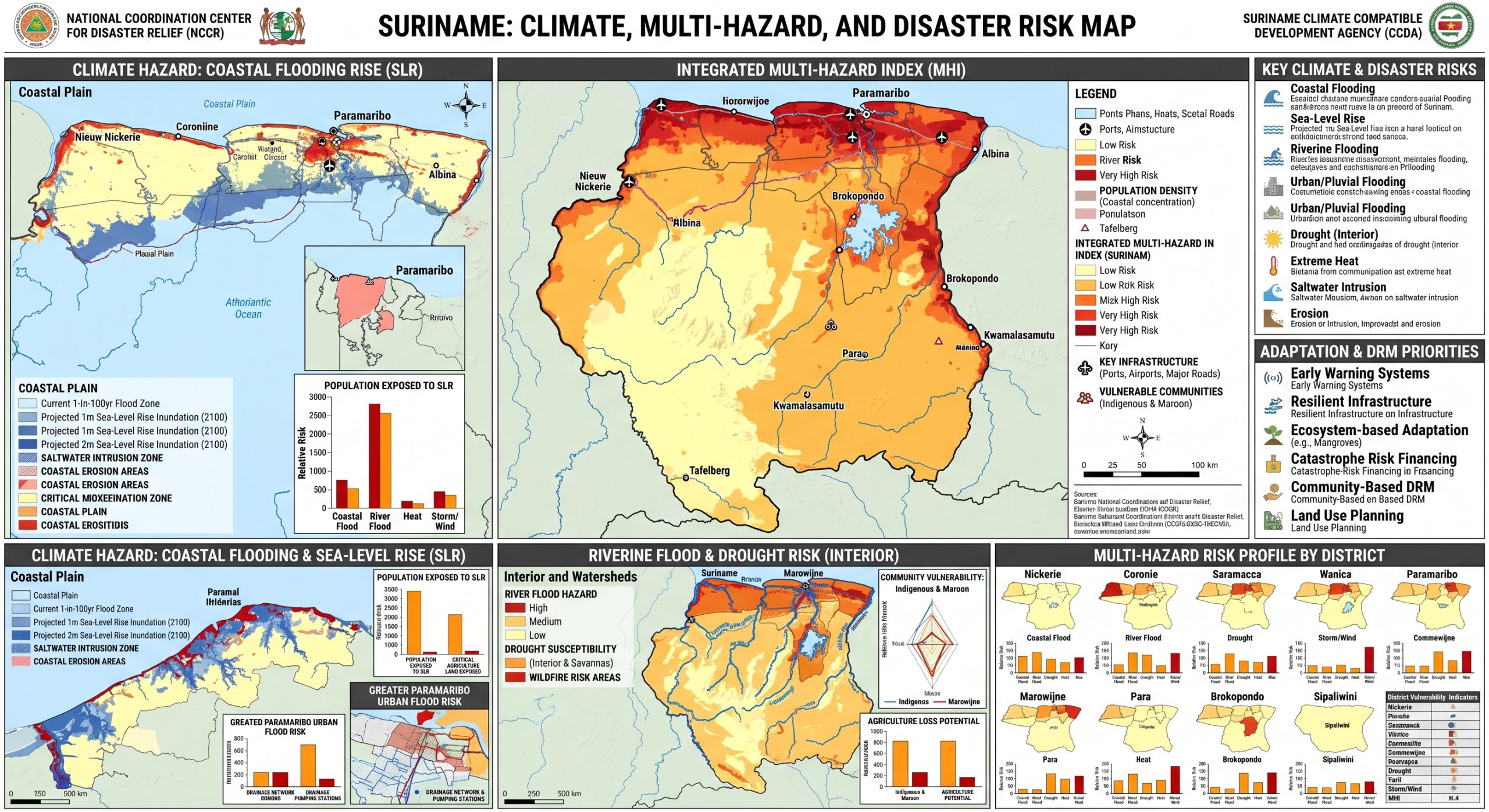
Suriname’s National Adaptation Plan warns that climate change impacts from temperature increase, rainfall increase and sea-level rise could affect over 40% of national GDP. The same climate-risk context makes coastal protection, water management, drainage, disaster-risk reduction, climate-resilient agriculture, forest conservation, health adaptation and resilient infrastructure central to national development planning. (UNFCCC)
Suriname’s climate-risk profile is defined by extreme coastal concentration, low-lying exposure, rising sea-level risk, recurrent urban and river flooding, emerging severe drought impacts in the interior, climate-sensitive agriculture, forest and mining pressures, and uneven local adaptive capacity. The country’s resilience pathway should combine coastal protection, Paramaribo drainage modernization, drought and river monitoring, climate-smart agriculture, forest conservation, resilient infrastructure, health adaptation, community-based early warning and forecast-based early action.

Key hazard profile
| Hazard | Main risk pathway | Highly exposed areas / systems |
|---|---|---|
| Coastal flooding and sea-level rise | Inundation, erosion, saltwater intrusion, damage to housing, roads, drainage, agriculture and public services | Paramaribo, Wanica, Nickerie, Commewijne, Saramacca, Coronie and the low-lying coastal plain |
| Urban/pluvial flooding | Drainage overload, road disruption, housing damage, water contamination, economic losses | Greater Paramaribo and other low-lying urban settlements |
| Riverine flooding | Village inundation, crop loss, transport disruption, health risks, displacement | Interior river communities, Suriname River, Marowijne, Tapanahony and upper river systems |
| Drought | Low river levels, water scarcity, crop failure, food insecurity, difficult river transport, school/clinic disruption | Interior villages, Sipaliwini, Upper Suriname, Tapanahony, Coeroeni and Indigenous/Maroon communities |
| Extreme heat | Heat illness, labour productivity loss, higher water demand, crop and livestock stress | Urban settlements, mining areas, agriculture zones, interior communities |
| Saltwater intrusion | Contamination of freshwater, soil salinization, damage to agriculture and drinking-water systems | Low-lying coastal agricultural zones and aquifers |
| Wildfire / forest fire | Air pollution, forest degradation, biodiversity loss, food and livelihood impacts | Drought-affected forest, savanna and interior areas |
| Storms and strong winds | Damage to roofs, crops, trees, power lines and local infrastructure | Coastal settlements, rural communities, exposed infrastructure corridors |
Climate trends and exposure
Suriname has a humid tropical climate, but climate variability is increasing. The most important climate-risk dynamics are rising temperature, heavier rainfall episodes, prolonged dry spells, sea-level rise, and changing seasonal hydrology. The World Bank Climate Change Knowledge Portal provides country-level climate data and projections for Suriname, including climate indicators for temperature, precipitation, sea-level change, extreme precipitation and heat risks. (Climate Change Knowledge Portal)
Sea-level rise is one of the most serious long-term risks. IDB’s State of the Climate Report summary estimates that a 1-metre sea-level rise could affect more than 6.4% of GDP, 7% of the population, and 5.6% of agricultural land. This is particularly serious because most people, major services, transport infrastructure, government institutions, agriculture and economic activity are concentrated along the coastal strip. (IADB Publications)
Sector-specific vulnerabilities
1. Coastal zone, Paramaribo and urban infrastructure
Suriname’s greatest physical exposure is in the low-lying coastal zone, especially Greater Paramaribo. The city and surrounding districts face a combination of sea-level rise, tidal influence, extreme rainfall, poor drainage, land subsidence in some areas, canal blockage, and aging water-management infrastructure. GFDRR notes that the 384-km coastal plain contains most of the country’s fertile land and economic activity, making sea-level rise a major development challenge. (GFDRR)
Urban flooding in Paramaribo is driven by intense rainfall, limited drainage capacity, inadequate maintenance of canals and sluices, settlement expansion into flood-prone areas, and backwater effects during high tides. Adaptation Fund project documentation for Paramaribo specifically frames the city’s risk around climate change-related floods and sea-level rise, requiring strategic urban planning and sustainable infrastructure investment. (Adaptation Fund)
Priority needs include drainage master planning, canal rehabilitation, tidal gates and sluice management, flood-retention areas, solid-waste control in drainage channels, climate-resilient roads, risk-sensitive land-use planning, and community-level flood preparedness.
2. Water security, drought and river transport
Suriname is also increasingly exposed to drought, particularly in the interior. Drought affects drinking water, sanitation, agriculture, food security, river navigation, access to schools and health services, and the ability of interior communities to move people and supplies by canoe. A 2025 report documented severe drought impacts in northern and interior Suriname, especially in Upper Suriname and Indigenous and Maroon communities, where rivers and creeks dried, crops failed, transport was disrupted, and access to clean water deteriorated. (The Guardian)
The same reporting noted that prolonged drought affected 52 villages and around 40,000 people across Sipaliwini, Upper Suriname, Tapanahony and Coeroeni, with major humanitarian implications for water, health, food security, education and transport. (The Guardian)
This shows that Suriname’s climate-risk profile is not only coastal. Interior communities are highly sensitive to drought because they depend on rivers for transport, water access, fishing, farming, school attendance, health outreach and supply chains.
3. Agriculture, livestock and food security
Agriculture is highly exposed to sea-level rise, saltwater intrusion, drought, excessive rainfall, floods, pests and heat stress. Coastal agriculture is especially vulnerable because much of the productive land is located only 1–3 metres above mean sea level, making it susceptible to sea-level rise, flooding and salt intrusion. Adaptation Fund documentation notes that saltwater intrusion threatens low-lying coastal agricultural fields, with negative implications for cash crops, food security and farmer livelihoods. (Adaptation Fund)
Main agricultural vulnerability pathways include:
saltwater intrusion into soils and irrigation/drainage systems;
crop losses from prolonged flooding and waterlogging;
drought-related crop failure in interior and rural communities;
heat stress affecting crops, livestock and farm labour;
increased pest and disease pressure under changing rainfall and temperature;
reduced freshwater availability for irrigation and livestock;
disruption of rural roads, canals and market access after floods.
Suriname’s NAP progress report identifies agriculture, along with water, energy and forestry, as a near-term priority sector for adaptation. (NAP Global Network)
4. Forests, biodiversity and ecosystem services
Suriname has one of the world’s highest forest-cover rates and is globally significant for tropical forest conservation. Forests provide carbon storage, biodiversity, water regulation, cultural value, food systems and disaster-risk reduction services. However, forests and ecosystems are increasingly exposed to drought, wildfire, illegal mining, land-use change, erosion, water pollution and biodiversity loss.
Gold mining is a major pressure point. Climate-displacement research notes that gold mining is a major export sector but also a driver of deforestation and vegetation-health decline, while flooding and sea-level rise can affect mining operations and infrastructure. (Othering & Belonging Institute)
Forest conservation is therefore not only a mitigation issue; it is also an adaptation strategy. Healthy forests regulate local hydrology, reduce erosion, protect watersheds, support interior livelihoods and buffer drought/flood extremes.
5. Energy and hydropower vulnerability
Suriname’s energy sector is climate-sensitive because hydropower depends on rainfall, river flows and reservoir conditions. Drought can reduce hydropower reliability, while extreme rainfall and flooding can affect dams, power infrastructure, access roads and transmission systems. The NAP progress report identifies energy as one of Suriname’s near-term adaptation priority sectors. (NAP Global Network)
Energy-sector adaptation should include hydrological forecasting, reservoir monitoring, power-system diversification, climate-resilient transmission and distribution infrastructure, emergency power planning for health and water services, and better integration between climate services and energy planning.
6. Public health and WASH vulnerability
Climate change affects health in Suriname through flooding, contaminated water, drought-related water scarcity, heat stress, smoke from fires, vector-borne disease risks, diarrhoeal disease, food insecurity and disruption of clinics. Floods can contaminate wells, pit latrines, surface water and drainage systems, while drought can force communities to rely on unsafe water sources.
During the prolonged drought affecting interior communities, reports highlighted waterborne illness, lack of clean water, disrupted clinics, shortages of medical supplies, sanitation problems and school closures. Children, elderly people, pregnant women, Indigenous communities, Maroon communities and remote households are especially vulnerable. (The Guardian)
Health adaptation should therefore be directly linked to early warning for flood, drought, heat, smoke, water quality and disease surveillance.
7. Mining, oil, fiscal exposure and transition risk
Suriname’s economy is highly dependent on natural-resource sectors, especially mining and extractives. The World Bank notes that mining contributes nearly half of public-sector revenue and more than 80% of exports, making the country vulnerable to external shocks. (World Bank)
Climate risk can affect mining through flooded access roads, damaged infrastructure, water-quality impacts, erosion, tailings risks and river transport disruption. At the same time, the expansion of oil and extractive activities creates transition-risk and environmental-governance challenges. Suriname’s resilience pathway must therefore combine climate adaptation with sustainable resource governance, forest protection, fiscal-risk planning and economic diversification.
Exposure, sensitivity and adaptive capacity
Exposure
Suriname is exposed to both slow-onset risks and rapid-onset hazards. Slow-onset risks include sea-level rise, saltwater intrusion, coastal erosion, temperature increase, drought, ecosystem degradation and water stress. Rapid-onset hazards include urban floods, river floods, extreme rainfall, storms, strong winds and wildfire.
Sensitivity
Sensitivity is high because people, infrastructure, fertile land and economic activity are concentrated in low-lying coastal areas, while interior communities depend strongly on rivers, forests, subsistence farming and climate-sensitive transport systems. Coastal households are highly exposed to floods and sea-level rise, while interior Indigenous and Maroon communities are highly exposed to drought, river-level decline, water contamination and access disruption.
Adaptive capacity
Suriname has important policy foundations, including its National Adaptation Plan 2019–2029. The NAP progress report states that the NAP prioritizes water, energy, forestry and agriculture for near-term adaptation; mining, tourism, infrastructure and housing for medium-term adaptation; and cross-cutting sectors including education, health, environment, disaster risk reduction and spatial planning. The NAP includes 133 adaptation measures, of which 57 are strategic-level measures and 76 are sector-level measures. (NAP Global Network)
However, implementation challenges remain: limited technical capacity, financing gaps, weak local-level climate-risk data, drainage and infrastructure deficits, insufficient interior drought monitoring, limited last-mile early warning, and the need to better integrate adaptation into spatial planning, public investment and sector budgets.
Priority adaptation and early warning needs
Suriname’s resilience strategy should focus on an end-to-end, impact-based, multi-hazard early warning system linked to coastal protection, urban drainage, river-basin management, drought response, health, agriculture, forests and social protection.
Key priorities include:
Coastal flood and sea-level rise monitoring
Develop high-resolution coastal elevation models, tide gauges, storm-surge monitoring, coastal erosion mapping and saltwater-intrusion surveillance.Urban flood impact-based forecasting for Paramaribo
Combine rainfall forecasts, tidal conditions, drainage capacity, canal levels, road exposure, critical facilities and vulnerable settlements into actionable flood alerts.Interior river and drought early warning
Monitor rainfall deficits, river levels, water points, groundwater, vegetation stress, food security, school/clinic access and canoe-navigation constraints.Drainage and water-management infrastructure
Rehabilitate canals, sluices, pumping systems, retention areas and tidal gates; strengthen maintenance and solid-waste control in drainage networks.Climate-resilient agriculture
Promote salt-tolerant crops, improved drainage, freshwater storage, water-efficient irrigation, crop diversification, agroforestry, drought advisories and farmer climate services.Forest and watershed protection
Protect forests, wetlands and mangroves; reduce mining-related degradation; restore riparian zones; and integrate ecosystem-based adaptation into flood and drought management.Health-climate surveillance
Link early warning to monitoring of heat illness, waterborne disease, diarrhoeal disease, vector risks, smoke exposure and malnutrition in flood- and drought-affected areas.Community-based early warning
Strengthen last-mile alerts through radio, mobile messaging, community focal points, river-level markers, evacuation routes, shelters and locally understood warning thresholds.Climate-resilient infrastructure and housing
Upgrade roads, bridges, schools, clinics, water systems and housing in flood-prone coastal and riverine areas using future climate-risk standards.Geospatial Decision Support System
Build a national DSS integrating coastal elevation, flood maps, rainfall forecasts, river levels, drainage assets, vulnerable settlements, Indigenous and Maroon communities, health facilities, schools, agricultural zones, forests, mining areas and early-action triggers.
Nationaal Coördinatie Centrum voor Rampenbeheersing – NCCR National Coordinator Center for Disaster Relief (NCCR) http://www.nccr.sr.org

Ministry of Defense, Kwattaweg #29, Paramaribo, Suriname Phone: (597) 52 0840/42 641

UNDRR
Suriname has launched the process of establishing its National Strategy for Disaster Risk Reduction (Country Work Programme), aligning it closely with the nation’s climate change adaptation plans and actions.
Located on the northeastern coast of South America, Suriname is bolstering its disaster risk reduction (DRR) efforts through a comprehensive DRR Gap Analysis Workshop. Supported by organizations such as the Caribbean Disaster Emergency Management Agency (CDEMA), the Disaster Risk Reduction Centre at the University of the West Indies, USAID’s Bureau for Humanitarian Assistance (BHA) via the PROSE programme, and the United Nations Office for Disaster Risk Reduction (UNDRR), the workshop aimed to evaluate the current state of DRR efforts in Suriname. It focused on identifying key gaps and challenges and ensuring alignment with the existing National Adaptation Plan.
The workshop represents a crucial step towards developing a comprehensive Country Work Programme (National Strategy for Disaster Risk Reduction) that will be in line with the current National Adaptation Plan, the Paris Agreement, the Regional Comprehensive Disaster Management (CDM) Strategy, and the Sendai Framework for Disaster Risk Reduction. Suriname acknowledges the need to bolster its resilience against the impacts of climate change and natural hazards such as flooding, heavy rainfall, and coastal erosion.
To ensure coordination and alignment between ministries responsible for implementing climate change adaptation and disaster risk reduction agendas, the workshop was inaugurated by the Minister of Spatial Planning and Environment, H.E. Mr. Marciano Dasai. Minister Dasai emphasized the importance of addressing climate change as an integral part of disaster risk management and highlighted the significance of the workshop in fostering a comprehensive approach to climate change adaptation and disaster risk reduction to safeguard the country’s development goals. Colonel Jerry Slijngard, Coordinator of the National Coordination Centre for Disaster Risk Management (NCCR), reiterated the Center’s commitment to ensuring the safety and well-being of the population and underscored the workshop’s importance in identifying areas for improvement and developing strategies to enhance disaster risk reduction efforts in Suriname.
The workshop focused on integrating climate change adaptation (CCA) into Disaster Risk Reduction (DRR), aligning with Suriname’s National Adaptation Plan (NAP) 2020 and the Multi-annual Development Plan 2022-2026. Key stakeholders from government agencies, non-governmental organizations, the private sector, academia, and community representatives came together to:
- Assess the current state of DRR efforts in Suriname.
- Identify gaps in policies, plans, and programs addressing disaster risk reduction and climate change adaptation.
- Gather input from diverse stakeholders to understand perspectives and experiences on climate change adaptation and disaster risk reduction.
- Develop recommendations and action plans to address identified gaps and enhance DRR initiatives, including aligning with climate change adaptation strategies.
- Foster partnerships and collaborative approaches to enhance disaster resilience in Suriname by integrating climate change adaptation into disaster risk reduction efforts.
One of the primary discussions revolved around the country’s urgent need to develop specific legislation related to disaster risk management, aligned with ongoing efforts on climate change adaptation, to clarify mandates, roles, and responsibilities while ensuring the technical and human capacities for implementing mitigation, adaptation, and preparedness actions sustainably. Participants discussed:
- Developing a National Disaster Risk Management Policy incorporating climate change adaptation
- Strengthening existing laws and regulations related to disaster risk management
- Establishing clear roles and responsibilities for disaster risk reduction and climate change adaptation at all government levels
- Developing guidelines for disaster risk assessment, early warning systems, emergency response planning, and recovery planning
The DRR Gap Analysis Workshop in Suriname represents a crucial step towards achieving the 2030 Sustainable Development Agenda and fulfilling national commitments to the Paris Agreement. By fostering collaboration and knowledge exchange among a diverse range of stakeholders, the workshop aimed to initiate the process of developing a Country Work Program (CWP) for Suriname. This initiative seeks to enhance the country’s disaster risk management capabilities and integrate climate change adaptation (CCA) into disaster risk reduction (DRR) efforts.
Moving forward, the next phase in the preparation of the CWP involves the development of the CDM Audit tool. This tool is designed to evaluate Suriname’s capacities across all stages of the disaster management cycle. The consortium comprising CDEMA, UWI-DRRC, USAID-BHA-PROSE, and UNDRR will continue their collaborative efforts throughout the various stages of CWP preparation. Their goal is to ensure alignment with the climate adaptation agenda while incorporating concrete actions for disaster risk reduction financing, human mobility, recovery, enhancement of disaster risk knowledge, and the establishment of multi-hazard early warning systems, among other key objectives.
Background information on Suriname
Suriname’s risk profile is predominantly characterized by floods. In 2006, the country experienced severe flooding that directly impacted approximately 25,000 individuals across 150 villages, with estimated costs reaching USD 40 million. More recently, the April 2021 floods affected all ten districts of the country, with final costs still pending determination. While floods remain the most prevalent hazard, especially in terms of exposure, other risks, particularly biological hazards, also contribute significantly to the national risk profile.
The public health challenges posed by biological hazards are compounded by the socioeconomic impacts of events such as the recent virus outbreak, exacerbating existing inequalities and revealing underlying vulnerabilities that heighten disaster risk. The intricate dynamics of climate change further compound these challenges, impacting not only the hydrometeorological risk landscape but also generating and amplifying environmental and biological hazards with far-reaching consequences across various sectors. Effective risk management necessitates a systemic approach that comprehensively explores the interconnected nature of economic, political, human, and environmental systems.
Suriname’s development framework, as outlined in the National Development Plan 2017-2021, underscores the country’s commitment to disaster risk management and climate change action. While the Plan acknowledges well-established climate-related risks, it also recognizes anthropogenic hazards, reflecting an understanding of the multi-hazard environment. Serving as a key tool for the country’s development, the National Development Plan lays the groundwork for directly addressing disaster risk and the social determinants underlying it. The Plan commits to formulating a disaster risk reduction strategy for Suriname, encompassing crucial areas such as risk identification, preparedness, national coordination for response, post-disaster recovery and reconstruction with a focus on resilience-building, and partnerships for technical and financial support. Consequently, the National Development Plan provides a solid foundation for the Country Work Programme, serving as a pivotal entry point for the program’s implementation.
In addition to the National Development Plan, Suriname’s National Climate Change Policy Strategy and Action Plan (2013), National Adaptation Plan (2020), and Updated Nationally Determined Contribution (2020) underscore the country’s dedication to climate change mitigation and adaptation efforts. Supported by the National Coordination Centre for Disaster Relief (NCCR) as the designated competent authority, Suriname’s disaster risk management framework operates within a multi-stakeholder environment that engages various sectors, state agencies, non-governmental organizations, local government entities, and the community.
Despite progress made thus far, there are several critical areas that require urgent attention to bolster the national disaster risk management framework. Suriname’s current approach to disaster risk management primarily focuses on response activities, lacking adequate mechanisms for risk mitigation and preparedness. The absence of approved and operationalized disaster legislation within the national framework poses a significant challenge. Furthermore, deficiencies in the legislative environment for integrating disaster risk reduction into development processes have impeded progress in this area. Weaknesses in legislative and policy frameworks have manifested as operational and institutional hurdles, leading to unclear delineation of responsibilities, fragmented initiatives, insufficient ownership, and limited mainstreaming of disaster risk reduction efforts. Moreover, inadequate human, material, and financial resources allocated to disaster risk management activities have hindered progress. Rising debt levels have not only impeded economic growth and development in Suriname but have also constrained the allocation of resources for productive investments and new initiatives.
Suriname faces challenges in effectively collecting, analyzing, and utilizing data to track progress in reducing climate and disaster risks. This lack of data hampers the country’s ability to make informed decisions related to development and economic growth. Essential baseline data, sector-specific risk profiles crucial for policymakers in formulating integrated policies, plans, strategies, and actions (with the exception of an agriculture sector risk profile), and comprehensive national-level hazard and disaster risk assessments are currently unavailable, posing obstacles to mainstreaming efforts.
Policy coherence is another key area requiring enhancement. While Suriname has established the National Development Plan and specific plans and policies addressing climate change, a dedicated disaster risk management policy or plan is lacking. Although existing policy instruments demonstrate progress toward strategic, conceptual, and operational coherence, institutional, financial, and monitoring and evaluation aspects exhibit deficiencies. In a resource-constrained setting, financial and monitoring and evaluation coherence are particularly critical. Institutional coherence is hindered by fragmented ownership across state entities. While the NCCR oversees disaster risk management, the responsibility for developing and coordinating the implementation of climate-related policies and plans falls under the Directorate for the Environment within the Ministry of Spatial Planning and Environment. The implementation of the National Development Plan is overseen by the country’s Planning Bureau. Therefore, establishing joint mechanisms to support policy coherence is imperative.
For more detailed information on Suriname’s disaster risk reduction initiatives, please refer to the Situational Analysis report prepared by UNDRR, CDEMA, and NCCR in 2022.
Surinum Disaster Risk Management :


Suriname a small country on the northern coast of South America, Suriname initiated a National Disaster Preparedness Baseline Assessment through its National Coordination Center for Disaster Relief (NCCR) in partnership with the University of Hawai’i’s Pacific Disaster Center (PDC). Using a collaborative, stakeholder-led process, the assessment will help evaluate multidimensional risk and vulnerability within each of Suriname’s ten districts.
To kick off the project, a workshop and exchange took place on June 13, 2023 at the Courtyard by Marriott Paramaribo. The event brought together representatives from more than 25 different ministries, nonprofits, and international organizations—all of whom have critical insights and experience in solving complex disaster management problems and responding to major events.
“Thoughts will be exchanged with all these actors about proper disaster preparedness,” said NCCR coordinator Col. Jerry Slijngard during his opening remarks. According to Slijngard, the kick-off is the first step towards coordinated functioning in the event of disasters. He said the PDC will play an important role in this by developing a “disaster aware tool” from which all partners can obtain their information.
“This system will help the institutions to respond more quickly.”
NCCR coordinator Col. Jerry Slijngard
The National Disaster Preparedness Baseline Assessment is an internationally recognized program developed by PDC that will use a scientific process to help improve the availability and reliability of risk data and early warning information in order to safeguard Suriname now and into the future.
“The baseline assessment is the only operationalized approach to the UN Sendai Framework for Disaster Risk Reduction and is also designed to help countries achieve the targets for sustainable development and the targets of the Paris Agreement—ensuring nobody is left behind.”
—PDC’s Director of Global Operations Dr. Erin Hughey
Although Suriname is one of only three carbon-negative nations in the world, it has been significantly affected by the worsening climate crisis—especially in coastal and inland areas where people are vulnerable to extreme flooding and other severe hazards.
According to Dr. Hughey, no country is immune to the impacts of climate change and it will require collaboration across national borders and a global network of partners to help build resilience and mitigate challenges.
“To understand and protect against risk, PDC will collaborate with NCCR to conduct the assessment and to share and exchange knowledge among all stakeholders. Together, we will develop a five-year action plan to enhance capacities and prioritize strategies and investments to build more disaster-resilient and climate-change-resilient communities,” said Dr. Hughey.
The assessment is set to take place over a period of twelve months and provide a comprehensive analysis of national and subnational disaster management capacities. It will include assessment reports for each of the ten districts assessed. All data and information produced will be processed and visualized geospatially and made available to Suriname as well as through PDC’s DisasterAWARE platform.
DisasterAWARE provides real-time early warning for multiple hazards and advanced modeling of potential hazard impacts as hazards occur. The system is designed for the disaster management and humanitarian response community who will leverage Suriname’s assessment information to support effective disaster planning, preparedness, response, and mitigation.