The Gambia Climate, Multi-Hazard Risk, Vulnerability and Disaster Profile
National overview and early-warning planning priorities | November 2026
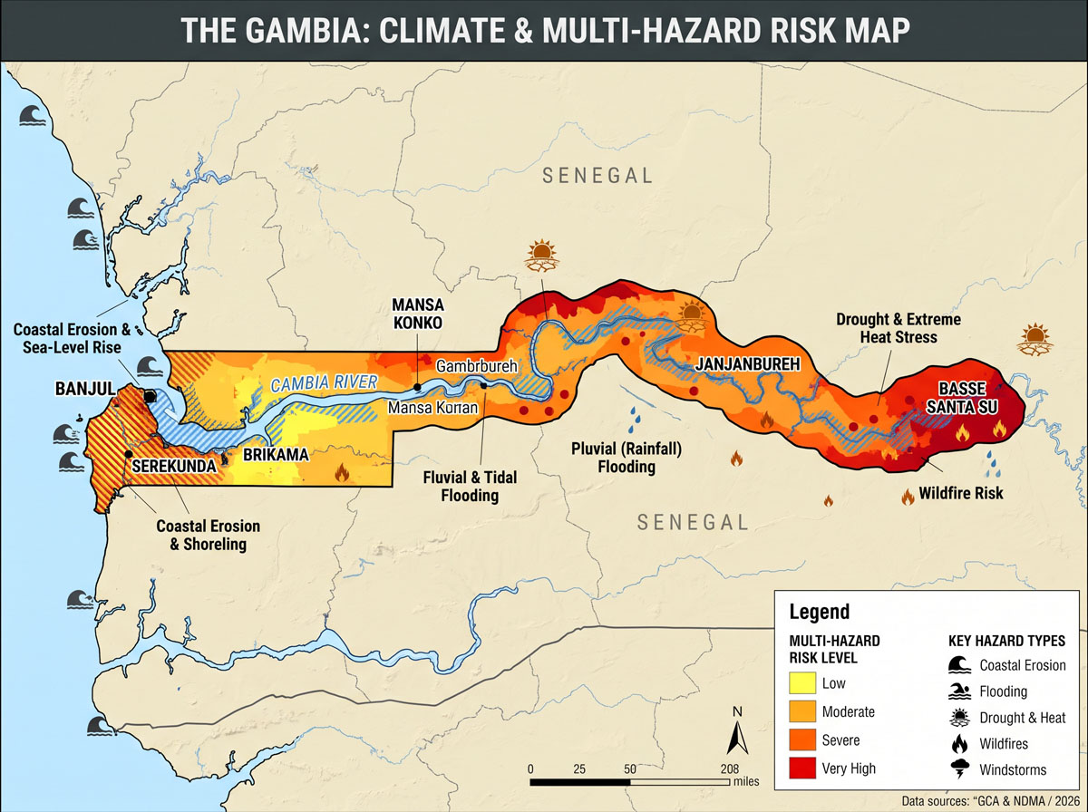
The Gambia’s most immediate disaster risks are heavy-rain flooding in Greater Banjul and other settlements, rain-season windstorms, and drought and heat stress in farming areas. Along the Atlantic coast and lower River Gambia, sea-level rise, coastal erosion and saltwater intrusion are increasing risks to settlements, infrastructure and livelihoods. The preliminary 2024 census counted 2.42 million people. A single flood can disrupt housing, roads, markets, schools and water supply where these services share the same low-lying corridors. gambia.unfpa.org
1. Climate baseline and projected change
| Climate factor | Risk implications |
|---|---|
| Rainy season and variability | The Department of Water Resources (DWR) identifies June to October as the rainy season, with May and November as transition months. The timing of the first effective rains and the length of dry spells matter for crop establishment. Short, intense downpours can cause damaging floods within the same season. meteogambia.gm |
| Warming and extreme heat | The national climate hazard assessment found that mean annual temperature rose by about 1°C from 1980 to 2023, with stronger temperature extremes in the north and east than on the coast. Under the high-emissions SSP3-7.0 scenario, the World Bank’s Climate Change Knowledge Portal projects median warming of 1.4°C in 2040–2059 relative to 1995–2014, with a 10th–90th percentile range of 0.9°C to 2.0°C. gca.org |
| Future rainfall | The same mid-century model ensemble spans both wetter and drier outcomes for annual rainfall. Water and agriculture planning should account for delayed onset and damaging dry spells, while drainage and flood planning should assess short-duration rainfall extremes separately. Climate Change Knowledge Portal |
| Sea-level rise | The national coastal flood assessment uses 22 cm under SSP2-4.5 and 25 cm under SSP5-8.5 by 2050 as sea-level-rise inputs. Higher baseline water levels can increase coastal flood depths and make gravity drainage less effective when heavy rain coincides with high tide. gca.org |
The 2026 rainy season illustrates why within-season monitoring matters. FAO reported that rainfall deficits from mid-June to mid-July delayed planting and prompted replanting in parts of southeastern Central River Region. Improved rainfall from late July supported crop recovery. Separately, the Cadre Harmonisé estimated 262,000 people in Crisis or worse acute food insecurity during the June–August 2026 lean season. fao.org
2. Multi-hazard geography and exposure
| Area | Main hazards and exposed assets |
|---|---|
| Banjul City, Oyster Creek and the lower estuary | Heavy rainfall, high tides and coastal overtopping can compound flooding. Housing, commercial areas, port operations and the roads serving them are exposed. Access-road flooding can interrupt operations even where the facility itself remains usable. PreventionWeb |
| Kanifing and the Greater Banjul urban fringe | Pluvial flooding, caused by rainfall pooling or flowing over land, is a priority along the Kotu Stream and in eastern urban areas including Ebo Town. Inadequate drainage, obstructed channels and development in low-lying areas increase exposure to damage and service interruption. The Kotu catchment extends from Nema Kunku to the Atlantic coast. PreventionWeb |
| Atlantic tourism and fisheries coast | Beach erosion and wave overtopping affect the Fajara–Senegambia corridor, threatening shoreline assets and livelihoods tied to beach access. Marine wind and wave warnings also matter for artisanal fishing and landing operations. PreventionWeb |
| River Gambia floodplain and tidal rice areas | River flooding and waterlogging can damage crops and isolate settlements. During low dry-season flows, saltwater can penetrate farther upstream, affecting freshwater availability and water suitability for rice irrigation. River stage and salinity therefore need to be monitored together in tidal agricultural areas. UNDRR |
| North Bank, Central River and Upper River farming areas | Dry spells, extreme heat, bushfires and severe rain-season winds threaten rainfed crops, livestock, housing and stored seed. Local flash floods also affect inland settlements. IOM identified Niani, Niamina East, Niamina West and Sabach Sanjal among the concentrations of livelihood distress in its 2025–2026 assessment. dtm.iom.int |
Greater Banjul’s flood risk is changing over time. A World Bank assessment attributed roughly 90% of modeled flood damage in its 2020 baseline to rainfall-driven flooding. Coastal flooding rises to about 40% of modeled flood damage by 2070. The same assessment estimates that average annual damage increases from US$21.6 million in 2020 to US$28.6 million by 2040. These figures support near-term investment in drainage and flood storage alongside longer-term coastal protection and land-use planning. PreventionWeb
3. Vulnerability and cascading impacts
- Housing, water and health. Flooding can collapse weak buildings, contaminate shallow wells and overwhelm pit latrines. Flooded roads also restrict access to clinics, schools and markets. Households with limited savings, people who need evacuation assistance and families dependent on daily income face greater disruption and recovery costs. gambia.un.org
- Agriculture, livestock and food security. Late onset and dry spells can force farmers to replant or reduce yields. Heat and water shortages add pressure on livestock and labour, while floods can destroy crops and stored seed in particular locations. In IOM’s assessment of 102 locations in North Bank and Central River, 94% reported drought, 79% flooding and 84% a reduction in available drinking water. These are findings from the assessed locations. Focus groups identified women as particularly affected through food access, care responsibilities and slower recovery. dtm.iom.int
- Transport, tourism and the economy. Flooding of access roads can disrupt the Port of Banjul, airport connections and feeder routes serving farms and markets. Shoreline retreat threatens tourism assets, while heat stress reduces outdoor labour productivity. The 2026 Country Climate and Development Report models 2050 GDP 9.3% below a no-climate-shock baseline under a dry, hot scenario with business-as-usual development and existing adaptation. With expanded adaptation, the modeled gap falls to about 2.6%. documents1.worldbank.org
4. Selected disasters and documented impacts
| Event | Documented impact |
|---|---|
| 2011–2012 drought | Severe rainfall deficits caused major crop failures, particularly in northern and central farming areas. The World Bank reports historical estimates of 428,000 to 700,000 people affected, with severe food insecurity across 19 districts. documents1.worldbank.org |
| July 2021 windstorms | The IFRC final report recorded 11 deaths. It cited a joint assessment that counted 36,159 people affected, including 1,531 displaced. Storms damaged homes, schools, health centres and community seed stores. 1 |
| July–August 2022 flash floods | The UN assessment reported 276 mm of rain at Yundum airport during the late-July event. NDMA identified at least 50,738 people directly affected. The IMF climate policy diagnostic cites a preliminary estimate of about US$82 million in direct damage. gambia.un.org |
| August–September 2025 flash floods | The IFRC situation report cited NDMA figures of 10,560 people in 1,321 affected households. Heavy rains damaged homes, roads, markets and culverts, with notable impacts in Upper River, Central River, Lower River, West Coast and Kanifing. The Gambia 2025 Flash Flood |
5. Disaster governance and early-warning capacity
| Institution or programme | Verified role or milestone |
|---|---|
| National Disaster Management Agency (NDMA) | Coordinates disaster preparedness, response and recovery under the National Disaster Management Act of 2008. Its planning framework includes the National Disaster Risk Management Policy 2024–2033 and the National Disaster Risk Mitigation Plan 2025–2033, which NDMA reported as validated in 2025. UNEP Law and Environment Assistance Platform |
| Department of Water Resources (DWR) | Provides meteorological, hydrological, agricultural and marine services, including seasonal rainfall forecasts and 10-day food-security bulletins. The WMO register lists DWR as a meteorological alerting authority and publishes its Common Alerting Protocol (CAP) feed. MoFWR |
| Early Warnings for All (EW4All) | The national roadmap was endorsed in October 2025, with a 2027 coverage goal. Priorities include a national disaster risk information system, expanded monitoring, impact-based forecasting, accessible warning dissemination and stronger emergency operations centres. DWR, NDMA, the communications ministry and The Gambia Red Cross Society participate in national coordination. CREWS |
| Kotu Stream flood warning and mitigation | The World Bank’s September 2026 project update confirmed installation of automatic rain gauges and water-level recorders. Work was continuing on forecasting, warning dissemination and operating procedures. The update also reported that procurement for flood-protection works was underway. documents1.worldbank.org |
| Climate adaptation and disaster finance | NDC 3.0, submitted in August 2026, sets out adaptation and loss-and-damage priorities and links implementation to the ongoing National Adaptation Plan process. In September 2026, the Ministry of Finance and Economic Affairs and partners held a validation workshop on the draft National Disaster Risk Financing Strategy ahead of government consideration. UNFCCC |
Existing flood anticipatory action
The Gambia Red Cross Society’s Simplified Early Action Protocol for pluvial floods, published in May 2026, specifies a DWR 72-hour forecast indicating a 70–80% probability of rainfall exceeding 100 mm in 24 hours for targeted flood-prone locations. It links activation to actions such as community alerts, drainage clearance, water and sanitation support, and cash assistance to eligible households. The protocol provides a starting point for testing how forecast rainfall translates into impacts across catchments with different drainage conditions. Pluvial Floods – Anticipation Hub
6. Priorities for impact-based forecasting and early action
| Priority | Forecast and exposure information | Early action to test |
|---|---|---|
| Kotu Stream and eastern Greater Banjul flooding | Combine short-duration rainfall forecasts, gauge observations, tide at the outlet, drainage conditions and a map of frequently flooded buildings and roads. | Clear priority drains before storms, pre-position pumps where appropriate, alert exposed clinics and schools, and arrange assisted evacuation where access is likely to fail. |
| Banjul coastal and estuarine flooding | Combine tide, surge and wave forecasts with low-point elevations, flood-defence condition and the elevation of critical access routes. | Protect critical equipment, coordinate port and road access, and issue location-specific warnings for communities and landing sites. |
| River flooding and rice-area salinity | Track upstream rainfall, river levels, local tides and water salinity at irrigation intakes. Use River Gambia basin cooperation to improve upstream data exchange. | Warn settlements and farmers before access routes flood. Adjust intake or irrigation schedules when salinity exceeds locally agreed crop or water-use thresholds. mofea.gov.gm |
| Agricultural drought and heat | Combine seasonal and 10-day outlooks with rainfall onset, dry-spell duration, crop stage, soil moisture and water availability. | Time planting or replanting advice, mobilise seed and livestock support, and use heat forecasts to guide work schedules and health outreach. meteogambia.gm |
| Severe windstorms | Combine thunderstorm and gust forecasts with local records of weak roofs, treefall, and damage to schools and health facilities. | Issue short-lead alerts through CAP, local radio and community networks, and prepare safe shelter and access arrangements for exposed communities. meteogambia.gm |
A practical first phase would pair urban flood forecasting in the Kotu catchment with crop-stage drought and heat advisories in North Bank and Central River. The flood pilot can use installed gauges, mapped exposure and the existing Red Cross protocol. The agricultural pilot can build on DWR’s 10-day bulletins and measure whether advice reaches farmers in time to act. Both pilots should track warning receipt, usable lead time and action taken, disaggregated by location, sex, age and disability. Validate local thresholds against observed impacts before wider rollout. documents1.worldbank.org
Planning resources · Greater Banjul flood, erosion and damage GIS layers · DWR forecasts and alerts · UNDRR national flood and drought risk profile
National Disaster Management Agency https://ndma.gm/
The Gambia National Disaster Management Agency
As the incidence and severity of disasters are on the rise, disaster management deserves the highest priority. Until recently, disaster management was considered a post-disaster activity focusing mainly on rescue, relief, and rehabilitation with emphasis on state-centric approaches. In the face of challenges posed by the paradigm shift from rescue and relief operations to disaster prevention and preparedness, the NDMA policy makes a significant case for deliverable development objectives.
Disaster Management is an important issue that cannot be addressed by the government alone. It calls for a convergence of efforts from both agencies and institutions to undertake various types of tasks at various stages of the disaster management cycle.
National Policy
The Policy distills key recommendations from international conventions and protocols on disaster management and adapts them to the overall country programme. This, in practical terms, should be reflected in a coordinated and harmonized disaster management approach that links national, regional, and international strategies.
The Government of the Gambia views such an approach as an extremely important issue because any national policy that is at variance with international standards can have serious implications for the conduct and realization of disaster management goals and strategies. Today, a malfunction in the disaster management mechanism in some remote community in the Upper River Region, for example, could have far-reaching disastrous consequences elsewhere.
National Disaster Goals
- Articulate the vision and goals for disaster management in The Gambia.
- Outline the strategic direction to guide the development of disaster management Policies.
- Align the strategic direction for disaster risk reduction with international norms and framework conventions.
- Mainstream disaster mitigation into relevant areas of activity of the Government, NGOs, and Civil Society Organizations.
- Strengthen the governance and accountability arrangements in place that support the achievement of disaster management priorities.
National Vision
Safer and resilient communities in which the impact of hazards would not hamper development and the ecosystem, and the provision for a better quality of life through effective emergency and disaster services.
Strategic Objectives
- To integrate disaster risk reduction into sustainable development policies and planning.
- To develop and strengthen institutional mechanisms and capacities to build resilience to hazards.
- The systematic incorporation of international, regional, national, and local disaster risk reduction strategies and approaches into the implementation of emergency preparedness, response, and recovery.
- To achieve a comprehensive, all-hazard, all-agencies approach by achieving the right balance of prevention, preparedness, mitigation, response, and recovery.
- Prepare communities to ensure that they are fully equipped to anticipate and respond to disaster events.
- To promote a transparent, systematic, and consistent approach to disaster risk assessment and management.
- A multi-stakeholder participatory approach, including community participation at all levels.
- Develop a database and information exchange system at the national and international levels.
Download documents
https://drive.google.com/drive/folders/1tRPEa8LxOQZXGiPfk-xWHvSvA3-Dx8r0?usp=sharing
