Exceptional El Niño 2026-2027: A Call for Urgent Preparedness
The copyright © 2026 Z M Sajjadul Islam, Advisor, Multi-Hazard Early Warning System Design and Implementation Center (MHEWC – www.mhewc.org & www.glocs.org ). All rights reserved. Any material quoted, reproduced, adapted, or extracted from this proposal must be properly cited and attributed to the author. Please call at +8801711979179, Email: zmsajjad@gmail.com
Why does El Niño develop?
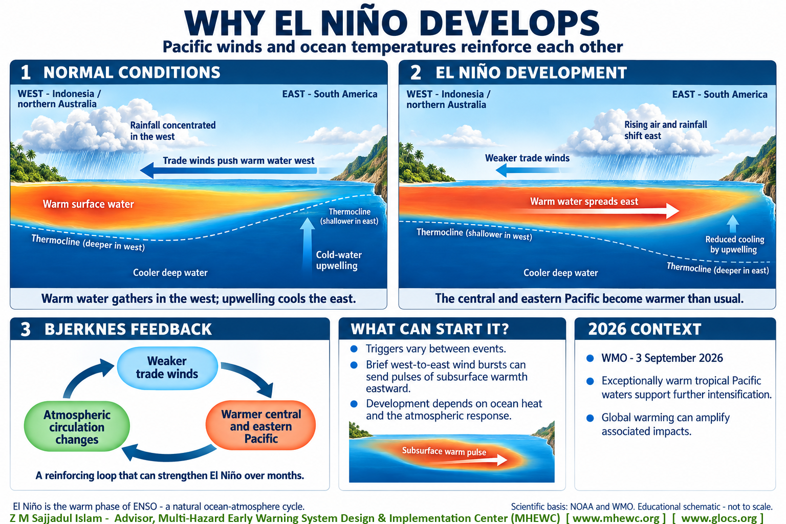
El Niño develops when changes in Pacific Ocean temperatures and winds reinforce each other, allowing unusually warm water to spread across the central and eastern equatorial Pacific. This interaction is part of a natural climate cycle called the El Niño-Southern Oscillation, or ENSO.
The process works like this:
- Normally, trade winds push warm water westward. These winds blow across the tropical Pacific from South America towards Indonesia and northern Australia. Warm surface water accumulates in the western Pacific, while colder water rises from below in the eastern Pacific. This upward movement, called upwelling, helps keep the eastern ocean relatively cool.
- When the trade winds weaken, the ocean’s heat distribution changes. Warm water can spread eastward, and upwelling becomes less effective at cooling the surface. The central and eastern Pacific consequently become warmer than usual.
- The warmer ocean then changes the atmosphere above it. Rising air, thunderstorms and rainfall shift towards the central and sometimes eastern Pacific. These changes weaken the usual atmospheric circulation and trade winds further, allowing additional warming. Scientists call this reinforcing process the Bjerknes feedback. It helps El Niño develop and strengthen over several months.
The initial trigger can vary between events. Natural fluctuations in tropical weather can produce brief episodes of winds blowing from west to east, called westerly wind bursts. These can generate ocean waves that carry a pulse of subsurface warmth eastward and help initiate or strengthen El Niño. Development also depends on the ocean’s existing heat distribution and whether the atmosphere responds strongly enough to sustain the feedback.
For the 2026 event you mentioned, WMO reports that exceptionally warm tropical Pacific conditions are supporting further intensification. El Niño’s natural ocean-atmosphere mechanism operates against a warming global climate, which can amplify associated heat and other weather impacts.
Why does La Niña develop?
La Niña develops when stronger Pacific trade winds and cooler ocean temperatures reinforce each other, producing unusually cool surface water across the central and eastern equatorial Pacific. It is the cool phase of the El Niño-Southern Oscillation (ENSO), a natural interaction between the ocean and atmosphere.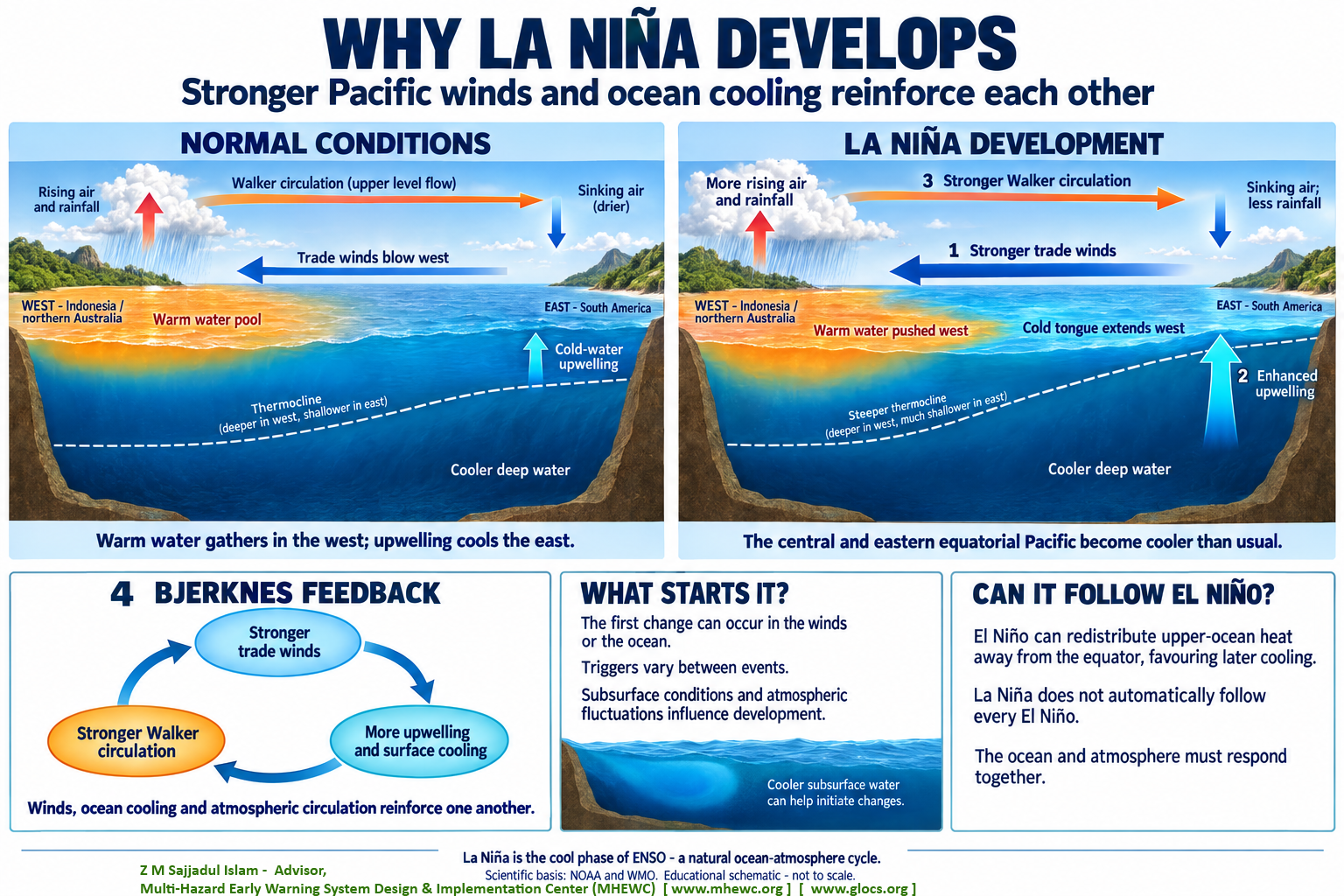
The process works through four connected changes:
- Trade winds become stronger than usual.
These winds blow from east to west, across the tropical Pacific from South America towards Indonesia and northern Australia. Stronger winds push more warm surface water towards the western Pacific. - Cold-water upwelling increases.
Colder water from below reaches the surface more effectively in the eastern equatorial Pacific. This strengthens the relatively cool band of surface water, often called the cold tongue, which extends farther west along the equator. The central and eastern Pacific consequently become cooler than usual. - The atmosphere responds to the stronger temperature contrast.
Over the warm western Pacific, rising air, thunderstorms and rainfall become more pronounced. Over the cooler central and eastern Pacific, sinking air suppresses cloud formation and rainfall. This strengthens the Walker circulation, the large atmospheric circulation connecting these regions. - The stronger circulation reinforces the winds and cooling.
The atmospheric response strengthens the trade winds further. These winds support additional upwelling and surface cooling, which reinforces the atmospheric response again. This is the Bjerknes feedback, operating in the direction that strengthens La Niña.
The initial trigger varies between events. Sometimes the ocean begins cooling before the winds strengthen; sometimes stronger winds help initiate the cooling. Natural atmospheric fluctuations and the ocean’s existing subsurface conditions influence whether these changes develop into a sustained event.
La Niña can also develop after an El Niño. During El Niño, ocean circulation can redistribute upper-ocean heat away from the equator, creating conditions that favour subsequent cooling. However, an El Niño is not automatically followed by La Niña; the ocean and atmosphere must evolve together to establish the cool phase.
Exceptional El Niño 2026-2027: A Call for Urgent Preparedness

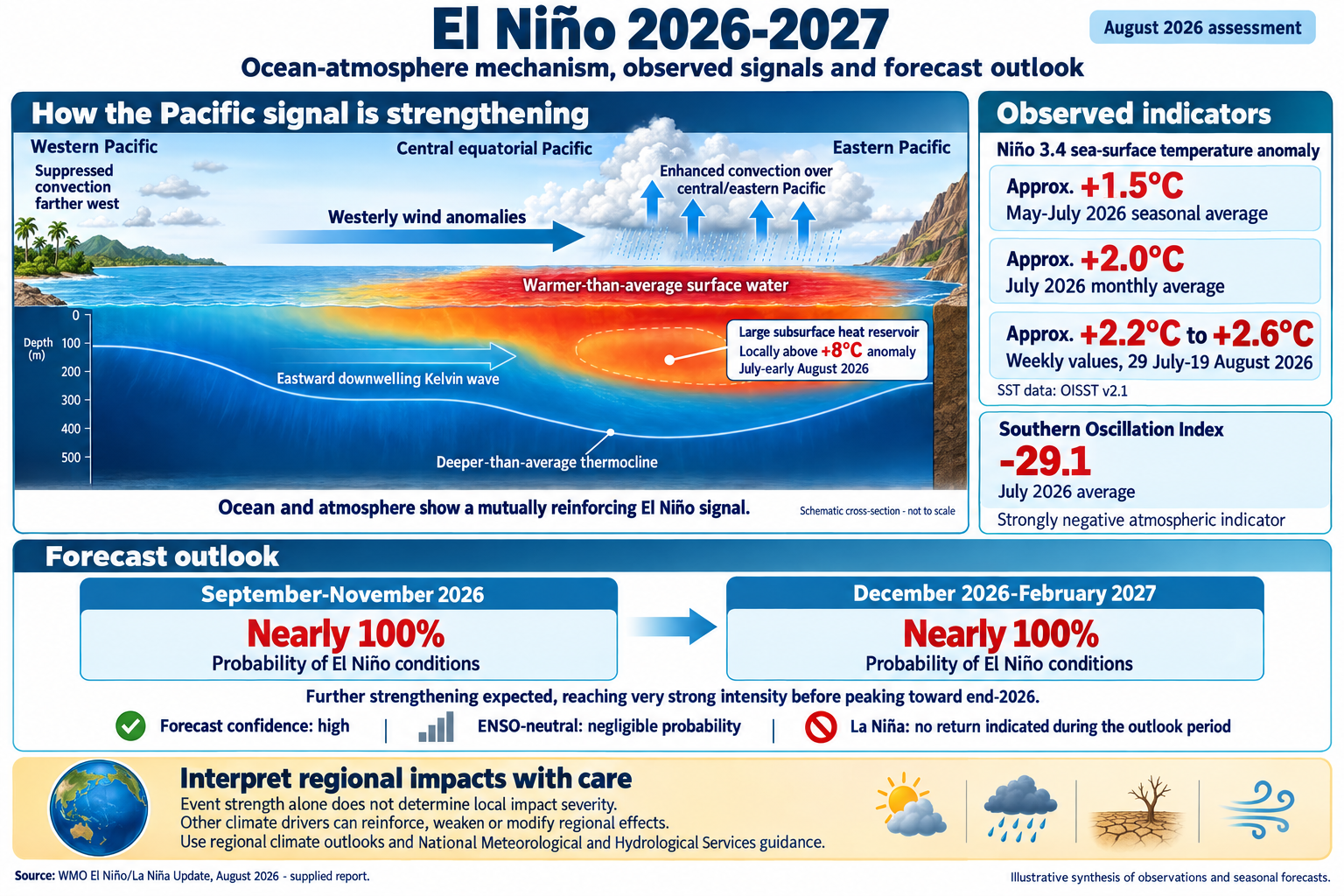
The latest WMO Update, issued on 3 September 2026, reports an exceptionally high likelihood, close to 100 percent, that El Niño will persist through the September-November 2026 and December 2026-February 2027 seasons. This is the first time a WMO El Niño/La Niña Update has expressed such a high degree of confidence.
El Niño is now firmly established in the tropical Pacific. Sea-surface temperatures in the central and eastern equatorial Pacific are well above average and continuing to rise. Subsurface ocean temperatures were more than 8°C above normal in some areas during July and early August, creating a large reservoir of warm water that may support further intensification.
WMO forecasts indicate that El Niño will strengthen further, reach very strong intensity and peak toward the end of 2026. If the current trajectory continues, the event could rank among the strongest observed in the modern monitoring era. However, the strength of an El Niño event does not automatically determine the severity of impacts in every location. Regional consequences depend on timing, geography, interactions with other climate drivers, exposure, vulnerability and preparedness.
The impacts may continue well into 2027, including through elevated global temperatures and major changes in rainfall patterns. The powerful 2023-2024 El Niño contributed to 2024 becoming the warmest year on record, alongside the continuing influence of human-induced climate change. WMO will continue monitoring global temperatures and related climate risks.
Why does this matter?
The term El Niño refers to the “Christ Child” or “boy child” in Spanish. Peruvian fishermen used the name because the warm ocean current often became noticeable around Christmas. The name may sound harmless, but the consequences of a strong El Niño can be serious.

El Niño can disrupt agriculture, food security, fisheries, health, energy, transport, water resources, trade, disaster management and global supply chains. It can alter the likelihood of drought, flooding, extreme heat, wildfire weather and tropical cyclone activity in different parts of the world. These impacts are not uniform, and some regions may experience wetter conditions while others face severe rainfall deficits.
Communities are already facing disruption from droughts, floods and extreme weather. As El Niño intensifies, existing risks may combine and cascade across sectors. A drought can affect food production, energy generation and water supplies at the same time. Flooding can damage transport networks, health facilities, homes and critical infrastructure.
This exceptional event demands exceptional preparation. Seasonal forecasts do not eliminate hazards, but they provide valuable lead time for governments, businesses, humanitarian organisations and communities to act before impacts become crises.
What are we doing?
WMO is undertaking an extensive mobilisation with National Meteorological and Hydrological Services, which are responsible for delivering authoritative forecasts and warnings at national and local levels.
WMO is also working closely with partners throughout the United Nations and humanitarian system. For the 2026-2027 El Niño episode, WMO is part of a core United Nations team with the United Nations Office for Disaster Risk Reduction and the Food and Agriculture Organization, working with UN Country Teams to manage risks and identify opportunities to strengthen resilience. The WMO Coordination Mechanism is providing tailored weather, climate and water expertise to humanitarian partners.
This work is aligned with the Early Warnings for All initiative, led by WMO and UNDRR with support from the International Telecommunication Union and the International Federation of Red Cross and Red Crescent Societies. FAO contributes expertise on agricultural resilience, food security and anticipatory action.
The priority is to translate forecasts into decisions. This means strengthening impact-based forecasting, pre-agreed early-action triggers, anticipatory financing, drought and flood contingency plans, heat-health measures, protection for livestock and crops, resilient infrastructure, and clear last-mile communication that reaches vulnerable communities.
Coordination and sustained political commitment are essential.

In Africa, the African Union has called for a collective response, and preparedness for El Niño is a focus of the Africa Early Warnings Forum in Addis Ababa. The Tanzania Meteorological Agency has launched a nationwide awareness campaign reaching agriculture and food-security institutions, railways and roads, disaster managers and the public.
Across Latin America and the Caribbean, United Nations partners are implementing preparedness and anticipatory-action plans in countries that have historically experienced severe El Niño impacts. These measures include cash assistance, drought- and flood-resistant seeds, livestock protection and flood-control measures. Panama has declared a national state of emergency and introduced preventive measures, while the Panama Canal Authority is implementing water-saving operations. Peru has declared a state of emergency across large areas affected by flooding and landslides.
In Asia, National Meteorological and Hydrological Services are advising decision-makers about the risk of below-normal rainfall. India has convened an inter-ministerial review involving agriculture, health, water, power and economic agencies. Singapore is strengthening protection against extreme heat through worker-safety measures and a national heatwave response plan. Pacific island countries are preparing for the possibility of an above-average tropical cyclone season.
These examples demonstrate that early warning becomes effective only when it is connected to financing, operational plans, accountable institutions and trusted communication. Forecasts must reach the people and sectors that need them, and they must trigger action before losses occur.
WMO will continue sharing scientific updates and examples of proactive planning in the weeks and months ahead. El Niño does not have to become a disaster. The world has the forecasts, knowledge and tools to reduce risks, protect lives and safeguard livelihoods. The task now is to act early, coordinate across institutions and ensure that no country or community is left behind.
The World Meteorological Organization’s August 2026 El Niño/La Niña Update, published on 3 September 2026, indicates a nearly 100% probability that El Niño conditions will persist during both September-November 2026 and December 2026-February 2027. These consecutive three-month outlook periods extend across the remainder of 2026 and into early 2027. El Niño is already established in the tropical Pacific, and the forecast signals exceptionally high confidence in its continuation, with a transition to ENSO-neutral conditions or La Niña considered highly unlikely during this period.
This confidence reflects strong agreement among the forecasting centres contributing to WMO’s assessment. Exceptionally warm conditions across the tropical Pacific are supporting further development of the event. WMO expects El Niño to strengthen to very strong intensity and peak towards the end of 2026, with associated climate impacts continuing into 2027. The forecast horizon should therefore guide sustained preparedness across successive seasons; February 2027 should not be interpreted as a confirmed date when El Niño or its effects will end.
The nearly 100% probability applies specifically to the persistence of El Niño conditions. The probability, location and severity of individual hazards require separate regional and national assessments. El Niño can influence atmospheric circulation, temperature and rainfall patterns, increasing the likelihood of drought and extreme heat in some locations and heavy rainfall or flooding in others. Its effects vary with the season, geography and interaction with other climate drivers, including the Indian Ocean Dipole. Consequently, the strength of the Pacific warming alone cannot determine the scale of impacts in a particular country or community.
For preparedness, this outlook provides a substantial opportunity to translate climate information into early action. A practical implication is that governments, disaster-management authorities and climate-sensitive sectors should review contingency plans for both forecast seasons, using updated regional outlooks and guidance from National Meteorological and Hydrological Services. Priorities may include adjusting agricultural calendars, strengthening water-management arrangements, preparing health services, protecting critical infrastructure and positioning humanitarian supplies where assessments indicate elevated risks. These decisions should be updated as seasonal forecasts, shorter-range warnings and local observations provide more specific information about emerging threats.