Climate risk and vulnerabilities of India
India is highly exposed and vulnerable to climate change and multi-hazard risks due to its diverse geography, dense population, long coastline, Himalayan mountain systems, major river basins, monsoon dependence, drought-prone regions, rapid urbanization, and climate-sensitive livelihoods. The country faces recurrent and severe risks from floods, cyclones, storm surges, droughts, heatwaves, urban flooding, landslides, glacial lake outburst floods, avalanches, earthquakes, tsunamis, coastal erosion, sea-level rise, forest fires, and water scarcity. Climate change is expected to intensify these risks through rising temperatures, extreme heat, changing monsoon patterns, heavier rainfall events, drought stress, sea-level rise, glacier and snowpack changes, coastal inundation, ecosystem degradation, and growing pressure on food security, water security, infrastructure, health, energy systems, and vulnerable communities. Strengthening multi-hazard early warning systems, impact-based forecasting, heat-health action planning, climate-resilient agriculture, water security, coastal protection, resilient urban infrastructure, earthquake-safe construction, disaster risk financing, and locally led adaptation is essential to reduce losses and protect India’s development gains.
India is highly vulnerable to climate change and multi-hazard risks, including floods, cyclones, droughts, heatwaves, urban flooding, landslides, glacial lake outburst floods, avalanches, earthquakes, tsunamis, coastal erosion, sea-level rise, forest fires, and water scarcity. Its exposure is shaped by the Himalayan region, Indo-Gangetic and Brahmaputra floodplains, long eastern and western coastlines, drought-prone central and western regions, densely populated cities, and climate-sensitive rural livelihoods. Climate change is expected to intensify these vulnerabilities through rising temperatures, more frequent heat extremes, changing monsoon patterns, extreme rainfall, drought stress, sea-level rise, glacier and snowpack changes, coastal inundation, ecosystem degradation, and growing risks to food security, water security, public health, infrastructure, energy systems, and vulnerable communities.
1. Multi-hazard exposure
India is one of the world’s most multi-hazard-prone countries. According to the National Disaster Management Authority, 27 of India’s 36 states and union territories are disaster-prone. About 58.6% of the landmass is prone to earthquakes of moderate to very high intensity; 12% of land is prone to floods and river erosion; around 5,700 km of the 7,516 km coastline is exposed to cyclones and tsunamis; 68% of cultivable land is vulnerable to drought; and 15% of landmass is prone to landslides. NDMA also notes that 5,161 urban local bodies are prone to urban flooding. (NDMA)
India’s hazard profile includes both hydrometeorological hazards and geophysical hazards. Hydrometeorological hazards include monsoon floods, flash floods, cyclones, storm surge, drought, heatwaves, lightning, forest fires, coastal flooding, and urban flooding. Geophysical hazards include earthquakes, landslides, avalanches, tsunamis, and glacial lake outburst floods, especially in the Himalayan and coastal zones. The World Bank climate profile identifies India as having very high exposure to flooding, including riverine, flash, and coastal flooding, as well as high exposure to tropical cyclones. (Climate Change Knowledge Portal)
2. Climate change as a risk multiplier
Climate change is intensifying India’s existing disaster-risk profile rather than creating risk in isolation. India’s surface air temperature has risen by about 0.7°C during 1901–2018, while tropical Indian Ocean sea-surface temperatures increased by about 1°C during 1951–2015, contributing to increased monsoon variability and climate extremes. (Press Information Bureau)
The main climate-risk pathways include more intense heatwaves, changing monsoon rainfall, extreme rainfall events, more severe urban flooding, drought stress, glacier and snowpack changes, sea-level rise, coastal storm-surge impacts, saline intrusion, and ecosystem degradation. These hazards can create cascading impacts on agriculture, water supply, public health, transport, power systems, housing, migration, poverty, and public finance.
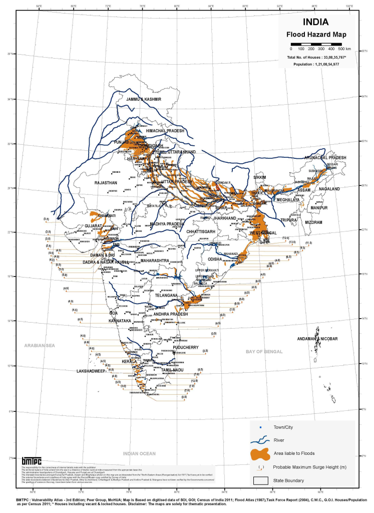
3. Flood, urban flooding, and river erosion vulnerability
Flooding is one of India’s most recurrent and widespread hazards. Riverine floods affect the Ganga, Brahmaputra, Meghna, Mahanadi, Godavari, Krishna, Narmada, Tapi, Cauvery, and other river systems, while flash floods affect Himalayan and hilly catchments. Urban flooding is increasing due to intense rainfall, drainage congestion, loss of wetlands, encroachment of floodplains, solid-waste blockage, and rapid urban expansion.
Flood vulnerability is especially high in:
| Risk zone | Main flood-risk pathways |
|---|---|
| Indo-Gangetic plains | River overflow, embankment stress, erosion, waterlogging, crop losses |
| Brahmaputra basin and Northeast India | River flooding, flash floods, erosion, landslides, transport disruption |
| Coastal states | Cyclone rainfall, storm surge, tidal flooding, sea-level rise |
| Himalayan states | Cloudbursts, flash floods, landslides, glacial lake outburst floods |
| Major cities | Urban drainage failure, pluvial flooding, informal settlement exposure |
Floods damage housing, crops, roads, bridges, schools, health facilities, irrigation systems, power infrastructure, and drinking-water systems. They also increase risks of waterborne diseases, displacement, livelihood loss, and post-disaster debt.
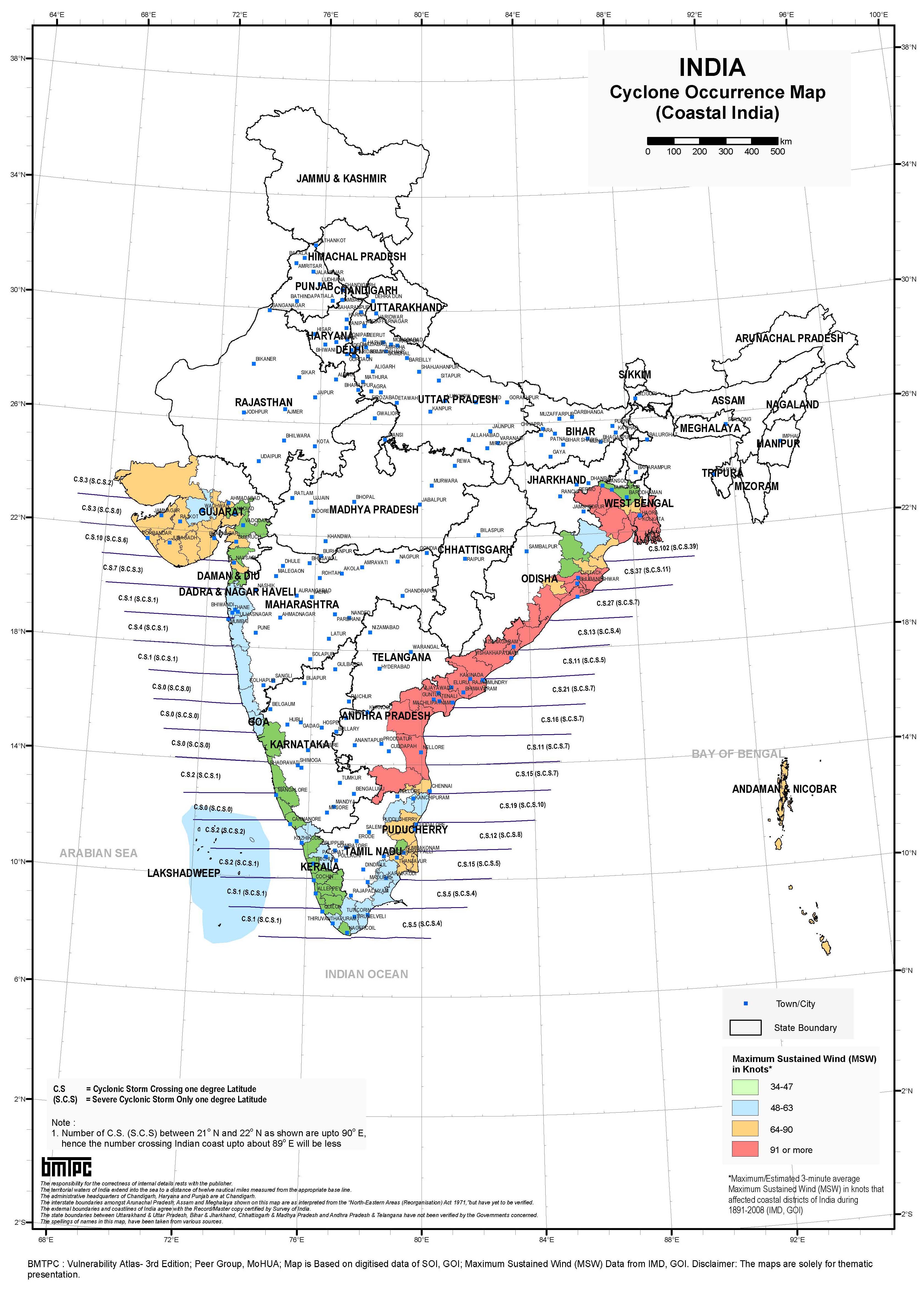
4. Cyclone, storm surge, and coastal vulnerability
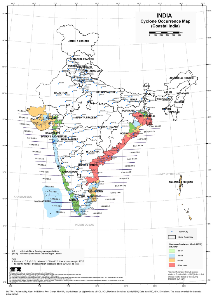
India’s eastern and western coastlines are exposed to cyclones, storm surge, coastal flooding, erosion, sea-level rise, salinity intrusion, and tsunamis. The Bay of Bengal coast is particularly cyclone-prone, with high exposure in Odisha, West Bengal, Andhra Pradesh, Tamil Nadu, and the Andaman and Nicobar Islands. The Arabian Sea coast, including Gujarat, Maharashtra, Goa, Karnataka, Kerala, and Lakshadweep, also faces cyclone and coastal-risk concerns.
NDMA states that about 5,700 km of India’s 7,516 km coastline is prone to cyclones and tsunamis. (NDMA) Coastal risk is not only a physical hazard; it directly affects fisheries, ports, tourism, coastal agriculture, saline-prone water systems, mangroves, coastal roads, housing, and critical infrastructure.
5. Heatwave and public-health vulnerability
Heatwaves are becoming one of India’s most serious climate risks. Heat stress affects health, labour productivity, agriculture, water demand, electricity demand, urban living conditions, and outdoor work. Risks are highest for outdoor workers, construction workers, farmers, street vendors, traffic police, informal labourers, elderly people, children, pregnant women, people with chronic illness, and residents of poorly ventilated housing or informal settlements.
Heat risk is particularly severe in northwestern, central, eastern, and peninsular India, including parts of Rajasthan, Gujarat, Maharashtra, Madhya Pradesh, Uttar Pradesh, Bihar, Jharkhand, Odisha, Telangana, Andhra Pradesh, and Tamil Nadu. Climate change increases the probability of compound events where heat combines with drought, water scarcity, air pollution, wildfire smoke, or power outages.
6. Drought, water security, and agricultural vulnerability
Drought is a major risk because large parts of India depend on monsoon rainfall, groundwater, irrigation systems, and seasonal water storage. NDMA reports that 68% of India’s cultivable area is vulnerable to drought. (NDMA) Drought-prone regions include parts of Rajasthan, Gujarat, Maharashtra, Karnataka, Andhra Pradesh, Telangana, Madhya Pradesh, Chhattisgarh, Odisha, Bundelkhand, and the Deccan Plateau.
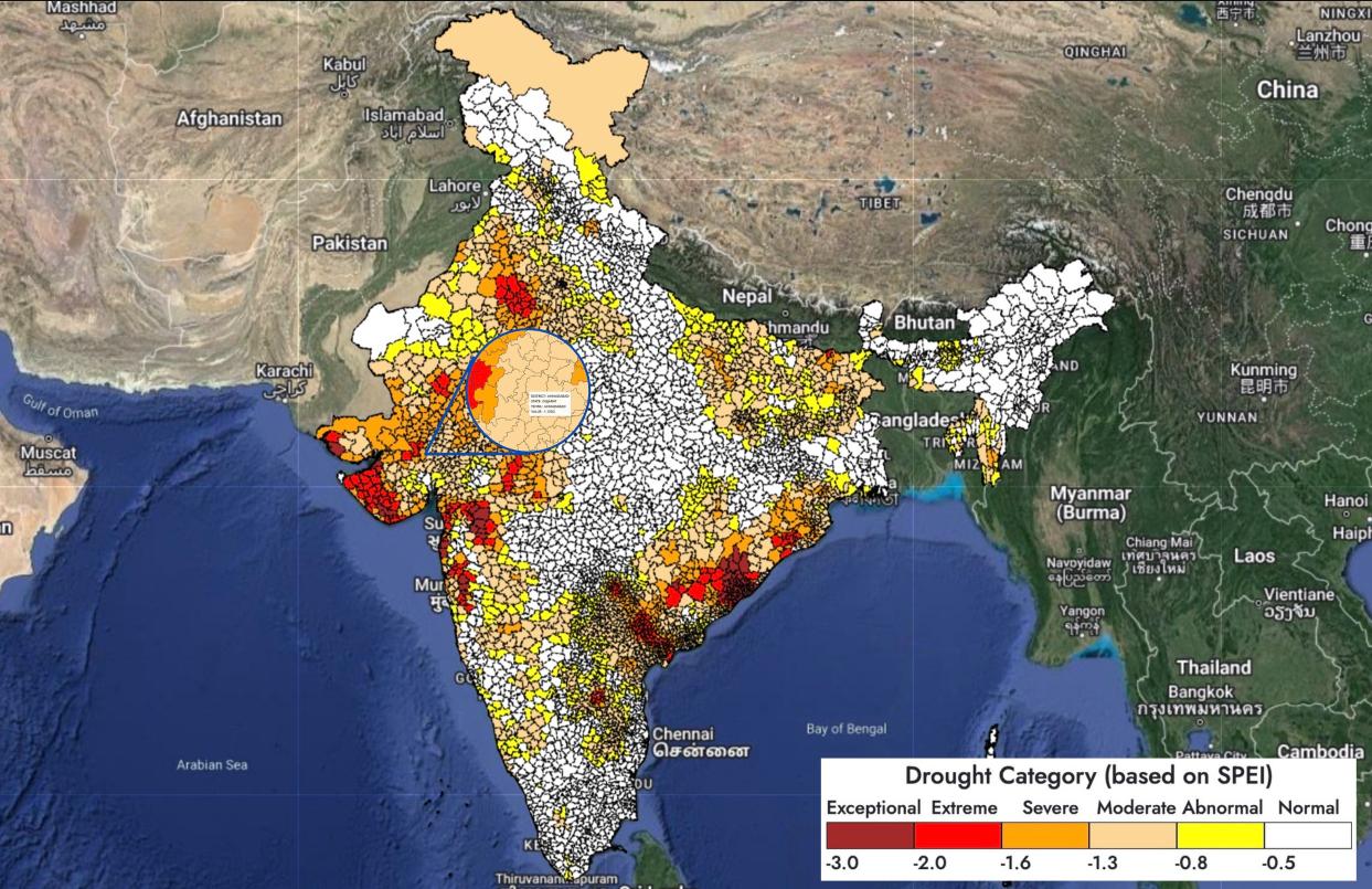
Source : Drought Atlas of India
Agriculture is highly climate-sensitive. Climate risks include:
| Agricultural system | Main climate risks |
|---|---|
| Rainfed farming | Monsoon variability, dry spells, crop failure, low soil moisture |
| Irrigated agriculture | Groundwater depletion, heat stress, power demand, canal-water stress |
| Rice and wheat systems | Heat stress, flood damage, crop-calendar disruption, water stress |
| Millets, pulses, oilseeds | Drought, rainfall variability, pest and disease shifts |
| Livestock | Heat stress, fodder shortage, water scarcity, disease outbreaks |
| Fisheries and aquaculture | Cyclones, marine heatwaves, salinity shifts, coastal flooding |
Climate shocks in agriculture can affect food security, rural employment, farm debt, migration, nutrition, and market prices.
7. Himalayan and mountain-system vulnerability
The Himalayan region faces a distinct set of climate and geophysical risks, including earthquakes, landslides, avalanches, flash floods, cloudbursts, glacial lake outburst floods, snowpack changes, glacier retreat, and river-flow variability. These risks are particularly important in Jammu and Kashmir, Ladakh, Himachal Pradesh, Uttarakhand, Sikkim, Arunachal Pradesh, and other northeastern hill states.
Mountain hazards can damage roads, hydropower infrastructure, bridges, settlements, tourism assets, military and border infrastructure, water systems, and rural livelihoods. Climate change can intensify slope instability, alter snow and glacier melt, increase extreme rainfall, and create new risks in high-altitude catchments.
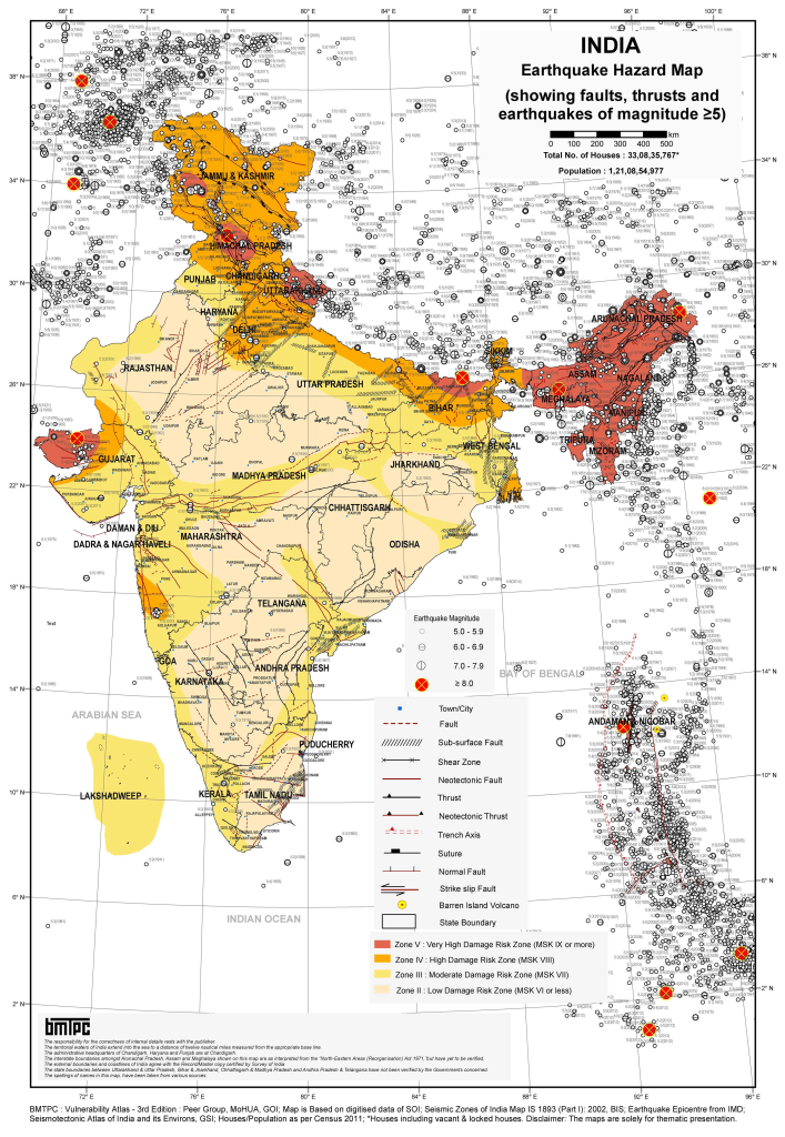
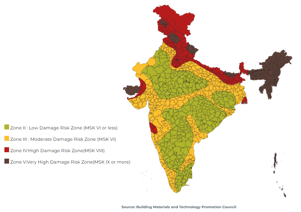
8. Earthquake, tsunami, and landslide vulnerability
India’s seismic risk is substantial, with 58.6% of landmass prone to earthquakes of moderate to very high intensity. (NDMA) High-risk seismic zones include the Himalayan belt, Northeast India, parts of Gujarat, the Andaman and Nicobar Islands, and other fault-affected regions.
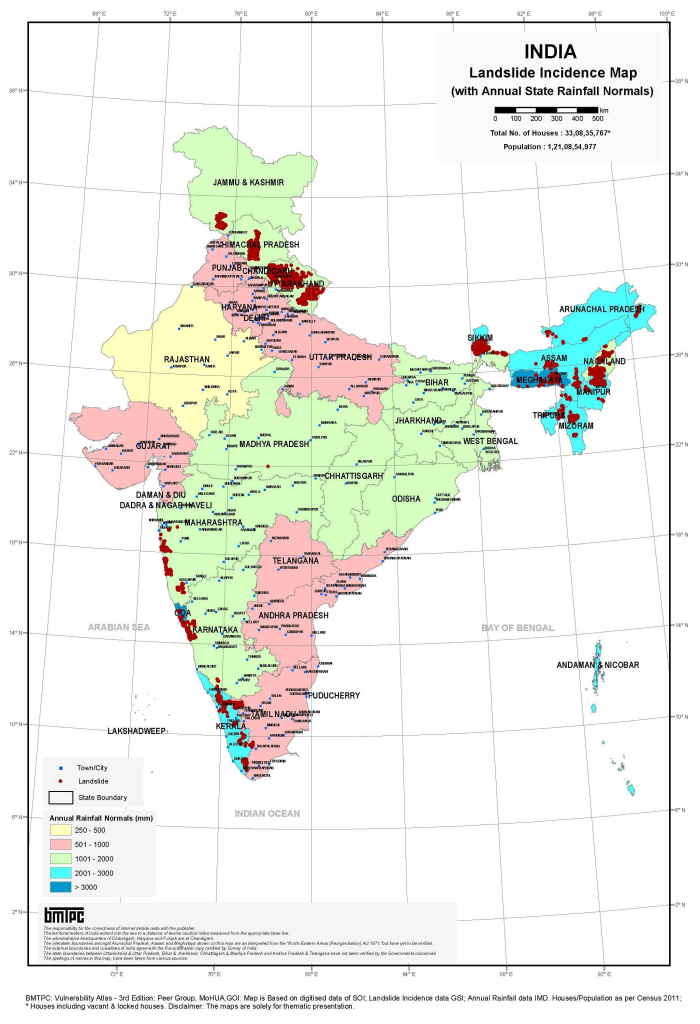
Landslides affect the Himalayas, Northeast India, Western Ghats, Eastern Ghats, and other hilly regions. They are triggered by intense rainfall, earthquakes, slope cutting, road construction, deforestation, poor drainage, and unplanned settlement expansion. Tsunami risk affects the Andaman and Nicobar Islands and parts of India’s eastern and western coasts.
9. Urban climate and infrastructure vulnerability
India’s cities face rapidly increasing climate risk due to urban flooding, heat stress, water scarcity, air pollution, drainage failure, informal settlement growth, coastal exposure, and infrastructure stress. Major cities such as Mumbai, Chennai, Kolkata, Delhi, Bengaluru, Hyderabad, Ahmedabad, Surat, Guwahati, Patna, Kochi, Visakhapatnam, and Bhubaneswar face different combinations of flood, heat, cyclone, water, coastal, and seismic risks.
Urban vulnerability is highest where climate hazards overlap with:
| Vulnerability driver | Risk implication |
|---|---|
| Informal settlements | Poor drainage, weak housing, insecure tenure, limited recovery capacity |
| High-density built-up areas | Urban heat-island effects, drainage congestion, emergency-access limits |
| Aging infrastructure | Water, sewerage, roads, power, and transport disruption |
| Coastal expansion | Sea-level rise, storm surge, erosion, salinity intrusion |
| Low-income households | Limited savings, insurance, cooling access, and evacuation options |
10. Sector-specific vulnerability summary
| Sector | Main climate and hazard risks |
|---|---|
| Agriculture and food security | Drought, floods, heat stress, pests, crop-calendar disruption, water scarcity |
| Water resources | Groundwater depletion, drought, flood contamination, glacier/snowpack change, salinity intrusion |
| Coastal zones | Cyclones, storm surge, sea-level rise, erosion, tsunamis, saline intrusion |
| Urban settlements | Heatwaves, urban floods, drainage failure, water scarcity, informal settlement exposure |
| Health | Heat illness, vector-borne disease, waterborne disease, malnutrition, air pollution, disaster trauma |
| Transport infrastructure | Flooded roads, bridge damage, landslides, cyclone damage, heat-related asset stress |
| Energy | Hydropower variability, cooling demand, grid stress, storm damage, water constraints |
| Forests and ecosystems | Wildfire, drought stress, biodiversity loss, invasive species, ecosystem degradation |
| Tourism and cultural heritage | Heat, floods, landslides, coastal erosion, glacier and mountain hazards |
11. Social vulnerability
India’s climate vulnerability is deeply shaped by social and economic inequalities. The most vulnerable groups include smallholder and marginal farmers, landless labourers, fisherfolk, pastoralists, informal workers, urban slum residents, women-headed households, children, older persons, people with disabilities, Indigenous and tribal communities, coastal communities, mountain communities, migrants, and people living in drought-prone, flood-prone, heat-prone, cyclone-prone, landslide-prone, or seismic zones.
Vulnerability is highest where exposure overlaps with poverty, insecure housing, limited access to safe water and sanitation, weak health access, low insurance coverage, limited mobility, informal employment, and weak last-mile early warning.
12. Priority resilience needs
India’s resilience agenda should prioritize multi-hazard early warning systems, impact-based forecasting, heat-health action plans, flood and cyclone preparedness, drought monitoring, glacial lake and landslide risk monitoring, climate-resilient agriculture, coastal-zone management, resilient urban drainage, water-security planning, earthquake-safe construction, resilient infrastructure, ecosystem-based adaptation, disaster risk financing, and shock-responsive social protection.
A practical resilience package for India should include:
| Priority area | Key actions |
|---|---|
| Early warning and anticipatory action | Impact-based warnings for floods, cyclones, heat, drought, landslides, lightning, and coastal inundation |
| Coastal resilience | Cyclone shelters, storm-surge mapping, mangrove restoration, resilient ports, saline-water management |
| Flood and river management | Basin-scale forecasting, floodplain zoning, erosion management, resilient embankments, wetland restoration |
| Heat-risk management | Heat Action Plans, cool roofs, urban greening, occupational safety, cooling centres, health surveillance |
| Climate-resilient agriculture | Drought-, flood-, heat-, and salinity-tolerant crops; agro-advisories; insurance; water-saving irrigation |
| Urban resilience | Drainage upgrading, blue-green infrastructure, risk-informed zoning, slum upgrading, resilient water systems |
| Mountain resilience | Landslide mapping, glacial lake monitoring, slope stabilization, resilient roads, safe hydropower planning |
| Disaster risk financing | Contingency funds, insurance, forecast-based financing, scalable social protection, resilient recovery finance |
National Disaster Management Authority (India)
The National Disaster Management Authority (NDMA), headed by the Prime Minister of India, is the apex body for Disaster Management in India. Setting up of NDMA and the creation of an enabling environment for institutional mechanisms at the State and District levels is mandated by the Disaster Management Act, 2005.

NDMA is mandated to lay down the policies, plans and guidelines for Disaster Management to ensure timely and effective response to disasters. Towards this, it has the following responsibilities:
- Lay down policies on disaster management;
- Approves the National Plan;
- Approve plans prepared by the Ministries or Departments of the Government of India in accordance with the National Plan;
- Lay down guidelines to be followed by the State Authorities in drawing up the State Plan;
- Lay down guidelines to be followed by the different Ministries or Departments of the Government of India for the purpose of integrating the measures for prevention of disaster or the mitigation of its effects in their development plans and projects;
- Coordinate the enforcement and implementation of the policy and plans for disaster management;
- Recommend provision of funds for the purpose of mitigation;
- Provide such support to other countries affected by major disasters as may be determined by the Central Government;
- Take such other measures for the prevention of disaster, or the mitigation, or preparedness and capacity building for dealing with threatening disaster situations or disasters as it may consider necessary;
- Lay down broad policies and guidelines for the functioning of the National Institute of Disaster Management.
NDMA also equips and trains other Government officials, institutions and the community in mitigation for and response during a crisis situation or a disaster. It works closely with the National Institute of Disaster Management for capacity building. It develops practices, delivers hands-on training and organises drills for disaster management. It also equips and trains disaster management cells at the state and local levels.
NDMA, under the Ministry of Home Affairs can also be assigned with the responsibility for protection of cyber critical infrastructure. As a result NDMA has overlapping responsibilities with CERT-IN of MeitY and NCIIPC of the NTRO when it comes to securing critical/non-critical infrastructure.
NDMA developed guidelines
The following are the guidelines as per NDMA’s official website:
- Guidelines for Preparation of Action Plan – Prevention and Management of Heat Wave
- Landslide Risk Management Strategy
- Guidelines on Disability Inclusive Disaster Risk Reduction
- Guidelines on Temporary Shelters for Disaster-Affected Families
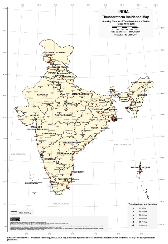
- Guidelines on Prevention & Management of Thunderstorm & Lightning/Squall/Dust/Hailstorm & Strong Winds
- Guidelines on Boat Safety
- Guidelines on Cultural Heritage Sites and Precincts
- Guidelines on Museums
- Guidelines on Minimum Standards of Relief
- Guidelines on Hospital Safety
- Guidelines on School Safety Policy
- Guidelines on Seismic Retrofitting of Deficient Buildings and Structures
- Guidelines on Scaling, Type of Equipment and Training of Fire Services
- Guidelines on National Disaster Management Information and Communication System
- Guidelines on Management of Drought
- Guidelines on Management of Urban Flooding
- Guidelines on Management of Dead in the Aftermath of Disaster
- Guidelines on Management of Tsunamis
- Guidelines on Incident Response System
- Guidelines on Psycho-Social Support and Mental Health Services in Disasters
- Guidelines on Management of Chemical(Terrorism) Disasters
- Guidelines on Management of Landslides and Snow Avalanches
- Guidelines on Management of Nuclear and Radiological Emergencies
- Guidelines on Management of Biological Disasters
- Guidelines on Management of Cyclones
- Guidelines on Management of Floods
- Guidelines on Medical Preparedness and Mass Casualty Management
- Guidelines on Preparation of State Disaster Management Plans
- Guidelines on Chemical Disasters
- Guidelines on Management of Earthquakes


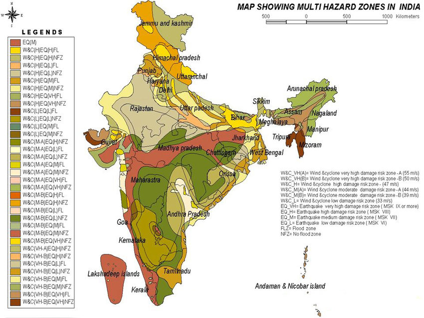
Multi-hazard Phenomena of India
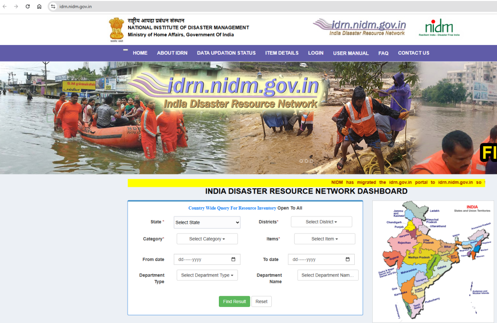
Out of the 36 States and Union Territories in India, 27 are hazard-prone, with about 58.6% of the landmass being prone to earthquakes, 12% to flooding, and 15% to landslides, respectively . Out of 7516 km of coast, 5700 km are vulnerable to cyclones and tsunamis
https://imdpune.gov.in/hazardatlas/floodnew.html
https://imdpune.gov.in/hazardatlas
It is strongly advisable to the Nodal agency, NDMA, that your website is running very slowly, and users can hardly access online resources at https://ndma.gov.in. Please optimize your portal with a high-configured server and high-speed internet bandwidth, as this is a national priority.
https://ndma.gov.in/Governance/Guidelines
Hydromet Observation Infrastructures in India
- India Meteorological Department (IMD) Doppler Weather Radar (DWR) Network … In QGIS, these maps are visualized along with the IMD DWR network.
IMD DWR Network
| S No | DWR Station | State | Type of DWR |
| 1 | Agartala | Tripura | S – Band |
| 2 | Bhopal | Madhya Pradesh | S – Band |
| 3 | Bhuj | Gujarat | S – Band |
| 4 | Chennai | Tamil Nadu | S – Band |
| 5 | Cherrapunjee (ISRO) | Meghalaya | S – Band |
| 6 | Delhi (Palam) | Delhi | S – Band |
| 7 | Panaji | Goa | S – Band |
| 8 | Gopalpur | Odisha | S – Band |
| 9 | Hyderabad | Telangana | S – Band |
| 10 | Jaipur | Rajasthan | C – Band |
| 11 | Kolkata | West Bengal | S – Band |
| 12 | Kochi | Kerala | S – Band |
| 13 | Karaikal | Tamil Nadu | S – Band |
| 14 | Lucknow | Uttar Pradesh | S – Band |
| 15 | Machilipatnam | Andhra Pradesh | S – Band |
| 16 | Mohanbari | Assam | S – Band |
| 17 | Mumbai | Maharashtra | S – Band |
| 18 | Nagpur | Maharashtra | S – Band |
| 19 | New Delhi (Mausam Bhawan) | Delhi | C – Band |
| 20 | Paradip | Odisha | S – Band |
| 21 | Patiala | Punjab | S – Band |
| 22 | Patna | Bihar | S – Band |
| 23 | Srinagar | Jammu and Kashmir | X – Band |
| 24 | Thiruvananthapuram (ISRO) | Kerala | C – Band |
| 25 | Visakhapatnam | Andhra Pradesh | S – Band |
Met Stations

Dynamic Prediction of Lightning Flash Count
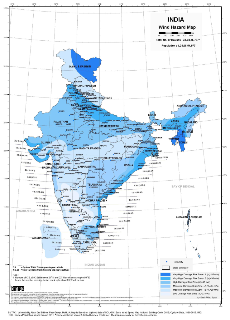
Wind Hazard Map
Earthquake Hazard prone area Map
Flood Prone Area Hazard Map
Landsline hazard prone area
Cyclone vulnerable area
Earthqhake Hazard Prone area
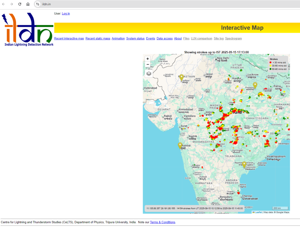
Indian Lighting Detection Network
Indian ISRO Running Essential Climate Variables (ECV) Visualization Geoportal ( Realtime Visualization )
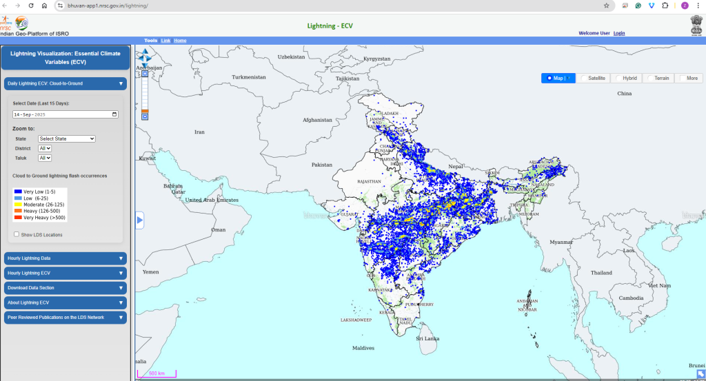
INDIAN INSTITUTE OF REMOTE SENSING– Indian Space Research Organisation
Expert comments :