Climate risk and vulnerabilities of Panama
Riesgos climáticos y vulnerabilidades de Panamá
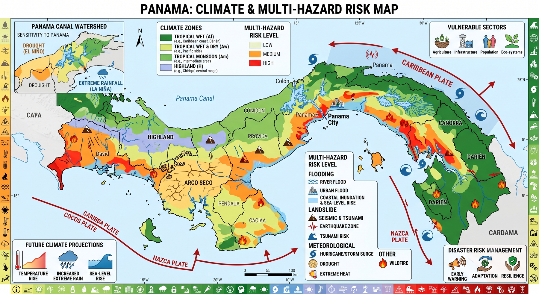
Climate risk and vulnerabilities of Panama
Panama is exposed to a complex climate and multi-hazard risk environment shaped by its tropical rainfall regime, Pacific and Caribbean coastlines, mountainous terrain, dense river networks, the Panama Canal watershed, rapidly urbanizing settlements, and dependence on climate-sensitive sectors such as water, agriculture, tourism, transport, energy, forests, and coastal ecosystems.
Panama is highly vulnerable to climate change and multi-hazard risks, including floods, landslides, droughts, tropical storms, hurricanes, windstorms, wildfires, earthquakes, tsunamis, coastal erosion, and sea-level rise. Floods and landslides are among the most destructive recurrent hazards during the rainy season, while climate change is expected to increase temperatures, extreme rainfall, dry-season stress, drought frequency, coastal inundation, and risks to water security. These hazards threaten communities, housing, roads, agriculture, tourism, public health, biodiversity, coastal settlements, and critical economic systems, including the Panama Canal watershed. Strengthening multi-hazard early warning systems, climate-resilient infrastructure, integrated water-resource management, coastal adaptation, watershed protection, risk-informed urban planning, and disaster risk financing is essential for reducing Panama’s future climate and disaster losses.

1. Multi-hazard exposure
Panama faces both hydrometeorological and geophysical hazards. Key hazards include floods, landslides, droughts, hurricanes, tropical storms, windstorms, wildfires, earthquakes, tsunamis, and ENSO-related climate variability. The Adaptation Fund describes Panama as highly vulnerable to climate impacts and notes its exposure to intense and prolonged rainfall, floods, droughts, wildfires, earthquakes, landslides, tropical cyclones, tsunamis, and El Niño/La Niña events. (Adaptation Fund)
Floods and landslides are particularly recurrent. GFDRR notes that during Panama’s rainy season, generally from May to November, floods and landslides are the most destructive natural disasters, affecting communities, agriculture, roads, and housing.
2. Climate change as a risk multiplier
Climate change is expected to intensify Panama’s climate-risk profile. The World Bank’s 2024 climate risk profile states that Panama is likely to experience higher minimum and maximum temperatures by midcentury, with more frequent extreme precipitation events. It also identifies risks to food security, flood safety, disease ranges, biodiversity, and living conditions. (PreventionWeb)
Future risks are spatially differentiated. Sea-level rise and coastal inundation are expected to increasingly threaten Panama’s Caribbean coast and parts of the Pacific coast, while intense floods and droughts associated with ENSO are expected to become more common. These are especially important for the Panama Canal watershed and the Arco Seco, respectively. (PreventionWeb)
3. Water security and Panama Canal vulnerability
Water security is one of Panama’s most strategic climate vulnerabilities. Drought, longer dry seasons, rainfall variability, and watershed degradation affect drinking water, agriculture, hydropower, ecosystems, and canal operations. The World Bank notes that Panama is particularly vulnerable to hydroclimatic threats such as floods, longer dry seasons, and sea-level rise, and highlights water-dependent sectors, including the Panama Canal, as exposed to climate risk. (World Bank)
The Panama Canal watershed is especially important because disruption to rainfall, reservoir storage, and water availability can have national and international economic implications. Climate-related drought can reduce operational reliability, while extreme rainfall can increase flood, landslide, sedimentation, and infrastructure risks in the wider watershed.
4. Flood, landslide, and urban vulnerability
Flooding and landslides are among Panama’s most visible and recurring climate-related hazards. Heavy rainfall, steep slopes, river overflow, poor drainage, land-use change, and settlement expansion in hazard-prone locations increase exposure. A 2024 study of Panama’s urban climate risk found that floods, landslides, and extreme winds were the main recorded impacts; from 1933 to 2019, Panama recorded 1,903 flood reports and 625 landslide reports, affecting 527,394 people and 101,738 homes, with Panama, Panama Oeste, and Chiriquí among the most affected provinces. (MDPI)
Urban areas are vulnerable where intense rainfall overlaps with informal settlements, inadequate drainage, exposed transport corridors, unstable slopes, riverbanks, and aging infrastructure. This creates cascading risks for housing, roads, bridges, schools, health facilities, markets, water systems, and emergency response access.
5. Coastal and island vulnerability
Panama’s long coastlines and many islands create high exposure to sea-level rise, storm surge, coastal erosion, saltwater intrusion, coastal flooding, mangrove degradation, and displacement risks. UNEP notes that Panama has almost 3,000 km of coastline and around 1,500 islands, making sea-level rise a significant threat. (UNEP – UN Environment Programme)
Coastal and island communities, including Indigenous communities in Guna Yala, face increasing risks from recurrent flooding, erosion, storms, saltwater intrusion, and eventual relocation pressures. A 2024 report cited by Newsweek, developed by Panama’s Ministry of Environment using IPCC data, estimated that 2.01% of Panama’s total land area could be at risk of coastal flooding by 2050. (Newsweek)
6. Sector-specific vulnerabilities
| Sector | Main climate and hazard risks |
|---|---|
| Water resources and Panama Canal watershed | Drought, longer dry seasons, rainfall variability, reservoir stress, flood and sedimentation risk |
| Agriculture and food security | Drought, intense rainfall, crop damage, soil erosion, pests, reduced productivity |
| Urban settlements | Flooding, poor drainage, landslides, extreme winds, heat stress, informal settlement exposure |
| Transport infrastructure | Road washouts, bridge damage, landslides, slope instability, flood disruption |
| Coastal zones and islands | Sea-level rise, storm surge, coastal erosion, saltwater intrusion, displacement pressure |
| Tourism | Coastal damage, beach erosion, water stress, extreme weather disruption, ecosystem degradation |
| Health | Heat stress, waterborne disease, vector-borne disease expansion, disaster-related service disruption |
| Ecosystems and biodiversity | Mangrove loss, forest degradation, wildfire, biodiversity loss, watershed degradation |
7. Social vulnerability
The most vulnerable groups include low-income urban households, informal settlers, rural communities, smallholder farmers, Indigenous peoples, coastal and island communities, women-headed households, older persons, children, people with disabilities, and communities dependent on climate-sensitive livelihoods. Vulnerability is highest where exposure to floods, landslides, drought, or coastal hazards overlaps with poor housing, limited savings, weak access to services, insecure land tenure, and limited disaster-risk insurance.
8. Priority resilience needs
Panama’s resilience agenda should prioritize multi-hazard early warning systems, flood and landslide forecasting, drought monitoring, climate-resilient water management, Panama Canal watershed protection, resilient urban drainage, slope stabilization, coastal-zone management, mangrove and watershed restoration, climate-smart agriculture, risk-informed land-use planning, resilient transport infrastructure, and disaster risk financing.
The Government of Panama launched a National Adaptation Plan project in 2023 with support from the Green Climate Fund and UNEP to strengthen adaptation governance, climate-risk knowledge, and thematic adaptation planning in water resources, agriculture and food security, infrastructure, and health. (UNEP – UN Environment Programme)

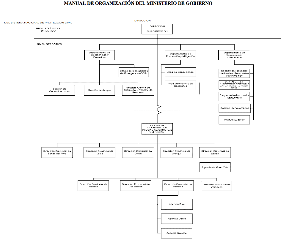
Aprobado, según Nota: DIPRENA/DOE/No.2509 del 13 de diciembre de 2013, Departamento de Organización del Estado de la Dirección de Presupuesto de la Nación, del Ministerio de Economía y Finanzas.
Misión
- Somos un organismo humanitario, encargado de ejecutar disposiciones y órdenes, tendientes a prevenir, mitigar, preparar y proteger a la población panameña sobre los efectos que la acción de la naturaleza o la antropogénica pueda provocar sobre la vida y bienes del conglomerado social.
- Le corresponde al Sinaproc la planificación, investigación, dirección, supervisión y organización de las políticas y acciones hacia la prevención de riesgos materiales y psicosociales, lo cual ejercerá las siguientes funciones:
- Recopilar y mantener un sistema de información, a través de un centro de datos moderno, cuya finalidad es obtener y ofrecer informaciones necesarias para la planificación de estrategias y medidas sobre gestión integral de riesgo y protección civil.
Visión
Promover un Plan de Modernización y Capacitación para la Prevención y Mitigación ante Emergencias, incorporando como eje un esquema trasversal en los procesos y planes de manejo integral de riesgo; con el objetivo de reducir las vulnerabilidades existentes y el impacto de los desastres en todo el territorio nacional.