South Korea Climate, Multi-Hazard Disaster Risk And Vulnerability
1. Country risk overview
South Korea, officially the Republic of Korea, is a highly developed, highly urbanized, and technologically advanced country, but it is increasingly exposed to climate-amplified disaster risks. Its risk profile is shaped by a peninsular geography, dense coastal and urban development, mountainous terrain, seasonal monsoon rainfall, western North Pacific typhoons, aging demographics, and extensive critical infrastructure concentrated in metropolitan and coastal industrial corridors.
South Korea’s national adaptive capacity is high by global comparison: ND-GAIN classifies the Republic of Korea as the 157th most vulnerable country and the 3rd most ready country, indicating relatively low national vulnerability and strong capacity to mobilize adaptation investment. However, this national ranking masks high localized exposure in flood-prone urban basements, steep mountain valleys, coastal industrial zones, forest–settlement interfaces, and aging rural communities. (gain-new.crc.nd.edu)
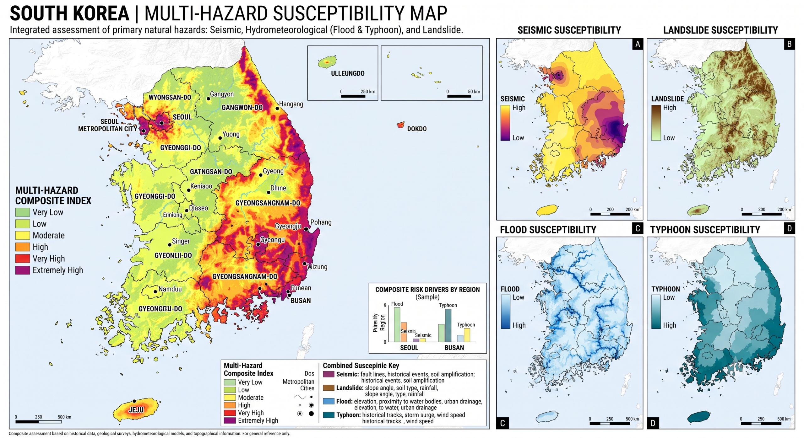
2. Climate context and climate-change trends
South Korea has a temperate monsoon climate with four distinct seasons. Summer is humid under the influence of the North Pacific High, while winter is cold and dry due to continental anticyclones. Around 50–60% of annual precipitation occurs during the summer monsoon season, creating strong seasonal flood risk, while the remaining seasons can experience drought conditions. The country is also physically exposed because around three-quarters of its land is mountainous, with lowlands concentrated in the west and south and coastlines exposed on three sides.
Observed climate change is already significant. The Government of the Republic of Korea reports that average annual temperature increased by about 1.6°C during 1912–2020, exceeding the global average warming of 1.09°C over a comparable period. Sea surface temperature rose by 1.23°C during 1968–2017, and sea level rose by about 2.97 mm per year during 1989–2018. Heavy rain, heatwaves, abnormal winter warmth, and cold waves have increased damages and casualties, while climate-related natural disasters caused around KRW 3.7 trillion in economic losses during 2011–2021, with recovery costs estimated at two to three times the direct losses.
Future projections show increasing climate stress. Korea’s Adaptation Communication projects annual temperature increases of 1.8–4.7°C by the end of the 21st century, depending on scenario, and annual precipitation increases of 5.5–13.1%. The subtropical climate zone, currently limited mainly to the southern coast, is expected to expand, increasing heatwave days, tropical nights, and high-temperature extremes.
The recent climate record confirms this direction. KMA analysis of South Korea’s 2024 summer found an average summer temperature of 25.6°C, ranked first and 1.9°C above normal; 20.2 tropical nights, ranked first; and 24 heatwave days, ranked third. Jangma monsoon rainfall reached 474.8 mm, representing 78.8% of summer precipitation, also ranked first, illustrating the growing compound pattern of heavy rainfall, humid nights, and heat stress. (ds.data.jma.go.jp)
3. National multi-hazard profile
ThinkHazard classifies the Republic of Korea as having high hazard levels for urban flood, coastal flood, landslide, cyclone, wildfire, and volcano; medium hazard levels for tsunami and extreme heat; and lower national levels for river flood, earthquake, and water scarcity. These national ratings should be interpreted carefully because local risk can be much higher than the national average, especially in Seoul, Busan, Jeju, Gangwon, Gyeongsang, and coastal industrial zones. (thinkhazard.org)
| Hazard | Risk level and vulnerability pattern |
|---|---|
| Urban flooding | One of the most critical risks. Intense rainfall overwhelms drainage systems, subways, underpasses, underground roads, basements, and low-lying neighborhoods. Seoul, Incheon, Busan, Daegu, Daejeon, Gwangju, and other dense cities are key hotspots. |
| River and flash flooding | Although national river-flood hazard is rated low by ThinkHazard, flood impacts are severe when monsoon rainfall, saturated soils, dam releases, tributary flooding, and landslides combine. Han, Nakdong, Geum, Yeongsan, and Seomjin basins require basin-scale risk management. |
| Typhoons and storm rainfall | Western North Pacific typhoons produce storm surge, high waves, extreme rainfall, wind damage, landslides, and port/industrial disruption. Jeju, the south coast, Busan, Ulsan, Pohang, Gyeongnam, Jeonnam, and eastern coastal areas are highly exposed. |
| Landslides and debris flows | High risk because mountainous terrain, steep slopes, cut roads, forest roads, deforestation patches, construction, and intense rainfall interact. Landslide risk is especially acute in Gangwon, North/South Gyeongsang, North/South Chungcheong, Jeolla mountain zones, and peri-urban slopes. |
| Heatwaves and tropical nights | Rapidly increasing, especially in cities. Urban heat island effects, aging, outdoor work, poor housing, low income, chronic disease, and limited cooling access increase mortality and morbidity risk. |
| Wildfire | A growing climate-amplified risk, especially in eastern and southeastern forested regions, including Gangwon and Gyeongsang. Dry spring winds, low humidity, high fuel loads, forest–settlement interfaces, and aging rural populations increase vulnerability. |
| Drought and water scarcity | National water-scarcity hazard is lower than many countries, but seasonal and regional droughts affect reservoirs, agriculture, hydropower, urban water supply, ecosystems, and wildfire danger, particularly during dry winter–spring periods and in southern regions. |
| Coastal flooding, sea-level rise and erosion | High risk along low-lying reclaimed lands, ports, fishery harbors, tidal flats, coastal cities, and industrial corridors. Compound flooding occurs when storm surge, high tides, heavy rain, river discharge, and drainage blockage overlap. |
| Earthquakes | National earthquake hazard is lower than Japan or Taiwan, but moderate earthquakes such as the 2016 Gyeongju and 2017 Pohang events revealed infrastructure and public-preparedness vulnerabilities. |
| Tsunami and volcanic hazards | Tsunami risk is medium, mainly for the east coast from offshore seismic sources. Volcanic hazard is low-frequency but relevant for Jeju, Ulleungdo, and broader Northeast Asian volcanic ash scenarios. |
4. Flood, monsoon and landslide risk
Flooding is South Korea’s most damaging recurrent hazard. Heavy rainfall during the Jangma monsoon, typhoon rainfall, localized convective storms, saturated catchments, and urban drainage constraints create severe pluvial, flash-flood, and landslide risk. ADRC identifies typhoons, torrential rains, floods, heavy snowfall, landslides, storms, drought, and heatwaves as major disasters in Korea. (adrc.asia)
The July 2023 heavy-rain disaster illustrates the national risk pattern. ADRC reports that the event caused 50 fatalities, numerous landslides, evacuation of more than 10,000 people, and major damage to infrastructure, including the Osong underground roadway flooding disaster in Cheongju. The 2020 monsoon also produced record-breaking rainfall over a prolonged period, with 42 consecutive days of rain, fatalities, displacement, flooding, and landslides. (adrc.asia)
Urban flood vulnerability is particularly acute where people and assets are concentrated below grade. Semi-basement housing, underground transport, underpasses, basement shops, underground parking, power substations, data centers, metro stations, and drainage tunnels can become lethal during short-duration extreme rainfall. Research by the Architecture & Urban Research Institute found 185,518 disaster-prone basement housing units nationwide, with 92.2% located in the Seoul metropolitan area, including Seoul, Gyeonggi, and Incheon. (건축공간연구원)
5. Typhoon and coastal compound risk
South Korea’s typhoon risk is not only a wind hazard; it is a compound coastal and hydrometeorological hazard. Typhoons can bring extreme rainfall, storm surge, wave overtopping, river backwater effects, landslides, power disruption, port closure, transport interruption, and industrial downtime. The southern coast, Jeju Island, Busan, Ulsan, Pohang, Gyeongnam, Jeonnam, and coastal industrial belts face the highest combined exposure.
Sea-level rise is increasing baseline coastal risk. The Adaptation Communication reports that Korean sea level rose faster than the global average during 1989–2018, while coastal areas face increased disaster risk, including flooding and tsunami due to sea-level rise. Coastal industrial complexes, ports, petrochemical facilities, shipyards, fisheries, aquaculture, beaches, tourism zones, bridges, and power plants are all exposed to compound coastal flooding.
6. Heatwave, health and urban vulnerability
Heat risk is rising rapidly. Heatwaves affect public health, labor productivity, outdoor construction and agriculture workers, elderly people living alone, low-income households, people with chronic illness, schools, hospitals, and care facilities. Tropical nights are particularly dangerous because they reduce overnight recovery from heat stress.
ADRC reports that the summer 2022 heatwave caused 34 deaths, exceeding the flood fatality toll that year, while KMA’s 2024 summer analysis showed record tropical nights and very high heatwave-day counts. (adrc.asia) South Korea’s demographic profile heightens this risk: the country entered a super-aged society around 2024, with more than 20% of the population over 65, and older adults are more sensitive to heat, smoke, evacuation constraints, and post-disaster recovery stress. (Carnegie Endowment)
Urban heat is amplified by impervious surfaces, high-rise density, traffic corridors, low vegetation cover, waste heat from buildings, and high nighttime humidity. Seoul, Daegu, Daejeon, Gwangju, Busan, Incheon, and industrial cities are priority areas for heat-health early warning, cooling centers, shaded mobility routes, green-blue infrastructure, and household-level protection.
7. Wildfire and forest–settlement interface risk
Wildfire is becoming a major climate-sensitive hazard. The March 2025 southeastern Korea wildfires were described by World Weather Attribution as South Korea’s largest and most destructive wildfires on record, with more than 48,000 hectares burned, 32 deaths, 45 injuries, around 37,000 residents displaced, and severe impacts on residential, industrial, agricultural, and heritage sites. Most victims were older adults, and Uiseong was among the hardest-hit areas. (World Weather Attribution)
Climate change has increased the fire-weather signal. World Weather Attribution found that the hot, dry and windy conditions behind the 2025 wildfires became about 15% more intense and roughly twice as likely due to human-induced climate change. The study also emphasized the need to manage fuel loads near settlements, integrate wildfire planning with land-use and infrastructure planning, and strengthen preparedness for longer and more intense fire seasons. (World Weather Attribution)
8. Earthquake, tsunami and low-frequency high-impact hazards
Compared with Japan, South Korea has lower seismic hazard, but recent events show that moderate earthquakes can still cause significant damage. The 2016 Gyeongju earthquake reached ML 5.8, while the 2017 Pohang earthquake reached ML 5.4–5.5 and caused widespread geotechnical and structural damage. These events changed national risk perception and exposed vulnerabilities in older buildings, schools, ports, roads, industrial facilities, and public awareness. (KoreaScience)
Tsunami risk is medium nationally according to ThinkHazard, especially along the east coast facing the East Sea/Sea of Japan. Volcanic risk is also rated high by ThinkHazard, reflecting low-frequency but potentially disruptive volcanic and ashfall scenarios affecting Jeju, Ulleungdo, aviation, water supply, agriculture, and critical infrastructure. (thinkhazard.org)
9. Sectoral vulnerability
Water resources: South Korea faces a dual water challenge: intense summer rainfall and localized drought. Climate change is increasing summer rainfall and extreme rainfall frequency while also increasing drought frequency and intensity with regional disparities. Reservoir operations, urban drainage, dam safety, river restoration, floodplain management, and water-demand planning are therefore central to adaptation.
Agriculture and food systems: Warming shifts crop suitability northward, increases overwintering and exotic pests, affects rice and vegetable productivity, raises irrigation demand, and increases heat stress for livestock. Floods damage paddy fields, greenhouses, farm roads, storage facilities, and rural drainage systems.
Fisheries and oceans: Sea-surface warming, ocean acidification, harmful algal blooms, jellyfish, aquaculture disease, coastal flooding, and changing fish distributions threaten fisheries and aquaculture. The Adaptation Communication specifically identifies rising sea temperature, declining seawater pH, harmful algae, toxic plankton, and changing fish distribution as major ocean and fisheries impacts.
Energy and industry: Heavy rainfall, tropical cyclones, flooding, sea-level rise, heatwaves, and water stress can disrupt power plants, transmission systems, ports, refineries, petrochemical complexes, semiconductor supply chains, and logistics. The IEA notes that Korea is projected to experience higher annual rainfall and more extreme precipitation, and that heavy rainfall and tropical cyclones can threaten energy-supply reliability, especially in summer. (IEA)
Transport and urban systems: Roads, bridges, tunnels, underpasses, railways, subways, airports, and ports are exposed to intense rainfall, slope failure, storm surge, heat deformation, and power interruption. Underground infrastructure is a particular casualty risk during flash floods.
Health: Main health risks include heat illness, cardiovascular and respiratory stress, smoke exposure from wildfires, water-borne disease after flooding, mental health impacts after disasters, injuries during evacuation and cleanup, and disproportionate risks for older adults, people with disabilities, low-income households, and outdoor workers.
Ecosystems and forests: Climate change is altering species distributions, increasing forest stress, changing growth cycles, reducing subalpine conifer distributions, and increasing wildfire risk. Korea’s Adaptation Communication reports northward shifts in southern butterfly species, changes in forest growth cycles, and declining subalpine conifer distribution.
10. Governance, early warning and adaptation capacity
South Korea has strong disaster-management and adaptation institutions. ADRC identifies the Ministry of the Interior and Safety as central for disaster-prevention policy and disaster-prone area management; KMA for weather warnings and seismic monitoring; the National Fire Agency for response and rescue; flood-control offices and the Korea Forest Service for flood warnings, landslide alerts, and wildfire-related measures; and local governments for inspections, shelters, response plans, and public education. (adrc.asia)
The country has also institutionalized climate adaptation. The National Climate Change Adaptation Plan operates as Korea’s NAP-type framework; the third NCCAP covered 2021–2025 with objectives to improve climate resilience, strengthen monitoring and prediction infrastructure, and mainstream adaptation among the public and stakeholders. The planning process included national climate-change risk assessment, evaluation of prior plans, consultation with ministries and stakeholders, and approval by the national commission.
However, residual gaps remain: compound-risk modeling is still needed across typhoon–rainfall–surge–landslide systems; urban drainage standards need continuous updating for short-duration extreme rainfall; basement and underground-space risk reduction requires targeted social protection; local governments need stronger implementation finance; and climate adaptation must be better integrated into infrastructure asset management, land-use regulation, insurance, and real-time impact-based early warning.
11. Priority resilience actions
South Korea’s priority should be to move from hazard-based management to compound, impact-based, people-centered risk management. Key actions include upgrading rainfall nowcasting, urban flash-flood forecasting, landslide early warning, heat-health warning, wildfire danger forecasting, and coastal compound-flood modeling. Flood risk should be managed through basin-scale reservoir operation, sponge-city measures, green-blue corridors, floodable parks, retention basins, smart drainage, underpass closure protocols, and real-time public transport disruption warnings.
For social vulnerability, priority should be given to elderly people living alone, low-income basement households, people with disabilities, outdoor workers, rural communities, and informal or precarious workers. This requires targeted evacuation support, heat-health outreach, smoke-safe shelters, cooling subsidies, housing retrofits, and relocation from the highest-risk semi-basement units.
For infrastructure, South Korea should stress-test power, transport, water, telecom, ports, hospitals, schools, industrial parks, and data centers against future rainfall, heat, wildfire, storm surge, and power-outage scenarios. Nature-based solutions should be combined with engineered protection, especially for coastal wetlands, urban streams, forest fuel management, slope stabilization, and watershed restoration.
South Korea is not a low-capacity climate-risk country; it is a high-capacity country facing increasingly complex, high-consequence climate and disaster risks. The central risk is not only more frequent hazards, but the interaction of extreme rainfall, heat, typhoons, landslides, coastal flooding, wildfire, aging, dense urbanization, underground infrastructure, and high-value industrial exposure. Its strongest resilience pathway is science-based, impact-based, locally targeted adaptation that links early warning, land-use planning, infrastructure resilience, social protection, and ecosystem management.
South Korea, officially the Republic of Korea, is a highly urbanized, industrialized and mountainous country exposed to climate-related and geophysical hazards. Its main disaster risks are heavy rainfall, river and urban flooding, typhoons, landslides, heatwaves, drought, wildfire, winter storms, coastal flooding, earthquakes, tsunamis and yellow-dust/air-quality events. Around 70% to three-quarters of the country is mountainous, while major population, economic and infrastructure assets are concentrated in urban corridors, coastal zones and river basins.
The National Emergency Management Agency (NEMA; Korean: 소방방재청, 消防防災廳) was an agency of South Korea, initially created by Enactment of the “Act on Promotion of Fire Fighting Industry” of 2008[citation needed] and seized control on 19 November 2014 as the Ministry of Public Safety and Security was founded at the same day on the incident of the MV Sewol ferry disaster. The agency’s primary purpose is to coordinate the response to any disaster that has occurred in South Korea which overwhelms the resources of local government authorities. The disaster management system of Korea goes back to “Buyeok” (compulsory service) in the era of the Three Kingdoms, which was succeeded by the Hyangyak in the Joseon Dynasty and then by the ‘Civil Defense Basic Law’ enacted in 1975 after independence. The NEMA, whose predecessor is the ‘Headquarters of Civil Defense and Disaster Management’ under the control of the Ministry of Government Administration and Home Affairs, was opened on June 1, 2004 for the purpose of protecting the lives and property of the people from the large-scale disasters that have occurred repeatedly every year since 1990s. The NEMA consists of 1 officer, 3 bureaus, 19 divisions and 4 affiliated organizations. A total of 435 people (267 for the main office and 168 for the affiliated organizations) work for the NEMA. Through the execution of 12 laws including the Disaster and Safety Management Basic Law, it is taking the lead in the national disaster management work of protecting the lives and property of the people.
National Disaster and Safety Portal
DisasterLink Country Profile: South Korea
DisasterLink Partners
Recent Campaigns
South Korea at a Glance
Population: 51.7 Million
Major Threats: Typhoons, Heavy Rains and Subsequent Floods, Heavy Snowfall, Landslides, Drought, Sandstorms
Populations Affected: Rural and Urban Poor Communities, Farmers, Coastal Communities
Locations Affected: Seoul, Incheon, Miryang, Jecheon, Jindo
Industries Affected: Public Assets and Infrastructure, Tourism, Agriculture, Fisheries
Compounding Issues: Multiple Disasters, Increased Vulnerability and Exposure, Lack of Awareness and Preparedness, Limited Capacity and Resources
World Risk Index Ranking: 50
Global Climate Risk Index: 60 (2021)
Introduction
Situated in Eastern Asia, the Republic of Korea encompasses the southern region of the Korean Peninsula along with more than 3,200 islands. Covering an area of 99,954 square kilometers, it boasts a diverse landscape, with approximately 65% of its territory cloaked in lush forests and 19% dedicated to agriculture. The northern and eastern expanses are characterized by rugged mountains that cascade steeply toward the East Sea. South Korea’s climate is marked by four distinct seasons, featuring summers with abundant rainfall and scorching temperatures, contrasted by cold and dry winters. Spring and autumn bring notable variations in weather patterns. The nation also faces an annual average of 27 typhoons that can affect the western reaches of the North Pacific Ocean.
South Korea grapples with an array of natural hazards, including typhoons, floods, droughts, landslides, snowstorms, tsunamis, and earthquakes. Among these, heavy rainfall and typhoons stand out as frequent and devastating occurrences, often striking during the monsoon season between June and September. The country’s mountainous terrain renders it susceptible to flooding and landslides, with past typhoons like Rusa (2002), Maemi (2003), Ewiniar (2006), and Bilis (2006) inflicting significant damage and loss of life.
In the year 2023, South Korea witnessed its heaviest rainfall in 115 years during the East Asian rainy season, leading to severe flooding and landslides. The provinces of North Chungcheong and North Gyeongsang bore the brunt of this catastrophe, resulting in the loss of at least 47 lives, with three individuals still reported as missing as of July 22, 2023.
Major Threats and Economy
South Korea faces multifaceted economic threats that extend beyond natural disasters, each with the potential to inflict extensive harm on its infrastructure, agriculture, industry, trade, and human lives. These events disrupt societal and governmental functions, eroding confidence and resilience among both individuals and businesses. The economic repercussions of disasters can vary, whether direct or indirect, contingent on factors such as type, severity, frequency, and geographical location.
The country confronts a diverse array of disasters, including recurrent and devastating floods during the summer monsoon season, powerful storms with fierce winds and torrential rain during typhoon season, and epidemics like the COVID-19 pandemic, which engender economic challenges and necessitate lockdown measures. South Korea’s vulnerability extends to additional perils, such as droughts, heatwaves, earthquakes, volcanic eruptions, landslides, wildfires, tsunamis, and atmospheric haze. These disasters exhibit differences in occurrence rates, intensity levels, and geographical distribution, sometimes interacting and compounding their effects.
Climate Change Impacts
South Korea’s susceptibility to various natural hazards, particularly heavy rainfall and typhoons, is exacerbated by climate change. The Korean Peninsula has experienced a 1.7°C temperature increase and a 19% uptick in rainfall from 1912 to 2008, resulting in amplified average rainfall intensity and heightened typhoon intensity. Rising temperatures have far-reaching consequences for human health, agriculture, biodiversity, and energy demand, while sea-level rise triggers coastal erosion, flooding, and infrastructure and ecosystem damage. The country has also observed a surge in extreme weather events, including heatwaves, droughts, floods, typhoons, and heavy snowfall, leading to casualties, property losses, crop failures, water scarcities, and power outages.
In 2019, South Korea ranked as the world’s seventh-largest greenhouse gas emitter, with emissions totaling 698.5 million tonnes of CO2 equivalent. Principal sources of emissions encompass energy, industry, transport, and waste. South Korea has committed to reducing greenhouse gas emissions to 40% below 2018 levels by 2030 and strives to attain carbon neutrality by 2050.
Hydrometeorological Vulnerability
South Korea’s intricate topography, monsoon climate, and rapid urbanization expose it to a diverse spectrum of hydrometeorological hazards. These include recurrent and devastating floods during the summer monsoon season, causing substantial damage to infrastructure, agriculture, and human lives. Droughts, especially in the spring, are prevalent and severe, impacting water supply, crop production, and ecosystem well-being. Rising heatwaves, attributed to both climate change and urban heat island effects, pose significant health risks to vulnerable populations. Storms, notably during the typhoon season from July to October, bring strong winds, heavy rain, and storm surges, leading to damage in coastal areas, buildings, and transportation systems. Studies demonstrate substantial economic repercussions arising from these hazards.
Adaptation and Local Context
South Korea’s disaster management policies are grounded in the Act on Disaster Risk Management and Reduction, complemented by several related laws. The National Emergency Management Agency (NEMA) oversees these policies. In the event of a disaster, a specialized task force, the CDSCH, is convened to address prevention, situation management, and relief planning. Additional institutions, such as the National Disaster Management Institute and the National Institute for Disaster Prevention, offer training and technology development in disaster management. The National Safety Management Basic Plan delineates long-term security policies in South Korea.
Opportunities and Recommendations to International Donors
Opportunities and recommendations for international donors to support various disaster management programs in South Korea include:
- Support Sendai Framework Implementation: Assist in achieving targets for reducing disaster mortality, economic losses, and infrastructure damage. Integrate disaster risk reduction into development policies and bolster governance.
- Enhance Regional and Bilateral Cooperation on Disaster Risk Reduction (DRR): Facilitate collaboration with other countries through initiatives like APADM and the Korea-ASEAN Cooperation Project. Foster the exchange of best practices and offer technical assistance for addressing cross-border challenges.
- Promote Innovation and Technology: Leverage South Korea’s expertise in fields such as ICT, biotechnology, nanotechnology, and renewable energy. Develop advanced early warning systems, enhance data analysis capabilities, and encourage sectoral partnerships to enhance disaster risk reduction efforts.