Climate risk and vulnerabilities of Azerbaijan
Azerbaijan is highly vulnerable to climate change and multi-hazard risks due to its diverse mountain–plain–coastal geography, exposure to earthquakes and floods, water-resource stress, dependence on irrigated and rainfed agriculture, land degradation, Caspian Sea coastal change, and concentration of people, infrastructure, and economic assets in hazard-prone areas. Azerbaijan is exposed to earthquakes, floods, droughts, landslides, mudflows, heatwaves, extreme rainfall, soil erosion, desertification, water scarcity, wildfire risk, Caspian Sea level decline, and climate-sensitive health risks. GFDRR’s disaster-risk profile notes that Azerbaijan’s population and economy are exposed to earthquakes and floods, with earthquakes posing the greater high-impact, lower-probability risk. (PreventionWeb)
Azerbaijan is highly exposed and vulnerable to climate change and multi-hazard risks due to its active seismic setting, mountainous terrain, flood- and landslide-prone river basins, water-stressed lowlands, dependence on irrigation and agriculture, land degradation, urban heat exposure, and Caspian Sea coastal change. The country faces major risks from earthquakes, floods, flash floods, mudflows, landslides, droughts, heatwaves, water scarcity, soil erosion, desertification, wildfire risk, Caspian Sea level decline, agricultural losses, ecosystem degradation, and climate-sensitive health impacts. Climate change is expected to intensify these vulnerabilities through rising temperatures, hotter and longer heatwaves, more intense rainfall events, increased flood and landslide risk, declining water availability, higher irrigation demand, soil salinity, lower agricultural and livestock productivity, and increasing pressure on infrastructure, public health, ecosystems, rural livelihoods, and vulnerable communities. Strengthening multi-hazard early warning systems, impact-based forecasting, flood and mudflow risk management, drought monitoring, integrated water-resource management, earthquake-safe infrastructure, climate-resilient agriculture, Caspian coastal adaptation, ecosystem restoration, disaster risk financing, and locally led adaptation is essential to reduce losses and protect Azerbaijan’s development gains.

https://modern.az/az/aktual/227106/azerbaycanin-ekoloji-riskler-xeritesi-hazirlandi/
1. Multi-hazard exposure
Azerbaijan’s main hazards include earthquakes, floods, droughts, landslides, mudflows, heatwaves, extreme temperatures, wildfires, soil erosion, land degradation, and Caspian Sea coastal hazards. The Red Cross Red Crescent Climate Centre identifies Azerbaijan as exposed to droughts, floods, earthquakes, landslides, and extreme temperatures, and notes that the country ranked 24th out of 191 countries in the 2022 INFORM Risk Index.
The risk profile varies by region. The Greater Caucasus, Lesser Caucasus, Talysh Mountains, and Nakhchivan face landslides, mudflows, floods, earthquakes, erosion, and snowmelt-related hazards. The Kura-Aras lowlands and irrigated agricultural zones face drought, water scarcity, salinity, heat stress, and riverine flooding. Baku, Absheron, Sumgayit, and Caspian coastal infrastructure corridors face heat, water stress, air-quality impacts, coastal ecosystem change, Caspian Sea level decline, and infrastructure exposure.

Combined tectonic, geological and fault map of Azerbaijan with the representation of 57 seismic stations of the RCSS network [adapted from (Alizadeh et al., 2016; Budagov, 1993a; Budagov, 1993b)]. Tectonic zones: 1 – Samur (Gusar)–Devechi (Shabran), 2 – Eastern Greater Caucasus, 3 – Kur, 4 – Outer Lesser Caucasus, 5 – Inner Lesser Caucasus, 6 – Talysh. Generalized depth faults of Azerbaijan are adapted from Yetirmishli et al. (2017). Longitudinal faults: 1–1 Makhachkala–Turkmenbashi; 2-2 Khudat–Gilazi; 3–3 Akhti-Nugadi-Gilazi; 4–4 Siyezen; 5–5 Qaynar-Zengi; 6–6 Vandam; 7–7 Ajichay-Elet; 8-8 Kur; 9–9 Lesser Caucasus; 10–10 Talysh. Latidudinal faults: I-I Gazakh-Siqnakh; II-II Sharur-Zagatala; III-III Ganjachay; IV-IV Arpa-Samur; V-V Palmir-Absheron; VI-VI West-Caspian.
2. Climate change as a risk multiplier
Climate change is already increasing stress on Azerbaijan’s water, agriculture, ecosystems, infrastructure, and health systems. Azerbaijan’s NDC 3.0 states that the country is severely affected by rising temperatures, shifting weather patterns, land degradation, water-resource decline, and Caspian Sea shallowing, with serious threats to biodiversity, water resources, agricultural productivity, economic development, and public welfare.
Temperature rise is a central concern. The World Bank/ADB climate-risk profile for Azerbaijan states that temperatures are projected to rise faster than the global average, with potential warming of 4.7°C by the 2090s over the 1986–2005 baseline under the highest-emissions pathway. (PreventionWeb) The Red Cross Red Crescent Climate Centre also notes that mean temperatures are projected to rise, hot extremes are increasing, and heatwaves are expected to intensify in peak and duration.
3. Flood, mudflow, and landslide vulnerability
Flooding is frequent in Azerbaijan, particularly from the Kura River, rivers on the southern slopes of the Greater Caucasus, and rivers in the Astara–Lankaran region. Floods are common in high mountainous areas, while mudflows often occur as secondary impacts of flooding in high-altitude zones. On average, floods affect around 10,000 people annually and cause about US$30 million in damages.
Landslide and mudflow risks are strongly linked to steep slopes, fragile geology, intense rainfall, erosion, land-use change, road construction, deforestation, overgrazing, and earthquakes. Landslide-prone areas include slopes of the Greater Caucasus, parts of the Lesser Caucasus, the Nakhchivan Autonomous Republic, and large river basins in the Talysh Mountains. Climate change may increase these risks by intensifying rainfall events and accelerating erosion.
4. Drought, water scarcity, and irrigation vulnerability
Water scarcity is one of Azerbaijan’s most strategic climate vulnerabilities. The NDC 3.0 states that irrigation systems are highly sensitive to climate change, that up to 90% of water sources are used for irrigation and agriculture, and that floods and droughts pose significant risks to water supply. It identifies priority measures such as reservoir construction, irrigation-canal reconstruction, alternative water sources, drought-resistant crops, improved water accounting, flood forecasting, upgraded flood-protection infrastructure, and early warning systems.
The Red Cross Red Crescent Climate Centre notes that Azerbaijan already faces severe water stress, that water reserves have decreased by up to 20% over the last 30 years, and that available water resources may continue to decline under climate scenarios. It also highlights Azerbaijan’s dependence on inflows from upstream basins, making the country sensitive to both climate change and transboundary water-management pressures.
5. Agriculture, livestock, and food-security vulnerability
Agriculture is highly exposed to drought, heat stress, floods, soil salinity, desertification, irrigation-water shortage, hail, pests, pasture degradation, and erosion. Azerbaijan’s NDC 3.0 states that agricultural productivity may decline because of increased temperatures, more severe droughts and floods, desertification, and soil salinity, with impacts including reduced livestock productivity, lower labour productivity due to heat stress, diminished pasture productivity, and changing crop yields.
Priority adaptation measures include sustainable use of agricultural land and irrigation water, drought-resistant crops, low-water-demand crops, modern irrigation, soil-protection forest strips, soil-moisture conservation, smart greenhouse technologies, integrated agroforestry, heat- and salinity-resistant varieties, and improved crop and livestock genetic resources.
6. Caspian Sea coastal vulnerability
Azerbaijan’s Caspian Sea coast faces a distinctive climate risk: sea-level decline rather than conventional oceanic sea-level rise. Azerbaijan’s NDC 3.0 reports a steady decline in Caspian Sea levels compared with the early 1990s, mainly linked to decreased river inflow and increased evaporation under rising temperatures; it also notes that the Caspian coastal zone contains biodiversity and key infrastructure such as ports, industrial facilities, and transport networks.
Scientific evidence indicates that Caspian Sea level decline could become severe during the 21st century. A 2023 study in Communications Earth & Environment projected climate-driven Caspian Sea level reductions of about 8 m under SSP2-4.5 and about 14 m under SSP5-8.5 by the end of the century, with adverse impacts on ecosystems, coastal infrastructure, navigation, biodiversity, and regional economies. (Nature)
7. Earthquake and cascading-risk vulnerability
Earthquake risk remains central to Azerbaijan’s multi-hazard profile. GFDRR identifies earthquakes as the hazard posing the greater risk of a high-impact, lower-probability event compared with floods. (PreventionWeb) Earthquakes can damage housing, schools, hospitals, water systems, roads, bridges, pipelines, industrial facilities, and energy infrastructure, while also triggering landslides, rockfalls, slope failures, and transport disruption in mountainous areas.
The highest vulnerability occurs where seismic exposure overlaps with older buildings, dense urban areas, critical infrastructure corridors, steep slopes, industrial assets, and limited local preparedness. Seismic-safe construction, retrofitting, land-use planning, lifeline-infrastructure protection, and emergency preparedness remain essential.
8. Health and social vulnerability
Climate change can worsen health risks through heat stress, reduced drinking-water quality, flood-related contamination, gastrointestinal disease, cholera risk, respiratory disease, vector-borne disease, and mental-health stress after disasters. The Red Cross Red Crescent Climate Centre notes that more intense and frequent floods could reduce the quality and availability of safe drinking water and increase waterborne disease risks, while rising temperatures could increase heat-related illness and mortality, especially in Baku and among older people and those with pre-existing medical conditions.
The most vulnerable groups include smallholder farmers, pastoral and livestock-dependent households, rural women, elderly people, children, people with disabilities, low-income urban residents, communities in flood- and landslide-prone mountain valleys, households dependent on irrigation, and people living or working in heat-exposed urban and agricultural areas.
9. Sector-specific vulnerability summary
| Sector | Main climate and multi-hazard risks |
|---|---|
| Water resources | Water scarcity, drought, transboundary-flow dependence, irrigation demand, flood damage, water-quality decline |
| Agriculture and food security | Drought, heat stress, floods, salinity, desertification, pests, reduced crop and livestock productivity |
| Livestock and pasturelands | Drought, heat stress, pasture degradation, water shortage, reduced productivity |
| Urban settlements | Heatwaves, flash flooding, drainage stress, air-quality impacts, earthquake exposure |
| Mountain communities | Landslides, mudflows, floods, earthquakes, road disruption, erosion |
| Caspian coastal zone | Sea-level decline, ecosystem change, port and industrial exposure, navigation impacts, biodiversity loss |
| Health | Heat illness, waterborne disease, respiratory stress, vector-borne disease, disaster-related service disruption |
| Infrastructure and energy | Earthquake damage, flood disruption, landslides, water stress, heat impacts on assets |
| Forests and ecosystems | Drought stress, wildfire risk, land degradation, biodiversity loss, soil erosion |
10. Priority resilience needs
Azerbaijan’s resilience agenda should prioritize multi-hazard early warning systems, impact-based forecasting, flood and mudflow forecasting, drought monitoring, water-resource management, seismic risk reduction, climate-resilient agriculture, irrigation modernization, Caspian coastal monitoring, landslide-risk mapping, heat-health action planning, ecosystem restoration, disaster risk financing, and locally led adaptation.
| Priority area | Key actions |
|---|---|
| Early warning and anticipatory action | Impact-based warnings for floods, mudflows, landslides, droughts, heatwaves, earthquakes, and water-related disasters |
| Water security | Reservoir management, irrigation efficiency, water accounting, transboundary water cooperation, wastewater reuse, drought planning |
| Flood and mudflow risk reduction | River-basin forecasting, flood-protection upgrades, drainage improvement, watershed restoration, settlement-risk zoning |
| Landslide risk management | Slope stabilization, hazard mapping, road-risk screening, erosion control, reforestation, land-use regulation |
| Earthquake resilience | Seismic-safe construction, retrofitting schools and hospitals, lifeline-infrastructure protection, emergency drills |
| Climate-resilient agriculture | Drought-, heat-, and salinity-resistant crops, modern irrigation, soil-moisture conservation, agroforestry, crop insurance |
| Caspian coastal adaptation | Sea-level monitoring, port and industrial risk screening, biodiversity protection, coastal land-use planning |
| Health and social protection | Heat-health plans, WASH resilience, disease surveillance, targeted support for vulnerable rural and urban households |
The Ministry of Emergency Situations of the Republic of Azerbaijan
The Ministry of Emergency Situations of the Republic of Azerbaijan is a central executive body responsible for the following areas:
– civil defense;
– protection of the population from natural (geophysical, geological, meteorological, hydrological, maritime hydrological contingencies, natural fires, etc.) and man-made (arsons, explosions, collapse of buildings and constructions, chemical, biological and radiological hazards, accidents in electric power supply system, vital utilities, waste treatment facilities, breakdowns in hydrodynamic installations, oil and gas production units, main pipelines, transportation and traffic accidents, etc.) disasters:
– prevention of emergency situations and elimination of their consequences;
– fire security;
– safety of people in water basins;
– security of smaller vessels’ operations;
– technical safety in industry and mountain-mine works
– safety in construction;
– drafting of government policy and regulations on the state material reserves funds;
– management, coordination and supervision on the areas mentioned above;
– protection of strategic facilities, objects and installations in cases of occurrence of an emergency situations
The Azerbaijan Country Climate and Development Report assesses how the country can reduce its vulnerability to climate shocks and the risks emerging from the global low-carbon transition while protecting the living standards of its people and reaping opportunities of a new climate economy. It argues that regardless of the pace of global mitigation efforts, decarbonization is in Azerbaijan’s economic self-interest. It highlights that the country faces considerable risks from future physical climate impacts potentially disrupting its sectors like agriculture and others.
Finally, the report shows that climate action is affordable if supported by the right set of policies – some of which are already envisaged by the country’s 2022-2026 Socio-economic Development Strategy but not yet implemented like a phase-out of fossil fuels subsidies – aimed at catalyzing private sector investment in decarbonization and resilience.
Overview of Disasters
Azerbaijan is prone to flood, landslide, earthquake, drought.
Recent Major Disasters
Landslide (March 2000)
On 7 March 2000, a major landslide involving an area of 15 ha occurred in the Bayil zone of the Sabayil district, south of Baku city center. The landslide in the Bayil slope destroyed dozens of shops, apartments and gas stations. After the incident, it was decided to move roughly 300 families from this territory.
Earthquake (May 2012)
An earthquake measuring 5.6 on Richter scale struck Zaqatala and Gakh, north-western part of Azerbaijan, at 09:40 local time on 7 May 2012. 10 hours later an almost similar earthquake or aftershock hit the area again. Fifteen people from Zaqatala were injured due to these earthquakes. In addition, 3,124 houses and public buildings were either destroyed or damaged due to the earthquakes. Following this earthquake strong and regular aftershocks were again registered in both regions. In Zagatala, more than 6,500 houses and public objects suffered from the earthquakes and 6,949 families were evacuated and settled either in tents or nearby houses.
Flood (May 2010)
In May 2010 unusually large amounts of rain in the south of Azerbaijan caused the Kura River to rise to its highest level in over 100 years, bursting dams and overflowing onto nearby villages. This unprecedented level of flooding hit hardest in the Sabirabad, Imishli, Saatli districts, which is near the confluence of the Kura and Araz rivers. More than 24,000 people were affected with tens of thousands of homes flooded or destroyed and 50,000 hectares of farmland inundated.
Disaster Management System
Legal System
Established by the Decree of the President of the Republic of Azerbaijan, in 16 December 2005, Ministry of Emergency Situations (MES) of the Republic of Azerbaijan is the central executive body of the government, which is responsible for emergency management within the entire territory of the country. According to the decree “for the purpose of providing prevention of natural and man-made disasters and fires, elimination of their consequences, management of activities of the relevant bodies responsible for rescue and rehabilitation works by one centralized system, organization and realization of civil defense work in the country, the Ministry of Emergency Situations of the Republic of Azerbaijan is established.”
Organization
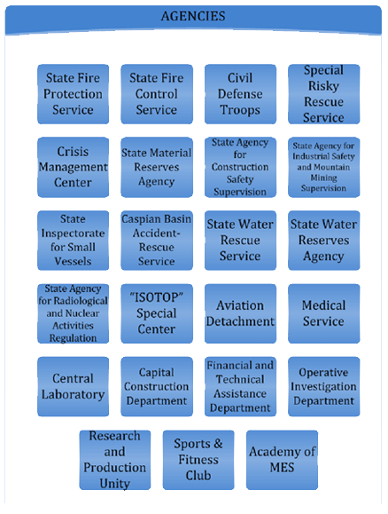
Main activities of the Ministry of Emergency Situations (MES) are as follows.
■ Protection of population and territories from fires and disasters.
■ Prevention of emergency situations and elimination of their consequences.
■ Ensuring of safety rules of water basins, building sites, industrial and mining enterprises and safe movement of small vessels in state waters.
■ Establishment and proper management of the State Resource Fund.
■ Organization of the protection of strategic objects exposed to natural, man-made and terror threats, neutralization of radioactive wastes.
■ Organization of quick response to emergency situations and management of humanitarian aids.
■ Organization and implementation of rescue-searching and first aid, aviation and other transport life-saving operations in case of emergencies.
■ Organization of awareness-raising activities among population regarding life safety rules and measures, methodical guidance over respective work done in this field by state bodies and public organizations etc.
Country Report
Country Report 2023 (English Version, PDF file)
Country Report 2014 (English Version, PDF file)
Country Report 2011 (English Version, PDF file)
Disaster Information (The latest 10)
・2002/10/22 : Severe Local Storm
Azerbaijan, Türkiye Enhance Disaster Risk Reduction Ties
Azerbaijan and Türkiye are collaborating in disaster risk reduction and in responding to the damage caused by natural disasters, said Ali Hamza Pehlivan, head of Türkiye’s Disaster and Emergency Management Authority (AFAD).
He noted that last week, a delegation from Azerbaijan’s Ministry of Emergency Situations visited AFAD, The Caspian Post reports citing Report.
Pehlivan emphasized that the collaboration between Azerbaijan’s Ministry of Emergency Situations and AFAD includes mutual visits, experience sharing, and joint exercises.
Download documents on Azarbijan Multi-Hazards at
https://drive.google.com/drive/folders/1OsKHXCB7_XLrQNRfKG7Jp5f4eZJNna-L?usp=drive_link
Subject: Looking forward to the scope of work and partnership opportunity with the Ministry of Emergency Situations of the Republic of Azerbaijan https://fhn.gov.az/en
To,
Ministry of Emergency Situations of the Republic of Azerbaijan
Dear Sir,
Greetings from the Multi-Hazard Early Warning System Design and Implementation Center (MHEWC).
MHEWC provides technical solutions to strengthen Disaster Risk Management (DRM) governance systems, climate and multi-hazard risk management, and end-to-end early warning system design and implementation. We would be pleased to offer technical support to the Ministry of Emergency Situations , in the following areas:
a) Upgrading existing web portal into a geospatial, database-driven, and app-enabled Decision Support System (DSS) to support real-time disaster risk governance, planning, preparedness, response, and recovery management.
b) Conducting climate and multi-hazard risk and vulnerability assessments, including the preparation of geospatial hazard, exposure, vulnerability, and risk maps, and the establishment of a centralized risk information repository and database management system.
c) Assessing existing monitoring, observation, and early warning capacities and supporting the Ministry of Emergency Situations in the installation, enhancement, and integration of observation networks, including Automated Weather Stations (AWS), hybrid weather and hazard monitoring systems, and sensor-ingested real-time data systems linked to a functional DSS.
d) Designing and operationalizing end-to-end multi-hazard early warning systems, including weather and hazard nowcasting services, impact-based forecasting, forecast-based anticipatory early action, forecast-based emergency preparedness and response management, forecast-based financing, Early Action Protocol development, and DSS-supported Standing Orders on Disaster and Standard Operating Procedures.
e) Supporting automated hazard detection, monitoring, prediction, and emergency operations management, including the design, implementation, and operationalization of a Multi-Hazard and Disaster Emergency Operations Center (EOC).
f) Developing GIS, database, and information tool-driven local government and productive sector-level risk-informed planning and budgeting systems to strengthen disaster risk reduction, climate change adaptation, nature-based solutions, locally led adaptation, and resilience planning.
g) Reviewing and upgrading multi-hazard preparedness, response, and recovery plans across administrative levels and relevant priority sectors, in alignment with the Ministry of Emergency Situations’ institutional mandate and national disaster management priorities.
h) Providing any additional technical assistance as may be required by the Ministry of Emergency Situations to strengthen national-to-last-mile disaster risk governance and early warning capacities.
We would welcome the opportunity to discuss the Ministry of Emergency Situations’ priorities and explore how MHEWC can support the development of a practical implementation roadmap for strengthening multi-hazard early warning, risk information, and disaster risk governance systems.
We look forward to your kind response.
Sincerely,
Z M Sajjadul Islam
Director
Multi-Hazard Early Warning System Design and Implementation Center (MHEWC)
Web: mhewc.org
Email: [ sajjad@mhewc.org ] [ zmsajjad@gmail.com ]
Phone & WhatsApp: +88 01711 979179