Costa Rica Climate Risk and Vulnerabilities
Riesgos climáticos y vulnerabilidades de Costa Rica
Costa Rica is exposed to a complex climate and multi-hazard risk environment, including earthquakes, volcanic activity, floods, landslides, tropical storms, hurricane-related extreme rainfall, droughts, coastal erosion, and sea-level rise. Its location in a seismically active zone, combined with mountainous terrain, intense rainfall, riverine systems, coastal settlements, and climate-sensitive economic sectors, increases the country’s vulnerability to both sudden-onset and slow-onset hazards. Climate change is expected to further intensify these risks through rising temperatures, changing rainfall patterns, drought stress, extreme precipitation, ecosystem degradation, and increasing pressure on water resources, agriculture, infrastructure, tourism, and vulnerable communities. Although Costa Rica has relatively strong disaster risk management and adaptation institutions, persistent vulnerabilities remain in informal settlements, rural livelihoods, transport networks, coastal zones, critical infrastructure, and populations living in flood-, landslide-, volcanic-, and earthquake-prone areas.
Costa Rica is exposed to a complex climate and multi-hazard risk profile shaped by its tectonic location, mountainous terrain, tropical rainfall patterns, river systems, coastal zones, and dependence on climate-sensitive sectors. The country faces risks from earthquakes, volcanic activity, floods, landslides, tropical storms, hurricane-related rainfall, drought, coastal erosion, sea-level rise, and ecosystem degradation. GFDRR identifies Costa Rica as one of the more earthquake-prone and volcanically active countries, while also noting its exposure to floods, hurricanes, earthquakes, and landslides. (gfdrr.org)
1. Multi-hazard exposure
Costa Rica’s hazard profile includes both geophysical hazards and hydrometeorological hazards. Its location near the interaction of the Cocos and Caribbean tectonic plates creates high exposure to earthquakes and volcanic hazards. At the same time, intense rainfall, steep slopes, and riverine systems increase the probability of floods and landslides, especially during tropical storms and extreme rainfall events. (gfdrr.org)
Earthquake risk is particularly significant. A World Bank/GFDRR disaster risk profile estimates Costa Rica’s annual average loss from earthquakes at around US$407.5 million, equivalent to approximately 0.82% of GDP, and notes that earthquake risk is more significant than hurricane risk in the country. (gfdrr.org)
2. Climate change as a risk multiplier
Climate change is expected to intensify Costa Rica’s existing vulnerabilities by increasing temperatures, altering rainfall patterns, increasing drought stress in some regions, and contributing to more severe flood and landslide risks during extreme rainfall events. The World Bank Climate Change Knowledge Portal identifies Costa Rica’s exposure to climate-related hazards including droughts, floods, landslides, and earthquakes, while highlighting the importance of adaptation for climate-sensitive sectors. (Climate Change Knowledge Portal)
Costa Rica’s National Adaptation Plan 2022–2026 recognizes climate change as a major threat to social, economic, and environmental resilience. The plan focuses on strengthening decision-making, integrating adaptation into planning and finance, adapting public services, protecting productive systems and infrastructure, and implementing nature-based solutions. (Dirección de Cambio Climático)
3. Key vulnerabilities
Flood and landslide vulnerability is high in areas with steep terrain, unstable slopes, degraded land, poorly planned settlements, and riverine exposure. UNDP notes that Costa Rica’s vulnerability to extreme climate events is partly linked to populations living in areas prone to volcanic eruptions, unstable lands, degraded landscapes, and settlements exposed to landslides and flooding. (Adaptation UNDP)
Agriculture and rural livelihoods are climate-sensitive because crop production, livestock systems, water availability, and rural infrastructure depend heavily on rainfall patterns and stable ecosystems. UNDP notes that agriculture accounts for around 36% of land use and about 14% of employment in Costa Rica, making droughts, floods, pests, rainfall variability, and soil degradation important livelihood risks. (Adaptation UNDP)
Water resources are vulnerable to both drought and extreme rainfall. Drought can reduce water availability for households, agriculture, ecosystems, and hydropower, while intense rainfall can damage water infrastructure, increase sedimentation, contaminate supplies, and trigger floods and landslides. Costa Rica’s adaptation agenda identifies water resources as one of the priority sectors affected by climate change. (NAP Global Network)
Coastal zones and tourism areas are exposed to sea-level rise, coastal erosion, storm surge, saltwater intrusion, flooding, and ecosystem degradation. These risks are important because coastal tourism, beaches, wetlands, biodiversity, and marine ecosystems are central to Costa Rica’s economy and environmental identity. The NAP-related platform highlights climate impacts across priority sectors including biodiversity, water resources, health, agriculture and fisheries, infrastructure, urban development, and tourism. (NAP Global Network)
Infrastructure vulnerability is significant because roads, bridges, schools, hospitals, drainage systems, water networks, and public buildings are exposed to earthquakes, floods, landslides, and extreme rainfall. This is especially critical in mountainous areas, river basins, informal settlements, and transport corridors where slope failure or flooding can isolate communities and disrupt services.
Social vulnerability is concentrated among poorer households, informal settlements, migrants, rural communities, smallholder farmers, women-headed households, Indigenous peoples, and communities living on unstable slopes, riverbanks, or flood-prone areas. These groups often have higher exposure, weaker housing conditions, lower savings, limited insurance coverage, and reduced capacity to recover after disasters.
4. Sector-specific climate risks
Costa Rica’s main climate-sensitive sectors include:
| Sector | Main risks |
|---|---|
| Agriculture and livestock | Drought, floods, pests, diseases, rainfall variability, heat stress, soil erosion |
| Water resources | Water scarcity, sedimentation, contamination, drought stress, damaged infrastructure |
| Transport infrastructure | Landslides, road washouts, bridge damage, slope instability, flood disruption |
| Urban settlements | Flooding, drainage failure, landslides, heat stress, informal settlement exposure |
| Coastal tourism | Coastal erosion, beach loss, sea-level rise, storm surge, ecosystem degradation |
| Biodiversity and ecosystems | Habitat loss, climate stress, forest degradation, coastal ecosystem damage |
| Public health | Heat stress, waterborne diseases, vector-borne disease risks, disaster-related service disruption |
5. Priority resilience needs
Costa Rica’s resilience agenda should prioritize multi-hazard early warning systems, seismic-resilient infrastructure, flood and landslide risk mapping, risk-informed land-use planning, climate-resilient agriculture, watershed management, coastal protection, ecosystem-based adaptation, resilient transport networks, and disaster risk financing. These measures are particularly important for protecting vulnerable communities, reducing infrastructure losses, safeguarding water and food security, and preserving Costa Rica’s long-term development gains.
- Multi-Hazard Probabilistic Model: A national-scale multi-hazard assessment by the National Commission for Emergencies (CNE) and UNDRR maps direct physical losses and infrastructure risks.
- National System of Territorial Information (SNIT): The Costa Rican government provides interactive, publicly accessible hazard mapping—including flood and landslide zones—through the official SNIT Geo-Portal.
- Global Facility for Disaster Reduction and Recovery (GFDRR): Detailed synthesis of the country’s multi-hazard exposure and climate adaptation strategies is available in the GFDRR Country Notes Costa Rica.
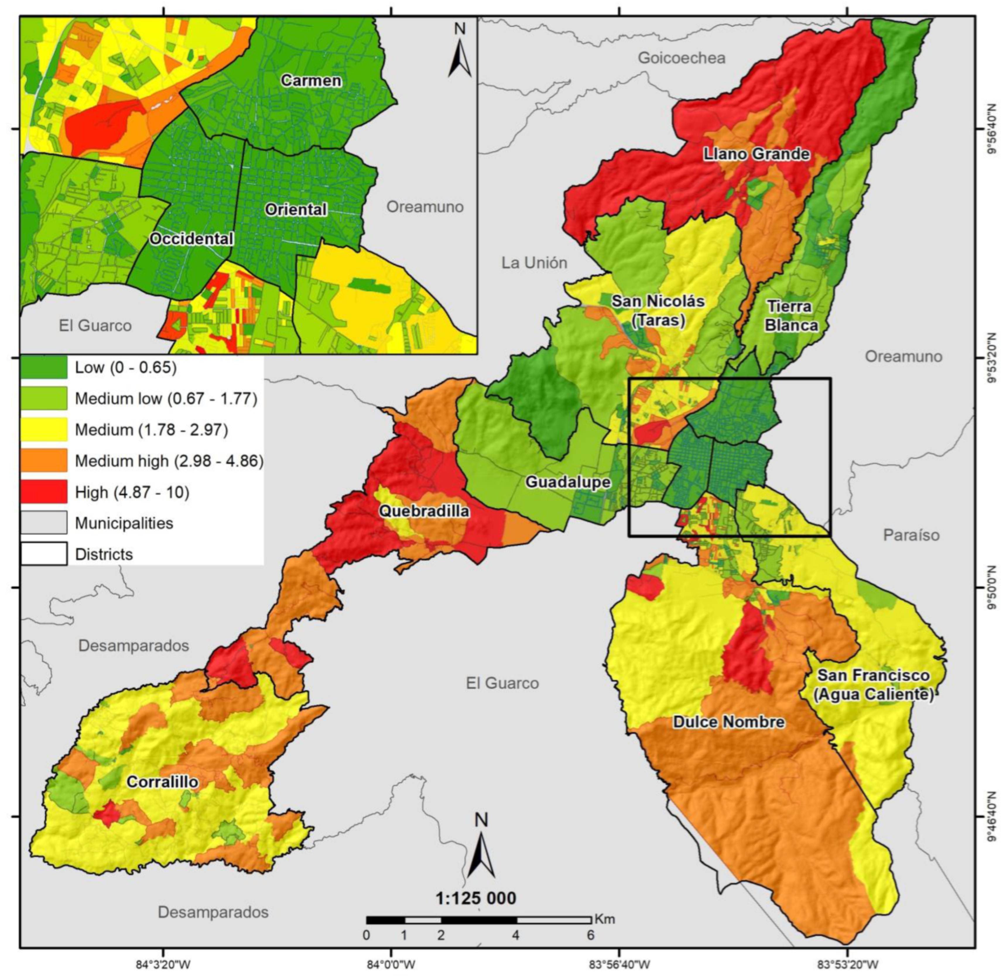
- Landslides: Mountainous regions, particularly along the Central Volcanic Range and the Talamanca Mountains, carry very high landslide risks, especially during heavy rainfall.
- Flooding: The Northern Caribbean plains (e.g., Tortuguero/Limón) and the Pacific coast (e.g., Parrita, Golfito, and the Térraba river basin) are highly susceptible to river flooding and sea-level rise.
- Seismic & Volcanic Activity: The Central Valley (including the San José metropolitan area) is located in a high-risk zone for seismic activity and volcanic ash fall from active volcanoes like Turrialba and Poás.
Costa Rica is exposed to a complex multi-hazard risk environment shaped by its tectonic setting, mountainous terrain, tropical rainfall patterns, river systems, and coastal geography. The country faces significant risks from earthquakes, volcanic activity, floods, landslides, tropical storms, hurricane-related rainfall, droughts, coastal erosion, and sea-level rise. Climate change is expected to intensify these risks by increasing temperatures, altering rainfall patterns, increasing the likelihood of extreme rainfall and drought stress, and placing additional pressure on water resources, agriculture, ecosystems, infrastructure, and vulnerable communities. Although Costa Rica has relatively strong disaster risk management and climate governance systems, persistent vulnerabilities remain in informal settlements, rural livelihoods, critical infrastructure, transport networks, coastal zones, and climate-sensitive sectors such as agriculture and tourism. Strengthening multi-hazard early warning systems, resilient infrastructure, risk-informed land-use planning, ecosystem-based adaptation, disaster risk financing, and locally led resilience measures is essential to reduce future losses and protect development gains.

Extended country-risk framing: Costa Rica climate and multi-hazard risk
1. Multi-hazard exposure
Costa Rica faces both geological and climate-related hazards. The geological risk is significant because the country lies in a tectonically active zone associated with the Cocos and Caribbean plates. This creates high exposure to earthquakes and volcanic hazards. GFDRR notes that Costa Rica has experienced floods, hurricanes, earthquakes, and landslides, and identifies the country as one of the world’s more earthquake-prone and volcanically active countries. (GFDRR)
Hydrometeorological hazards are equally important. Heavy rainfall, tropical storms, hurricanes passing through or near Central America, and localized convective storms generate recurrent flooding and landslides. Even when hurricanes do not make direct landfall, their outer bands and associated rainfall can trigger riverine flooding, flash floods, slope failures, road damage, and disruption of public services.
2. Earthquake and volcanic risk
Earthquake risk is one of Costa Rica’s most important disaster-risk drivers. A World Bank/GFDRR risk profile estimates that earthquake risk is more significant than hurricane risk in Costa Rica, with annual average loss from earthquakes estimated at about US$407.5 million, equivalent to around 0.82% of GDP. (GFDRR)
This means that seismic risk is not only a life-safety concern; it is also a major fiscal, infrastructure, and development risk. Critical assets such as schools, hospitals, roads, bridges, water systems, public buildings, housing, and energy infrastructure require seismic-resilient planning, retrofitting, enforcement of building codes, and continuity planning.
Volcanic risk also matters because several volcanoes are active or potentially hazardous. Volcanic ash, lahars, gas emissions, and related slope instability can affect settlements, agriculture, tourism, roads, water systems, and air transport. The highest concern is where volcanic exposure overlaps with settlements, tourism zones, productive landscapes, and transport corridors.
3. Flood and landslide vulnerability
Floods and landslides are among the most recurrent hazards in Costa Rica. The country’s steep terrain, short and fast-draining river basins, intense rainfall, deforestation or land degradation in some areas, and settlement expansion in unstable slopes or floodplains create high localized risk.
Costa Rica’s vulnerability to extreme climate events is partly linked to populations living in areas exposed to volcanic eruptions, unstable lands, degraded areas, and poorly planned settlements prone to landslides and flooding. UNDP also notes that agriculture accounts for around 36% of land use and about 14% of employment, making climate shocks directly relevant to livelihoods and rural economies. (UNDP Adaptation)
Flood and landslide risk is especially important for:
Roads and bridges: Mountain roads, river crossings, and rural access routes are highly vulnerable to rainfall-triggered landslides and washouts.
Urban settlements: Informal or poorly planned settlements on steep slopes and riverbanks face repeated flood and slope-failure risks.
Water systems: Heavy rainfall can damage intakes, pipelines, treatment systems, and drainage infrastructure.
Agriculture: Excess rainfall can damage crops, soil, irrigation systems, storage, and rural roads.
Tourism: Access roads, coastal areas, protected areas, and mountain destinations can be disrupted by extreme weather.
4. Hurricane and tropical-storm impacts
Costa Rica is not among the countries most frequently hit by direct hurricane landfall, but it is still exposed to hurricane-related rainfall, tropical storms, and regional storm systems. Recent events such as Hurricane Eta in 2020, extreme rainfall in July 2021, and Tropical Storm Bonnie in 2022 caused severe damages across public facilities, water resources, transport, and other sectors in 37 of Costa Rica’s 82 cantons, according to the World Bank. (World Bank)
This is an important distinction: Costa Rica’s hurricane risk is often less about direct wind impact and more about extreme rainfall, flooding, landslides, river overflow, transport disruption, and damage to public infrastructure.
5. Climate change as a risk multiplier
Climate change acts as a risk multiplier for Costa Rica’s existing hazard profile. Rising temperatures, rainfall variability, more intense precipitation, drought stress, and sea-level rise can intensify existing vulnerabilities. The World Bank Climate Change Knowledge Portal identifies adaptation priorities for Costa Rica, particularly in water supply and agriculture, while noting the country’s exposure to climate-related vulnerabilities and disaster risks. (Climate Change Knowledge Portal)
The expected climate-risk pattern is spatially differentiated:
The Caribbean side may face higher flood risk from intense and prolonged rainfall.
The Pacific and northern regions may experience stronger drought stress and water scarcity.
The Central Valley and urbanized areas face combined risks from flooding, landslides, heat, drainage stress, and exposed infrastructure.
The coastal zones face sea-level rise, coastal erosion, storm surge, salinity intrusion, and ecosystem degradation.
6. Water, agriculture, and food-system vulnerability
Costa Rica’s water security is sensitive to rainfall variability, drought, watershed degradation, and extreme rainfall events. Too little rainfall creates water scarcity, agricultural stress, hydropower concerns, and ecosystem stress. Too much rainfall generates floods, landslides, sedimentation, contamination, and infrastructure damage.
Agriculture is particularly exposed because production depends on rainfall, temperature, soil moisture, slope stability, water availability, and rural transport access. Climate-sensitive crops, livestock systems, and small producers are vulnerable to droughts, floods, pests, diseases, and market disruptions following disasters.
Key agricultural vulnerabilities include:
Drought stress in water-limited regions.
Flood damage to crops, rural roads, irrigation, and drainage systems.
Landslide impacts in mountainous agricultural areas.
Pest and disease shifts linked to temperature and humidity changes.
Livelihood insecurity among smallholders and rural workers.
7. Coastal and ecosystem vulnerability
Costa Rica’s coastal areas are exposed to sea-level rise, storm surge, coastal erosion, saltwater intrusion, and damage to coastal infrastructure. Coastal ecosystems such as mangroves, wetlands, beaches, coral systems, and marine habitats provide natural protection but are also vulnerable to warming, erosion, pollution, land-use pressure, and extreme events.
This matters because Costa Rica’s economy and identity are strongly linked to biodiversity, protected areas, ecosystem services, and nature-based tourism. Damage to ecosystems is therefore not only an environmental issue; it is also a livelihood, tourism, water-security, and disaster-risk issue.
8. Urban and infrastructure vulnerability
Costa Rica’s disaster risk is strongly concentrated in infrastructure systems. Roads, bridges, drainage, schools, hospitals, water systems, public buildings, and emergency shelters are exposed to floods, landslides, earthquakes, and extreme rainfall.
The World Bank’s 2024 Climate Resilient Recovery and Territorial Development Project is designed to strengthen disaster- and climate-resilient infrastructure and services, including flood control, slope stabilization, reconstruction of bridges and roads, emergency shelters, and disaster response facilities. The project is expected to benefit around 2 million people, nearly 40% of the country’s population. (World Bank)
This confirms that Costa Rica’s risk-management challenge is not only forecasting hazards; it is also about reducing the physical vulnerability of public infrastructure and territorial development systems.
9. Social vulnerability and territorial inequality
Costa Rica has relatively strong institutions compared with many countries in the region, but social vulnerability remains uneven. Poor households, migrants, informal settlers, rural communities, small farmers, women-headed households, Indigenous communities, people living on unstable slopes or riverbanks, and communities dependent on climate-sensitive livelihoods often face greater exposure and lower recovery capacity.
Hazard exposure overlaps with:
- Poor-quality housing.
- Informal or unplanned settlements.
- Limited drainage and slope protection.
- Weak road access.
- Dependence on agriculture, tourism, or informal income.
- Limited insurance or savings.
- Limited access to early warning and emergency services.
10. Risk governance implications
Costa Rica has made important progress in disaster risk management, climate policy, conservation, and adaptation planning. However, the country still needs sustained investment in risk-informed land-use planning, resilient infrastructure, climate-smart agriculture, watershed management, early warning systems, disaster risk financing, and nature-based solutions.
Priority actions should include:
- Strengthening multi-hazard early warning systems for floods, landslides, extreme rainfall, drought, volcanic activity, and seismic risk.
- Integrating risk information into land-use planning, zoning, building permits, and public investment decisions.
- Retrofitting critical infrastructure, especially schools, hospitals, bridges, water systems, and emergency shelters.
- Improving slope stabilization and drainage systems in high-risk urban and rural areas.
- Expanding climate-resilient agriculture, drought management, water harvesting, soil conservation, and crop-risk advisory services.
- Using ecosystem-based adaptation, including mangrove restoration, watershed protection, reforestation, and river-basin management.
- Strengthening disaster risk financing, including contingent credit, insurance, budget instruments, and shock-responsive social protection.
- Targeting vulnerable groups, particularly informal settlements, rural producers, migrants, women, Indigenous communities, and communities in floodplain or landslide-prone areas.
Costa Rica Climate Change Web Portal
River floodHazard level: High
In the area you have selected (Costa Rica) river flood hazard is classified as high based on modeled flood information currently available to this tool. This means that potentially damaging and life-threatening river floods are expected to occur at least once in the next 10 years. Project planning decisions, project design, and construction methods must take into account the level of river flood hazard. Surface flood hazard in urban and rural areas is not included in this hazard classification, and may also be possible in this location. Please see ‘Urban Flood’ for consideration of urban surface and river flooding.The following is a list of recommendations that could be followed in different phases of the project to help reduce the risk to your project. Please note that these recommendations are generic and not project-specific.
Climate change impacts: Model projections are inconsistent in their estimates of changes in rainfall. The present hazard level may increase in the future due to the effects of climate change. It would be prudent to design projects in this area to be robust to river flood hazard in the long-term.
Recommendations
- LOCATION ASSESSMENT: The high-level information available in this tool may indicate the presence of river flood hazard in your project area. Before committing significant resources to this issue, a study of the surrounding landscape can help you assess whether more detailed assessment and/or intervention should be considered. More information
- EXISTING INFORMATION: The high-level information available in this tool may indicate the presence of flood hazard in your project area. However, because flood hazard can change dramatically over short distances, the exact geographical location of your project should be checked against pre-existing flood hazard information. More information
- TECHNICAL EXPERTISE: Consultation with flood risk experts will provide a more detailed understanding of the risk posed to your asset by flooding. The level of guidance required will depend upon the level of hazard present, the vulnerability of the asset and local legislation that might apply. More information
- PROJECT LOCATION: Consider relocation of the project. If local flood risk information confirms your project is exposed to a high level of flood hazard, relocation to areas not prone to flooding is recommended where viable. This decision will need to be undertaken with the consideration of other hazards. More information
- EARLY WARNING SYSTEMS: Identify early warning systems (EWS) that may exist in your project area. Receive warning messages and be aware of what happens when a warning is triggered. Ensure that the warnings will be received in the facilities built and the people working or living there. Flood early warning systems are designed to provide communities with advanced warning of an imminent flood event based on weather forecasts, rainfall and upstream water levels, and can be used to trigger deployment of portable flood defences or evacuation to mitigate impacts of a flood. More information
- INTERDEPENDENCY: Consider vulnerability of other assets within the project’s dependency network. If your project is interdependent with other projects, it is important to assess the vulnerability of the entire network if the service provided is critical. More information
- FLOOD HAZARD MANAGEMENT: Your project or development should consider flood management measures, such as restoration of natural wetlands, removal of impermeable surfaces, or implementation of flood defences at the project site and in the upstream catchment. More information
- DO NOT INCREASE HAZARD: Built infrastructure may alter flood hazard. Constructing a significant piece of infrastructure can significantly alter the landscape and potentially influence how an area responds during a flood. Any alteration of the landscape should be undertaken with consideration as to how this will influence the local hydrology. More information
Principal Regional Hazards Tracked
The mapping frameworks inside these files primarily isolate the intersection of these overlapping geographical threats:
- Hydrometeorological: Heavy seasonal rainfall, tropical storms (e.g., Nate and Eta), and coastal storm surges along its 1,300 km coastline.
- Geomorphological: Landslides and soil instability triggered by agricultural land degradation and steep slopes.
- Seismic/Volcanic: Active fault lines intersecting major population clusters, particularly in the Central Valley. [5, 6, 9, 11, 12]
If you are looking for a specific canton or region within Costa Rica (such as Cartago or Santa Ana), let me know so I can point you toward localized academic geomorphological mapping PDFs. [13, 14]
[1] https://www.globalshield.org
[2] https://www.preventionweb.net
[4] https://www.researchgate.net
[5] https://documents1.worldbank.org
[6] https://www.kerwa.ucr.ac.cr
[7] https://www.globalshield.org
[10] https://www.mdpi.com
[11] https://www.researchgate.net
[12] https://www.adaptation-undp.org
[13] https://www.researchgate.net
[14] https://www.researchgate.net
Please download detailed information on Costa Rica
https://drive.google.com/drive/folders/18qe7gTtYFNrVI4MVMQOUeJF0I5sBtgx1?usp=sharing