MHEWC Offers Technical Support to the Mauritania Crisis Monitoring and Management Centre (Centre Opérationnel de Veille, d’Alerte et de Conduite des Crises, or COVACC) to Modernize and Automate Multi-Hazard Early Warning Systems, Emergency Operations Centers (EOCs), and an Integrated Risk Intelligence Command and Control System.
To,
Colonel Dahi Ould El Mamy (Director General of Civil Protection) & Mauritania Crisis Monitoring and Management Centre (Centre Opérationnel de Veille, d’Alerte et de Conduite des Crises, or COVACC)
Subject: Proposal for Technical Cooperation and Partnership to Strengthen Multi-Hazard Early Warning Systems, Disaster Risk Governance, and Emergency Management Capacities
Dear Sir,
Greetings from the Multi-Hazard Early Warning System Development and Implementation Center (MHEWC).
MHEWC is a specialized technical knowledge and solutions platform dedicated to strengthening climate and multi-hazard risk governance, disaster risk management, and integrated, end-to-end, people-centered early warning systems. Our expertise encompasses institutional capacity assessments, hydro-meteorological observation and monitoring networks, geospatial risk intelligence, ICT- and AI-enabled Decision Support Systems (DSS), impact-based forecasting, anticipatory action, and disaster preparedness, response, and recovery.
Effective disaster risk governance requires policy commitments to be translated into functioning systems and reliable services. International technical assistance and national investments should therefore connect policy development and institutional capacity building with practical system design, software development, data integration, deployment, maintenance, and operational use. This requires multidisciplinary technical expertise, including the appropriate application of machine learning and AI, to support timely, risk-informed decisions and actionable warnings for communities.
MHEWC is developing a hybrid ICT-based system designed to integrate real-time monitoring of hazardous weather and emerging threats, hazard detection and tracking, and landscape-level exposure and vulnerability information. The system aims to provide Emergency Operations Centers (EOCs) with actionable risk intelligence and support the automated dissemination of authorized warnings through the Common Alerting Protocol (CAP) to local authorities, frontline responders, and at-risk communities.
Recognizing the importance of strengthening national disaster risk management capabilities, MHEWC would welcome the opportunity to establish technical cooperation and a strategic working partnership with COVACC. Through this partnership, we propose to support comprehensive technical and institutional assessments, system development and deployment, and targeted capacity building, helping translate investments into operational systems, trained personnel, tested procedures, and effective warning and response services.
MHEWC can provide an integrated package of technical support, from project concept and funding proposal development to system deployment and operationalization. This includes preparing proposals for potential financing from most international donors, including the Green Climate Fund (GCF), the European Union (EU), the World Bank, AfDB, and other international financing partners. Proposals would be aligned with the National Adaptation Plan (NAP), Nationally Determined Contribution (NDC), and relevant local adaptation and mitigation priorities, while exploring complementary technical support through initiatives such as UNDP’s Climate Promise.
MHEWC offers an integrated, end-to-end package of technical assistance, covering project conceptualization, feasibility assessments, funding proposal development, resource mobilization, technical system design, deployment, institutional capacity development, and full operationalization of ICT-driven climate-risk intelligence, disaster risk management, and multi-hazard early warning systems (MHEWS).
MHEWC support for developing all project concepts, funding proposals, and investment frameworks would align with national development and climate-policy priorities, particularly National Adaptation Plans (NAPs), Nationally Determined Contributions (NDCs), national and subnational disaster risk reduction strategies, and relevant sectoral investment plans. Priority areas include climate change adaptation and mitigation, nature-based solutions (NbS), locally led adaptation (LLA), climate-resilient infrastructure, impact-based forecasting (IBF), anticipatory action (AA), and measures to avert, minimize, and address climate-related loss and damage.
MHEWC would also facilitate strategic partnerships, institutional coordination, and complementary technical assistance through relevant international initiatives, including UNDP’s Climate Promise, to strengthen country ownership, enhance financing readiness, mobilize investments, and translate national climate and disaster risk management priorities into sustainable, operational programmes.
MHEWC’s technical assistance can also encompass the comprehensive design, development, deployment, integration, and operationalization of a National Emergency Operations Centre (EOC) system, interconnected with relevant national and subnational institutions, sectoral agencies, local authorities, and frontline emergency responders. This support would include establishing an integrated, nationwide, ICT-driven multi-hazard risk intelligence, early warning, and emergency coordination network, enabling real-time data acquisition, automated monitoring, forecasting, risk analysis, impact-based forecasting (IBF), anticipatory action (AA), and coordinated emergency preparedness and response. The system would integrate hydrometeorological observations, satellite and IoT sensor data, hazard forecasts, geospatial risk information, exposure and vulnerability assessments, and field-level situation reports into a centralized, interoperable Decision Support System (DSS), supporting timely, evidence-based decisions and actionable early warnings at national, subnational, and community levels.
This integrated approach would strengthen disaster risk governance, institutional interoperability, operational coordination, and risk-informed decision-making across climate-vulnerable productive sectors, critical infrastructure, and essential public services. It would contribute to safeguarding lives and livelihoods, protecting development investments, reducing disaster-related losses and damage, and enhancing food, water, health, and energy security, while advancing climate resilience, sustainable economic development, and long-term national disaster preparedness and response capabilities.
Our support can also cover designing, deploying, and operationalizing a national EOC system connected to relevant sectoral institutions, local authorities, and frontline responders. A nationwide risk intelligence network would bring together observation data, forecasts, exposure and vulnerability information, and field reports to support coordinated decisions and early action. This approach would strengthen disaster risk governance across climate-vulnerable productive sectors and essential services, contributing to food, water, health, and energy security, human safety, and climate-resilient economic development.
In collaboration with COVACC, relevant national hydro-meteorological institutions, sectoral ministries, local authorities, and other stakeholders, MHEWC is prepared to provide specialized technical assistance in the following priority areas:
1) Assessment and Modernization of Hydro-Meteorological Observation and Monitoring Networks
Conduct comprehensive technical diagnostics of existing hydro-meteorological observation stations and monitoring infrastructure, identify institutional and technological gaps, and develop a phased modernization and investment plan. This may include the technical design, installation, calibration, and integration of Automated Weather Stations (AWS), Internet of Things (IoT) sensors, and real-time environmental and hazard-monitoring technologies to strengthen the detection, tracking, and forecasting of potentially hazardous conditions.
2) Strengthening Integrated Multi-Hazard Monitoring and Early Warning Capacities
Assess existing monitoring, observation, forecasting, and early warning capabilities and support COVACC and relevant national meteorological and hydrological services in upgrading and integrating observation networks. This includes hybrid weather and hazard-monitoring systems, interoperable sensor networks, real-time data acquisition and transmission, and automated data ingestion into operational Decision Support Systems for multi-hazard monitoring, forecasting, and warning dissemination.
3) Modernization and Operationalization of the National Emergency Operations Center (EOC)
Undertake a comprehensive technical and institutional assessment of existing Emergency Operations Center facilities, operational procedures, communication systems, and information management infrastructure. Based on the findings, develop an EOC modernization roadmap and support the technical design, upgrading, and operationalization of an integrated National Emergency Operations Center and Situation Room.
The proposed EOC architecture would incorporate real-time hydro-meteorological observations, IoT-enabled monitoring networks, geospatial risk information, automated hazard tracking, impact-based forecasting, early warning dissemination, anticipatory action advisories, and coordinated emergency response management.
4) Development of ICT- and AI-Enabled Emergency Management and Decision Support Applications
Design and develop customized ICT- and AI-enabled applications to support automated hazard identification, real-time monitoring, predictive analytics, impact forecasting, emergency information management, and operational decision-making.
These solutions may include automated data processing, geospatial visualization, scenario-based impact analysis, threshold-based alert generation, emergency resource tracking, incident management, and decision-support workflows. AI-assisted outputs would be subject to appropriate technical validation and oversight by authorized national institutions.
5) Transformation of COVACC’s Web Portal into an Integrated Geospatial Decision Support Platform
Provide technical assistance to assess and upgrade COVACC’s existing web-based information systems into an integrated, geospatial, database-driven, and application-enabled Disaster Risk Information and Decision Support System (DRI-DSS).
We are currently developing a country-level Multi-hazard Risk Intelligence and DSS Command and Control Center that would be suitable for the Risk Intelligence Governance System. Please visit https://ccr.mhewc.org/
The platform would support real-time hazard monitoring, climate and multi-hazard risk information management, institutional coordination, preparedness planning, anticipatory action, emergency response, recovery management, and evidence-based decision-making across national and subnational administrative levels.
6) Development of National Climate and Multi-Hazard Risk Assessment Frameworks and Risk Information Repositories
Develop standardized methodologies, analytical frameworks, technical tools, and operational guidelines for conducting climate and multi-hazard risk and vulnerability assessments.
Technical assistance would include the preparation of GIS-based hazard, exposure, vulnerability, and risk maps; multi-sectoral risk profiles; climate and disaster risk scenarios; and the establishment of a centralized, interoperable national risk information repository and geospatial database management system.
7) Design and Operationalization of End-to-End, People-Centered Multi-Hazard Early Warning Systems
Support COVACC and relevant technical institutions in designing and implementing integrated, end-to-end Multi-Hazard Early Warning Systems (MHEWS), aligned with the four pillars of the Early Warnings for All (EW4All) initiative.
Priority interventions may include:
- Hazard detection, monitoring, weather nowcasting, and forecasting services.
- Impact-Based Forecasting (IBF) and Impact-Based Warning (IBW) systems.
- Forecast-Based Financing (FbF) and anticipatory action mechanisms.
- Development of hazard-specific triggers, Early Action Protocols (EAPs), and anticipatory response plans.
- Common Alerting Protocol (CAP)-enabled warning generation and dissemination.
- DSS-supported emergency preparedness, contingency planning, and response management.
- Development of operational guidelines, Standing Orders on Disaster, and institutional Standard Operating Procedures (SOPs).
- Strengthening last-mile warning communication, community preparedness, and coordinated early action.\
8) Integration of Climate and Disaster Risk Intelligence into Sectoral and Local Development Planning
Develop GIS-enabled databases, digital planning tools, and sector-specific risk information systems to support national ministries, government departments, municipalities, and local authorities in integrating climate and disaster risk considerations into development planning, public investment, and budgeting processes.
Technical assistance would focus on strengthening Disaster Risk Reduction (DRR), Climate Change Adaptation (CCA), Nature-Based Solutions (NbS), Locally Led Adaptation (LLA), resilient infrastructure planning, and climate-informed sectoral investment strategies.
9) Review and Strengthening of Multi-Hazard Preparedness, Emergency Response, and Recovery Plans
Review existing disaster preparedness, emergency response, contingency, and recovery plans at national, regional, municipal, and sectoral levels.
Support the development and upgrading of hazard-specific and multi-hazard operational plans, institutional coordination mechanisms, emergency communication protocols, resource mobilization procedures, and risk-informed recovery strategies consistent with COVACC’s mandate and national disaster management priorities.
10) Strengthening National-to-Local Disaster Risk Governance and Institutional Capacities
Provide specialized technical assistance to strengthen the institutional, regulatory, organizational, and operational foundations of disaster risk governance.
This may include institutional assessments, capacity development, stakeholder coordination frameworks, interagency information-sharing protocols, technical training, knowledge transfer, and the preparation of phased, costed implementation roadmaps to improve national and local emergency management capabilities.
11) Technical Support to Climate Change, Meteorological, Hydrological, and Disaster Management Institutions
Provide targeted technical support to COVACC, relevant climate change institutions, National Meteorological and Hydrological Services (NMHS), and other designated government agencies to strengthen climate information services, weather and climate monitoring, multi-hazard risk assessments, forecasting, early warning operations, climate resilience planning, and institutional technical capacities.
Such cooperation would be tailored to institutional requirements, existing technical infrastructure, priority hazards, and national development objectives.
Proposed Way Forward
MHEWC proposes initiating the cooperation through a joint technical consultation with COVACC to identify priority institutional and technological needs, review existing capacities, and determine potential areas for collaboration.
Based on COVACC’s priorities, we would welcome the opportunity to conduct an initial technical scoping and institutional capacity assessment, followed by preparing a practical, phased, costed technical cooperation and implementation roadmap.
Our approach emphasizes a one-stop services modality, least-cost and optimized technical solutions with national ownership, technology transfer, institutional sustainability, interoperability, and the development of operational systems that connect hazard observation and risk intelligence with timely warnings, informed decisions, and effective anticipatory action.
We would be pleased to arrange a virtual meeting with your technical and management teams at a mutually convenient time to discuss potential collaboration and identify immediate opportunities for technical support.
We look forward to your favorable consideration and the opportunity to contribute to strengthening national disaster risk governance, multi-hazard early warning, and emergency management systems.
Yours sincerely,
Z M Sajjadul Islam
Director & Advisor
Multi-Hazard Early Warning System Development and Implementation Center (MHEWC)
Website: https://www.mhewc.org/congo-the-democratic-republic/ http://www.glocs.org
Email: zmsajjad@gmail.com | sajjad@mhewc.org
Phone & WhatsApp: +88 01711 979179
———————————————————————————————————–
Mauritania – Climate, Multi-Hazard Risk, Vulnerability and Disaster Profile
Country profile | 22 November 2026 @Z M Sajjadul Islam
Risk overview
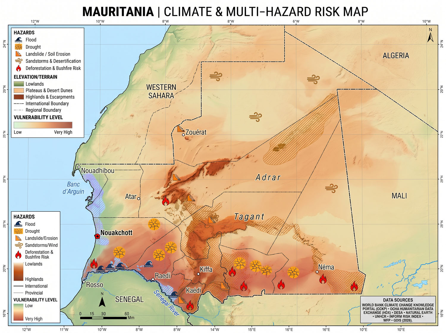
Drought, extreme heat and water scarcity are Mauritania’s most widespread climate stresses. Flooding is the most acute recurring threat to settlements and infrastructure. Along the Senegal River, floods can inundate villages, irrigation schemes and access roads after rainfall elsewhere in the basin. In Nouakchott, intense local rain can collect in low-lying districts where groundwater is shallow and drainage is limited. Atlantic waves, high tides and breaches in the coastal dune belt create an additional route for inundation. documents1.worldbank.org
Mauritania’s 2023 census counted 4.93 million residents, including 1.45 million in Nouakchott, about 29% of the national population. The World Bank estimates a national population of approximately 5.5 million in 2026. The INFORM Mid-2026 Risk Index places Mauritania at 5.3 out of 10, in the medium category, with higher scores for vulnerability, 6.0, and lack of coping capacity, 6.5. These national scores sit alongside concentrated local exposure in the capital, the Senegal River valley and the pastoral southeast. mauritania.unfpa.org
1. Climate baseline and projected change
Mauritania spans the Sahara, a Sahelian transition zone, the Senegal River floodplain, and a cooler Atlantic coastal strip. Most agricultural rainfall falls from July to September, with some rains beginning in June. The national climate submission illustrates the rainfall gradient using station averages of 37 mm per year at Bir Moghrein in the far north, 94 mm at Tidjikja in the centre, and 530 mm at Sélibaby in the far south. Outside the Atlantic coastal strip, average daily maximum temperatures in the hottest month exceed 40°C across much of the country. unfccc.int
| Climate variable | Evidence and planning implications |
|---|---|
| Observed warming and heat exposure | The World Bank reports approximately 1.5°C of warming since the 1950s and nearly 45 additional days per year with a heat index above 35°C. The heat index accounts for humidity. Rising heat exposure affects outdoor labour, livestock, water demand and electricity demand for cooling. documents1.worldbank.org |
| Future temperature | Mauritania’s NDC 3.0 reports warming of 1.9°C under SSP2-4.5 and 2.1°C under SSP3-7.0 for 2041–2060, rising to 2.9°C and 4.3°C, respectively, for 2081–2100. A separate CMIP6 assessment under SSP2-4.5 estimates 1.6°C of warming by 2050, with a reported range of 0.94–2.33°C relative to 1995–2014. unfccc.int |
| Rainfall variability and water demand | Climate models span a wide range of rainfall outcomes. For farming and grazing, the timing of onset, breaks within the rainy season and the concentration of rain in heavy events matter alongside seasonal totals. The NDC projects potential evapotranspiration 3.6% above its 2000 level by 2050, increasing pressure on soils, crops and water supplies. documents1.worldbank.org |
| Sea-level rise | The PIK/GIZ climate risk profile projects median sea-level rise off Mauritania of 19 cm by 2050 and 36 cm by 2080, relative to 2000, under RCP6.0. The national NDC reports approximately 0.5–0.6 m of rise by 2100 across the pathways it assesses. Local inundation also depends on waves, tides, ground elevation and the condition of coastal dunes. publications.pik-potsdam.de |
2. Multi-hazard risk and geographic hotspots
| Hazard | Main locations and consequences |
|---|---|
| Drought, dry spells and water scarcity | Hodh Ech Chargui, Hodh El Gharbi, Assaba, Tagant and the southern agropastoral belt depend on a short, variable rainy season. Delayed or poorly distributed rain can cause failed planting, pasture deficits and early depletion of livestock watering points. In October 2026, FAO reported that vegetation had recovered in many producing areas, while parts of Brakna, Gorgol and Hodh El Gharbi still had below-average rangeland conditions. fao.org |
| Senegal River flooding | Exposed areas extend across Guidimakha, Gorgol, Brakna and Trarza, including river reaches around Kaédi, Boghé and Rosso. Upstream rainfall, inflows from tributaries such as the Bakoye and Falémé, and reservoir operations all matter for warning. High flows can isolate villages and damage rice schemes, embankments, roads and water points. Seasonal inundation also supports flood-recession cultivation, making flood timing and depth important to agricultural decisions. OMVS |
| Urban flooding and shallow groundwater | Sebkha, El Mina and Riyad are among Nouakchott’s most flood-prone districts. A 2025 project assessment reported groundwater only 0.5–0.8 m below ground in parts of Sebkha and El Mina. Rainwater can pond in flat depressions and persist where there is little capacity for infiltration or drainage. Poor sanitation increases exposure to contaminated water. documents1.worldbank.org |
| Flash floods in towns and wadis | Dry channels and road crossings can fill rapidly after intense storms. Documented hotspots include Sélibaby in Guidimakha, Atar in Adrar, and Kankossa in Assaba. The October 2026 rains also flooded streets in F’Dérick in Tiris Zemmour and stranded travellers near Touajil. Forecasts need to identify crossings and settlements downstream of the rain. adore.ifrc.org |
| Coastal inundation, erosion and salinisation | Nouakchott’s coastal dune belt protects low-lying neighbourhoods, port approaches and industrial areas. Sand extraction has weakened parts of the belt, and coastal infrastructure can alter sediment movement. Nouadhibou Bay, Banc d’Arguin and the Ndiago–Diawling delta have different exposure profiles involving ports, fishing livelihoods, wetlands and coastal water quality. WACA |
| Extreme heat, dust storms and vegetation fires | Inland towns, pastoral routes, work sites and isolated settlements face heat and poor visibility. ONM issued northern heat warnings in July and August 2026 and dust or sandstorm warnings in October and November. In the agropastoral south, dry-season fires can remove valuable forage. Mauritania’s 2026 firebreak campaign included Kankossa. meteomauritanie.mr |
| Crop pests and public-health hazards | Desert locusts can damage crops and pasture. On 6 November 2026, FAO reported breeding and the formation of adult and hopper groups in northwestern Mauritania. Rift Valley fever is a recurring zoonotic hazard affecting people and livestock. WHO recorded outbreaks in 2022 and 2025, supporting coordination between public-health and veterinary surveillance. fao.org |
3. Vulnerability and cascading impacts
- Pastoral and agricultural livelihoods. A rainfall deficit can reduce both forage and surface water. Herds then concentrate around functioning water points or move farther, increasing costs and pressure on grazing. Monitoring should combine rainfall, pasture condition and water-point status with livestock-to-cereal terms of trade, which indicate whether pastoral households can still buy enough food. In August–September 2026, these terms of trade were unfavourable in Brakna, Gorgol and Guidimakha, even as conditions were more favourable in some eastern areas. fao.org
- Food insecurity and displacement. FAO reported that more than 500,000 Mauritanian residents faced Cadre Harmonisé Phase 3 or worse during the June–August 2026 lean season, including about 13,900 in Phase 4. A separate analysis estimated that over 112,000 Malian refugees in Hodh Ech Chargui faced Phase 3 or worse during the same period. UNHCR’s 31 October 2026 dashboard estimated 305,000 refugees and asylum seekers nationally, including 189,061 registered. In the Bassikounou–Mbera area, drought and flood planning needs to cover shared water points, health services and access routes for refugees and host communities. fao.org
- Housing, health and access to services. In Nouakchott’s low-lying districts, standing water can damage housing and interrupt access to schools, clinics and markets after rainfall has stopped. In the river valley and inland towns, damage to a bridge, road or water point can cut off several communities at once. The 2023 Boghé floods illustrate the scale of this secondary impact. An initial Red Crescent assessment recorded 42 water points and 530 latrines destroyed. wydawnictwo.pan.pl
- Economic and fiscal exposure. The World Bank estimates average annual flood losses of around 0.4% of GDP and a 1% annual probability of flood losses exceeding 4.2% of GDP. Its 2025 growth and jobs report also estimates that climate impacts could leave 2050 GDP up to 9.3% below a scenario without climate change, with losses through heat-related labour productivity, agriculture, livestock, flooding and sea-level rise. The latter is a scenario-based estimate of the level of GDP in 2050. documents1.worldbank.org
4. Selected disasters and recent impacts
| Event | Documented impacts |
|---|---|
| August 2019 – Sélibaby and Guidimakha floods | IFRC’s final report counted 33,600 people affected across Guidimakha. UNICEF reported five deaths and damage to schools, health centres and water points following severe rainfall in late August. adore.ifrc.org |
| 2020–2022 – Prolonged drought | The World Bank estimates that the drought affected up to one-third of the population. An African Risk Capacity evaluation records a US$1.72 million payment to the government in March 2022 following the 2021–2022 agricultural rainfall deficit. documents1.worldbank.org |
| 2022 rainy season – Widespread flooding | IFRC reported 28,926 people affected and 14 deaths. A broader national assessment cited by the World Bank estimated US$279 million in damage and US$306 million in recovery needs. Final Report |
| August 2023 – Boghé and Brakna floods | The initial Mauritanian Red Crescent and French Red Cross assessment reported 7,200 people affected, 1,101 displaced, one death and 330 houses destroyed. adore.ifrc.org |
| October 2024 – Senegal River flood | IFRC recorded approximately 12,500 people affected in Mauritania. OMVS described exceptional river flows and issued vigilance notices as the flood wave moved through the basin. go.ifrc.org |
| August 2025 – River flooding across four southern wilayas | As of 30 August, IFRC figures relayed by ECHO recorded 6,540 people affected, 5,700 displaced and two deaths. The worst-affected wilayas included Gorgol, Guidimakha, Brakna and Trarza. gdacs.org |
| September–October 2025 – Rift Valley fever | WHO recorded 46 confirmed human cases and 14 associated deaths in Mauritania between 27 September and 30 October. This followed the 2022 outbreak, when 47 confirmed human cases and 23 deaths were reported. who.int |
| September–October 2026 – Local flash flooding | Official reports document rain and flood damage in Atar, Kankossa and F’Dérick, including impacts on homes, public buildings and road access. The reports describe local incidents and their response. الوكالة الموريتانية للأنباء |
5. Disaster governance, early warning and finance
Decree No. 2023-142 established the national framework for emergency preparedness and response. The General Delegation for Civil Security and Crisis Management (DGSCGC) chairs the Technical Intervention Commission. The National Crisis Management Centre (CNGC) supports monitoring and operational coordination. At wilaya level, regional emergency cells support the wali, or governor, in coordinating response and preparing emergency plans. ONM provides national weather and climate services, while OMVS coordinates basin-level cooperation and publishes the Senegal River flood alert plans, including Mauritania’s plan. finances.gov.mr
| Area | Status and developments |
|---|---|
| Weather alerts and observation | ONM publishes Common Alerting Protocol (CAP) warnings through a feed listed in the WMO register. Its 2024–2030 Strategic Plan identifies sparse observation coverage and the need to strengthen both meteorological and hydrological monitoring. alertingauthority.wmo.int |
| National multi-hazard warning development | A January 2026 consultation considered a national climate intelligence and multi-hazard early-warning project anchored by the National Observatory for the Environment and the Coastline (ONEL). In July 2026, DGSCGC and UNDP were working on operationalising the CNGC monitoring room. Their cooperation also covers disaster damage data. Community-based monitoring has been documented in Bassikounou and Adel Bagrou. UNDRR |
| Drought anticipatory action | The national framework combines a pre-season forecast trigger based on ONM seasonal forecasts with an in-season rainfall observation trigger. The May 2026 activation released US$2.5 million from CERF for actions intended to support approximately 120,000 people in Wompou, Sélibaby and Ould Yengé in Guidimakha. Planned actions included cash assistance, agricultural inputs and livestock support. The figure is the announced target. GitHub |
| Contingency finance and social protection | The World Bank approved a US$24 million Catastrophe Deferred Drawdown Option in 2024. Elmaouna and Tekavoul-Shock provide temporary transfers to eligible households affected by food insecurity, alongside regular Tekavoul support. These programmes provide established channels for reaching households when shocks worsen. worldbank.org |
| Adaptation and coastal investment | Mauritania submitted NDC 3.0 on 28 October 2025, with estimated adaptation financing needs of US$5.81 billion. The government reported at COP31 in November 2026 that the National Adaptation Plan was nearing completion. WACA+, launched in Mauritania in April 2026, supports reinforcement of Nouakchott’s protective dune belt and coastal resilience investments. UNFCCC |
6. Priorities for impact-based forecasting and early action
The two strongest candidates for flood-warning pilots are Nouakchott’s Sebkha–El Mina–Riyad corridor and the Senegal River reach from Kaédi through Boghé to Rosso. The first needs short-lead rainfall, groundwater and coastal monitoring. The second can build on established OMVS river alerts, with local forecasts of which settlements, roads and irrigation schemes will be affected at each river stage. Guidimakha’s activated drought framework provides a working example of how thresholds, financing and predefined actions can be linked. wydawnictwo.pan.pl
| Planning area | Proposed warning inputs | Early actions to test |
|---|---|---|
| Nouakchott urban and coastal flooding | Short-duration rainfall, groundwater levels, pump and drain status, tide and wave forecasts, and surveys of dune breaches | Pre-position pumps, protect water and sanitation facilities, warn neighbourhoods likely to lose road access, and prepare safe routes and assisted evacuation where required. |
| Senegal River flooding | OMVS gauge thresholds, upstream rainfall and river stages, tributary inflows, reservoir information and mapped inundation by forecast stage | Warn communities likely to be isolated, move livestock and equipment, pre-position safe water and transport, and protect irrigation controls. |
| Pastoral drought and crop dry spells | ONM seasonal forecasts and observed rainfall, pasture biomass, water-point status, crop stage and livestock-to-cereal prices | Use the existing drought framework to time cash and agricultural support. Check whether water-point maintenance, livestock feed and veterinary outreach reach households before local conditions deteriorate. |
| Heat, dust and dangerous seas | Heat index or temperature thresholds appropriate to the location, visibility forecasts, wind and wave guidance, and exposure of workers and small craft | Use local-language radio and voice messages alongside CAP. Test whether messages reach work sites, remote settlements, transport operators and fishing landing sites in time to change activity. |
For the flood pilots, calibrate local impact thresholds against documented events before operational use. Pair each warning level with an issuing authority, a named decision-maker, a funded action and a way for the receiving community to confirm receipt. Evaluate forecast skill alongside what happened on the ground, including lead time, missed events, false alarms, routes kept open and households reached before impact. etrp.wmo.int
7. Country at a glance
Mauritania is a vast, mostly desert country of about 1.03 million km2 bridging the Maghreb and the Sahel. Its people are concentrated in two places: low-lying Nouakchott on the Atlantic, and the Sahelian south along the Senegal River. Recurrent drought and floods, a coastal capital largely at or below sea level, and a large Malian refugee population in the south-east define its risk.
Indicator | Value |
Population | 4,927,532 (2023 census, RGPH-5) (Wikipedia / ANSADE) |
Nouakchott | 1,446,761 people (2023), up from 958,399 in 2013 (City Population / ANSADE); 29.4% of the national population (ANSADE summary) |
Nomadic population | 19,523 people (2023): settlement has risen sharply (ANSADE) |
Administrative units | 15 wilayas (including 3 in Nouakchott) and 63 moughataas (departments) (Wikipedia) |
Refugees | About 305,000 refugees and asylum-seekers (July 2026), almost all from Mali; about 290,000 in Hodh Chargui, over a third of that region’s population (UNHCR) |
Geography | Saharan north and centre (Adrar, Tiris Zemmour); Sahelian south (Hodh, Assaba, Gorgol, Guidimakha); the Senegal River valley; an Atlantic coast with Nouakchott and Nouadhibou |
Economy | Mining (iron ore, gold, copper), fisheries (a major share of exports), livestock and pastoralism, irrigated and flood-recession farming in the river valley, offshore gas |
Mauritania is described as an “oasis of stability” in a troubled Sahel, but it remains exposed to regional insecurity and climate shocks (World Bank).
8. Climate profile
Mauritania is hot, dry and getting hotter. Average temperature has risen about 1.5°C since the 1950s, with about 45 extra days a year above a 35°C heat index, and average rainfall has fallen from about 85 mm (1950) to 63 mm (2020) (World Bank Country Growth and Jobs Report, 2025). Dry and wet extremes are both projected to sharpen, so drought years and flood years will keep alternating.
Baseline climate
- Three agro-ecological zones: Saharan desert (north and centre), arid Sahel, and semi-arid Sudanian savanna in the far south (GIZ/PIK climate risk profile).
- Annual rainfall ranges from about 20 mm on the northern coast to about 400 mm in the central south. There is one rainy season, June-October in the south, shorter and drier further north (GIZ/PIK).
- Mean monthly temperature stays above 25°C all year, peaking at 33°C in June-July (World Bank CCKP). Annual means range from 21°C on the northern coast to 30°C in the south-east (GIZ/PIK).
Observed trends
- Major droughts in the 1970s and 1980s drove livestock losses and rural-to-urban migration. The urban share rose from 27% in 1980 to 55% in 2019, and droughts recurred in 2005, 2008, 2010 and 2012 (GIZ/PIK).
- Consecutive dry days rose by about one day per decade over 1950-2020, and about four days per decade over 1991-2020 (World Bank, 2025).
- Forest cover fell by 86,000 ha (28%) between 2001 and 2016 (GIZ/PIK).
Projections (GIZ/PIK, medians; temperature vs pre-industrial, other variables vs 2000)
Variable | 2030 | 2050 | 2080 | Scenario |
Temperature rise | +2.1°C | +2.7°C | +3.8°C (very likely range by 2080: +2.0 to +4.5°C) | RCP6.0 |
Very hot days above 35°C | +18 a year | +27 a year | +49 a year (up to about 300 days a year in parts of the south-west) | RCP6.0 |
Sea-level rise | +10 cm | +19 cm | +36 cm | RCP6.0 |
Population exposed to at least one heatwave a year | – | – | 34-35% (about 6% in 2000) | RCP6.0 |
Water availability per person | – | – | about -77%, mainly from population growth | RCP6.0 with SSP2 |
Rainfall projections are highly uncertain, ranging from a slight increase (+6 mm a year under RCP2.6) to a decrease (-11 mm a year under RCP6.0) by 2080 (GIZ/PIK). The G5-Sahel CCDR estimates climate shocks could lower GDP by up to 9.3% by 2050 (World Bank, 2025).
9. Multi-hazard profile
Drought is Mauritania’s most widespread hazard, and floods its most damaging rapid-onset one. The floods of the 2022 rainy season cost an estimated 3% of GDP (World Bank). Between 2000 and 2021, Mauritania was the third worst affected country in Sub-Saharan Africa by the human impact of climate-related events, after Somalia and Eswatini (World Bank).
Hazard | Season | Main drivers | Key evidence |
Drought and dry spells | Failed or erratic June-October rains; impact in the lean season (June-September) | Rainfall decline and variability, heat, degraded pasture | About 590,400 people projected in IPC Phase 3 or worse for June-August 2025 (ACAPS); droughts in 2005, 2008, 2010 and 2012 (GIZ/PIK) |
Flash floods and riverine floods | July-October | Intense storms on bare soils; wadis; Senegal River floods; towns built in depressions | July-August 2022: 28,926 people affected, 14 deaths and 3,817 houses destroyed in 7 regions (IFRC) |
Urban and coastal flooding (Nouakchott) | Rainy season; storm swell; high groundwater | City largely at or below sea level, high water table, sand extraction, no storm drainage | Large parts of Nouakchott were built in the Aftout depression (World Bank); erosion of up to 25 m a year south of the port in some years (World Bank blog) |
Sea-level rise and saline intrusion | Long term | Rising sea; a breached or weakened coastal dune | +36 cm by 2080 (RCP6.0) (GIZ/PIK) |
Windstorms, sand and dust storms, sand encroachment | Dry season (Harmattan) and storm season | Wind, desertification | Seasonal storms in Trarza and Brakna have killed people (TNH); dunes threaten roads, oases and the edges of Nouakchott |
Extreme heat | May-October, peak June-July | Warming trend | +49 very hot days a year by 2080 (RCP6.0) (GIZ/PIK) |
Bushfires | Dry season | Dry pasture biomass in the south | Cited by IFRC as undermining agricultural production (IFRC) |
Desert locusts and crop pests | After good rains | Breeding in the Sahara-Sahel | Mauritania is a frontline breeding area for desert locusts |
Epidemics | Rainy season | Standing water, crowding in refugee and urban areas | Rift Valley fever and malaria risk after floods; cholera risk in camps |
Indicative hazard level by zone
Zone (example wilayas) | Drought | Flash / river flood | Coastal / sea level | Heat | Sand / dust |
Nouakchott (3 wilayas) | Low | Very high (urban, groundwater) | Very high | High | High |
Nouadhibou and northern coast | Low | Low | High | Medium | High |
Senegal River valley (Trarza, Brakna, Gorgol, Guidimakha) | High | Very high | Medium (Trarza coast) | High | Medium |
Central Sahel (Assaba, Tagant) | Very high | High (wadis, Kiffa) | – | Very high | High |
South-east (Hodh El Gharbi, Hodh Chargui) | Very high | High (Tintane, Aioun) | – | Very high | High |
Saharan north (Adrar, Tiris Zemmour, Inchiri) | Medium (oases) | Medium (flash floods) | – | Very high | Very high |
The zonal levels are an MHEWC synthesis of the sources in this profile, not an official national rating.
10. Exposure and vulnerability
On ND-GAIN, Mauritania is the most climate-vulnerable country in the world and the 152nd most ready to adapt (rank 183, score 31.9; vulnerability 0.655) (ND-GAIN). Poverty has edged up, from 31.8% in 2019 to 34.3% in 2023 (World Bank, 2025), and a growing refugee population adds pressure on the poorest, driest region.
Indicator | Value | Source |
ND-GAIN | Rank 183; vulnerability 0.655 (most vulnerable); readiness 0.293 (152nd) | |
Poverty | 34.3% (2023), up from 31.8% (2019) | World Bank, 2025 |
Agriculture, livestock and fishing | 21% of value added and 34% of employment (2022) | World Bank, 2025 |
Livestock dependence | 80% of the population owns livestock; 16% work in the livestock sector | World Bank, 2025 |
Projected GDP loss from climate shocks | Up to 9.3% by 2050 | World Bank, 2025 (G5-Sahel CCDR) |
NDC adaptation need | USD 10.6 billion | World Bank, 2025 |
Refugees and asylum-seekers | About 305,000 (July 2026); 53% children |
Where exposure concentrates
- Nouakchott: 1.45 million people (2023), much of the city at or below sea level, on porous soils with rising groundwater, little storm drainage and an eroding shore south of the port (World Bank blog).
- Senegal River valley (Trarza, Brakna, Gorgol, Guidimakha): the agricultural heartland of irrigated and flood-recession rice and sorghum, exposed to river floods and drought, with river flows shared with Senegal and Mali.
- Pastoral and agro-pastoral south and east (Assaba, Tagant, the Hodh): herds and rain-fed millet and sorghum, highly sensitive to rainfall failure, heat and pasture loss.
- Hodh Chargui and the Mbera camp: about 290,000 Malian refugees, over a third of the region’s population. Mbera camp is beyond its designed capacity, with arrivals spread across more than 70 host villages (UNHCR).
- Fisheries and coastal economy (Nouadhibou, Nouakchott): a major source of exports and jobs, exposed to ocean warming and coastal erosion.
Groups most at risk
- Pastoralists and smallholder farmers in the Sahelian south during lean seasons and drought years.
- Residents of low-lying informal neighbourhoods in Nouakchott, which flood repeatedly.
- Refugees and host communities in Hodh Chargui, mostly women and children, with high protection risks.
- Children, especially rural girls: in drought-affected regions, primary completion fell 12 percentage points, particularly for rural women (World Bank, 2025).
11. Disaster history and impacts
Mauritania’s disaster record alternates between slow droughts and sudden floods. The 2022 rainy-season floods are the recent benchmark: 28,926 people affected, 14 deaths (mostly children), 3,817 houses destroyed (IFRC), and an estimated cost of 3% of GDP (World Bank). Behind them sits a decade-long drought-driven food crisis and, since 2023, a large refugee influx.
Date | Event | Impact | Source |
2023-2026 | Malian refugee influx into Hodh Chargui | About 305,000 refugees and asylum-seekers by July 2026; Mbera camp beyond capacity | |
Jun-Aug 2025 | Lean-season food insecurity | About 590,400 people projected in IPC Phase 3 or worse | |
2024-early 2025 | Rainy-season floods in the south (Guidimakha, Brakna, Trarza and others) | Guidimakha, October 2024: more than 4,500 affected and over 600 displaced; critical infrastructure destroyed | |
Aug 2023 | Floods in Boghé department (Brakna) | 7,200 people affected | |
25 Jul-3 Aug 2022 and season | Floods in Tagant, Assaba, Hodh El Gharbi and 4 other regions | 28,926 affected; 14 deaths; 3,817 houses destroyed; 766 livestock lost; roads, bridges and dikes damaged | |
Aug-Sep 2013 | Weeks of heavy rain flood Nouakchott and six regions | “Unprecedented” damage according to the Department of Civil Protection | |
2005, 2008, 2010, 2012 | Droughts | Pasture and crop failure, food crises | |
Aug 2007 | Flash floods in Tintane (Hodh El Gharbi) | 2 deaths; up to two-thirds of the town’s 16,000 people lost their homes | |
1970s-1980s | Great Sahel droughts | Livestock depletion, desertification, mass migration to towns | GIZ/PIK |
What the record shows
- The same towns flood repeatedly (Tintane, Kiffa, Boghé, low-lying Nouakchott) because they sit in wadis, depressions and floodplains.
- Drought and flood can hit the same region in the same year. Response and anticipatory-action plans must cover both.
- Flood counts are small compared with the national population, but losses are concentrated among poor rural and peri-urban households with few assets.
12. Institutional and policy framework
Mauritania has two well-developed tracks that do not yet meet. A food-security early warning and response track (CSA and the DCAN mechanism, now with an anticipatory-action chapter) sits beside a civil-protection track that handles floods and emergencies (Anticipation Hub). Linking them, with the National Meteorological Office as the shared technical source, is the main governance task.
Institution | Role | Key instruments |
Ministry of the Interior – Directorate-General of Civil Security and Crisis Management (formerly Directorate-General of Civil Protection) | National institution for disaster prevention and management; national crisis centre for monitoring and alerts | National crisis management centre (with NATO support, 2017) (NATO); WACA coastal early warning system design (WACA ToR) |
Food Security Commission (CSA) and DCAN | Food and nutrition early warning, lean-season response, leadership on anticipatory action | DCAN decree revised to add an anticipatory-action chapter; technical working group anchored at CSA (Anticipation Hub) |
National Meteorological Office (ONM), Ministry of Equipment and Transport | Weather and seasonal forecasts; trigger expertise for anticipatory action | 2025 memorandum with WFP; seasonal forecasting support from Columbia Climate School and AGRHYMET (Anticipation Hub; WMO) |
Ministry of Environment and Sustainable Development | Climate policy, UNFCCC, adaptation planning | Third NDC (October 2025) (UNDP Climate Promise); NDC adaptation need USD 10.6 billion |
Ministry of Water and OMVS (Senegal River Basin Development Organisation) | River monitoring and flood management on the Senegal River (shared with Senegal, Mali, Guinea) | OMVS basin arrangements |
Taazour agency and the National Social Registry | Shock-responsive social protection (cash transfers) | Registry used to target anticipatory cash in Assaba and Guidimakha (Anticipation Hub) |
Mauritanian Red Crescent | Community response; anticipatory action protocols | IFRC DREF; simplified early action protocol for pluvial floods (2025) and drought protocol with ONM and CSA (IFRC) |
UNHCR and partners | Refugee response in Hodh Chargui | Refugee Response and Resilience Plan (January 2025) (UNHCR) |
Open questions on authority
- Which body issues public flood warnings, ONM or Civil Security, and through what alert chain? Flood early warning remains less developed than drought warning.
- Will a national DRM law and a disaster risk financing strategy formally link the DCAN anticipatory-action triggers with flood response and pre-arranged funds (CERF, ARC, World Bank contingent credit)?
- How is refugee-hosting Hodh Chargui covered in flood and drought contingency plans?
13. Early warning and preparedness capacity
Mauritania’s strongest early warning is for drought and food insecurity. The Cadre Harmonisé and DCAN process and new drought triggers for anticipatory cash in Assaba and Guidimakha (validated September 2025) give it a working forecast-to-cash link (Anticipation Hub). Flood, coastal and heat warning are far weaker. Nouakchott has no flood warning system, and work on Senegal River flood warning is still at an early stage.
EW4All pillar | What exists | Main gaps |
1. Risk knowledge (lead: Civil Security, CSA) | Cadre Harmonisé food-security analysis; World Bank flood-risk analysis (Economic Update 2023); CADRI DRR assessment (CADRI) | No national multi-hazard risk atlas or loss database; Nouakchott flood and coastal hazard mapping not used for land-use control |
2. Monitoring and forecasting (lead: ONM, Ministry of Water, OMVS) | ONM seasonal and intra-seasonal forecasts strengthened with AGRHYMET and Columbia; new equipment; regional products (ACMAD, AGRHYMET, PRESASS) | Sparse rain-gauge network in the south and east; no flash-flood or urban flood forecasting; Senegal River forecasting depends on OMVS and upstream data |
3. Warning dissemination (lead: Civil Security, ONM, media, operators) | Radio and TV; Civil Security’s national crisis centre; Red Crescent volunteers; early-warning dissemination funded under the drought anticipatory-action plan | No CAP-based multi-hazard alert feed or cell broadcast identified; messages need Hassaniya, Pulaar, Soninke and Wolof versions |
4. Preparedness and response (lead: Civil Security, CSA, Taazour, Red Crescent) | National Response Plan for food crises; National Social Registry for targeting; Red Crescent early action protocols for floods and drought; CERF anticipatory funding planned for 2026 | Flood contingency plans for Nouakchott and the river valley not routinely tested; anticipatory action not yet extended to floods and heat |
Readiness verdict: the drought system is a model to build on. The priority is to extend the same forecast-trigger-finance logic to floods, in Nouakchott, the Senegal River valley and the wadi towns of the south, and to extreme heat.
14. Priority actions
These actions build on what already works in Mauritania: the CSA and DCAN drought system, the National Social Registry, and ONM’s improved seasonal forecasting. They extend that forecast-trigger-finance chain to floods, coastal hazards and heat, and they strengthen existing institutions rather than creating new ones.
# | Action | Lead (support) | Timeframe | Indicator |
1 | Formalise a national multi-hazard early warning governance arrangement linking DCAN (food security) and Civil Security (floods, emergencies), with clear warning mandates per hazard | Ministry of the Interior – Civil Security; CSA (ONM, Ministry of Environment) | 0-12 months | Decree or protocol adopted, setting a warning authority and standard operating procedures for each priority hazard |
2 | Build a national multi-hazard risk atlas and disaster loss database on free and open-source GIS (QGIS, GeoNode), starting with Nouakchott, the Senegal River valley and the wadi towns | Civil Security (ONM, CSA, National Statistics Office, universities) | 6-24 months | Atlas published online; loss records kept for every event from 2027 |
3 | Densify and maintain the observation network in the south and east (automatic weather stations, rain gauges, river gauges) with a sustainable maintenance budget | ONM; Ministry of Water (OMVS, WMO, CREWS/SOFF) | 12-36 months | Share of stations reporting in real time; rainfall coverage in Assaba, Guidimakha and the Hodh |
4 | Set up a Nouakchott urban flood and coastal warning service combining rainfall nowcasts, groundwater and drainage monitoring, and swell forecasts | ONM; Civil Security; Nouakchott Regional Council (WACA, World Bank) | 12-36 months | Impact-based warnings issued for Nouakchott; warning lead time for flood events |
5 | Strengthen Senegal River flood forecasting through data sharing with OMVS, Senegal and Mali, plus community gauge readers in Trarza, Brakna, Gorgol and Guidimakha | Ministry of Water; ONM (OMVS) | 12-24 months | Riverine flood bulletins issued at least 3 days ahead; villages with trained gauge readers |
6 | Adopt a national CAP-based multi-hazard alert system feeding cell broadcast, SMS, TV, social media and community networks, and keep AM and FM radio as a resilient channel, in Hassaniya, Pulaar, Soninke and Wolof | Civil Security; telecoms regulator (ONM, mobile operators, national radio) | 6-24 months | CAP feed live; share of population reachable by cell broadcast and radio; multilingual message templates approved |
7 | Extend anticipatory action from drought to floods and heat, with pre-agreed triggers, actions and funds linked to the National Social Registry | CSA and DCAN technical working group (ONM, Taazour, Red Crescent, WFP, CERF) | 6-18 months | Flood and heat triggers validated; at least one pre-financed activation tested |
8 | Develop a disaster risk financing strategy layering a national contingency fund, regional drought insurance and contingent credit with CERF and other pre-arranged funds | Ministry of Finance (CSA, Civil Security, World Bank, ARC) | 12-24 months | Strategy adopted; share of expected drought and flood response costs covered by pre-arranged finance |
9 | Build heat-health and flood preparedness into municipal plans for Nouakchott, Kiffa, Aioun, Boghé and Kaédi, including drainage maintenance and land-use controls in flood-prone depressions | Ministry of Interior and local authorities; Ministry of Health (Civil Security) | 12-36 months | Contingency plans tested through yearly simulation exercises; drains cleared before each rainy season |
10 | Include refugees and host communities in Hodh Chargui in flood, drought and heat contingency plans and warning dissemination | Civil Security; CSA (UNHCR, WFP, Red Crescent, regional authorities) | 0-12 months | Hodh Chargui contingency plan covering Mbera camp and host villages; warnings delivered in camp languages |
The actions have not yet been costed. Costing and phasing should follow validation with the national authorities.
15. Sources and data notes
Main sources
- GIZ and PIK, Climate Risk Profile: Mauritania – climate zones, projections, heat, water availability, crop yields.
- World Bank, Country Growth and Jobs Report (2025) – observed warming and rainfall decline, poverty, the agriculture share of the economy, NDC finance needs, the G5-Sahel CCDR GDP loss estimate.
- World Bank, Mauritania Economic Update (2023) and flood risk press release – flood losses of 3% of GDP; ranking for the human impact of climate events.
- World Bank, Climate Change Knowledge Portal; World Bank blog on Nouakchott coastal risk.
- ND-GAIN Country Index (University of Notre Dame).
- IFRC DREF reports MDRMR014 (2022 floods), MDRMR015 (2023 Boghé floods), MDRMR017 and the anticipatory-action protocols MDRMR020 and MDRMR021.
- Anticipation Hub, Promise and progress for anticipatory action in Mauritania (April 2026).
- UNHCR refugee data and Refugee Response and Resilience Plan; ACAPS; WFP country briefs.
- The New Humanitarian / IRIN reports on Tintane (2007) and Nouakchott (2013); IOM reporting on the 2024 floods.
- National Statistics Office (ANSADE), 2023 census; WMO country profile; CADRI DRR capacity assessment.
Data notes and gaps
- 2022 floods: early Qatar Red Crescent figures (9 deaths, 2,236 families) were superseded by the IFRC final report (14 deaths, 4,351 households). This profile uses the IFRC figures.
- Rainy-season floods since 2023: no single consolidated national damage figure was found for 2024-2025. Event figures come from IFRC and IOM and are partial.
- ND-GAIN: ranks and scores shift between editions. The UNDP Climate Promise page cites an older edition with different ranks.
- Civil protection naming: the national body appears in sources both as the Directorate-General of Civil Protection and as the Delegation-General for Civil Security and Crisis Management. Confirm the current name and mandate with the Ministry of the Interior.
- Disaster risk finance: ARC drought insurance participation, payouts and any World Bank contingent credit for Mauritania could not be confirmed from open sources and should be verified.
- Zonal hazard matrix: an indicative MHEWC synthesis, not an official rating.
- Maps: not yet included. A map annex can be built with QGIS from free layers – HDX administrative boundaries, WorldPop population, CHIRPS rainfall, JRC Global Surface Water and flood hazard maps, GHSL settlements, and Copernicus DEM for low-lying Nouakchott.
The General Delegation for Civil Security
Civil Security is a core mission of the Mauritanian State and a tool responding to the effects of disasters and accidents, directly serving the population, particularly the most disadvantaged groups who are especially vulnerable to disasters and accidents.
The last decade in Mauritania has seen an intensification of natural disasters, exacerbated by climate change, such as floods and bushfires, radically increasing the risks and threats to populations, their homes, and the environment. Furthermore, new risks have emerged with recent developments in the national context: socioeconomic and industrial transformations, urban expansion, and the development of gas and mining operations. Civil security and crisis management have thus risen in priority within national policies, and significant institutional reforms have been implemented since 2019. In particular, the Directorate General of Civil Protection (DGPC), a partner of Monaco 1996, became the General Delegation for Civil Security and Crisis Management (DGSCGC), transitioning from a central directorate within the Ministry of the Interior to a civil security structure with increased administrative and managerial autonomy, as well as enhanced human and budgetary resources. The missions of the DGSCGC are:
- The study and prevention of phenomena or events that could endanger populations or their property;
- The coordination of efforts by public or private operators contributing to Civil Security;
- Monitoring the training and employment of Civil Security personnel.
Historically, Civil Protection has been the primary area of cooperation between Monaco and Mauritania. This partnership, which began in 1996 with the Monaco Fire and Emergency Service, has continued to grow ever since. The signing of a sectoral framework agreement between Monaco and Mauritania in 2016 established Civil Protection as a key area of cooperation between the two countries. The Principality of Monaco remains one of Mauritania’s main partners in this field. Between 2004 and 2021, nearly €2 million was allocated to Civil Protection Cooperation.
The previous Memorandum of Understanding 2019-2021 had notably enabled the establishment of an internal team of trainers at the DGSCGC providing initial training for new recruits for the first time in Mauritania, the acquisition of equipment and materials for victim rescue, firefighting, bushfires and floods and finally the provision of external technical assistance for the reform of the regulatory and legislative framework.
Within the framework of this new Memorandum of Understanding covering the period 2022-2024, the support provided by Monaco will continue to be fully aligned with the priorities of the Mauritanian State for the development of its Civil Security, focusing on 3 axes: strengthening human resources through training (initial and continuing), strengthening intervention resources through equipment and materials, particularly in the areas of flood and bushfire control, and finally, strengthening the skills of the DGSCGC in the implementation of civil security development projects through the provision of external technical expertise.
General objective
Improving civil security and crisis management in Mauritania.
Specific objective
- Strengthening the institutional, technical and operational capacities of civil security and crisis management in Mauritania.
Beneficiaries
Direct beneficiaries
- The Mauritanian General Delegation for Civil Security and Crisis Management (totaling 520 agents including 103 female staff) will be reinforced in its mission to provide assistance to people who are victims of accidents and disasters;
- The Mauritanian state will have a strengthened Civil Security force in a sovereign domain of the State.
Indirect beneficiaries
- The Mauritanian population (approximately 4.3 million inhabitants) will benefit from better protection and quality relief during accidents and disasters.
Expected results
- The technical and operational means of intervention of the DGSCGC are reinforced;
- The human resources of the DGSCGC are strengthened by the development of initial training and the maintenance of acquired skills;
- The DGSCGC is strengthened in its skills for implementing and managing cooperation projects.