Tanzania’s climate, multi-hazard and disaster risk
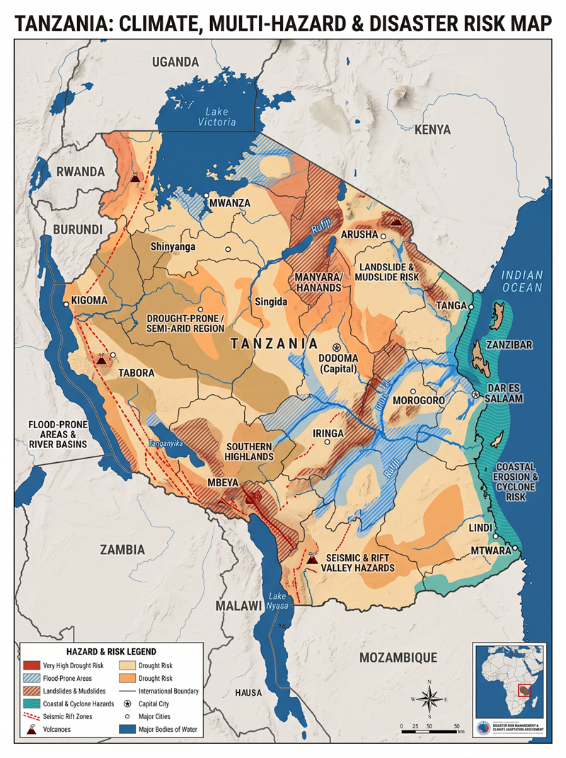
Tanzania faces a diverse disaster risk profile, with floods and droughts creating widespread pressures on livelihoods, infrastructure and public services. Rising temperatures, coastal change, landslides, disease outbreaks and geological hazards add further risks. Dependence on rainfed agriculture, settlement expansion into exposed locations and infrastructure constraints increase the potential consequences.
Tanzania has two broad rainfall regimes. The northern coast, northeastern highlands and Lake Victoria basin generally receive long rains in March-May and short rains in October-December. Much of central, southern and western Tanzania has one main rainy season, usually November-April/May. National assessments identify continued warming, while rainfall changes vary geographically and between climate scenarios.
The main hazards and their implications are outlined below. Locations indicate relevant areas for assessment; exposure and vulnerability vary considerably within each region.
| Hazard or risk area | Geographic focus | Main consequences |
|---|---|---|
| River, flash and urban flooding | River floodplains, including the Rufiji basin; Dar es Salaam, particularly settlements around the Msimbazi River; other inadequately drained urban areas. | Inundation of homes and farmland, displacement, damaged roads and bridges, and interrupted economic activity. NASA documented extensive Rufiji flooding in April 2024. |
| Drought and water scarcity | Central drylands, including Dodoma and Singida, alongside other areas experiencing prolonged rainfall deficits. | Reduced agricultural production, unreliable domestic water supplies and pressure on rural livelihoods. Water availability is a central adaptation concern in these dryland communities. |
| Extreme heat | Urban settlements, hot lowlands and outdoor working environments. | Heat-related illness, reduced labour productivity, livestock stress and greater pressure on water supplies. |
| Coastal flooding, erosion and saltwater intrusion | Mainland coastal settlements and Zanzibar, including Unguja and Pemba. | Damage to infrastructure, freshwater contamination and loss of coastal land. Ocean warming and coral bleaching also threaten fisheries and tourism. |
| Tropical cyclones and severe weather | Indian Ocean coastal areas and marine activities. | Heavy rainfall, strong winds and dangerous waves can combine with existing flooding. Cyclone Hidaya reached Tanzania in May 2024; WMO recorded 316.6 mm of rainfall at Kilwa on 4 May. |
| Landslides and debris flows | Steep slopes and settlements below unstable hillsides, illustrated by Hanang District in Manyara. | Rapid burial or destruction of settlements, fatalities, displacement and loss of access. The December 2023 Hanang disaster demonstrates the importance of assessing slope stability and downstream debris-flow routes. |
| Earthquakes and volcanic hazards | Rift-related areas, including Dodoma, Singida, Manyara and Arusha; localized volcanic exposure around Ol Doinyo Lengai. | Ground shaking threatens vulnerable buildings and infrastructure. Volcanic activity requires separate surveillance and site-specific preparedness. These hazards arise from geological processes. |
| Disease outbreaks, including cholera | Communities with inadequate safe water and sanitation, particularly where emergencies cause displacement or service disruption. | Contaminated water and sanitation failures can increase outbreak risks. WHO documented Tanzania among countries affected by cholera in January 2025. |
| Wildfire and ecosystem degradation | Forests, grasslands, wildlife habitats and surrounding livelihoods. | Uncontrolled fires can damage habitats and grazing resources. Drought and rising temperatures increase the need for fire detection and management. |
Several findings illustrate the scale of the development challenge:
- Recent disaster losses: Tanzania’s 2025 Disaster Risk Financing Framework reports approximately US$553 million in damage and losses from the 2023-2024 El Niño-related floods and Cyclone Hidaya. Transport accounted for the largest share.
- Urban exposure: The World Bank identifies approximately 463 km² of urban area at high flood risk, linking vulnerability partly to development on riverbanks and wetlands and inadequate drainage.
- Future poverty risk: The World Bank estimates that, without sufficient action, climate change could push an additional 2.6 million Tanzanians into poverty by 2050. This is a conditional projection, rather than an observed outcome.
For planning purposes, these hazards should also be assessed together. Relevant scenarios include severe rainfall following drought, simultaneous river and coastal flooding, and flood-related disruption of electricity, drinking water, health facilities and transport. Such scenarios help identify where failure of one service could undermine several others.
Tanzania already has institutions and programmes on which to build stronger risk management. Its Emergency Operation and Communication Center Situation Room in Dodoma was inaugurated on 14 June 2024. It was established to combine monitoring, forecasts and risk information to support warnings and early action. Planning instruments include the National Adaptation Plan 2025-2035 and Disaster Risk Financing Framework 2025-2030.
The financing framework’s documented starting gaps include inconsistent disaster-loss data collection tools, a centralized public-assets database lacking georeferencing, and fragmented institutional mandates. These findings indicate practical needs for better data integration and clearer links between responsibilities and resources.
Based on this evidence, the following are proposed priorities for assessment and investment:
- Maintain a national and local multi-hazard risk information system. Connect hazard maps with georeferenced households, infrastructure, livelihoods, vulnerability information and disaster-loss records. Assign custodians, update schedules and quality checks to each dataset.
- Verify observation and forecasting performance. Assess weather, river, coastal and geological monitoring coverage, equipment uptime, maintenance arrangements and data transmission. Evaluate forecast skill and usable warning lead time for priority locations.
- Develop sector-specific impact-based forecasting. Link forecasts to expected consequences for agriculture, livestock, water, health, transport, fisheries and settlements. Agree impact thresholds and protective actions with the agencies responsible for implementing them.
- Test warning delivery and community action. Check whether warnings reach people through accessible, redundant channels and whether recipients understand the required action. Validate evacuation routes, shelters and local procedures through exercises involving women, persons with disabilities, older people and remote communities.
- Connect risk governance to local planning and investment. Coordinate the PMO, Zanzibar’s responsible institutions, TMA, sector agencies and local authorities through agreed responsibilities and budgets. Prioritize drainage, floodplain management, water security, slope safety, resilient construction and ecosystem protection using local risk evidence.
- Link anticipatory action to accessible finance. Establish agreed triggers, authorized actions and funding procedures before emergencies. Track both economic losses and effects on health, education, displacement, ecosystems and cultural assets to inform recovery and future investment.
Implementation should be measured through verified warning reach, available lead time, completed protective actions, functioning critical services, financing release times and reductions in disaster losses. These measures would help determine whether improved information is translating into greater protection for communities.
Disaster Management Coordination Department

Objective
To rescue the Nation from disasters and emergencies.
Functions
This Division will perform the following functions:-
To coordinate disaster preparedness and responsiveness in the Country; and
To carry out rapid damage, needs assessment and recovery activities.
This Division will be led by a Director and will have three (3) Sections:-
- Operations and Coordination Section;
- Disaster Research Section; and
- Emergency Operation and Communication Centre Section.
- Operations and Coordination Section
This Section will perform the following activities:-
- Prepare, co-ordinate and implement plans for disaster preparedness and response activities and monitor their implementation;
- Co-ordinate MDAs and other stakeholders on disaster preparedness and response operations;
- Develop strategies for resource mobilization, solicit funds and administer distribution and utilization of funds and relief supplies;
- Conduct post disaster trauma; and
- Account for funds, goods and services provided as relief for disaster victims.
- This Section will be led by an Assistant Director.
Disaster Research Section
This Section will perform the following activities:-
- Carry out research in areas that are prone to disasters in liaison with professionals and advise the Government;
- Develop and implement strategies for mitigating disasters in prone areas;
- Co-ordinate MDAs and other stakeholders on disaster preparedness;
- Carry out damage and needs assessments and advise accordingly;
- Collect and maintain data related to disasters for forecasting and early warnings and provide feedback to relevant authorities;
- Provide mapping on hazards and vulnerabilities for risk management and provide feedback to relevant authorities;
- Follow-up on global research trends on Disaster Management and advise accordingly; and
- Plan and conduct public awareness on disasters.
This Section will be led by an Assistant Director.
Emergency Operation and Communication Centre Section
This Section will perform the following activities:-
Receive, analyse and disseminate disaster emergency information from within and outside Tanzania;
Provide early warning of any foreseen disaster;
Assess and monitor incident situation and advise accordingly;
Provide command and control of national disaster operations;
Develop protocols for managing operations of centre during impending and in emergency situation;
Coordinate and establish sub and visual operation centres; and
Coordinate and disseminate information concerning disaster issues.
This Section will be led by an Assistant Director.
Tanzania Climate Change and Multi Hazard Risk related documents
Community co-design for Early Warning Systems in Tanzania
Community co-design for Early Warning Systems in Tanzania – a conversation with Sunayana Sen, Programme Manager at Resurgence
Informal urban settlements in Dar es Salaam
Dar es Salaam, located in eastern Tanzania, is a coastal city with a population of around 4.5 million. It is the country’s largest city, as well as its economic hub.
In Dar es Salaam, over 70 per cent of households live in unplanned or informal structures. Informal urban settlements are highly exposed and susceptible to extreme weather events such as flooding, increased temperatures, droughts, and extreme and inconsistent rainfall. These events can have impacts including loss of life, reduced productivity, displacement and negative health effects. These factors are magnified by other risk factors such as high population density, structurally unsafe houses, poor building materials, and inadequate sanitation and solid waste management.
In addition, these communities have limited access to information on weather and the climate, as well as essential services such as health care, and have low-income levels.
Weather forecasting in Tanzania, as in much of East Africa, is typically focused on specific sectors such as agriculture and aviation as opposed to the needs of urban residents, meaning there is a disconnect between the information produced and the urban population that uses it. With the rapid urban growth of cities, leading to an increased need for weather and climate information, the country’s National Meteorological and Hydrological Services needed to work with urban communities to co-develop information that was relevant for urban spaces.
The DARAJA (Developing Risk Awareness through Joint Action) system
DARAJA, which means “bridge” in Swahili, is a service and partnership that aims to improve weather and climate information services, including early extreme weather warnings for urban users.
Adopting a systems-wide approach, DARAJA builds “bridges” and operational partnerships between critical actors in the co-design of the products, dissemination channels and feedback loops for weather forecasts and extreme weather alerts.
Rather than viewing residents as the last mile of a linear system, we took a dynamic information ecosystem approach, with users in the central role. This has resulted in a system that is user-centric, inclusive and collaborative, and ultimately produces information that populations at high risk can use.
Understanding the people at the centre
The purpose of the baseline research was to design user-centric services. We wanted the research findings to lead the design. In Dar es Salaam, we implemented DARAJA over two-and-a-half years, spending approximately six months at the beginning carrying out our baseline research and initiating relationships.
After an initial round of research, we worked with community members to test and revise our survey questions and translate them into Swahili. We hired local enumerators and trained them to conduct surveys. We then took the research findings to the stakeholders in a multi-stakeholder workshop setting to analyse and validate them.
First and foremost, we found that many people were not able to access forecasts or early warnings. Either they didn’t know where to actively look for them, or weren’t even passively receiving the information in any useful way.
Secondly, they weren’t able to understand the forecasts or early warnings. Even those who could access them, [SS1] had difficulty [LH2] understanding them, due to too much scientific or meteorological jargon.
Language itself was also an issue. Swahili is the predominant language in Dar es Salaam and, while many residents speak and understand English fairly well, Swahili is the language that they’re most comfortable with.
The relevance of the information was also important. Before DARAJA, the forecasts issued were for the entire city of Dar es Salaam. However, cities have microclimates, and temperature or rainfall forecasts differ for different parts of the city. Users are therefore more interested in understanding what the weather will look like for their neighbourhood. Citywide forecasts mean that they are not able to take specific actions that are relevant to them, or can lead them to think the information is inaccurate and therefore not see these forecasts as credible.
Because forecasts were previously for a large area, it did probably rain in some other area of the city – but it didn’t rain in your area. This does not necessarily mean the forecast is inaccurate. Then there’s the issue of probability, and the community’s understanding of it, when it comes to rain.
Thirdly, we saw a bit of an issue around the use of weather information to take action. I think that’s really the most important part of this. Improve the access and understanding of weather information, and only then will people be in a position to use this information to take action. Actions can range from something as significant as relocation or evacuation, to something smaller but impactful like moving your assets or household items to a higher position in your house to prevent them being damaged by floods.
Community-led solutions
In a workshop, we co-designed three to four communication solutions. We let the research findings and the community guide our implementation decisions. The solutions included improved weather broadcasts on national radio, a phone tree system using SMS and WhatsApp, public awareness campaigns, and embedding weather information within schools.
The schools pilot, as we refer to it, was a particularly endearing component of our project. We worked with six to eight schools across the city. This pilot involved training teachers and groups of students, usually through the schools’ environment clubs, to access forecasts and improve their understanding of this information and what it meant for their school communities.
Several schools said that, during the rainy season, many of their students’ materials tended to get destroyed when they get wet in the rain on their way to or back home from school, or that students’ belongings might get damaged by flood water when they leave them at home.
So, this was a recurrent problem. Based on the information they had gotten from the National Meteorological Service of Tanzania, the Tanzania Meteorological Authority (TMA), some of the schools decided to create spaces within their grounds for students to store their materials on particularly rainy days, so that students wouldn’t have to carry them in the rain, and they wouldn’t get wet or damaged by flooding in students’ homes.
The TMA was actively involved in this project, providing several training workshops. To bring it full circle, we carried out an endline evaluation. At the end, we held workshops to go over the findings, collectively assess the project and make plans to continue some of these activities.
Getting and sustaining stakeholder buy-ins
In terms of practical actions, we had to spend time with each individual stakeholder to build up that relationship and get a buy-in. Key stakeholders included the TMA, the informal settlement community, the city authorities, a few media houses and some other stakeholders in the city system. The Centre for Community Initiatives (CCI) was the main implementation and intermediary partner, facilitating partnership-building among the stakeholders.
The partnerships between these stakeholders developed and flourished as, ultimately, we were all working towards the same goal – that is, providing better services for communities in Dar es Salaam.
DARAJA’s (and the project’s) aim of reducing loss of life, livelihoods and assets was very much in line with TMA’s goals of providing better forecasts and information to the general public and other stakeholders, and similarly, it was aligned to the city authorities’ goal of providing better services.
Community ownership
The number-one best practice is to keep communities at the centre of the project. I think that’s our biggest lesson, and the key element of the success of DARAJA and any other model like it. We are constantly learning different ways in which we can do this.
The second most important practice is working with local partners. In every place we work, the context is different, and I wouldn’t presume to know everything about it. Local partners are very much embedded in communities and have a greater understanding of them.
The collaborative relationships developed between these stakeholders have been sustained by a feeling of community ownership, lasting beyond the closure of the project.
Multi-hazard early warning service (MHEWS) Tanzania
The purpose of the MHEWS Tanzania project was to enhance the capacity of the Tanzania Meteorological Agency (TMA) to reduce the impacts of extreme weather on coastal regions of Tanzania.
Much of the population in Tanzania is vulnerable to weather and climate related hazards including flooding, drought, landslides, lightning and disease. Early warning of severe weather is vital as disasters may occur when communities face natural hazards but are not prepared for the impacts.
The project initially focussed on the pilot sectors of marine, fishing, agriculture, oil and gas, and the public weather service. The TMA and the Met Office worked closely with sector stakeholder partners as well as representatives from the Disaster Management Department to understand requirements and jointly develop relevant early warning products and services.
Project reports/documentation
Blog, May 2016 – Severe Weather Events – Effective Planning (SWEEP) workshop with key stakeholders. Read the blog by Met Office Regional International Development Manager for Africa, Kathrin Hall.
Blog, April 2018 – Supporting the delivery of an early warning system through co-production and user engagement. Read the blog by Met Office International Development Manager, Becky Venton.
Impact case study, April 2018 – MHEWS: the right message, at the right time
MHEWS product – example of a product from the Tanzania Meteorological Agency (TMA) – November 2018
MHEWS Tanzania project summary
Impact case study, March 2019 – Tanzania Meteorological Agency successfully scales delivery of improved weather forecast
MHEWS Project Infographic – December 2021
You may also be interested in the following websites:
African Climate Policy Centre (ACPC)
Building Resilience & Adaptation to Climate Extremes & Disaster (BRACED)
Foreign, Commonwealth and Development Office (FCDO)
Future Climate for Africa (FCFA)
To,
Mr. Brigadier General Hosea Ndagala.
The Director of the Disaster Management Department ( Tanzania’s Prime Minister’s Office)
Subject: Working opportunity with the Disaster Management Coordination Department
Dear Sir,
Greetings from the Multi-Hazard Early Warning System Design and Implementation Center (MHEWC).
MHEWC provides technical solutions to strengthen Disaster Risk Management (DRM) governance systems, climate and multi-hazard risk management, and the design and implementation of end-to-end early warning systems. We would be pleased to offer technical support to the Disaster Management Coordination Department in the following areas:
a) Upgrading DMCD’s existing web portal into a geospatial, database-driven, and app-enabled Decision Support System (DSS) to support real-time disaster risk governance, planning, preparedness, response, and recovery management.
b) Conducting climate and multi-hazard risk and vulnerability assessments, including the preparation of geospatial hazard, exposure, vulnerability, and risk maps, and the establishment of a centralized risk information repository and database management system.
c) Assessing existing monitoring, observation, and early warning capacities and supporting NDMC in the installation, enhancement, and integration of observation networks, including Automated Weather Stations (AWS), hybrid weather and hazard monitoring systems, and sensor-ingested real-time data systems linked to a functional DSS.
d) Designing and operationalizing end-to-end multi-hazard early warning systems, including weather and hazard nowcasting services, impact-based forecasting, forecast-based anticipatory early action, forecast-based emergency preparedness and response management, forecast-based financing, Early Action Protocol development, and DSS-supported Standing Orders on Disaster and Standard Operating Procedures.
e) Supporting automated hazard detection, monitoring, prediction, and emergency operations management, including the design, implementation, and operationalization of a Multi-Hazard and Disaster Emergency Operations Center (EOC).
f) Developing GIS, database, and information tool-driven local government and productive sector-level risk-informed planning and budgeting systems to strengthen disaster risk reduction, climate change adaptation, nature-based solutions, locally led adaptation, and resilience planning.
g) Reviewing and upgrading multi-hazard preparedness, response, and recovery plans across administrative levels and relevant priority sectors, in alignment with DMCD’s institutional mandate and national disaster management priorities.
h) Providing any additional technical assistance as may be required by DMCD to strengthen national-to-last-mile disaster risk governance and early warning capacities.
We would welcome the opportunity to discuss DMCD’s priorities and explore how MHEWC can support the development of a practical implementation roadmap for strengthening multi-hazard early warning, risk information, and disaster risk governance systems.
We look forward to your kind response.
Sincerely,
Z M Sajjadul Islam
Director & Advisor
Multi-Hazard Early Warning System Design and Implementation Center (MHEWC)
Web: https://www.mhewc.org/tanzania
Email: [ zmsajjad@gmail.com ][ sajjad@mhewc.org ]
Phone & WhatsApp: +88 01711 979179