Climate and multi-hazard risk and vulnerabilities
Peru is highly exposed and vulnerable to climate change and multi-hazard risks, especially El Niño/ENSO-related floods and droughts, riverine and flash floods, landslides, debris flows/huaycos, glacier retreat, glacial lake outburst floods, drought, frosts, cold waves/friajes, heatwaves, coastal flooding, earthquakes, water scarcity, forest fires, agricultural losses, fisheries disruption, public-health risks, and infrastructure damage. The World Bank notes that Peru is more exposed and vulnerable to natural hazards than many structural peers, with frequent earthquakes, floods, landslides and droughts, and high spatial concentration of people and assets in risky locations. (World Bank)
Peru’s risk profile is strongly shaped by its geography: the Pacific coastal desert, the Andean highlands, and the Amazon/Selva each face different but interconnected hazards. The coast is highly exposed to El Niño rainfall, floods, coastal flooding, water scarcity and urban risk; the Andes are exposed to glacier retreat, landslides, GLOFs, frosts, drought and rural livelihood stress; and the Amazon is exposed to floods, drought, forest degradation, heat, fires, disease risks and ecosystem loss.
Peru’s climate-risk profile is defined by high ENSO exposure, severe flood and landslide risk, glacier retreat, water-security stress, climate-sensitive agriculture and fisheries, vulnerable Andean and Amazon communities, and major infrastructure exposure. Peru has a strong policy foundation through its NAP and climate-risk planning architecture, but resilience will depend on operationalizing impact-based forecasting, hydromet modernization, glacier monitoring, resilient water systems, climate-smart agriculture, fisheries adaptation, forest protection, health surveillance, and forecast-based early action.
Key hazard profile
| Hazard | Main risk pathway | Highly exposed areas / systems |
|---|---|---|
| El Niño / ENSO | Heavy rainfall, floods, landslides, infrastructure damage, crop losses, fisheries disruption, disease outbreaks | Northern coast, Lima, Piura, Tumbes, Lambayeque, La Libertad, coastal valleys, Andes |
| Floods and huaycos | Loss of life, housing damage, road/bridge failure, irrigation damage, WASH contamination | Coastal river valleys, Andean slopes, informal settlements, transport corridors |
| Landslides and mass movements | Road blockages, village damage, isolation of communities, infrastructure losses | Andean regions, steep valleys, mining corridors, rural roads |
| Glacier retreat and GLOFs | Sudden lake outburst floods, dry-season water decline, hydropower and irrigation stress | Cordillera Blanca, Ancash, Cusco, Apurímac, glacier-fed basins |
| Drought and dry spells | Crop failure, pasture stress, water shortages, food insecurity, hydropower stress | Central/southern Sierra, southern Andes, Amazon dry-spell areas |
| Frosts, cold waves and friajes | Crop and livestock losses, respiratory illness, mortality risk among vulnerable groups | High Andes, Puno, Cusco, Huancavelica, Apurímac, Amazon communities during friaje |
| Heatwaves | Heat illness, labour productivity loss, water demand, urban heat stress | Lima, northern coast, Amazon cities, outdoor workers |
| Coastal and marine hazards | Coastal flooding, erosion, storm surge, fisheries disruption, port impacts | Lima-Callao, northern coast, coastal fishing communities |
| Earthquakes and tsunamis | Structural collapse, cascading urban disaster, coastal evacuation needs | Pacific coast, Lima-Callao, southern coast, seismic belt |
| Forest fires and ecosystem degradation | Biodiversity loss, smoke exposure, forest degradation, livelihood impacts | Andes-Amazon transition zones, dry forests, Amazon frontier |
Climate trends and exposure
Peru’s climate is already changing. Since the 1960s, average temperatures have increased by around 1°C, and further warming is projected this century. Maximum temperatures are projected to increase by 2°C–3°C and minimum temperatures by 4°C–6°C by around 2065, with faster warming along the coast and in the southeastern Andes. Rainfall projections vary by region, but Peru is expected to face greater hydrological variability, with more intense rainfall in some areas and more frequent drought and dry spells in others. (Interactive Country Fiches)
Observed hazard trends already show intensification. The number of intense rainstorms, mudflows and forest fires has more than doubled in the past decade, while floods have increased by around 60% since the 1970s. Climate change is expected to increase the frequency and intensity of floods, droughts and ENSO-related extremes. (Interactive Country Fiches)
Peru is one of the countries most affected by El Niño, which is associated with increased floods in the Costa/coastal region and drought impacts in the Sierra. The 1982–83 and 1997–98 El Niño episodes caused an estimated US$6.8 billion in losses, while the 2017 coastal El Niño caused around US$3.1 billion in losses, equivalent to 1.6% of GDP, damaging roads, houses, bridges, farmland, schools, irrigation canals, rural roads and health facilities. (World Bank)
Sector-specific vulnerabilities
1. Water resources, glaciers and hydropower
Water security is one of Peru’s most serious long-term climate risks. Peru contains about 71% of the world’s tropical glaciers, which are critical for Andean hydrology because they store water during the rainy season and release it during the dry season. Glacier retreat is already reducing this natural water-regulation function, increasing the risk of rainy-season floods and glacial lake outburst floods while reducing dry-season water availability for drinking water, irrigation and hydropower. (Interactive Country Fiches)
This creates a dual risk: in the short to medium term, glacier retreat can increase flood and GLOF risk; over the longer term, declining glacier storage threatens dry-season water supply. Peru’s hydropower system is also exposed because a significant share of electricity generation comes from glacier-fed river basins, including the Cañon del Pato, Mantaro and Urubamba systems. (Interactive Country Fiches)
The World Bank also highlights Peru’s limited water-storage capacity, noting that it is only around 18% of the Latin America and Caribbean average. Strengthening multipurpose water storage, groundwater recharge, watershed conservation, water-use efficiency and climate-informed allocation is therefore central to adaptation. (World Bank)
2. Agriculture, food security and rural livelihoods
Agriculture is highly climate-sensitive and central to livelihoods, employment and exports. The World Bank reports that agriculture contributes around 6% of GDP, 24% of exports and 27% of employment, but is highly exposed to climate change. Climate impacts could reduce agricultural productivity by an average of about 5% by 2050. (World Bank)
The Sierra is especially vulnerable because many smallholder and Indigenous farming communities depend on rain-fed agriculture, traditional crops, livestock and fragile mountain ecosystems. Drought, frosts, cold waves, hailstorms, floods and landslides affect potatoes, maize, barley, beans, quinoa, pasturelands and livestock. In the coastal valleys, export-oriented agriculture faces water scarcity, drought, salinization, flood damage and irrigation-infrastructure disruption. (Interactive Country Fiches)
Key agricultural vulnerability pathways include crop-yield decline, pest and disease expansion, genetic erosion of native varieties, irrigation damage, reduced pasture productivity, livestock mortality during frost/cold waves, and rising costs for water, pesticides and climate-risk management.
3. Fisheries, aquaculture and marine ecosystems
Peru is one of the world’s most important fishing countries and is a major producer/exporter of anchovy fishmeal. The World Bank notes that Peru is the world’s third-largest fish producer and the largest exporter of anchovy fishmeal, while agriculture and fisheries exports together increase the country’s vulnerability to climate change. (World Bank)
The anchovy fishery is highly sensitive to ocean temperature, marine heat, El Niño events, ocean acidification and changes in primary productivity. During strong El Niño years, warm sea-surface temperatures can sharply reduce anchovy availability and disrupt the marine food chain, with serious consequences for fisheries, employment, exports, food security and coastal livelihoods. (Interactive Country Fiches)
4. Floods, landslides, huaycos and infrastructure
Floods, landslides and huaycos are among Peru’s most damaging rapid-onset hazards. They affect roads, bridges, schools, health facilities, irrigation canals, rural paths, power lines, housing and water systems. The 2017 coastal El Niño event damaged nearly half of Peru’s road network, creating cascading impacts on logistics, market access, emergency response and public service delivery. (World Bank)
Transport vulnerability is especially high because Peru’s mountainous geography makes roads expensive to build and maintain, and many rural communities depend on a limited number of exposed corridors. When roads or bridges fail, communities may lose access to food markets, health care, education, agricultural inputs and emergency assistance.
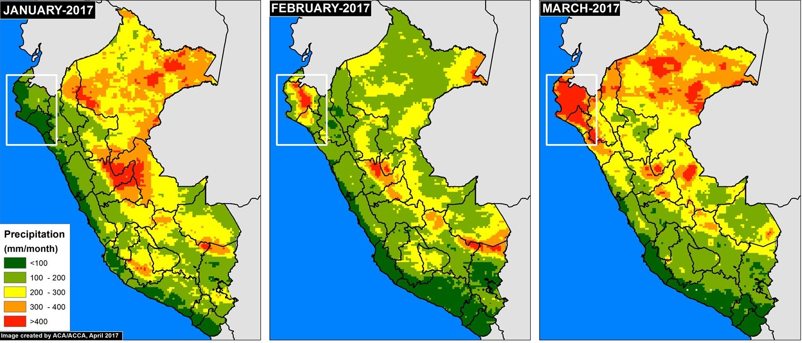
Image 58b shows the resulting accumulated monthly precipitation totals (white inset box indicates primary flooding zone). In January, as expected, the dry northern coast had much lower precipitation than the Amazon region to the east. In February and March, however, the northern coast experienced abnormally intense rainfall, even more than many parts of the Amazon. https://www.maapprogram.org/climate-flooding/
5. Urban vulnerability and informal settlements
Urban climate risk is concentrated in Lima-Callao, coastal cities, Andean valley cities and rapidly growing peri-urban settlements. Lima faces water scarcity, flash flooding, landslide-prone slopes, informal hillside settlements, heat stress, coastal exposure and seismic risk. Informal settlements are particularly vulnerable because housing is often built on unstable slopes, riverbanks, dry ravines or poorly serviced land.
Urban adaptation requires risk-sensitive land-use planning, slope stabilization, drainage improvement, safe relocation where necessary, floodplain regulation, resilient water systems, early warning, emergency routes, and stronger building-code enforcement.
6. Public health vulnerability
Climate change affects health through heat stress, flood-related disease outbreaks, water contamination, vector-borne diseases, food insecurity, respiratory illness during cold waves/friajes, and service disruption after disasters. Rising temperatures may expand the suitable range for diseases such as dengue, malaria and yellow fever, especially in the Amazon/Selva and northern coast. Severe storms and floods can also increase cholera and other water-borne disease risks. (Interactive Country Fiches)
Vulnerable groups include children, elderly people, pregnant women, Indigenous communities, high-altitude rural households, informal workers, people living in informal settlements, and communities with limited access to safe water, sanitation and health services.
7. Forests, biodiversity and Amazon vulnerability
Peru’s Amazon forests, dry forests, mountain ecosystems and marine-coastal ecosystems are highly climate-sensitive. The National Adaptation Plan identifies mountain ecosystems, dry forests, Amazon rainforests and marine-coastal ecosystems as among the most vulnerable ecosystems. (Interactive Country Fiches)
Deforestation, informal agriculture, illegal mining, forest fires, drought and land degradation reduce ecosystem resilience and increase disaster risk. The World Bank identifies agriculture as a leading driver of deforestation, with land-use change and forestry representing Peru’s largest source of greenhouse-gas emissions. (World Bank)
Forest and ecosystem protection are therefore adaptation measures as well as mitigation measures. Healthy forests regulate rainfall, protect watersheds, reduce erosion, support Indigenous livelihoods, conserve biodiversity and reduce flood and drought impacts.
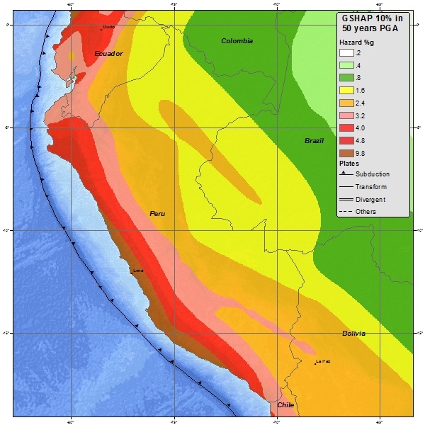
Seismic Map Peru https://commons.wikimedia.org/wiki/File:Peru_seismic_hazard_map.jpg
Exposure, sensitivity and adaptive capacity
Exposure
Peru is exposed to both slow-onset climate stressors and rapid-onset hazards. Slow-onset stressors include glacier retreat, water scarcity, drought, temperature rise, sea-level rise, forest degradation and ecosystem change. Rapid-onset hazards include El Niño floods, huaycos, landslides, intense rainfall, earthquakes, tsunamis, cold waves, frosts and forest fires.
Sensitivity
Sensitivity is high because Peru’s economy and livelihoods depend heavily on climate-sensitive sectors: agriculture, fisheries, hydropower, mining logistics, tourism, forests and water resources. Rural poverty, Indigenous marginalization, informal labour, limited basic services, and uneven infrastructure access further increase vulnerability. The World Bank notes that informality, inequality and low access to safe water and sanitation reduce Peru’s resilience to climate shocks. (World Bank)
Adaptive capacity
Peru has important climate-policy foundations. Its National Adaptation Plan prioritizes water, agriculture, fisheries and aquaculture, forests, health, tourism and transport. Peru’s adaptation monitoring and evaluation roadmap also aligns the NAP with the NDC and includes sectoral indicators and goals for tracking progress. (IISD)
However, implementation gaps remain in local-level risk governance, hydromet modernization, glacier and GLOF monitoring, integrated water management, informal settlement risk reduction, climate-resilient infrastructure, Indigenous-inclusive adaptation, and forecast-based anticipatory action.
Priority adaptation and early warning needs
Peru’s resilience pathway should focus on an end-to-end, impact-based, multi-hazard early warning system adapted to coastal, Andean and Amazon risk contexts.
Key priorities include:
ENSO/El Niño impact-based forecasting
Link ocean-atmosphere forecasts with flood, drought, landslide, fisheries, agriculture, health and infrastructure impact models.Flood, huayco and landslide early warning
Develop basin-level rainfall thresholds, river gauges, debris-flow monitoring, slope-risk mapping, community sirens, evacuation routes and local response protocols.Glacier and GLOF monitoring
Expand satellite monitoring, automatic lake-level sensors, moraine-dam stability assessments, downstream exposure mapping and evacuation planning for glacier-fed basins.Drought and water-scarcity early warning
Integrate rainfall, snow/glacier melt, reservoir storage, groundwater, soil moisture, crop water demand, streamflow and seasonal forecasts.Climate-smart agriculture and livestock systems
Promote drought-tolerant and frost-resilient crops, water-efficient irrigation, protected agriculture, agroforestry, pest surveillance, livestock shelters, pasture management and climate-index insurance.Fisheries and marine climate services
Strengthen ocean-temperature monitoring, anchovy biomass forecasting, harmful algal bloom monitoring, fisheries advisories and adaptive fisheries management.Health-climate surveillance
Link weather and climate data with dengue, malaria, diarrhoeal disease, heat stress, friaje/cold-wave risks, malnutrition and flood-related health alerts.Resilient infrastructure and transport corridors
Climate-proof roads, bridges, schools, health facilities, irrigation canals, water systems and power infrastructure against floods, landslides, earthquakes and extreme rainfall.Urban risk reduction
Improve drainage, slope stabilization, land-use controls, safe housing, relocation support, floodplain management and early warning for informal settlements.Geospatial Decision Support System
Build a national DSS integrating hazard forecasts, ENSO scenarios, glacier lakes, river basins, landslide susceptibility, exposed infrastructure, agriculture zones, fisheries zones, health facilities, vulnerable populations and early-action triggers.
DISASTER RISK MANAGEMENT AT OSIPTEL

Aim
The objective of Disaster Risk Management (DRM) is to prevent or reduce risk factors, avoid the generation of new risks, and carry out adequate preparation, response, rehabilitation, and reconstruction in disaster situations, as well as minimize adverse effects on the population, the economy, and the environment.
Importance
Risk management allows for the prevention of internal or external threats that may affect the organization, and subsequently, the creation of strategies that minimize risks.
Disaster risk management at OSIPTEL
The Working Group for Disaster Risk Management has been formed, which is an internal space for coordination in the formulation of standards and plans, evaluation and organization of processes for Disaster Risk Management within the scope of competence of OSIPTEL.
Designation of the Technical Team for the preparation of the OSIPTEL Disaster Risk Prevention and Reduction Plan – Resolution 337-2023-GG/OSIPTEL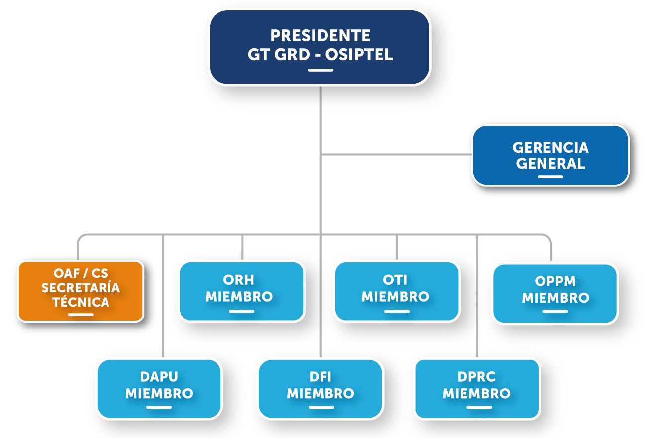
Marco Normativo
- Ley Nº 29664, Ley que crea el Sistema Nacional de Gestión del Riesgo de Desastres (SINAGERD) y su Reglamento (Decreto Supremo Nº 048-2011-PCM).
- Decreto Supremo Nº 034-2014-PCM, que aprueba el Plan Nacional de Gestión del Riesgo de Desastres – PLANAGERD 2014 – 2021.
- Resolución Ministerial Nº 276-2012-PCM, que aprueba la Directiva Nº 001-2012-PCM/SINAGERD “Lineamientos para la Constitución y Funcionamiento de los Grupos de Trabajo de la Gestión del Riesgo de Desastres en los Tres Niveles de Gobierno”.
- Resolución Ministerial Nº 059-2015-PCM, que aprueba los “Lineamientos para la Organización y Funcionamiento de los Centros de Operaciones de Emergencia – COE”.
- Resolución Ministerial Nº 185-2015-PCM, que aprueba los “Lineamientos para la Implementación de los Procesos de la Gestión Reactiva”.
- Resolución Ministerial Nº 136-2020-PCM, que aprueba los “Lineamientos para la formulación y aprobación de los planes de operaciones de emergencia”.
- Resolución de Presidencia Nº 0083-2019-PD/OSIPTEL, que constituye el Grupo de Trabajo para la Gestión del Riesgo de Desastres del OSIPTEL.
- Resolución de Presidencia Nº 00115-2021-PD/OSIPTEL, que reconforma el Grupo de Trabajo para la Gestión del Riesgo de Desastres del OSIPTEL, con la inclusión de la Oficina de Recursos Humanos.
Specific Plans
Public entities must formulate, approve and implement the following plans:
Disaster Risk Prevention and Reduction Plan.
The National Disaster Risk Management System is an inter-institutional, synergistic, decentralized, cross-cutting and participatory system, created with the purpose of identifying and reducing risks associated with hazards or minimizing their effects and preventing the generation of new risks, as well as preparing for and responding to disaster situations, through the establishment of principles, policy guidelines, components, processes and instruments of DRM.
Preparation Plan.
It consists of the set of actions of planning, capacity development, organization and efficient operation of the institution, and resource management, to anticipate and respond efficiently and effectively in case of disaster (Security Plan, Awareness and Dissemination Plan, drills).
Emergency Operations Plan.
Cross-cutting activities aimed at leading and coordinating disaster response, generating decisions that are transformed into response actions.
Rehabilitation Plan.
A set of actions and activities carried out by OSIPTEL in the event of an emergency or disaster, immediately after it occurs; as well as the procedures to monitor the continuity of service provision by the operating companies and/or its restoration in the most expeditious way possible, in addition to keeping users informed.
Contingency Plan.
Planning of coordination actions that allow articulating the response capacity established in OSIPTEL (Response Protocols).
Escenarios de riesgo por inundaciones y movimientos en masa en el marco del Plan Multisectorial 2025-2027
El presente informe tiene por objetivo desarrollar el escenario de riesgo por inundaciones y movimientos en masa a nivel nacional frente a la ocurrencia de anomalías porcentuales de lluvias asociadas a eventos El Niño / La Niña de mayor impacto en el Perú.
Basic Concepts
What is SINAGERD?
The National Disaster Risk Management System is an inter-institutional, synergistic, decentralized, cross-cutting and participatory system, created with the purpose of identifying and reducing risks associated with hazards or minimizing their effects and preventing the generation of new risks, as well as preparing for and responding to disaster situations, through the establishment of principles, policy guidelines, components, processes and instruments of DRM.
What is the composition of SINAGERD?
Presidency of the Council of Ministers – PCM.
National Council for Disaster Risk Reduction – CONAGERD.
National Center for Strategic Planning – CEPLAN.
National Center for Disaster Risk Estimation, Prevention and Reduction – CENEPRED.
National Institute of Civil Defense – INDECI.
Regional and Local Governments.
Armed Forces and National Police.
Public, Private and Civil Society Entities.
Disaster Risk Management Processes
- Risk assessment: Includes actions to generate knowledge of hazards, analyze vulnerability, and establish risk levels.
- Risk prevention: Includes actions aimed at preventing the generation of new risks.
- Risk reduction: These are actions aimed at reducing existing vulnerabilities and risks.
- Preparedness: Actions taken to ensure an optimal response from society in the event of disasters.
- Answer: These are actions that are carried out in the face of a disaster (immediately after it occurs, or in the proximity of it).
- Rehabilitation: These are actions carried out to restore essential basic services, allowing activities in the affected area to return to normal.
- Reconstruction: These are actions that are carried out to establish sustainable development conditions in the affected areas, reducing the risk prior to the disaster and ensuring recovery.
Disaster
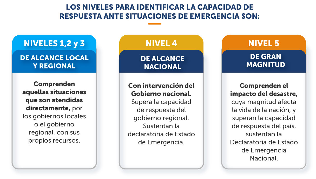
A set of damages and losses in health, livelihoods, physical habitat, infrastructure, economic activity and the environment, which occurs as a consequence of the impact of a hazard or threat whose intensity generates serious alterations in the functioning of social units, exceeding the local response capacity to effectively address its consequences, and which may be of natural origin or induced by human action.
Emergency
State of damage to life, property and the environment caused by the occurrence of a natural phenomenon or induced by human action that alters the normal development of activities in the affected area.
Danger
Probability that a potentially harmful physical phenomenon, of natural origin or induced by human action, will occur in a specific place, with a certain intensity and in a defined period of time and frequency.
Disaster risk
It is the probability that the population and their livelihoods will suffer damage and losses as a result of their vulnerability and the impact of a hazard.
Vulnerability
It is the susceptibility of the population, the physical structure or the socio-economic activities to suffer damage from the action of a hazard or threat.