Guyana Climate and multi-hazard risk and vulnerabilities
Guyana is one of the most climate-exposed countries in South America and the Caribbean region, especially because its population, agriculture, public infrastructure and economic activity are heavily concentrated on a low-lying Atlantic coastal plain. The country is particularly vulnerable to coastal flooding, sea-level rise, storm surge, riverine flooding, urban/pluvial flooding, drought, extreme rainfall, saltwater intrusion, coastal erosion, heat stress, water-borne disease risks, agricultural losses, mangrove degradation, and infrastructure disruption. The World Bank notes that Guyana’s rising sea levels expose 100% of coastal agriculture and 66.4% of coastal urban areas to flooding and erosion, with potential GDP losses that could exceed 46.4%. (World Bank)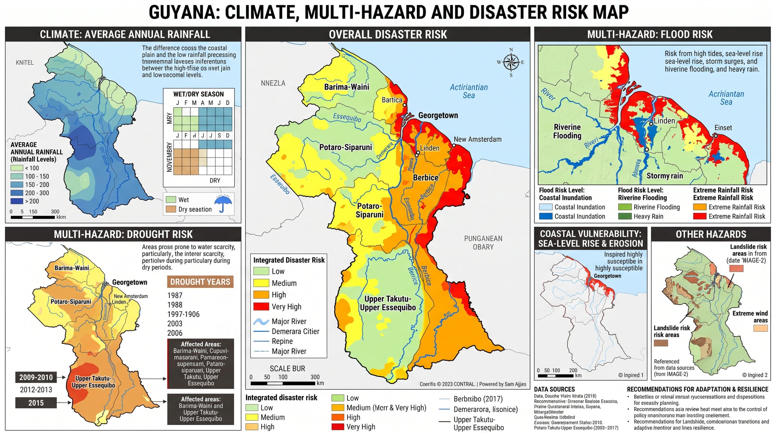
Guyana’s climate-risk profile is defined by a very difficult drainage reality: much of the coastal zone lies below sea level, depends on seawalls, mangroves, canals, culverts, sluices/kokers and pumps, and can discharge water by gravity only during low tide. As sea level rises and heavy rainfall events intensify, the window for safe drainage becomes shorter, increasing the probability of compound flooding from rainfall, river discharge, tide and coastal surge.
Guyana’s climate-risk profile is defined by extreme coastal concentration, low-lying settlement and agriculture, sea-level rise, drainage constraints, flood-prone urban systems, drought-sensitive hinterland communities, mangrove dependence, and climate-sensitive agriculture and fisheries. The country has strong strategic foundations through its LCDS, coastal resilience investments and NAP process, but long-term resilience will depend on shifting from infrastructure repair alone to integrated coastal-zone management, impact-based forecasting, nature-based protection, climate-smart agriculture, public-health preparedness, risk-informed land-use planning and forecast-based early action.

Key hazard profile
| Hazard | Main risk pathway | Highly exposed areas / systems |
|---|---|---|
| Coastal flooding and sea-level rise | Overtopping, erosion, saltwater intrusion, damage to homes, farms, roads and drainage systems | Georgetown, Demerara-Mahaica, Essequibo Islands-West Demerara, Mahaica-Berbice, East Berbice-Corentyne |
| Urban/pluvial flooding | Drainage overload, road disruption, property damage, water contamination, health risks | Georgetown and low-lying coastal towns |
| Riverine flooding | Inundation of farms, villages and riverbank settlements; crop and livestock losses | Interior river systems, Amerindian communities, low-lying river corridors |
| Drought and dry spells | Crop stress, reduced water availability, livestock impacts, hinterland water scarcity | Rupununi, savannahs, interior communities, rice and sugar zones |
| Saltwater intrusion | Salinization of rice fields, freshwater contamination, coastal agriculture damage | Coastal rice, sugar, aquaculture and drainage-irrigation areas |
| Extreme rainfall | Flooding, erosion, landslide/local slope instability, drainage failure | Coastal plain, river basins, urban settlements |
| Heat stress | Health impacts, labour productivity loss, livestock stress, crop yield reduction | Coastal urban areas, farms, outdoor workers, hinterland communities |
| Mangrove loss and coastal erosion | Reduced natural coastal protection, increased flood and storm-surge exposure | Atlantic coast, mangrove-fringed shoreline, fishing communities |
| Public-health risks | Water-borne disease, vector-borne disease, heat illness, flood-related contamination | Flood-prone communities, poor households, hinterland settlements |
Climate trends and exposure
Guyana’s central exposure is geographic. Approximately 90% of the population lives on about 15,000 km² of low-lying coastal land along a coastline of about 459 km, and the majority of this coastal zone lies below sea level. Guyana’s Low Carbon Development Strategy notes that engineered seawalls and natural mangrove systems are both critical for protecting coastal communities, agriculture and fisheries infrastructure.
The drainage and irrigation system is also central to national resilience. More than 150 sluice gates/kokers are linked to the coastal drainage network, but sea-level rise reduces low-tide drainage opportunities, while blocked drains, aging infrastructure and disabled pumps further increase flood risk. The 2005 Georgetown flood exposed the system’s limitations under high rainfall combined with tidal inflow.
Sector-specific vulnerabilities
1. Coastal zone, Georgetown and drainage infrastructure
Guyana’s coastal plain is the country’s highest-risk zone because it concentrates people, public institutions, housing, transport links, agriculture, drainage assets and economic activity. Georgetown is especially vulnerable because it is low-lying, heavily urbanized, dependent on engineered drainage, and exposed to rainfall flooding, tidal backwater effects, sea-level rise and aging infrastructure.
The World Bank-financed Coastal Adaptation and Resilience Project is designed to reduce flood risk in the most vulnerable coastal regions and is expected to benefit around 320,000 people, about 40% of Guyana’s population. It will repair or replace more than 45 drainage infrastructure assets, focusing on sluices, while strengthening drainage operations, asset management and technical standards. (World Bank)
2. Agriculture, food security and rural livelihoods
Agriculture is one of Guyana’s most climate-sensitive sectors. The Low Carbon Development Strategy states that agriculture contributes about 31.9% of non-oil GDP, employs around 17% of the labour force, and generates about 21.3% of non-oil export earnings. Rice and sugar remain central subsectors, while fisheries are also important for livelihoods and dietary intake.
Climate risks affect agriculture through multiple pathways: sea-level rise can increase salinity in rice fields; higher temperatures can reduce rice yields; changing growing conditions can increase weeds and pests; drought can reduce yields; and intense rainfall and flooding can reduce planting and harvesting days. The 2021 floods affected more than 74,000 acres of farmland, including over 43,000 acres of cash crops and over 30,000 acres of rice, and affected more than 20,000 farmers.
3. Water security, drought and hinterland vulnerability
Although Guyana is often described as the “land of many waters,” drought is a serious and growing risk. Drought affects rice, sugar, livestock, savannah livelihoods, hinterland communities, river transport, drinking-water access and food security. In past droughts, rice and sugar industries experienced significant losses, and more than 1,500 Amerindian families in Southern Guyana dependent on agriculture were affected.
Hinterland and Indigenous communities are especially sensitive because livelihoods often depend on rainfall, river access, small-scale agriculture, fishing, forest resources and limited infrastructure. Guyana’s 2025 NAP validation process highlighted that hinterland regions and Indigenous communities face intensifying heat stress, shifting rainfall, drought, pests and diseases, with risks to livelihoods, infrastructure, ecosystems and cultural heritage. (News Room Guyana)
4. Mangroves, forests and ecosystem-based adaptation
Mangroves are a critical natural defence system. Guyana’s LCDS identifies mangrove restoration and protection as a core outcome for climate resilience because mangroves help defend the coast, support fisheries habitat and reduce flood exposure. DHI’s work on nature-based coastal protection notes that mangroves protect about 60% of Guyana’s coast from floods, but mangrove degradation increases coastal flooding and saltwater inundation of agricultural land. (DHI)
Guyana’s broader forest system is also globally significant. The LCDS describes Guyana as maintaining forests over about 85% of its territory, positioning the country as a high-forest, low-deforestation jurisdiction with a development strategy based on forest conservation, carbon markets, biodiversity and climate resilience. (lcds.gov.gy)
5. Public health and WASH vulnerability
Climate change affects health through flooding, contaminated water, drought-related water scarcity, heat stress, vector-borne disease, water-borne disease and disruption of health services. The WHO/PAHO health-and-climate profile for Guyana identifies the country as already experiencing severe floods and droughts, with additional risks from sea-level rise, changing precipitation patterns and disease impacts. (PreventionWeb)
Flooding can contaminate wells, drains, canals, latrines and surface-water sources. In dense coastal settlements, floodwater can also increase risks of diarrhoeal disease, skin infections, leptospirosis and mosquito-borne diseases. Heat stress is an increasing concern for outdoor workers, elderly people, children, persons with chronic illness and communities with limited access to cooling.
6. Infrastructure, transport and public services
Guyana’s infrastructure exposure is concentrated in the coastal zone. Roads, bridges, drainage structures, sea defences, schools, clinics, markets, ports, farms and housing are vulnerable to flooding, erosion and saltwater intrusion. The UN in Guyana notes that Georgetown’s drainage system is frequently overwhelmed, causing infrastructure damage and disruption to urban activities. (The United Nations in Guyana)
Transport and logistics are also vulnerable in the hinterland, where river transport, small bridges, unpaved roads and remote airstrips are essential for access to health care, education, markets and emergency response. Floods can isolate communities, while drought can reduce navigability of rivers and creeks.
7. Oil economy, fiscal exposure and resilience opportunity
Guyana’s rapid oil-led growth creates both opportunities and risks. On the opportunity side, higher public revenue can finance coastal protection, drainage modernization, resilient infrastructure, water management and social services. On the risk side, rapid urbanization, coastal infrastructure expansion, port development and public investment can increase exposure if they are not guided by climate-risk screening and resilient land-use planning.
The World Bank’s current country engagement with Guyana includes environmental resilience, transport, renewable energy, education, health and natural-resource management, aligned with the Low Carbon Development Strategy. (World Bank) This makes climate-proofing public investment especially important as the economy expands.
Exposure, sensitivity and adaptive capacity
Exposure
Guyana is exposed to both slow-onset risks and rapid-onset hazards. Slow-onset risks include sea-level rise, saltwater intrusion, coastal erosion, mangrove degradation, warming, drought and ecosystem stress. Rapid-onset hazards include heavy rainfall, urban flooding, riverine flooding, coastal overtopping, storm surge, drainage failure and localized windstorm damage.
Sensitivity
Sensitivity is very high because coastal agriculture, coastal settlements and national infrastructure are concentrated in areas that depend on engineered and natural flood protection. Agriculture, fisheries, drainage, water supply, health, transport and housing are all affected when flood, tide, salinity and rainfall hazards interact.
Adaptive capacity
Guyana has important policy foundations, including the Low Carbon Development Strategy 2030, disaster-risk management institutions, sea-defence and drainage programmes, mangrove restoration efforts, and the National Adaptation Plan process. In 2025, Guyana validated a long-term NAP covering 10 key sectors: agriculture and food security, water resources, coastal zones and the blue economy, health, education, ecosystems and biodiversity, land use and settlements, transportation, energy, and disaster risk management. (News Room Guyana)
However, implementation gaps remain in drainage maintenance, coastal monitoring, last-mile early warning, land-use planning, hinterland drought monitoring, community preparedness, public-health surveillance, resilient housing and climate-risk financing.
Priority adaptation and early warning needs
Guyana’s resilience strategy should focus on an impact-based, multi-hazard early warning system integrated with coastal protection, drainage management, agriculture, health, water resources and local disaster preparedness.
Key priorities include:
Coastal flood and sea-level monitoring
Strengthen tide gauges, coastal erosion monitoring, sea-defence condition assessment, storm-surge modelling, mangrove mapping and saltwater-intrusion surveillance.Urban flood impact-based forecasting for Georgetown
Combine rainfall forecasts, drainage capacity, pump status, canal levels, tide levels, road exposure, vulnerable settlements and critical facilities into actionable alerts.Drainage and irrigation modernization
Rehabilitate sluices/kokers, pumps, canals, culverts, outfalls and embankments, supported by asset-management systems and maintenance financing.Agriculture climate services
Provide rice, sugar, livestock, fisheries and cash-crop advisories linked to rainfall, salinity, drainage conditions, soil moisture, pests, drought and flood forecasts.Drought early warning for hinterland and savannah areas
Track rainfall deficits, water points, river levels, crop condition, vegetation stress, livestock conditions, food security and Indigenous community needs.Mangrove and nature-based coastal protection
Restore and protect mangroves, coastal wetlands and riparian buffers, and combine them with engineered sea defences where hybrid protection is needed.Health-climate surveillance
Link flood, heat, water quality and disease data with alerts for diarrhoeal disease, dengue, malaria, leptospirosis, heat stress and WASH risks.Risk-informed spatial planning
Avoid new high-value development in highly exposed coastal and flood-prone zones unless protected by climate-resilient infrastructure and long-term adaptation planning.Community-based early warning
Strengthen last-mile warning through local disaster committees, community radio, mobile alerts, river/flood markers, evacuation routes, shelters and locally understood thresholds.Geospatial Decision Support System
Build a national DSS integrating coastal elevation, drainage assets, sea defences, mangroves, flood maps, river levels, agriculture zones, vulnerable communities, schools, health facilities, roads, pumps, sluices and early-action triggers.
Disaster Management in Guyana
Disaster Risk Management (DRM) in Guyana is coordinated by the Office of the Prime Minister and the Civil Defence Commission (CDC). Through a partnership with more than 30 different agencies at the local, regional and international levels; the CDC manages and reduces the risks of disasters countrywide.
A disaster is any event, natural or man-caused, which creates an intense negative impact on people, goods and services, and/or the environment, and exceeds the affected community’s internal capability to respond, prompting the need to seek outside assistance. One such example is the 2005 flood that affected Guyana.
Vision
To lead, coordinate and facilitate a sustainable Disaster Risk Management System for Guyana that reduces risk and enhances resilience to all hazards and impacts.
Mission Statement
To reduce loss of life, damage to property and improve quality of life in Guyana by leading, coordinating and supporting the nation in the development and enhancement of a comprehensive Disaster Risk Management System involving preparedness, mitigation, response and recovery.
About CDC
The Civil Defence Commission (CDC) was established in 1982, under the original purview of the Office of the Prime Minister, to make plans and conduct operations relevant to all types of disasters in Guyana. By 1985, a comprehensive National Disaster Preparedness Plan was documented and initiated. This Plan saw the CDC involved and at times spearheading Disaster Response and Recovery Missions such as coastal flooding and inland droughts. Prior to 1985, such responsibilities were handled by public authorities such as the Guyana Police Force, the Guyana Defence Force, the Guyana Fire Service, and various health services under the Ministry of Health.
In 1992, responsibility for the Commission moved to the Office of the President where a National Emergency Operations Center (NEOC) was subsequently established. Due to Cabinet Note CP (97) 2:2, in February of 1997 the Commission was reconstituted, thus having a more modern and inclusive organizational structure. The following are terms that stemmed from the reconstitution:
- To identify disasters according to established criteria and classification;
- To produce plans for the management of national disasters;
- To identify and implement mechanisms for disaster response and mitigation;
- To maintain a permanent body, to enhance the national capacity for disaster management and response;
- To train human resources involved in disaster response mechanisms;
- To educate at all levels in the tenets of disaster responses
In September 2001 Standard Operation Procedures for the NEOC were upgraded to meet new challenges of the worsening domestic and international disaster situation. The NEOC is a multi-stakeholder platform operationalised to provide an enhanced coordinated mechanism that will prevent duplication of efforts, maximise resources and ensure all involved are working collectively as one team in tackling any disaster situation in Guyana. It includes representatives from several government ministries and agencies, the private sector, and civil society. The Civil Defence Commission receives support from organizations such as the Inter-American Development Bank (IADB), the United Nations (UN), United States Southern Command (USSOUTHCOM), and the Caribbean Disaster Emergency Management Agency (CDEMA). CDEMA has 19 member states, Guyana being one, and aligns with the Caribbean Community’s (CARICOM) Disaster Risk Management mandate.
Guyana is vulnerable to various natural and man-made hazards such as floods, droughts, high winds, earthquakes, mudslides, extreme temperatures, severe storms, oil spills, fires, epidemics, air and water pollution, structural damage, riots, and maritime, air and motor vehicle accidents. To combat such circumstances several plans and policies have been drafted and implemented by the CDC in collaboration with several stakeholders. These include but are not limited to; the Flood Preparedness and Response Plan, the Multi-Hazard Disaster Preparedness and Response Plan, Damage Assessment and Needs Analysis Plan, and the National Integrated Disaster Risk Management Plan (all of which and more can be found in our Documents Tab). The Commission is also accountable for, in partnership with national and community authorities, the management of shelters for those impacted by disasters and hazards; the monitoring and assessment of affected areas and structures; and the coordination of relief support to those affected.
All of the Commission’s plans, strategies and policies are aligned with the Sendai Framework for Disaster Risk Reduction (2015-2030), which is a UN endorsed agreement of the post-2015 development agenda and provides Member States with concrete actions to protect development gains from the risk of disaster. There are 7 targets and 4 priorities which coincide with the Caribbean Disaster Emergency Management Agency’s (CDEMA) Comprehensive Disaster Agenda.
Targets:
- Reduce global disaster mortality.
- Reduce the number of affected people globally
- Reduce direct economic loss in relation to GDP
- Reduce disaster damage to critical infrastructure and disruption of basic services
- Increase the number of countries with national and local disaster risk reduction strategies
- Substantially enhance international cooperation to developing countries
- Increase the availability of and access to multi hazard early warning systems
Priorities
- Understanding disaster risk
- Strengthening disaster risk governance to manage disaster risk
- Investing in disaster risk reduction for resilience
- Enhancing disaster preparedness for effective response and to “Build Back Better” in recovery, rehabilitation and reconstruction
This year Guyana, through the CDC, will focus on targets E, F and G by putting systems in place to sustain the feed of data into the Sendai Framework.
The Comprehensive Disaster Management (CDM) Cycle.
Guyana, through the CDC, has embarked on a Comprehensive Disaster Management (CDM) programme that illustrates the cyclic process by which we plan for and reduce the impact of disasters, taking steps to recover after a disaster has occurred. Appropriate actions at all points in the CDM cycle will lead to greater preparedness, better warnings, reduced vulnerability or the prevention of disasters during the next repetition of the cycle.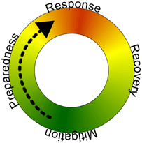
Guyana Strengthens National Multi-Hazard Alert Systems
Guyana has initiated a strategic National Consultative Workshop focused on enhancing Multi-Hazard Early Warning Systems (EWS) across the country. The workshop is part of a broader agenda to establish a fully integrated, people-centred early warning framework that aligns with international standards and addresses the increasing risks associated with climate variability and natural or man-made disasters.
The two-day session brings together national institutions, regional entities, and international organisations to advance technical coordination and multi-sectoral collaboration in disaster risk reduction. It supports the development of a robust system capable of issuing timely alerts and facilitating efficient responses, thereby protecting lives, economic assets, and critical infrastructure.
Key areas of focus include the strengthening of institutional coordination at both national and local levels, the integration of multi-hazard risk assessments into operational planning, and the expansion of communication mechanisms for alert dissemination. Multiple platforms such as digital alerts, SMS, and community radio are under review for broader coverage and accessibility, particularly in vulnerable communities. Capacity building, inclusive planning, and public engagement are central to ensuring that these systems serve all segments of society effectively.
The workshop also seeks to align Guyana’s early warning strategies with global frameworks, including the Sendai Framework for Disaster Risk Reduction, reinforcing commitments to sustainable and climate-resilient development. With contributions from regional and international partners, this initiative represents a significant step forward in building a comprehensive early warning ecosystem capable of addressing hydro-meteorological, geological, and biological hazards.
The outcome of the workshop is expected to inform the operationalisation of a sustainable and adaptive EWS that supports national preparedness and resilience-building efforts.
News and Image Source: Department of Public Information
Guyana hosts National Consultative Workshop to strengthen Multi-Hazard Early Warning Systems for all
The Government of Guyana, through the Civil Defence Commission (CDC), in collaboration with the United Nations Office of Disaster Risk Reduction (UNDRR), today convened a National Consultative Workshop for Multi-Hazard Early Warning for All (EW4ALL). This landmark event brought together national stakeholders, regional partners, and international agencies to enhance Guyana’s national framework for early warning and disaster preparedness.
Other regional and international partners that support the workshop include the Caribbean Disaster Emergency Management Agency (CDEMA), the World Meteorological Organisation (WMO), the International Federation of the Red Cross, and the International Telecommunication Union.

The event opened with welcome remarks from Colonel Nazrul Hussain, DirectorGeneral of the Civil Defence Commission (CDC), followed by opening remarks by Ms. Jean Kamau, UN Resident Coordinator in Guyana. The keynote address was delivered by Dr. Alfred King, Permanent Secretary of the Office of the Prime Minister, his address reaffirmed the government’s commitment to strengthening national resilience and promoting climate adaptation through early warning mechanisms.

The workshop forms part of Guyana’s ongoing efforts to build a comprehensive, people-centred Early Warning System (EWS), aligned with international best practices. The goal is to ensure timely alerts and effective response measures to safeguard lives, livelihoods, and critical infrastructure from the impacts of natural and man-made hazards.
Key themes of the workshop included:
- Strengthening institutional coordination for early warning at the national and local levels
- Integrating multi-hazard risk knowledge, monitoring, and response
- Enhancing communication and dissemination protocols using multiple platforms, including digital alerts, community radios, and SMS
- Empowering vulnerable communities through training and inclusive planning
- Aligning national actions with global frameworks such as the Sendai Framework for Disaster Risk Reduction
The workshop will be held over the next two days and will conclude on Thursday, June 26, 2025. During this time, participants will review Guyana’s Early Warning System Framework and discuss strategies to operationalise an integrated and sustainable early warning system (EWS) that addresses all hazards, including but not limited to hydro-meteorological, geological, and biological risks.

Guyana is currently confronting heightened climate variability and an increase in disaster risks. This workshop represents a crucial advancement in ensuring that all individuals have access to early warning systems and are adequately prepared for potential disasters, emphasising the importance of inclusivity in these efforts.

The Civil Defence Commission extends heartfelt thanks to the UNDRR, CDEMA, the WMO, and all regional and local stakeholders who contributed to the success of this workshop