4th & 5th Generation Hazard Detection Satellites

Multi-hazard Early Warning System Design & Implementation Center (MHEWC): A Global Platform for Multi-Hazard Early Warning Systems (MHEWS)-Supporting the Global South

Created with Sketch.

Comprehensive Research and Development are required to upgrade atmospheric conditions detection and hazard detection in 4th, 5th, and 6th-generation satellites

The United Nations should facilitate an international research, development, deployment, and data-sharing programme for advanced fourth-, fifth-, and sixth-generation satellites dedicated to precision weather monitoring, Earth-system observation, multi-hazard detection, impact forecasting, emergency communication, and early warning.

The proposed programme should not focus on developing a single satellite. It should establish an integrated, multi-orbit “Earth-system intelligence network” comprising:

  • Geostationary weather satellites for continuous monitoring;
  • Polar-orbiting and low-Earth-orbit satellites for global observations;
  • Synthetic Aperture Radar satellites for all-weather, day-and-night imaging;
  • SmallSat and CubeSat constellations for frequent regional revisits;
  • Atmospheric sounding, precipitation-radar, lidar, thermal, hyperspectral, and microwave missions;
  • Satellite communication and direct-to-device warning services;
  • Ground-based observation networks, supercomputing centres, AI platforms, and national warning systems; and
  • Secure data-exchange arrangements linking global, regional, national, and local institutions.

Satellite observations are among the most important inputs to numerical weather prediction, climate monitoring, and environmental analysis. WMO’s Vision for WIGOS in 2040 calls for the evolution of an integrated observing system based on user requirements, international coordination, data accessibility, and complementary space- and surface-based observations. WMO’s Earth-observation satellite programme and WIGOS Vision 2040 provide an appropriate institutional foundation for such an initiative.


a) Important clarification on satellite “generations”

There is no universally accepted scientific or regulatory classification defining all Earth-observation satellites as “fourth,” “fifth,” or “sixth generation.” Existing programmes use their own names—for example, Meteosat Third Generation, Metop Second Generation, GOES-R, GeoXO, Sentinel, and NISAR.

Therefore, the following generational framework should be presented as a proposed capability-based classification for this programme, not as an already established international standard.


Capability

Fourth generation

Fifth generation

Sixth generation

General character

Advanced multi-sensor operational satellites

Cooperative, AI-enabled satellite constellations

Autonomous, cognitive Earth-system observing network

Indicative period

Present–mid-2030s

2030s–2040s

2040s onward

Architecture

Combined GEO, polar and LEO missions

Federated constellations with inter-satellite coordination

Self-organizing swarms and distributed orbital computing

Sensors

High-resolution imagers, hyperspectral sounders, microwave sensors, SAR, lightning and atmospheric-composition instruments

Coordinated multi-sensor payloads, software-defined instruments and adaptive tasking

Reconfigurable payloads, formation-flying sensors and advanced distributed sensing

Artificial intelligence

Mainly ground-based AI, with limited onboard processing

Onboard detection, classification, fusion and tasking

Physics-aware cognitive AI, predictive sensing and distributed learning

Data latency

Minutes to tens of minutes

Targeted sub-five-minute hazard products

Near-real-time, hazard-dependent intelligence

Warning connectivity

Ground-station and conventional broadcast links

Satellite-to-satellite relay and direct-to-device alerts

Resilient, integrated space–air–ground communication mesh

Operational maturity

Operational or emerging

Development and demonstration

Long-term research vision


b) Fourth-generation satellites: integrated precision observation

Fourth-generation satellites should consolidate the best operational and emerging technologies into interoperable, high-resolution multi-hazard observing systems.

Principal characteristics

  • High-frequency geostationary observation

Geostationary satellites should continuously monitor clouds, atmospheric moisture, storms, lightning, aerosols, smoke, dust, volcanic ash, fires, ocean conditions, and land-surface temperature. Regional rapid-scan modes should be capable of observing priority areas at intervals ranging from approximately 30 seconds to several minutes.

  • Hyperspectral atmospheric sounding

Hyperspectral infrared sounders should generate three-dimensional profiles of atmospheric temperature and humidity. These observations can help identify atmospheric instability, dry-air intrusion, moisture convergence, and other conditions associated with:

    • Severe thunderstorms;
    • Mesoscale convective systems;
    • Tropical-cyclone intensification;
    • Extreme rainfall;
    • Heatwaves;
    • Atmospheric rivers; and
    • Rapidly changing weather conditions.
  • Advanced microwave observation

Microwave sounders and imagers should measure atmospheric temperature, humidity, cloud ice, liquid water, precipitation, soil moisture, snow, sea ice, and ocean-surface conditions, including through many cloud-covered environments. Metop-SG’s microwave sounder, for example, is designed to provide temperature and humidity information in both clear and cloudy conditions. EUMETSAT Metop-SG

  • All-weather radar imaging

C, L, S, and X-band Synthetic Aperture Radar missions should provide day-and-night observations through cloud, haze, and rainfall. SAR and interferometric SAR can support:

    • Flood-inundation mapping;
    • Cyclone and ocean-wind analysis;
    • Landslide and slope-deformation monitoring;
    • Earthquake damage assessment;
    • Volcanic deformation monitoring;
    • Coastal erosion analysis;
    • Glacier movement and glacial-lake monitoring;
    • Land subsidence detection; and
    • Damage assessment of dams, roads, bridges, and settlements.

Sentinel-1 demonstrates the value of SAR for flood monitoring because radar can operate through clouds and darkness. ESA Sentinel-1 applications

  • Lightning and severe-convection monitoring

Space-based lightning imagers should continuously detect lightning frequency, location, density, and rapid increases in electrical activity. When combined with cloud-top temperature, water-vapour, radar, and atmospheric-instability observations, lightning data can strengthen the nowcasting of severe thunderstorms.

  • GNSS radio occultation

Constellations should measure how GNSS signals bend while passing through the atmosphere, producing accurate vertical profiles of temperature, moisture, pressure, and ionospheric conditions. Such observations can improve numerical prediction, particularly over oceans and data-sparse tropical regions. UCAR COSMIC-2

  • Initial onboard intelligence

Satellites should begin processing data before downlink by:

    • Removing unusable cloud-covered scenes where appropriate;
    • Detecting fires, floods, smoke plumes, ships, and other anomalies;
    • Compressing and prioritizing emergency data;
    • Creating rapid-look products; and
    • Alerting ground systems that a high-priority observation has occurred.

ESA’s Φsat-2 is already demonstrating onboard AI for Earth-observation applications, including cloud filtering, anomaly detection, maritime-vessel classification, and disaster-response mapping. ESA Φsat-2

c) Fifth-generation satellites: cooperative and AI-enabled sensor networks

Fifth-generation systems should move from individually operated satellites toward interconnected constellations that cooperate as a global sensor network.


Existing systems already demonstrate several building blocks. Meteosat Third Generation combines rapid imagery, lightning detection, and infrared sounding for severe-weather monitoring, while NOAA’s future GeoXO system is intended to expand high-resolution geostationary observations of weather, ocean, atmosphere, and environmental hazards. Meteosat Third Generation and NOAA GeoXO illustrate technologies that could form the operational foundation of the proposed fourth-generation category.

Substantial and sustained investment in research and development is required to upgrade existing satellite systems and develop next-generation satellites capable of detecting, monitoring, characterizing, and tracking atmospheric conditions and emerging hazards with greater accuracy, frequency, resolution, and forecasting lead time.

Advanced satellite constellations should combine geostationary, polar-orbiting, radar, microwave, hyperspectral, and small-satellite technologies to provide continuous observation of the atmosphere, oceans, land surfaces, coastal zones, forests, glaciers, and other hazard-prone environments. These systems should be equipped with high-resolution sensors to monitor cloud formation, atmospheric moisture, temperature profiles, wind circulation, rainfall intensity, lightning activity, surface temperature, soil moisture, vegetation stress, ocean conditions, land deformation, and other environmental anomalies.

Research and development should prioritize satellite capabilities for detecting and monitoring:

  • Rapidly developing thunderstorms and severe convective systems;
  • Tropical cyclones, extreme rainfall, and coastal storm surges;
  • Flash floods, riverine floods, and urban inundation;
  • Droughts, heatwaves, and prolonged dry spells;
  • Wildfires, smoke movement, and extreme surface temperatures;
  • Landslides, ground deformation, and volcanic activity;
  • Snow accumulation, glacier movement, and glacial-lake expansion;
  • Harmful algal blooms, coastal erosion, and marine hazards;
  • Dust storms, air pollution, and hazardous atmospheric emissions; and
  • Compound, cascading, and transboundary climate-related hazards.


Capabilities

a) Multi-orbit coordination

A geostationary satellite detecting rapid cloud development could automatically request:

  • A LEO microwave satellite to observe the storm’s internal structure;
  • A precipitation-radar satellite to measure vertical rainfall characteristics;
  • A SAR satellite to acquire flood-prone areas;
  • A high-resolution optical satellite to collect post-event imagery; and
  • A communication satellite to prepare emergency connectivity for the affected area.

This coordinated tasking would transform separate missions into a responsive multi-hazard observation system.

b) Onboard edge-AI

Fifth-generation satellites should carry radiation-hardened AI accelerators capable of performing:

  • Hazard-anomaly detection;
  • Storm-cell identification and tracking;
  • Fire and smoke recognition;
  • Flood-water segmentation;
  • Volcanic-ash and gas-plume detection;
  • Change detection;
  • Landslide and infrastructure-damage screening;
  • Data-quality assessment;
  • Confidence estimation; and
  • Selection of the most urgent data for immediate transmission.

AI-generated findings should include probability, uncertainty, sensor quality, observation time, model version, and the evidence supporting the classification.

c) Adaptive and event-driven observation

Instead of following only fixed observation schedules, fifth-generation constellations should be able to increase observation frequency over a developing hazard. Once an anomaly is detected, the network could dynamically redirect appropriate satellites, change instrument modes, or expand the observation footprint.

d) Inter-satellite communications

Radio-frequency and optical crosslinks should allow satellites to route urgent information through the constellation to the nearest available ground station. Optical communications can transmit larger data volumes than conventional radio links, although cloud and atmospheric turbulence can affect space-to-ground optical connections. NASA Optical Communications

e) Integration with Earth-system digital twins

Observations should feed continuously into numerical weather prediction, hydrological, oceanographic, wildfire, landslide, atmospheric-chemistry, and impact models. AI would support but not replace physical modeling and scientific validation.

The system should model the full hazard chain, such as:

Tropical cyclone > extreme rainfall > river flooding > landslide > infrastructure failure > population displacement.

f) Direct-to-device warning services

Following authorization by the legally mandated warning authority, satellite systems should be able to transmit geographically targeted alerts directly to compatible phones and low-cost receivers in areas without functioning terrestrial networks. Emerging non-terrestrial networks and satellite-to-phone alerting are already being examined for early-warning applications. ITU satellite communications for early warning

Warnings should use the Common Alerting Protocol and contain:

  • Hazard type;
  • Affected location;
  • Expected time;
  • Severity and certainty;
  • Likely impacts;
  • Protective actions;
  • Expiry time;
  • Authorizing institution; and
  • Links to accessible, multilingual information.

g) Sixth-generation satellites: an autonomous Earth-system intelligence network

Sixth-generation satellites should be treated as a long-term R&D vision. They would constitute a distributed, adaptive, and resilient “planetary nervous system” for observing changes in the atmosphere, ocean, land, cryosphere, biosphere, and built environment.

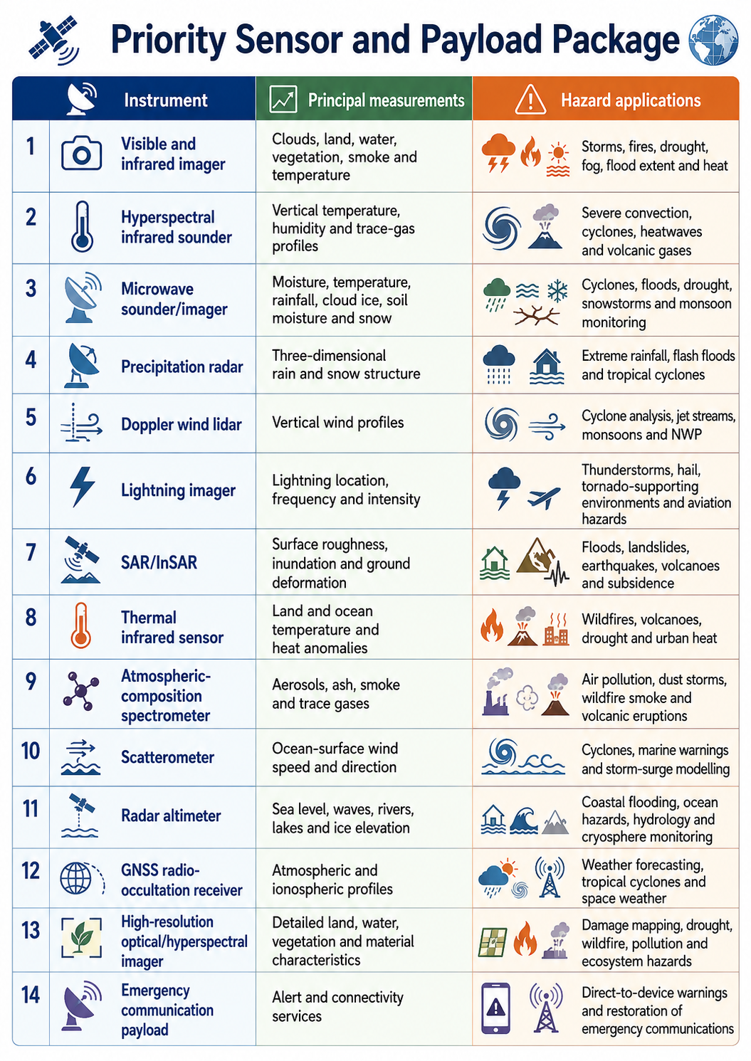
h) Priority sensor and payload package

Instrument

Principal measurements

Hazard applications

Visible and infrared imager

Clouds, land, water, vegetation, smoke and temperature

Storms, fires, drought, fog, flood extent and heat

Hyperspectral infrared sounder

Vertical temperature, humidity and trace-gas profiles

Severe convection, cyclones, heatwaves and volcanic gases

Microwave sounder/imager

Moisture, temperature, rainfall, cloud ice, soil moisture and snow

Cyclones, floods, drought, snowstorms and monsoon monitoring

Precipitation radar

Three-dimensional rain and snow structure

Extreme rainfall, flash floods and tropical cyclones

Doppler wind lidar

Vertical wind profiles

Cyclone analysis, jet streams, monsoons and NWP

Lightning imager

Lightning location, frequency and intensity

Thunderstorms, hail, tornado-supporting environments and aviation hazards

SAR/InSAR

Surface roughness, inundation and ground deformation

Floods, landslides, earthquakes, volcanoes and subsidence

Thermal infrared sensor

Land and ocean temperature and heat anomalies

Wildfires, volcanoes, drought and urban heat

Atmospheric-composition spectrometer

Aerosols, ash, smoke and trace gases

Air pollution, dust storms, wildfire smoke and volcanic eruptions

Scatterometer

Ocean-surface wind speed and direction

Cyclones, marine warnings and storm-surge modelling

Radar altimeter

Sea level, waves, rivers, lakes and ice elevation

Coastal flooding, ocean hazards, hydrology and cryosphere monitoring

GNSS radio-occultation receiver

Atmospheric and ionospheric profiles

Weather forecasting, tropical cyclones and space weather

High-resolution optical/hyperspectral imager

Detailed land, water, vegetation and material characteristics

Damage mapping, drought, wildfire, pollution and ecosystem hazards

Emergency communication payload

Alert and connectivity services

Direct-to-device warnings and restoration of emergency communications

NASA’s Atmosphere Observing System illustrates the future value of combining radar, lidar, microwave, and other instruments to understand the vertical structure of clouds, convection, aerosols, and precipitation. NASA Atmosphere Observing System


Hazard-specific applications and limitations
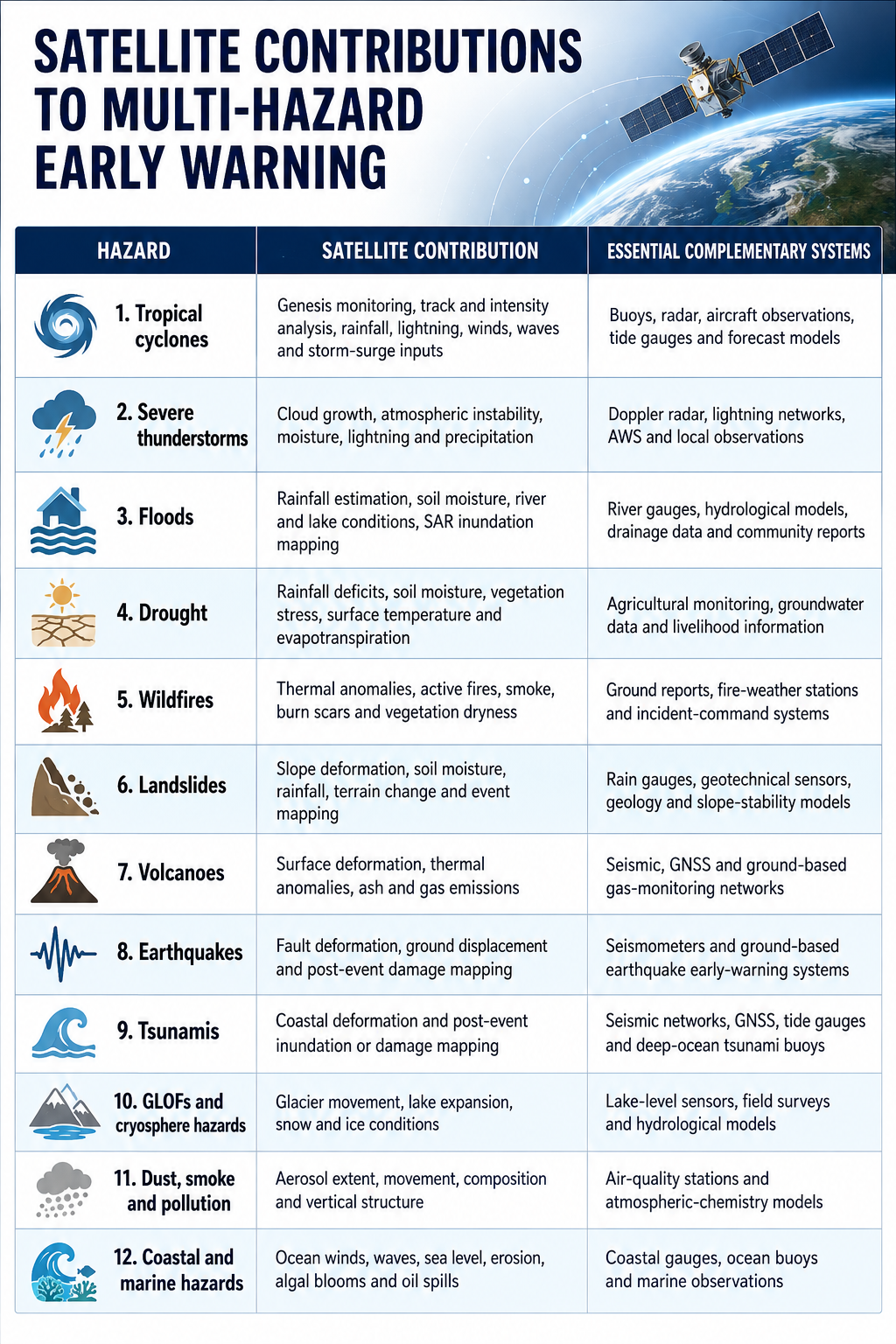
Hazard

Satellite contribution

Essential complementary systems

Tropical cyclones

Genesis monitoring, track and intensity analysis, rainfall, lightning, winds, waves and storm-surge inputs

Buoys, radar, aircraft observations, tide gauges and forecast models

Severe thunderstorms

Cloud growth, atmospheric instability, moisture, lightning and precipitation

Doppler radar, lightning networks, AWS and local observations

Floods

Rainfall estimation, soil moisture, river and lake conditions, SAR inundation mapping

River gauges, hydrological models, drainage data and community reports

Drought

Rainfall deficits, soil moisture, vegetation stress, surface temperature and evapotranspiration

Agricultural monitoring, groundwater data and livelihood information

Wildfires

Thermal anomalies, active fires, smoke, burn scars and vegetation dryness

Ground reports, fire-weather stations and incident-command systems

Landslides

Slope deformation, soil moisture, rainfall, terrain change and event mapping

Rain gauges, geotechnical sensors, geology and slope-stability models

Volcanoes

Surface deformation, thermal anomalies, ash and gas emissions

Seismic, GNSS and ground-based gas-monitoring networks

Earthquakes

Fault deformation, ground displacement and post-event damage mapping

Seismometers and ground-based earthquake early-warning systems

Tsunamis

Coastal deformation and post-event inundation or damage mapping

Seismic networks, GNSS, tide gauges and deep-ocean tsunami buoys

GLOFs and cryosphere hazards

Glacier movement, lake expansion, snow and ice conditions

Lake-level sensors, field surveys and hydrological models

Dust, smoke and pollution

Aerosol extent, movement, composition and vertical structure

Air-quality stations and atmospheric-chemistry models

Coastal and marine hazards

Ocean winds, waves, sea level, erosion, algal blooms and oil spills

Coastal gauges, ocean buoys and marine observations

                        …………………………………………………………………………………………….

Satellite research should also advance artificial intelligence, machine learning, automated anomaly detection, onboard data processing, rapid image interpretation, and real-time hazard classification. Instead of transmitting only raw observations, future satellites should be capable of generating preliminary hazard indicators, detecting unusual environmental changes, prioritizing high-risk areas, and rapidly communicating critical information to forecasting centres and disaster-management authorities.

These satellites must be connected to an integrated observation and forecasting architecture that combines space-based information with weather radar, lightning-detection networks, automated weather stations, hydrological gauges, ocean buoys, seismic instruments, drones, crowdsourced observations, and community-based monitoring systems. Satellite products should also be assimilated into high-resolution numerical weather-prediction models, flood and storm-surge models, wildfire models, landslide-susceptibility systems, and impact-based forecasting platforms.

Research must also address persistent operational limitations, including insufficient spatial resolution, long revisit periods, delayed data transmission, inadequate observation of remote and transboundary areas, weak ground validation, limited interoperability, and unequal access to satellite data. Special attention should be given to the Global South, where limited observation infrastructure and dependence on externally produced satellite products frequently constrain local forecasting, early warning, and emergency decision-making.

A coordinated international research programme should therefore establish common technical standards, open and affordable data-access arrangements, interoperable platforms, shared calibration and validation facilities, cybersecurity safeguards, and regional satellite-data processing centres. It should also support national institutions in developing the technical capacity, computing infrastructure, analytical tools, and skilled personnel required to transform satellite observations into actionable warnings.

The long-term objective should be the establishment of an integrated global satellite-based atmospheric and multi-hazard intelligence system capable of determining:

  • What atmospheric anomaly or hazard is developing;
  • Where and when it is likely to occur;
  • How the hazard may evolve and how severe it could become;
  • Which populations, infrastructure, ecosystems, and economic sectors are exposed;
  • What impacts are likely to occur; and
  • What preventive, anticipatory, preparedness, and emergency actions should be taken before impact.

Such investment would transform satellites from primarily observational platforms into intelligent components of an integrated global early-warning and climate-risk-management system strengthening hazard detection, forecasting, impact assessment, anticipatory action, emergency response, and the protection of lives, livelihoods, infrastructure, and ecosystems.
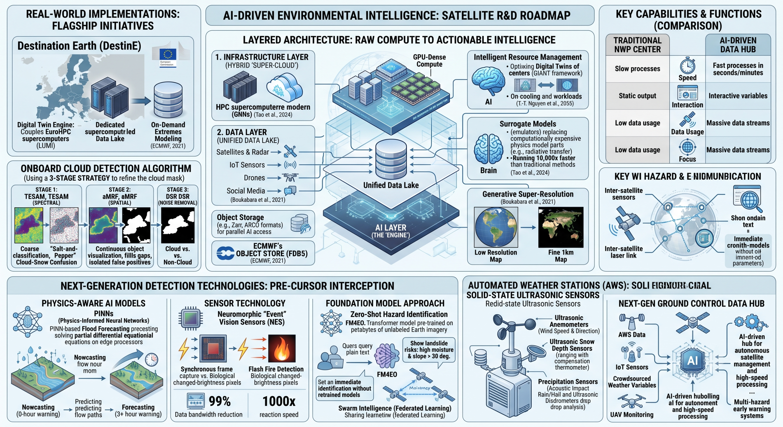
This research proposal aims to design a satellite sensor to acquire and process hyperspectral images directly on the satellite (onboard) to identify clouds before the data are compressed or transmitted to Earth. This is critical because hyperspectral sensors generate massive amounts of data, and transmitting useless cloudy images wastes valuable bandwidth.

The following is a breakdown of the Three-Stage Strategy proposed in the paper, which combines spectral (color/light) and spatial (shape/neighbor) information.

1. The Core Challenge

Standard cloud detection methods often struggle with:

  • Bright Surface Features: Distinguishing white clouds from non-rain-bearing clouds, thunder clouds, ice clouds,  snow, ice, or bright desert sand.

  • Shadowed Clouds: Detecting clouds that are darker due to lighting conditions.

  • Onboard Constraints: Algorithms must be computationally efficient enough to run on the satellite’s limited hardware.

2. The Solution: A 3-Stage Algorithm

The paper introduces a pipeline that progressively refines the cloud mask:

Stage 1: Spectral Processing (TESAM)

  • Method: Threshold Exponential Spectral Angle Map (TESAM).

  • Function: This stage looks at the “fingerprint” (spectral signature) of each pixel. It measures the spectral angle between the pixel’s spectrum and a reference cloud spectrum.

  • Outcome: A “coarse” classification. It identifies most cloud pixels but may produce “salt-and-pepper” noise or confuse bright snow with clouds because it looks at pixels in isolation.

Stage 2: Spatial Processing (aMRF)

  • Method: Adaptive Markov Random Field (aMRF).

  • Function: This stage incorporates spatial context. It operates on the logic that clouds are continuous objects, not scattered random pixels. It looks at the neighbors of a pixel to verify its classification.

  • Outcome: It smoothes the result from Stage 1, filling in gaps within cloud masses and removing isolated false positives (e.g., a single “cloud” pixel in the middle of a forest is likely noise).

Stage 3: Noise Removal (DSR)

  • Method: Dynamic Stochastic Resonance (DSR).

  • Function: A final filtering step designed to remove any remaining stubborn noise or misclassified points that survived the aMRF process. DSR is particularly good at enhancing weak signals (true features) while suppressing noise.

  • Outcome: A clean, binary cloud mask (Cloud vs. Non-Cloud).

3. Key Results & Performance

  • Dataset: The method was validated using Hyperion data (a hyperspectral sensor on the EO-1 satellite).

  • Accuracy: The paper reports an average overall accuracy of 96.28%.

  • Comparison: It reportedly outperformed conventional onboard methods (like simple thresholding) and was robust enough to distinguish between snow and clouds, a notorious difficulty in remote sensing.

4. Why This Matters

  • Bandwidth Savings: By flagging cloudy pixels onboard, the satellite can choose to either compress those regions heavily (lossy compression) or skip transmitting them entirely, saving data costs.

  • Autonomy: It enables satellites to make decisions without waiting for instructions from ground stations.

AI-Driven Ground Infrastructure:

  • Develop an AI-driven Ground Control Data Hub capable of autonomous satellite management and high-speed data processing.
  • Rapid Hazard Detection Innovation:
  • Innovate new AI-powered rapid detection technologies to identify and analyze hazards in real-time, significantly reducing warning lead times.
  • AI-enabled hazard detection and multi-hazard early warning systems, integrating AI-driven reconnaissance surface observations, IoT sensor-based, and acquisition of crowdsourced weather variables, hazard onset detection, event situational awareness, and hazard hotspot tracking.
  • IoT sensor, AI, UAV, and drone–driven monitoring systems for climate change and multi-hazard exposure, risk, and vulnerability assessment of climate-vulnerable productive sectors, including agriculture, livestock, fisheries, water resources, environment, forests, ecology and biodiversity, and human and food security.
  • IoT sensor, AI, UAV, and drone–enabled rapid post-disaster loss, damage, and needs assessment (RPDNA) to support timely response, recovery planning, and evidence-based decision-making.

This R&D proposal outlines a suite of Next-Generation Detection Technologies designed to shift the operational paradigm from “Rapid Response” to “Pre-Cursor Interception.”

The objective is to identify the subtle chemical, thermal, and physical signals that precede a disaster, using AI to convert these signals into warnings before the event physically manifests.

  1. The Core Innovation: “Physics-Aware” AI Models

Current AI detects what is visible (e.g., smoke). The new standard is Physics-Informed Neural Networks (PINNs), which embed physical laws (fluid dynamics, thermodynamics) into the AI’s learning process.

  • Technology: PINN-based Flood Forecasting.
    • How it works: Instead of just looking at rising water levels, the AI solves partial differential equations (like the Shallow Water Equations) in real-time on the satellite’s edge processor.
    • Capability: It predicts exactly where the flood wave will hit 3 hours in advance based on upstream topography and soil saturation, rather than waiting for the water to arrive.
    • Impact: Moves from “Nowcasting” (0-hour warning) to true “Forecasting” (3+ hour warning) using only onboard data.
  1. Sensor Technology: Neuromorphic “Event” Vision

This is a radical departure from standard “frame-based” cameras (which record 30 frames per second, creating massive data).

  • Technology: Neuromorphic Event Sensors (NES).
    • Concept: These sensors work like the human eye. They do not capture images; they only capture changes in brightness at the pixel level, measured in microseconds.
    • Application: Lightning & Flash Fire Detection.
      • Standard cameras miss the “ignition spark” between frames.
      • NES captures the initial micro-second chemical flash of an explosion or the exact propagation path of a lightning leader (Lightning Mapping).
    • Benefit: Reduces data bandwidth by 99% (since static backgrounds are ignored) while increasing reaction speed by 1000x.
  1. The “Foundation Model” Approach

We are moving away from training one AI for fires and another for floods. The new approach uses Multimodal Earth Observation Foundation Models (FM4EO).

  • Technology: Zero-Shot Hazard Identification.
    • Architecture: A massive Transformer model (similar to GPT-4 but for satellite data) pre-trained on petabytes of unlabeled Earth imagery (Optical, SAR, Thermal).
    • Innovation: You can query the satellite in plain text: “Show me areas with high soil moisture AND slope > 30 degrees.” The AI instantly identifies landslide risks without needing a specific “landslide training dataset.”
    • Agility: Allows the system to adapt to entirely new types of hazards (e.g., a new type of chemical spill) in minutes without retraining.
  1. “Swarm Intelligence” (Federated Learning)

This technology allows the constellation to “learn” as a collective organism.

  • Scenario: Satellite A detects a new wildfire pattern it hasn’t seen before.
  • Process: Instead of sending the image to Earth to retrain the model (slow), Satellite A updates its own weights and transmits only the learned parameters (a few kilobytes) to Satellite B, C, and D via inter-satellite laser links.
  • Result: The entire constellation “learns” to spot the new fire signature within one orbit cycle (90 minutes), creating a self-improving global defense grid.

Summary of Proposed R&D Technologies

Technology

Detection Target

Warning Lead Time Improvement

PINNs (Physics-Informed AI)

Flash Floods, Tsunamis

+3 to 6 Hours (Predicts flow path)

Neuromorphic Sensors

Lightning,  Grid Arcs

Real-Time (Microsecond latency)

Hyperspectral + AI

Lightning, Thunderstorm, Torrential rain, flash floods, mudslide, landslide 

Days/Weeks (Detects chemical stress)

InSAR + Edge AI

Volcanic Eruption, Structural Collapse

Days (Detects mm-level ground deformation)

  • 4th Generation (Operational Now/Deploying): Defined by “Multispectral + Lightning.” These satellites moved us from seeing “cloud tops” to seeing “cloud physics” and lightning activity in real-time.1 They operate on a “collect everything, process on ground” model.
  • 5th Generation (2030+ / In Development): Defined by “Hyperspectral + AI Autonomy.” These systems will move from observing hazards to characterizing them chemically and physically in orbit. They will operate on a “process in space, alert instantly” model.
  1. 4th Generation: The “High-Definition” Era

Current operational standard (e.g., NOAA GOES-R Series, EUMETSAT MTG, Himawari-8/9).

Core Capabilities

  • Advanced Baseline Imagers (ABI): Jumped from 5 spectral bands to 16+ bands. This allows differentiation between snow, fog, ash, and smoke.
  • Geostationary Lightning Mappers (GLM): The first-ever continuous detection of total lightning (in-cloud and cloud-to-ground) from space.2 This is the primary tool for predicting tornado formation lead times (increasing them from ~10 to ~20 minutes).
  • Rapid Scan Mode: Can “stare” at a single mesoscale event (like a hurricane eye) every 30 to 60 seconds, providing movie-like smoothness to track rapid intensification.

Limitations

  • “Dumb” Pipelines: The satellite transmits all raw data to Earth. If a sensor sees a clear blue ocean for 12 hours, it wastes bandwidth transmitting terabytes of “nothing.”
  • Vertical Blindness: They see the tops of clouds excellently but struggle to resolve temperature/moisture layers inside the atmosphere accurately (vertical resolution is coarse).
  1. 5th Generation: The “Intelligent Mesh” Era

Future standard (e.g., NOAA GeoXO, ESA Scout Missions, Commercial AI Constellations).

Core Innovations

  • Hyperspectral Sounding (The “CAT Scan” of the Sky):
    • Instead of 16 bands, 5th Gen sensors (like the upcoming GXS on GeoXO) use 1,500+ channels.
    • Impact: It creates a 3D volume of the atmosphere, slicing it into 1km vertical layers. It can see humidity pooling at specific altitudes before clouds even form, predicting storm initiation hours earlier than radar.
  • Onboard AI (Edge Computing):
    • Smart Downlink: The satellite uses AI to “watch” its own feed. If it detects smoke, it prioritizes that packet. If it sees nothing, it compresses the data or discards it.
    • Latency: < 1 minute (satellite-to-user).
  • Composition & Chemistry:
    • Dedicated sensors (UV-Visible spectrometers) to measure Nitrogen Dioxide (NO2) and Formaldehyde hourly. This allows tracking of invisible toxic plumes from chemical fires or urban pollution in real-time.

Comparison Matrix: 4th vs. 5th Generation

Feature

4th Generation (Current)

5th Generation (Future 2030+)

Primary Sensor

Multispectral Imager (~16 bands)

Hyperspectral Sounder (>1000 bands)

Hazard Detection

Visible Smoke, Ash, Lightning

Invisible Gas Leaks, Pre-Convective Moisture

Data Model

“Bent Pipe” (Relay raw data to ground)

Edge AI (Process data in orbit)

Resolution

500m – 2km

30m – 100m (via LEO/GEO integration)

Ocean Capability

Basic Surface Temperature

Ocean Color (Red Tide/Algae toxicity detection)

Example Missions

GOES-16/17/18, Meteosat Third Gen (MTG)

NOAA GeoXO, Pixxel Fireflies, ESA CHIME

  1. The Strategic Leap: “Tip-and-Cue” Architecture

The defining operational change in 5th Generation systems is the integration of orbits.

  • 4th Gen approach: A GEO satellite sees a fire hotspot. Analysts on the ground see it 15 minutes later and manually order a LEO satellite to take a picture next time it passes (hours later).
  • 5th Gen approach:
    1. GEO Sentinel (36,000km): The “Overwatch” satellite detects a thermal anomaly (fire start).
    2. Autonomous Handshake: It instantly sends a laser signal to a passing LEO Swarm (500km) satellite.
    3. LEO Zoom: The LEO satellite slews its camera, activates its Hyperspectral Mode, and captures a 5m resolution image of the fire front.
    4. Direct Alert: The LEO satellite processes the fire boundary and broadcasts it directly to first responders’ tablets via 5G/6G, bypassing the main ground station entirely..

Ultrasonic sensors have revolutionized automated weather stations (AWS)

Ultrasonic sensors have revolutionized automated weather stations (AWS) by replacing traditional moving parts (like spinning cups and vanes) with “solid-state” technology. This makes them significantly more durable and capable of measuring in harsh conditions where mechanical sensors might freeze or jam. 

These sensors primarily cover three meteorological applications: Wind, Snow Depth, and Precipitation.

  1. Ultrasonic Anemometers (Wind Speed & Direction)

This is the most common application. Unlike mechanical anemometers that use cups for speed and a vane for direction, ultrasonic anemometers use sound pulses to measure the wind.

  • How it Works (Time-of-Flight): The sensor typically has 3 or 4 arms (transducers) facing each other. It sends ultrasonic pulses between them.
    • With the wind: The sound pulse travels faster to the receiver.
    • Against the wind: The sound pulse travels slower.
    • Calculation: By measuring the exact time difference (microseconds) between the pulses in all directions, the onboard processor calculates both the wind speed and the 360° wind direction simultaneously.
  1. Ultrasonic Snow Depth Sensors

These are essential for hydrology and avalanche forecasting. They work similarly to a bat’s echolocation or a car’s backup sensor but are calibrated for the specific acoustic properties of snow.

  • How it Works (Ranging): The sensor is mounted on a crossarm looking down at the ground. It fires a high-frequency sound pulse (ping) downward.
    • The Echo: The pulse bounces off the snow surface and returns to the sensor.
    • The Distance: The time it takes for the echo to return is converted into distance.
    • Compensation: Since the speed of sound changes with air temperature, these sensors almost always have a built-in thermometer to correct the reading; otherwise, a cold night could be mistaken for a change in snow depth.
  1. Precipitation Sensors (Rain & Hail)

There are two main “acoustic” technologies for rain, often confused but distinct:

  • Acoustic Impact Sensors (Passive): These are common in compact weather stations. A polished metal or plastic dome acts as a “drum.” A piezoelectric sensor inside listens to the sound of drops hitting the dome. It distinguishes between the heavy “thud” of hail, the “tap” of rain, and background noise, calculating intensity based on impact energy.
  • Ultrasonic Disdrometers (Active): These are high-end research instruments. They create a “curtain” of ultrasonic waves (or laser light in optical versions). As drops fall through the curtain, they scatter the waves. By analyzing the Doppler shift (frequency change) of the scattered signal, the sensor can determine the size and fall speed of every single raindrop, distinguishing drizzle from heavy rain or snow.
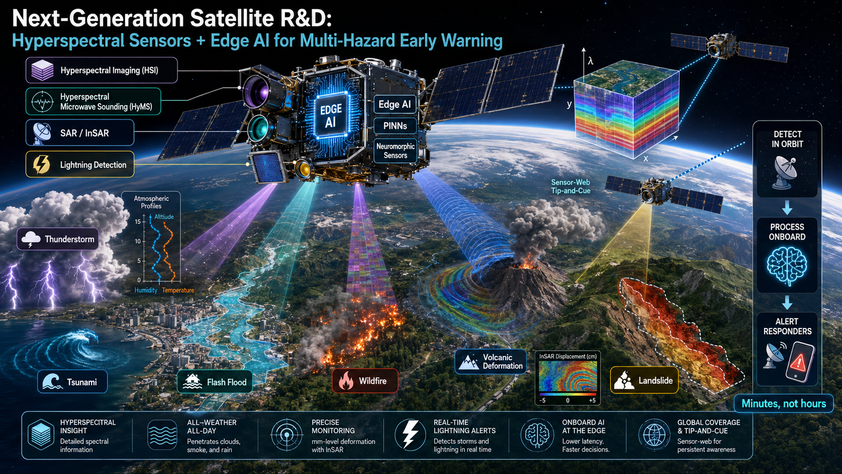
  • Next-Generation Satellite R&D:  Conduct intensive Research and Development (R&D) on the latest generation of satellites integrated with Artificial Intelligence (AI) and advanced Hyperspectral sensors for precise weather monitoring and multi-hazard detection.
 

Advance AI-Enabled Satellite Research for Precision Weather Monitoring and Multi-Hazard Detection

Conduct intensive research and development to design, upgrade, and deploy the latest generation of Earth-observation satellites integrated with artificial intelligence, machine learning, advanced hyperspectral imaging, microwave sensing, synthetic aperture radar, thermal infrared sensors, lightning mappers, and atmospheric profiling technologies. These satellites should enable continuous, high-resolution, and near-real-time monitoring of atmospheric, terrestrial, oceanic, coastal, and cryospheric conditions.

AI-enabled onboard processing should allow satellites to detect environmental anomalies, classify emerging hazards, track their development, estimate their likely intensity and direction, and rapidly transmit priority information to meteorological agencies, disaster-management authorities, Emergency Operations Centres, and early-warning platforms. The system should strengthen the detection and monitoring of severe thunderstorms, tropical cyclones, torrential rainfall, flash floods, storm surges, droughts, heatwaves, wildfires, landslides, volcanic activity, glacier instability, harmful atmospheric emissions, and other compound or cascading hazards.

Advanced hyperspectral sensors should be developed to capture detailed information across hundreds of spectral bands, allowing scientists to identify subtle changes in atmospheric composition, cloud properties, surface temperature, soil moisture, vegetation health, water quality, wildfire conditions, land degradation, and hazardous emissions that conventional satellite sensors may not adequately distinguish.

Priority research areas should include:

  • High-resolution atmospheric temperature, moisture, wind, and cloud profiling;
  • Rapid detection of convective storms and extreme rainfall systems;
  • Automated identification of unusual atmospheric and surface anomalies;
  • AI-based hazard classification, tracking, forecasting, and impact estimation;
  • Onboard data processing to reduce warning-generation time;
  • Integration of geostationary, polar-orbiting, radar, hyperspectral, and small-satellite constellations;
  • Near-real-time data assimilation into numerical weather-prediction and hazard models;
  • Detection of compound, cascading, and transboundary hazards;
  • Ground validation through radar, weather stations, hydrological gauges, drones, and community observations;
  • Open data standards and interoperability with national and regional early-warning systems; and
  • Affordable access to satellite products, technology, computing infrastructure, and technical expertise for Global South countries.

The ultimate goal should be to establish an intelligent, satellite-based global weather and multi-hazard monitoring system capable of determining what hazard is developing, where and when it may occur, how severe it could become, who and what may be affected, and what anticipatory actions should be taken before impact.

Research and Development on AI-Integrated, Hyperspectral Satellite Systems for Precision Weather Monitoring and Multi-Hazard Detection

A coordinated, long-term Research and Development programme should be established to design, test, validate, launch, and operationalize the latest generation of Earth-observation and meteorological satellites equipped with Artificial Intelligence, hyperspectral sensing, edge computing, and autonomous mission-management capabilities. The programme should transform satellites from passive data-collection platforms into intelligent components of an integrated planetary climate-risk intelligence and multi-hazard early-warning network.

The proposed R&D programme should combine geostationary, low-Earth-orbit, polar-orbiting, and small-satellite constellations to provide continuous monitoring of the atmosphere, oceans, land surface, cryosphere, ecosystems, and geophysical processes. It should integrate hyperspectral infrared sounding, hyperspectral optical imaging, emerging hyperspectral microwave sensing, Synthetic Aperture Radar, thermal imaging, lightning detection, atmospheric-composition monitoring, Global Navigation Satellite System observations, and other advanced instruments.

AI should be embedded both onboard satellites and within ground-processing systems to accelerate data interpretation, detect hazardous anomalies, prioritize critical observations, reduce transmission delays, improve weather and hazard forecasting, and generate decision-ready information for National Meteorological and Hydrological Services, disaster-management authorities, Emergency Operations Centres, humanitarian organizations, infrastructure operators, and exposed communities.

1. Strategic purpose

The principal purpose of the R&D programme should be to develop an integrated satellite-based capability that can answer six critical early-warning questions:

  1. What hazardous event is developing?
  2. Where will it occur?
  3. When will it begin, intensify, and end?
  4. How severe is it likely to become?
  5. Who and what will be exposed or affected?
  6. What preventive or anticipatory actions should be taken before impact?

Current satellite systems generate enormous volumes of environmental data, but significant gaps remain in temporal resolution, spatial resolution, vertical atmospheric profiling, all-weather observation, data-processing speed, interoperability, and last-mile operational use. The proposed R&D programme should address these limitations by linking satellite observations directly with forecasting models, risk databases, exposure information, impact models, warning systems, and anticipatory-action protocols.

2. Core R&D objectives

The programme should pursue the following objectives:

  • Develop high-resolution satellite instruments capable of observing rapidly evolving atmospheric, oceanic, hydrological, terrestrial, and geological conditions.
  • Improve the detection of pre-hazard signals before dangerous events fully develop.
  • Enable near-real-time or real-time processing of satellite data through onboard AI and edge computing.
  • Develop multi-sensor satellite constellations capable of observing the same event from complementary orbital and spectral perspectives.
  • Fuse satellite observations with radar, weather-station, hydrological, oceanographic, seismic, drone, crowdsourced, and Internet-of-Things data.
  • Improve the initialization and continuous updating of Numerical Weather Prediction, hydrological, ocean, wildfire, landslide, and atmospheric-dispersion models.
  • Develop AI models for hazard identification, tracking, forecasting, classification, and impact estimation.
  • Reduce the time between satellite observation, hazard identification, official warning issuance, and protective action.
  • Make high-quality satellite data and derived services more accessible to Least Developed Countries, Small Island Developing States, and other high-risk Global South countries.
  • Establish common standards for calibration, validation, interoperability, cybersecurity, responsible AI, and operational warning use.

3. Advanced hyperspectral sensing research

Hyperspectral instruments measure hundreds or thousands of narrow, contiguous spectral channels. This allows the satellite to distinguish subtle atmospheric, surface, vegetation, water, mineral, chemical, and thermal characteristics that conventional multispectral instruments may not detect.

However, “hyperspectral” is not a single sensing capability. The R&D programme should distinguish among three complementary forms.

3.1 Hyperspectral infrared atmospheric sounding

Hyperspectral infrared sounders should be developed to produce frequent three-dimensional profiles of:

  • atmospheric temperature;
  • water vapour and relative humidity;
  • atmospheric stability;
  • temperature inversions;
  • cloud properties;
  • ozone and selected trace gases;
  • surface and cloud-top temperature;
  • atmospheric motion and moisture transport; and
  • pre-convective environmental conditions.

These observations are particularly important for identifying atmospheric instability, moisture convergence, dry-air intrusion, rapidly rising convective potential, and other conditions preceding severe thunderstorms, extreme rainfall, tropical cyclones, and damaging winds.

NOAA’s planned GeoXO Sounder illustrates this technical direction: it is designed to provide real-time information on the vertical distribution of atmospheric temperature, moisture, and winds. Its hyperspectral infrared observations are intended to improve severe-weather forecasting and Numerical Weather Prediction. NOAA GeoXO Infrared Sounding

3.2 Hyperspectral microwave sounding

Research should be intensified on miniaturized hyperspectral microwave sounders capable of producing high-spectral-resolution observations under cloudy and many precipitation-affected conditions.

Unlike visible and infrared instruments, microwave observations can penetrate many cloud layers. This makes them particularly valuable for observing:

  • temperature and humidity profiles beneath clouds;
  • precipitation structure;
  • cloud liquid water and ice;
  • tropical-cyclone internal structure;
  • atmospheric conditions over oceans;
  • surface and near-surface moisture;
  • snow and ice properties; and
  • all-weather thermodynamic conditions.

Recent NOAA-supported research has examined the fusion of hyperspectral microwave and hyperspectral infrared observations using machine learning, showing the potential to improve characterization of the atmosphere under diverse surface and weather conditions. NOAA next-generation hyperspectral microwave–infrared research

Hyperspectral microwave sensing remains less operationally mature than conventional microwave sounding and hyperspectral infrared sounding. The R&D programme should therefore prioritize instrument miniaturization, calibration, antenna design, radiometric sensitivity, channel selection, radio-frequency interference mitigation, and flight demonstration.

3.3 Visible-to-shortwave-infrared hyperspectral imaging

Visible, near-infrared, and shortwave-infrared imaging spectrometers should be developed for detailed surface and environmental monitoring, including:

  • vegetation condition and crop stress;
  • drought impacts;
  • vegetation water content and wildfire fuel conditions;
  • burned-area severity;
  • soil properties and land degradation;
  • coastal and inland water quality;
  • harmful algal blooms;
  • sediment and pollution plumes;
  • snow, ice, and surface-material characteristics;
  • mineral dust-source composition;
  • methane and selected greenhouse-gas plumes; and
  • ecosystem degradation and biodiversity-related indicators.

ESA’s CHIME mission concept, for example, uses more than 200 spectral bands between 400 and 2,500 nanometres to characterize vegetation, soils, and surface materials. ESA CHIME mission overview

NASA’s EMIT imaging spectrometer has demonstrated the value of imaging spectroscopy for mapping mineral-dust sources and identifying methane plumes through their spectral signatures. NASA EMIT mission

These surface-imaging instruments should complement, rather than be confused with, hyperspectral atmospheric sounders. Optical hyperspectral imagery alone cannot provide continuous, all-weather monitoring of rapidly developing storms because clouds obscure the surface and satellite revisit times may be insufficient.

4. Artificial Intelligence and onboard edge computing

AI integration should be undertaken at two interconnected levels: onboard the satellite and within the ground-processing and forecasting system.

4.1 Onboard AI

Onboard processors should analyse data immediately after observation, without waiting for the complete dataset to be transmitted to a ground station. Research priorities should include:

  • automatic cloud and image-quality screening;
  • detection of fires, smoke, floods, volcanic ash, dust storms, oil spills, algal blooms, methane plumes, and rapid surface changes;
  • identification of unusual atmospheric or surface anomalies;
  • automatic classification of observed features;
  • change detection against previous satellite passes;
  • intelligent compression of large hyperspectral datasets;
  • prioritization of hazard-relevant data for immediate transmission;
  • adaptive selection of spectral channels;
  • autonomous retasking of satellite instruments;
  • event-triggered high-resolution observation;
  • inter-satellite communication and collaborative observation; and
  • generation of preliminary alert packets with location, time, confidence, and event characteristics.

ESA’s Φ-sat-1 demonstrated onboard AI processing of hyperspectral imagery, including cloud detection before data transmission. This shows the potential to reduce unnecessary downlink and prioritize useful observations. ESA Artificial Intelligence for Earth observation

4.2 Ground-based AI

Ground systems should apply more computationally intensive models to:

  • calibrate and correct satellite observations;
  • reconstruct missing or corrupted data;
  • fuse observations from multiple satellites and ground networks;
  • retrieve atmospheric and surface variables;
  • assimilate observations into weather and hazard models;
  • track convective cells, cyclones, flood extents, fires, ash clouds, and pollution plumes;
  • estimate event probability, intensity, duration, and trajectory;
  • forecast compound and cascading hazards;
  • estimate exposed populations, infrastructure, crops, ecosystems, and services;
  • generate impact-based forecast products;
  • quantify uncertainty and confidence;
  • translate complex scientific data into operational dashboards; and
  • support authoritative warning decisions.

The AI architecture should combine physical models with machine learning. Purely data-driven systems may generate apparently precise results that violate physical laws or perform poorly under unprecedented extreme conditions. Physics-informed and hybrid AI should therefore be a major R&D priority.

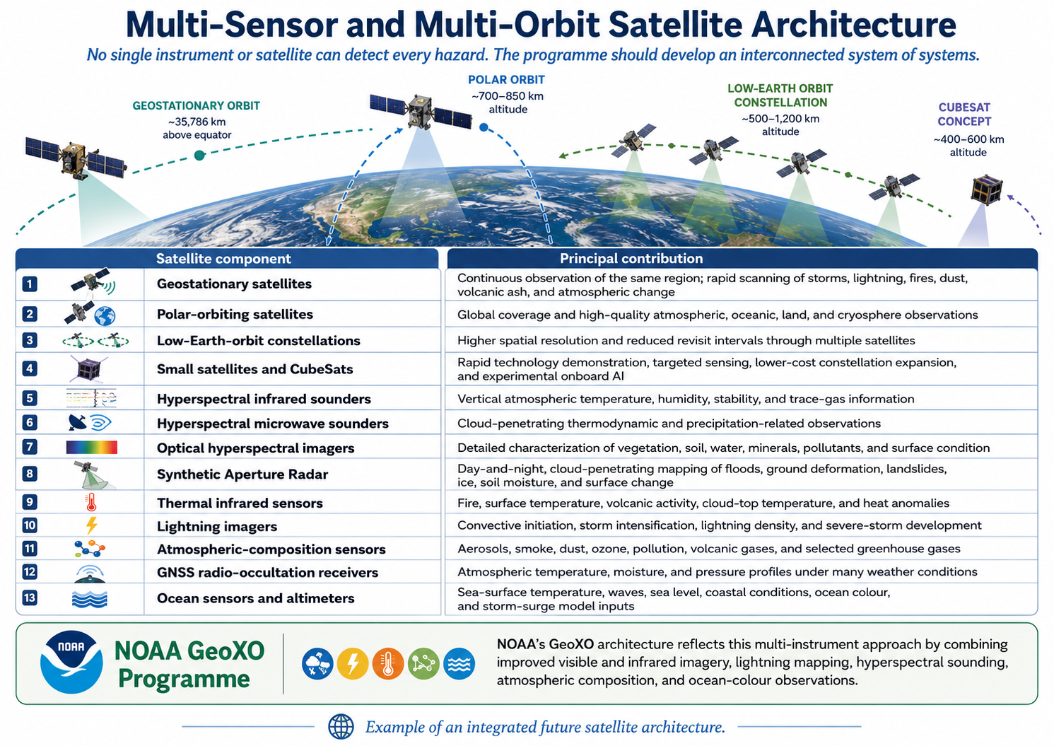
5. Multi-sensor and multi-orbit satellite architecture

No single instrument or satellite can detect every hazard. The programme should develop an interconnected “system of systems.”

Satellite componentPrincipal contribution
Geostationary satellitesContinuous observation of the same region; rapid scanning of storms, lightning, fires, dust, volcanic ash, and atmospheric change
Polar-orbiting satellitesGlobal coverage and high-quality atmospheric, oceanic, land, and cryosphere observations
Low-Earth-orbit constellationsHigher spatial resolution and reduced revisit intervals through multiple satellites
Small satellites and CubeSatsRapid technology demonstration, targeted sensing, lower-cost constellation expansion, and experimental onboard AI
Hyperspectral infrared soundersVertical atmospheric temperature, humidity, stability, and trace-gas information
Hyperspectral microwave soundersCloud-penetrating thermodynamic and precipitation-related observations
Optical hyperspectral imagersDetailed characterization of vegetation, soil, water, minerals, pollutants, and surface condition
Synthetic Aperture RadarDay-and-night, cloud-penetrating mapping of floods, ground deformation, landslides, ice, soil moisture, and surface change
Thermal infrared sensorsFire, surface temperature, volcanic activity, cloud-top temperature, and heat anomalies
Lightning imagersConvective initiation, storm intensification, lightning density, and severe-storm development
Atmospheric-composition sensorsAerosols, smoke, dust, ozone, pollution, volcanic gases, and selected greenhouse gases
GNSS radio-occultation receiversAtmospheric temperature, moisture, and pressure profiles under many weather conditions
Ocean sensors and altimetersSea-surface temperature, waves, sea level, coastal conditions, ocean colour, and storm-surge model inputs

NOAA’s GeoXO architecture reflects this multi-instrument approach by combining improved visible and infrared imagery, lightning mapping, hyperspectral sounding, atmospheric composition, and ocean-colour observations. NOAA GeoXO programme

6. Priority multi-hazard applications

Severe thunderstorms and extreme rainfall

The system should detect atmospheric instability, moisture convergence, rapidly cooling cloud tops, overshooting cloud structures, lightning jumps, convective initiation, storm-cell growth, hail potential, and probable damaging winds.

AI should integrate hyperspectral atmospheric profiles, visible and infrared imagery, microwave observations, lightning data, Doppler weather radar, and surface observations to predict storm initiation, movement, severity, and impact.

Tropical cyclones and coastal hazards

Satellite R&D should improve monitoring of:

  • cyclone genesis;
  • central dense overcast and eye formation;
  • internal rainband and eyewall structure;
  • intensity change and rapid intensification;
  • ocean heat and sea-surface temperature;
  • upper-level atmospheric conditions;
  • rainfall distribution;
  • coastal inundation and storm-surge model inputs; and
  • post-impact flood and damage extent.

Floods and flash floods

Satellite observations should be integrated with radar rainfall, soil moisture, catchment conditions, river levels, terrain, drainage networks, land cover, and exposure databases. SAR satellites are especially important for flood mapping through cloud cover.

AI should produce rapidly updated maps of:

  • inundated areas;
  • flood depth where modelling permits;
  • affected settlements and roads;
  • isolated communities;
  • damaged cropland;
  • critical infrastructure exposure; and
  • probable downstream flood progression.

Drought, agricultural stress, and food insecurity

Hyperspectral, thermal, microwave, and radar observations should support the monitoring of vegetation health, crop stress, evapotranspiration, soil moisture, water availability, vegetation water content, land degradation, and abnormal seasonal development.

The resulting information should be connected with food-security monitoring and forecast-based anticipatory-action systems.

Wildfire

AI-enabled satellites should detect heat anomalies and active fire fronts, estimate fire radiative power, map fuel condition, track smoke, identify burned areas, and support forecasts of fire spread and air-quality impacts.

Landslides and ground instability

Satellite rainfall, soil-moisture, terrain, land-cover, and InSAR ground-deformation measurements should be fused to identify unstable slopes and probable landslide initiation zones. Satellite observations should be complemented by ground instruments because many slope failures develop at scales smaller than routine satellite products can resolve.

Earthquakes, volcanoes, and geological hazards

SAR and InSAR should be used to measure surface deformation before and after earthquakes and volcanic activity. Thermal and atmospheric-composition sensors can detect volcanic heat and gas emissions, while hyperspectral sensors can characterize ash and some gas plumes.

NASA–ISRO’s NISAR mission demonstrates the value of dual-frequency SAR for measuring centimetre-scale surface change and supporting research on earthquakes, volcanoes, landslides, ecosystems, ice, and other Earth-surface processes. NASA NISAR mission

Air pollution and atmospheric hazards

Hyperspectral and atmospheric-composition instruments should monitor smoke, dust, volcanic ash, aerosols, ozone, nitrogen dioxide, carbon monoxide, methane, and other relevant constituents. AI-based trajectory models should forecast where hazardous plumes will travel and which populations may be exposed.

Coastal, marine, and water-quality hazards

Hyperspectral ocean-colour and thermal observations should support monitoring of harmful algal blooms, coral and ecosystem stress, sediment plumes, coastal pollution, oil spills, thermal anomalies, and changing coastal water conditions.

7. Recommended R&D work packages

The programme could be organized through ten interconnected work packages:

  1. Mission requirements and hazard-use cases: Define priority hazards, decision needs, spatial resolution, revisit frequency, latency, accuracy, and warning lead-time requirements.
  2. Hyperspectral instrument development: Advance infrared, microwave, thermal, and optical imaging spectrometers, including detector sensitivity, calibration, spectral stability, and miniaturization.
  3. Space-qualified AI processors: Develop radiation-tolerant, energy-efficient processors capable of operating advanced AI models onboard satellites.
  4. Autonomous constellation management: Test event-triggered observation, satellite-to-satellite communication, collaborative sensing, and “tip-and-cue” operations.
  5. Multi-source data fusion: Combine satellite, radar, weather-station, hydrological, oceanographic, seismic, UAV, IoT, and community-observation data.
  6. Forecasting and data assimilation: Assimilate hyperspectral radiances and retrieved products into convection-permitting weather models and coupled atmospheric–hydrological–ocean models.
  7. Hazard and impact algorithms: Develop AI models for hazard detection, event tracking, probability estimation, exposure analysis, impact forecasting, and loss-and-damage estimation.
  8. Calibration, validation, and uncertainty: Establish global reference sites, field campaigns, inter-satellite comparisons, ground-truth networks, and uncertainty-reporting standards.
  9. Operational early-warning integration: Connect satellite-derived outputs with NMHS forecasting platforms, EOCs, Common Alerting Protocol systems, mobile warning channels, and Early Action Protocols.
  10. Capacity, access, and technology transfer: Establish regional processing hubs, cloud platforms, training programmes, open-data services, and technical support for developing countries.

Institutional architecture

A proposed UN Global Space, Earth Observation, and Early Warning Consortium could coordinate the programme.

Responsibilities could include:

  • WMO: observation requirements, calibration, meteorological standards, data exchange, forecast integration, and coordination with WIGOS;
  • UNOOSA and UN-SPIDER: space cooperation, technical advisory support, disaster applications, and capacity development;
  • ITU: radio spectrum, satellite communications, non-terrestrial networks, CAP-based dissemination, and emergency connectivity;
  • UNDRR: risk knowledge, MHEWS policy, Sendai Framework alignment, and monitoring;
  • UNESCO and IOC: ocean, tsunami, hydrological, and scientific cooperation;
  • National meteorological and hydrological services: forecasting and authoritative technical analysis;
  • National disaster-management authorities: warning authorization, coordination, preparedness, and response;
  • Space agencies: satellite design, launch, operation, calibration, and mission continuity;
  • Universities and research institutions: sensor, AI, modelling, and validation research;
  • Private sector: commercial data, launch services, cloud infrastructure, communication systems, and innovation; and
  • Communities and civil society: locally observed impacts, warning feedback, accessibility, and last-mile verification.

UN-SPIDER already works to improve the use of space-based information across disaster-risk reduction and emergency response, especially through knowledge sharing and capacity development. UNOOSA UN-SPIDER

8. Indicative performance goals

Mission-specific requirements should be established through scientific testing, but the R&D programme should work toward:

  • hazard-product delivery within minutes of observation for rapidly developing events;
  • rapid scanning at intervals suitable for convective storms and other fast-changing hazards;
  • kilometre- to sub-kilometre-scale observations where technically feasible;
  • high vertical resolution for atmospheric temperature and moisture profiles;
  • increased observation beneath cloud through microwave and radar sensing;
  • improved revisit frequency through coordinated constellations;
  • automated identification and prioritization of emergency observations;
  • quantified uncertainty for every AI-generated product;
  • compatibility with operational forecasting and warning standards; and
  • secure, interoperable, and machine-readable data exchange.

9. Validation, governance, and responsible AI

AI-generated satellite information should not automatically be treated as an authoritative public warning. Nationally mandated authorities, particularly NMHSs and disaster-management agencies, must retain responsibility for validation and warning issuance.

The R&D programme should establish:

  • traceable satellite-calibration procedures;
  • independent validation of AI algorithms;
  • tests across different climates, terrains, seasons, and hazard regimes;
  • bias assessments for data-scarce regions;
  • explainable hazard-detection outputs;
  • confidence and uncertainty information;
  • human oversight for critical decisions;
  • protection against cyber intrusion and data manipulation;
  • version control and audit trails for operational algorithms;
  • safeguards against dual-use misuse;
  • continuity arrangements when satellites, communications, or AI systems fail; and
  • preservation of scientifically valid source data for reprocessing and verification.

WMO recognizes that AI can strengthen forecasts and early warnings by processing diverse information rapidly and identifying complex patterns, while operational use still requires reliable observations, scientific verification, institutional capacity, and authoritative warning arrangements. WMO Artificial Intelligence

10. Phased implementation roadmap

Phase I: Research and system design

  • Conduct user-needs and hazard-monitoring assessments.
  • Identify critical observation gaps.
  • Define sensor, orbit, latency, resolution, and interoperability requirements.
  • Develop instrument and AI-processing prototypes.
  • Build simulated satellite datasets and digital test environments.
  • Select pilot hazards and geographic regions.

Phase II: Technology demonstration

  • Test sensors using aircraft, drones, high-altitude platforms, and CubeSats.
  • Validate onboard AI and data-compression algorithms.
  • Conduct multi-sensor field campaigns.
  • Test data assimilation and impact-forecasting models.
  • Establish ground stations and cloud-processing systems.
  • Demonstrate rapid transmission of hazard alerts.

Phase III: Pilot constellation and operational validation

  • Launch demonstration satellites or hosted payloads.
  • Integrate satellite observations with national and regional forecasting systems.
  • Conduct real-time operational trials.
  • Compare results with radar and ground observations.
  • Run simulations and multi-agency emergency exercises.
  • Evaluate warning accuracy, latency, lead time, and decision usefulness.

Phase IV: Operational deployment and global scaling

  • Deploy complementary geostationary and low-Earth-orbit capabilities.
  • Establish regional satellite data and climate-risk intelligence centres.
  • Provide open or affordable access to participating countries.
  • Integrate products with EOCs, national risk platforms, and warning systems.
  • Maintain continuous algorithm improvement, recalibration, and independent evaluation.

Proposed consolidated formulation

Conduct intensive Research and Development on the latest generation of AI-integrated Earth-observation and meteorological satellites equipped with hyperspectral infrared, optical and emerging microwave sensors, advanced radar, thermal imaging, lightning detection, atmospheric-composition instruments, and onboard edge-computing capabilities. The programme should develop an interconnected constellation of geostationary, polar-orbiting, low-Earth-orbit, and small satellites capable of continuously observing atmospheric instability, extreme weather, oceanic processes, hydrological conditions, land-surface change, ecosystem stress, and geophysical hazards. Artificial Intelligence should enable onboard data screening, anomaly detection, autonomous retasking, intelligent compression, rapid hazard classification, multi-sensor data fusion, and prioritized transmission of time-critical information. Satellite-derived observations should be assimilated into weather, hydrological, ocean, wildfire, landslide, and impact-forecasting models and connected directly with national multi-hazard early-warning systems, Emergency Operations Centres, Common Alerting Protocol platforms, and anticipatory-action mechanisms. The ultimate objective should be to create a reliable, interoperable, scientifically validated, and globally accessible satellite-based climate-risk intelligence system that provides precise, timely, impact-oriented, and actionable information for protecting lives, livelihoods, infrastructure, ecosystems, and economies.


This Research and Development (R&D) brief consolidates the state-of-the-art in next-generation satellite systems, focusing on the convergence of Hyperspectral Imaging (HSI), Hyperspectral Microwave Sounding (HyMS), and Edge Artificial Intelligence (Edge AI).

Executive Summary: The Shift to “Insight at the Edge”

 The traditional satellite paradigm—”store massive raw data and downlink for processing”—is obsolete for real-time disaster management.1 The latest R&D focuses on Smart Satellites: platforms that use hyperspectral sensors to see the “chemical fingerprint” of Earth and onboard AI to interpret that data in orbit.2 This reduces decision latency from hours to minutes, critical for dynamic hazards like wildfires and flash floods.

Technology

Detection Target

Warning Lead Time Improvement

Active Microwave (Radar)

1) SAR (Synthetic Aperture Radar): Creates ultra-high resolution images (seeing through night and clouds). Used for spy satellites and earthquake monitoring (InSAR).

2) Altimeters: Shoot a pulse straight down to measure sea level height (for El Niño and currents).

3) Scatterometers: Measure the roughness of the ocean to calculate wind speed/direction.


Onboard Hyperspectral and Spatial RDT/Thunder Cloud Detection Remote Sensing imaging sensor


To address your query regarding Onboard Hyperspectral and Spatial RDT (Rapid Developing Thunderstorm) / Thunder Cloud Detection, this refers to a cutting-edge class of remote sensing instruments and processing architectures designed to detect severe weather before and during its formation.

This technology typically involves the fusion of two distinct sensor types (Hyperspectral Sounders and High-Resolution Imagers) and increasingly leverages onboard processing (Edge AI) to reduce alert latency.


Lightning detection sensor

Lightning detection sensors are devices designed to detect the electromagnetic or optical signals emitted by lightning discharges. Because lightning is a high-energy event, it emits signals across multiple spectrums—visible light, radio waves (RF), and sound—allowing for different detection methods depending on the required range and accuracy.


Cloud Detection in Hyperspectral Images With Atmospheric

The phrase “With Atmospheric” in the context of Hyperspectral Imaging (HSI) typically refers to using atmospheric absorption bands to detect clouds, or dealing with atmospheric correction as a prerequisite for identifying ground features.

Hyperspectral sensors (like Hyperion, PRISMA, or EnMAP) measure hundreds of bands, allowing them to utilize these specific “atmospheric” channels:


PINNs (Physics-Informed AI)

PINNs (Physics-Informed Neural Networks) are a breakthrough class of AI models that solve complex scientific problems by combining deep learning with physical laws (like fluid dynamics or thermodynamics).

Flash Floods, Tsunamis

+3 to 6 Hours (Predicts flow path)

Neuromorphic Sensors

Neuromorphic Sensors (often called Event-Based Sensors or Silicon Retinas) are a completely different class of camera technology. Instead of capturing images frame-by-frame like a standard video camera, they function biologically—mimicking the human eye and brain.

For your specific interests in Lightning Detection and Remote Sensing, these are arguably the most promising emerging technology because they solve the two biggest problems in those fields. Standard cameras are synchronous: they capture the entire scene (every pixel) 30 or 60 times a second, even if nothing is moving. This creates massive amounts of redundant data (static background) and misses anything that happens between the frames. Lightning,  Grid Arcs

Real-Time (Microsecond latency)

Hyperspectral + AI

Combining Hyperspectral Imaging (HSI) with Artificial Intelligence (AI) is the standard for modern remote sensing because it solves the fundamental problem of HSI: The “Curse of Dimensionality.”

A hyperspectral sensor produces a “Data Cube” ($x, y, \lambda$) with hundreds of bands. This data is too massive and complex for traditional statistical methods (like Maximum Likelihood) to handle efficiently. AI, to detect Lightning, Thunderstorm, Torrential rain, flash floods, mudslide, landslide .

Days/Weeks (Detects chemical stress)

InSAR + Edge AI

InSAR + Edge AI represents a paradigm shift in satellite radar interferometry. Traditionally, InSAR (Interferometric Synthetic Aperture Radar) is a “downlink-first, process-later” technology because the raw data is massive and the processing (phase unwrapping) is computationally expensive.

Edge AI flips this model: instead of sending terabytes of raw raw data to Earth, the satellite uses onboard AI accelerators to process the interferograms in orbit and downlink only the displacement alerts.

 Volcanic Eruption, Structural Collapse

Days (Detects mm-level ground deformation)

  1. Core Technology: Next-Gen Sensor Architectures

Research distinguishes between two distinct classes of hyperspectral sensors required for this dual mandate (Weather vs. Hazards).

  1. Optical Hyperspectral (For Surface Hazards)
  • Technology: These sensors capture light in hundreds of narrow, contiguous spectral bands (Visible to Shortwave Infrared, 400–2500 nm).4
  • R&D Focus: Miniaturization of cooling systems for SWIR (Shortwave Infrared) sensors to fit on CubeSats.
  • Capability: Unlike standard cameras that see “green forest,” HSI sees “stressed vegetation with low moisture content,” predicting fire risk before a spark.5
  • Key Commercial Player: Pixxel (launching “Fireflies” constellation in 2025, 5m resolution).6
  1. Hyperspectral Microwave Sounders (For Precise Weather)
  • Technology: Unlike optical sensors, these operate in the microwave spectrum and can “see through” clouds.7
  • R&D Focus: HyMS (Hyperspectral Microwave Sounding). Traditional sounders sample ~20 channels. HyMS samples hundreds, creating a vertical 3D profile of atmospheric temperature and moisture.
  • Capability: Delivers granular data on humidity and precipitation structures within storm cells, drastically improving Numerical Weather Prediction (NWP) accuracy.
  • Key Player: Spire Global (deploying HyMS on nanosatellites).8
  1. AI Integration: The “Edge Computing” Revolution

The primary bottleneck in HSI is data volume (a hyperspectral image is 100x larger than a standard photo). R&D is currently focused on Onboard AI Processing to solve this.

AI Function

Traditional Method

Next-Gen Onboard AI

R&D Benefit

Cloud Detection

Downlink all images; discard cloudy ones on ground.

CloudScout (CNNs): Satellite detects clouds instantly and deletes useless data.

Saves 70-80% bandwidth/storage.

Event Detection

Human analyst reviews images hours later.

Anomaly Detection: Satellite autonomously identifies fire/flood and triggers an alert.

Latency reduced to <15 mins.

Calibration

Periodic ground-based calibration.

AI Auto-Calibration: Deep learning models correct sensor noise/drift in real-time.

Higher data fidelity without downtime.


Critical R&D Vector: Development of “Lightweight Neural Networks” (quantized models) that can run on low-power, radiation-hardened chips (e.g., specialized FPGAs or VPUs) in space.9

  1. Key Missions & R&D Programs (2025-2028)

Commercial Sector (Agile/High-Res)

  • Pixxel (Fireflies):
    • Status: Launching 2025.
    • Innovation: 5-meter resolution with 250+ spectral bands.10 This resolution is fine enough to detect specific chemical leaks or individual tree health.11
  • Spire x NOAA (HyMS):
    • Status: Operational testing.
    • Innovation: Proving that hyperspectral microwave sounders can fit on 16U nanosatellites, democratizing high-end weather data.12

Agency Sector (High-Fidelity/Global)

  • ESA CHIME (Copernicus Hyperspectral Imaging Mission):
    • Launch: ~2028.
    • Focus: Global routine mapping for agriculture and food security.13 It will provide the “gold standard” calibration for commercial constellations.
  • NASA SBG (Surface Biology and Geology):
    • Launch: Late 2020s.
    • Focus: Multi-platform approach combining VSWIR (Visible-SWIR) and Thermal Infrared to track evapotranspiration and volcanic activity.
  1. R&D Roadmap: The “Sensor Web” Concept

Future R&D is moving toward Trusted Autonomous Satellite Operations (TASO).14

  1. Inter-Satellite Links (ISL): A “Firefly” satellite detects a wildfire ignition point.
  2. Autonomous Tip-and-Cue: It instantly messages a high-res optical satellite or SAR (Radar) satellite via ISL to “stare” at that coordinate.
  3. Direct-to-Handset Alerting: The AI processes the fire boundary and sends a vector polygon directly to ground responders’ mobile devices, bypassing central processing hubs.15

2) AI-Driven Ground Infrastructure: Develop an AI-driven Ground Control Data Hub capable of autonomous satellite management and high-speed data processing.

This Research and Development (R&D) plan outlines the architecture for an AI-Driven Ground Control Data Hub (AI-GCDH). Unlike traditional ground stations that passively receive data, this facility functions as an autonomous “active agent,” capable of making real-time decisions to pilot satellite constellations and process petabytes of data with near-zero latency.

Executive Summary: The “Lights-Out” Facility

The AI-GCDH operates on a “human-on-the-loop” (rather than in-the-loop) basis. Its core function is to close the intelligence cycle—detecting an event in fresh data and immediately re-tasking satellites to monitor it—without human intervention.

  1. Architecture: The “Tri-Core” System

The Hub is divided into three highly integrated autonomous cores.

Core A: The Autonomous Commander (Satellite Management)

This system replaces manual mission planning with Deep Reinforcement Learning (DRL) agents.

  • Dynamic Scheduling: instead of rigid 24-hour schedules, the DRL agent continuously re-optimizes the fleet’s tasks every minute based on cloud cover forecasts, battery health, and priority requests.
  • Predictive Health (IdM): An “Isolation and Mitigation” AI analyzes telemetry streams (voltage, temperature, spin rates) to predict component failures days before they occur, automatically scheduling maintenance modes.
  • Automated Collision Avoidance: The system ingests debris tracking data (e.g., from USSPACECOM) and autonomously calculates and uploads maneuver burns to avoid collisions.

Core B: The Hyper-Speed Refinery (Data Processing)

This core handles the massive influx of data (optical/SAR) using a Packet-Level AI approach.

  • Ingest: Data is received via Optical Ground Links (Laser Comm) at 100+ Gbps.
  • FPGA Pre-Processing: Before data hits a server, Field-Programmable Gate Arrays (FPGAs) perform “wire-speed” cleaning—stripping out corrupted packets and decrypting signals in nanoseconds.
  • Visual Processing Pipeline:
    • Level 0 to 1 (Radiometric Correction): Automated by GPU clusters.
    • Level 1 to 2 (Feature Extraction): A bank of Vision Transformers (ViTs) identifies objects (ships, fires, buildings) and creates vector maps instantly.
    • Super-Resolution: Generative Adversarial Networks (GANs) upscale lower-resolution imagery (e.g., 3m to 50cm) to fill coverage gaps.

Core C: The “Tip-and-Cue” Loop (Feedback)

This is the Hub’s defining R&D innovation. It connects Core A and Core B.

  • Trigger: Core B detects a “High Confidence Event” (e.g., a new wildfire started at lat/long X).
  • Action: It sends a priority flag to Core A.
  • Response: Core A calculates which satellite is nearest, interrupts its current low-priority task, and commands it to slew its sensors to the fire’s coordinates for a high-res scan.
  • Latency: Total time from detection to new command upload: < 30 seconds.
  1. Hardware Infrastructure Specification

To support this autonomy, the physical ground station requires a specialized “Hybrid Compute” design.

Component

Specification

Purpose

Edge Compute Units

NVIDIA DGX Stations (or equivalent)

Located directly at the antenna site to process data before it hits the cloud (reducing backhaul costs).

Storage Fabric

NVMe-over-Fabrics (NVMe-oF)

Provides the millions of IOPS (Input/Output Operations Per Second) needed to feed the GPUs without bottling.

Antenna Network

Phased Array Flat Panels

Unlike moving dishes, these electronic steering antennas can track multiple satellites simultaneously, tripling throughput.

  1. R&D Challenges & Solutions
  • Challenge: Data Deluge. Laser links will downlink more data than can be stored cost-effectively.
    • Solution: “Smart Discard” Policies. The AI is trained to recognize and immediately delete “empty” data (open ocean, heavy cloud cover) before it is archived, saving 40-60% of storage costs.
  • Challenge: Security. An autonomous system is a high-value target for cyberattacks.
    • Solution: AI-driven Cyber Defense. A separate “Watchdog AI” monitors internal network traffic for anomalous patterns (e.g., a sudden, unauthorized change in satellite tasking logic) and can “air-gap” the system instantly.
  1. Implementation Roadmap
  1. Phase 1 (Month 1-6): Build the “Digital Twin.” Create a full simulation of the constellation and ground hub to train the Reinforcement Learning scheduler without risking real assets.
  2. Phase 2 (Month 7-12): Deploy the “Refinery” (Core B) on historical data to benchmark processing speeds against current manual methods.
  3. Phase 3 (Month 13+): Live test with a single “pathfinder” satellite to validate the autonomous Tip-and-Cue loop.
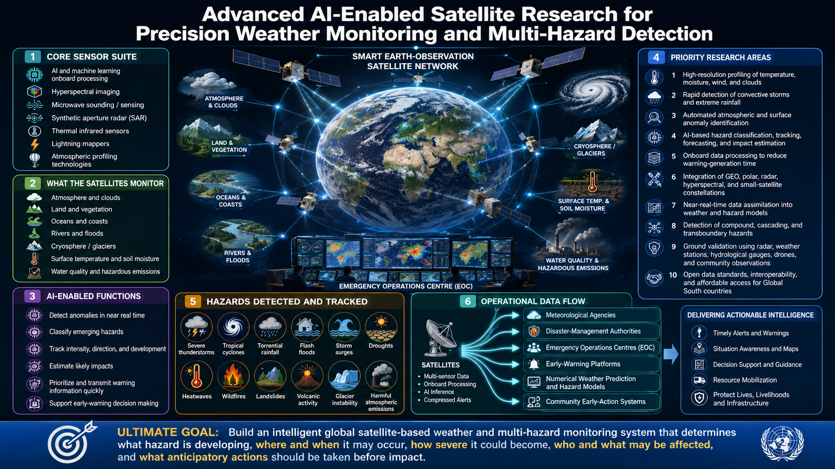
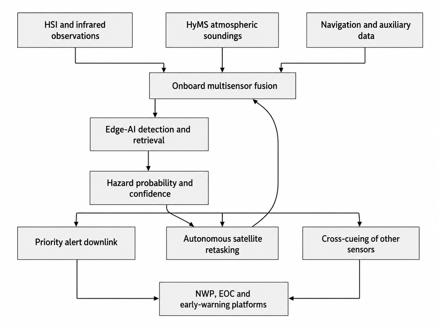
3) Rapid Hazard Detection Innovation:  Innovate new AI-powered rapid detection technologies to identify and analyze hazards in real-time, significantly reducing warning lead times.

This Research and Development (R&D) plan outlines the architecture for an AI-Driven Ground Control Data Hub (AI-GCDH). Unlike traditional ground stations that passively receive data, this facility functions as an autonomous “active agent,” capable of making real-time decisions to pilot satellite constellations and process petabytes of data with near-zero latency.

Executive Summary: The “Lights-Out” Facility

The AI-GCDH operates on a “human-on-the-loop” (rather than in-the-loop) basis. Its core function is to close the intelligence cycle—detecting an event in fresh data and immediately re-tasking satellites to monitor it—without human intervention.

1. Architecture: The “Tri-Core” System

The Hub is divided into three highly integrated autonomous cores.

Core A: The Autonomous Commander (Satellite Management)

This system replaces manual mission planning with Deep Reinforcement Learning (DRL) agents.

  • Dynamic Scheduling: instead of rigid 24-hour schedules, the DRL agent continuously re-optimizes the fleet’s tasks every minute based on cloud cover forecasts, battery health, and priority requests.
  • Predictive Health (IdM): An “Isolation and Mitigation” AI analyzes telemetry streams (voltage, temperature, spin rates) to predict component failures days before they occur, automatically scheduling maintenance modes.
  • Automated Collision Avoidance: The system ingests debris tracking data (e.g., from USSPACECOM) and autonomously calculates and uploads maneuver burns to avoid collisions.

Core B: The Hyper-Speed Refinery (Data Processing)

This core handles the massive influx of data (optical/SAR) using a Packet-Level AI approach.

  • Ingest: Data is received via Optical Ground Links (Laser Comm) at 100+ Gbps.
  • FPGA Pre-Processing: Before data hits a server, Field-Programmable Gate Arrays (FPGAs) perform “wire-speed” cleaning—stripping out corrupted packets and decrypting signals in nanoseconds.
  • Visual Processing Pipeline:
    • Level 0 to 1 (Radiometric Correction): Automated by GPU clusters.
    • Level 1 to 2 (Feature Extraction): A bank of Vision Transformers (ViTs) identifies objects (ships, fires, buildings) and creates vector maps instantly.
    • Super-Resolution: Generative Adversarial Networks (GANs) upscale lower-resolution imagery (e.g., 3m to 50cm) to fill coverage gaps.

Core C: The “Tip-and-Cue” Loop (Feedback)

This is the Hub’s defining R&D innovation. It connects Core A and Core B.

  • Trigger: Core B detects a “High Confidence Event” (e.g., a new wildfire started at lat/long X).
  • Action: It sends a priority flag to Core A.
  • Response: Core A calculates which satellite is nearest, interrupts its current low-priority task, and commands it to slew its sensors to the fire’s coordinates for a high-res scan.
  • Latency: Total time from detection to new command upload: < 30 seconds.

2. Hardware Infrastructure Specification

To support this autonomy, the physical ground station requires a specialized “Hybrid Compute” design.

ComponentSpecificationPurpose
Edge Compute UnitsNVIDIA DGX Stations (or equivalent)Located directly at the antenna site to process data before it hits the cloud (reducing backhaul costs).
Storage FabricNVMe-over-Fabrics (NVMe-oF)Provides the millions of IOPS (Input/Output Operations Per Second) needed to feed the GPUs without bottling.
Antenna NetworkPhased Array Flat PanelsUnlike moving dishes, these electronic steering antennas can track multiple satellites simultaneously, tripling throughput.

3. R&D Challenges & Solutions

  • Challenge:Data Deluge. Laser links will downlink more data than can be stored cost-effectively.
    • Solution: “Smart Discard” Policies. The AI is trained to recognize and immediately delete “empty” data (open ocean, heavy cloud cover) before it is archived, saving 40-60% of storage costs.
  • Challenge:Security. An autonomous system is a high-value target for cyberattacks.
    • Solution: AI-driven Cyber Defense. A separate “Watchdog AI” monitors internal network traffic for anomalous patterns (e.g., a sudden, unauthorized change in satellite tasking logic) and can “air-gap” the system instantly.

4. Implementation Roadmap

  1. Phase 1 (Month 1-6): Build the “Digital Twin.” Create a full simulation of the constellation and ground hub to train the Reinforcement Learning scheduler without risking real assets.
  2. Phase 2 (Month 7-12): Deploy the “Refinery” (Core B) on historical data to benchmark processing speeds against current manual methods.
  3. Phase 3 (Month 13+): Live test with a single “pathfinder” satellite to validate the autonomous Tip-and-Cue loop.
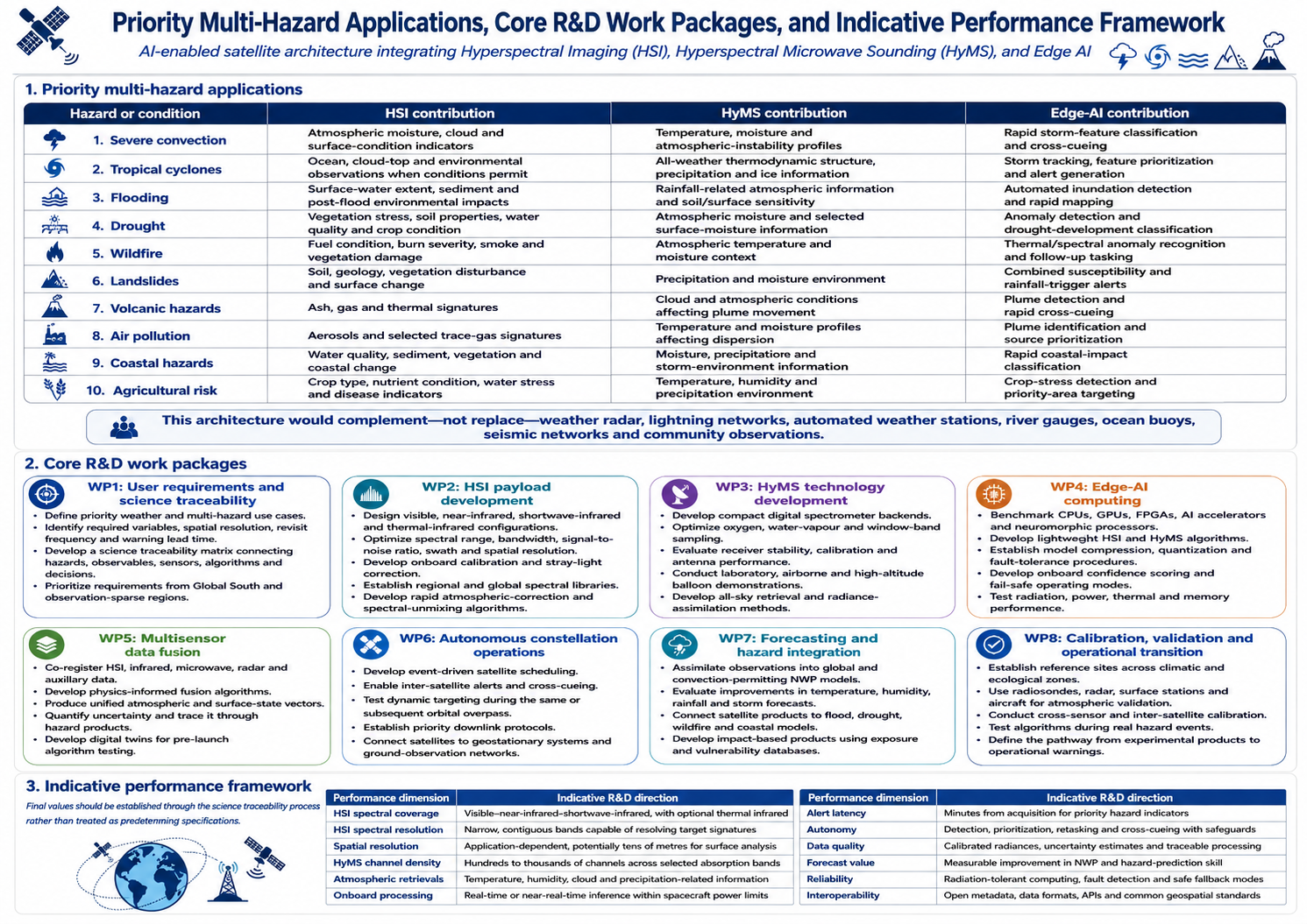
Advanced AI-Enabled Satellite Research for Precision Weather Monitoring and Multi-Hazard Detection

Conduct intensive research and development to design, upgrade, and deploy the latest generation of Earth-observation satellites integrated with artificial intelligence, machine learning, advanced hyperspectral imaging, microwave sensing, synthetic aperture radar, thermal infrared sensors, lightning mappers, and atmospheric profiling technologies. These satellites should enable continuous, high-resolution, and near-real-time monitoring of atmospheric, terrestrial, oceanic, coastal, and cryospheric conditions.

AI-enabled onboard processing should allow satellites to detect environmental anomalies, classify emerging hazards, track their development, estimate their likely intensity and direction, and rapidly transmit priority information to meteorological agencies, disaster-management authorities, Emergency Operations Centres, and early-warning platforms. The system should strengthen the detection and monitoring of severe thunderstorms, tropical cyclones, torrential rainfall, flash floods, storm surges, droughts, heatwaves, wildfires, landslides, volcanic activity, glacier instability, harmful atmospheric emissions, and other compound or cascading hazards.

Advanced hyperspectral sensors should be developed to capture detailed information across hundreds of spectral bands, allowing scientists to identify subtle changes in atmospheric composition, cloud properties, surface temperature, soil moisture, vegetation health, water quality, wildfire conditions, land degradation, and hazardous emissions that conventional satellite sensors may not adequately distinguish.

Priority research areas should include:

  • High-resolution atmospheric temperature, moisture, wind, and cloud profiling;
  • Rapid detection of convective storms and extreme rainfall systems;
  • Automated identification of unusual atmospheric and surface anomalies;
  • AI-based hazard classification, tracking, forecasting, and impact estimation;
  • Onboard data processing to reduce warning-generation time;
  • Integration of geostationary, polar-orbiting, radar, hyperspectral, and small-satellite constellations;
  • Near-real-time data assimilation into numerical weather-prediction and hazard models;
  • Detection of compound, cascading, and transboundary hazards;
  • Ground validation through radar, weather stations, hydrological gauges, drones, and community observations;
  • Open data standards and interoperability with national and regional early-warning systems; and
  • Affordable access to satellite products, technology, computing infrastructure, and technical expertise for Global South countries.

The ultimate goal should be to establish an intelligent, satellite-based global weather and multi-hazard monitoring system capable of determining what hazard is developing, where and when it may occur, how severe it could become, who and what may be affected, and what anticipatory actions should be taken before impact.


Research and Development (R&D) brief consolidates the state-of-the-art in next-generation satellite systems, focusing on the convergence of Hyperspectral Imaging (HSI), Hyperspectral Microwave Sounding (HyMS), and Edge Artificial Intelligence (Edge AI).”


1. Executive summary

This Research and Development brief consolidates the state of the art in next-generation Earth-observation and meteorological satellite systems, focusing on the convergence of three transformative technologies:

  1. Hyperspectral Imaging  HSI for detecting subtle spectral signatures associated with atmospheric composition, vegetation stress, soil and water conditions, fires, pollution and surface change;
  2. Hyperspectral Microwave Sounding—HyMS for retrieving vertically resolved atmospheric temperature and moisture information, including under many cloudy conditions; and
  3. Edge Artificial Intelligence—Edge AI for processing satellite observations onboard, detecting anomalies, generating rapid alerts and autonomously prioritizing observations and data transmission.

Together, these technologies could move satellite systems beyond conventional Earth observation toward an intelligent, adaptive and near-real-time atmospheric and multi-hazard risk-intelligence architecture. Such a system would support severe-weather monitoring, numerical weather prediction, impact-based forecasting, anticipatory action, disaster preparedness and climate-risk management.

However, the three technologies are at different levels of maturity. Spaceborne hyperspectral imaging and hyperspectral infrared sounding are already operational or scientifically demonstrated. Onboard AI has been demonstrated through missions such as ESA’s Φsat series. Hyperspectral microwave sounding, involving hundreds or thousands of finely resolved microwave channels, remains an emerging technology requiring further airborne, spaceborne and operational validation.

2. R&D rationale

Existing satellite systems provide indispensable observations for global weather forecasting and environmental monitoring, but important limitations remain:

  • Conventional multispectral imagers may not distinguish materials or atmospheric constituents with similar broadband signatures.
  • Optical and reflected-light hyperspectral sensors are affected by clouds and generally require daylight.
  • Hyperspectral infrared sounders provide detailed atmospheric profiles but cannot fully observe the atmosphere beneath thick clouds.
  • Conventional microwave sounders can penetrate many cloud systems but use relatively few, comparatively broad spectral channels.
  • Low-Earth-orbit satellites may observe a location only during scheduled overpasses, limiting continuous monitoring.
  • Large raw-data volumes can delay downlinking and operational processing.
  • Centralized ground processing can create latency between satellite acquisition and warning delivery.
  • Current satellites generally operate as independent platforms rather than coordinated, self-tasking observation networks.
  • Many Global South countries lack direct access to high-resolution satellite products, processing infrastructure and locally validated algorithms.

Satellite soundings are among the most important observation sources used by numerical weather-prediction systems, particularly where ground observations are sparse. WMO emphasizes the central role of space-based observations in weather analysis, forecasting, advisories and warnings. WMO Space-Based Observing System

The proposed R&D programme should therefore investigate how HSI, HyMS and Edge AI can be integrated into a coordinated satellite architecture that improves observational precision, atmospheric profiling, hazard recognition and information-delivery speed.

3. Technology pillar 1: Hyperspectral Imaging

3.1 What HSI provides

Hyperspectral imaging measures reflected or emitted energy across tens to hundreds of narrow, contiguous spectral channels. Whereas a conventional multispectral imager may record a limited number of broad bands, HSI produces a detailed spectrum for every observed pixel.

This enables the identification of materials, environmental conditions and physical or chemical processes through their distinctive spectral signatures. Potential variables include:

  • Vegetation type, health, water content and nutrient stress;
  • Soil mineralogy, moisture, salinity and organic-carbon conditions;
  • Surface-water quality, turbidity, chlorophyll and algal blooms;
  • Wildfire burn severity and vegetation recovery;
  • Atmospheric aerosols, dust and selected trace gases;
  • Methane and carbon-dioxide emission plumes;
  • Volcanic ash and selected hazardous emissions;
  • Snow, ice and glacier-surface properties;
  • Coastal pollution, sediment movement and ecosystem degradation; and
  • Post-disaster debris, damaged vegetation and surface-material changes.

Operational and demonstration missions illustrate the technology’s increasing maturity. ESA’s planned CHIME mission is designed for hyperspectral observation over approximately 400–2,500 nm, with spectral sampling of 10 nm or better and a ground resolution of approximately 30 metres. ESA CHIME mission specifications

3.2 Atmospheric hyperspectral infrared sounding

Surface-oriented HSI should be distinguished from hyperspectral infrared atmospheric sounding. Instruments such as NOAA’s Cross-track Infrared Sounder measure finely resolved infrared radiances from which atmospheric temperature, moisture and trace-gas profiles can be retrieved.

CrIS provides observations across more than 2,200 channels and supports the measurement of temperature, water vapour and trace gases such as carbon dioxide, methane, ozone, sulphur dioxide and carbon monoxide. NOAA CrIS overview

Hyperspectral infrared sounding is particularly valuable for:

  • Identifying atmospheric instability before storm development;
  • Monitoring temperature and moisture profiles;
  • Detecting dry-air intrusion and moisture transport;
  • Estimating atmospheric stability indices;
  • Supporting convection initiation analysis;
  • Assimilating high-information-content radiances into NWP models; and
  • Monitoring atmospheric composition and selected pollutant gases.

Its principal limitation is cloud obstruction. Infrared measurements cannot fully penetrate thick cloud systems, making integration with microwave observations essential.

3.3 HSI research priorities

Priority R&D areas should include:

  • Improved signal-to-noise performance and radiometric stability;
  • Higher spatial resolution without unacceptable losses in swath coverage;
  • Wider and more frequent coverage through constellations;
  • Thermal-infrared and visible–shortwave-infrared sensor integration;
  • Improved atmospheric correction under humid, dusty and aerosol-rich conditions;
  • Spectral libraries representing regional ecosystems, soils, crops and hazards;
  • Automated spectral unmixing for complex or mixed pixels;
  • Detection of small or weak gas-emission plumes;
  • Rapid identification of vegetation, soil and water stress;
  • Multitemporal change detection;
  • Calibration across different satellite sensors; and
  • Compression methods that preserve diagnostically important spectral information.

4. Technology pillar 2: Hyperspectral Microwave Sounding

4.1 Concept

Hyperspectral Microwave Sounding—referred to in parts of the scientific literature as hyperspectral microwave or HMW sounding—extends conventional microwave atmospheric sounding from tens of selected channels to hundreds or thousands of closely spaced frequency channels.

Microwave sounders measure naturally emitted microwave radiation. Channels located around oxygen-absorption bands provide information on atmospheric temperature, while channels around water-vapour absorption lines provide information on atmospheric humidity. Window and higher-frequency channels contribute information on the surface, cloud liquid water, precipitation, snow and atmospheric ice.

NOAA’s operational Advanced Technology Microwave Sounder currently uses 22 channels between approximately 23 and 183 GHz. It complements CrIS by providing atmospheric information under many cloudy conditions. NOAA ATMS overview

4.2 The HyMS advancement

HyMS would sample absorption bands much more densely than current microwave instruments. This could increase the retrievable information on:

  • Vertical temperature structure;
  • Atmospheric moisture profiles;
  • Boundary-layer temperature and humidity;
  • Cloud liquid water;
  • Ice and precipitation characteristics;
  • Atmospheric instability;
  • Storm structure;
  • Moisture transport; and
  • Surface and atmospheric conditions under cloudy scenes.

NASA’s CoSMIR-H demonstrator uses digital spectrometer technology to generate thousands of channels near the 60-GHz oxygen band and the 183.3-GHz water-vapour line. The concept spans approximately 50–58 GHz and 175.3–191.3 GHz, with additional window observations near 89 and 165 GHz. NASA/NOAA CoSMIR-H technical paper

4.3 Potential benefits

Compared with conventional microwave sounders, a mature HyMS system could potentially provide:

  • Greater vertical sensitivity to temperature and moisture variations;
  • Improved discrimination among atmospheric layers;
  • Better representation of pre-convective environments;
  • More information for all-sky radiance assimilation;
  • Improved retrievals in cloudy and lightly precipitating conditions;
  • Stronger support for tropical-cyclone analysis;
  • Improved characterization of atmospheric rivers and moisture transport;
  • Better numerical prediction of high-impact rainfall; and
  • Greater flexibility in selecting or combining channels for different applications.

HyMS is not simply a higher-resolution microwave image. Its major scientific value lies in the information contained across its dense spectral measurements and in how those observations are assimilated into forecasting models.

4.4 HyMS research priorities

The HyMS workstream should investigate:

  • Digital spectrometers with hundreds or thousands of stable channels;
  • Receiver noise and calibration performance;
  • Compact antenna and scanning-system design;
  • Frequency-band selection and channel optimization;
  • Radio-frequency interference detection and mitigation;
  • Atmospheric absorption-line spectroscopy;
  • Cloud and precipitation scattering effects;
  • Land, ocean, ice and snow microwave emissivity;
  • All-sky radiative-transfer modelling;
  • AI-supported temperature and moisture retrieval;
  • Direct radiance assimilation into NWP models;
  • Compact, low-power instrument configurations;
  • Cross-calibration with conventional microwave and infrared sounders; and
  • Performance in tropical, polar, mountainous and coastal environments.

5. Technology pillar 3: Edge Artificial Intelligence

5.1 Purpose

Edge AI transfers selected processing and decision-making functions from ground stations to processors onboard the satellite. Instead of downlinking every raw observation before analysis, a satellite can identify clouds, environmental anomalies or possible hazards immediately after acquisition.

Edge AI could perform:

  • Data-quality assessment;
  • Cloud and corrupted-image screening;
  • Spectral band selection;
  • Data compression;
  • Anomaly and change detection;
  • Wildfire, flood and volcanic-plume recognition;
  • Atmospheric-feature classification;
  • Preliminary temperature and moisture retrieval;
  • Generation of compact alert products;
  • Autonomous retasking of the same satellite;
  • Cross-cueing of other satellites; and
  • Prioritization of urgent data for rapid downlinking.

ESA’s Φsat-2 is demonstrating six onboard AI applications, including cloud removal, maritime-vessel detection and transformation of imagery into maps for disaster response. ESA Φsat-2 mission

NASA-JPL research has also examined onboard cloud screening, floodwater mapping, land classification, spectral anomaly detection and cross-cueing through the CogniSAT-6 platform. The concept combines a hyperspectral instrument, onboard processing and inter-satellite communications to generate alerts and trigger follow-up observations. NASA-JPL New Observation Systems research

5.2 Edge AI research priorities

Research should focus on:

  • Lightweight neural-network architectures;
  • Spectral–spatial transformer models;
  • One-dimensional spectral classifiers;
  • Convolutional neural networks for spatial features;
  • Physics-informed machine learning;
  • Quantized and pruned AI models;
  • Neuromorphic and event-driven processing;
  • Radiation-tolerant AI accelerators;
  • Field-programmable gate arrays and heterogeneous processors;
  • Secure uploading and validation of revised models;
  • Explainable and uncertainty-aware AI;
  • Out-of-distribution and novelty detection;
  • Continual learning with strict operational safeguards;
  • Federated learning across satellite constellations; and
  • AI-assisted autonomous mission planning.

NASA’s High-Performance Spaceflight Computing programme is developing radiation-hardened and radiation-tolerant processors for autonomous, real-time onboard processing, fault tolerance and cybersecurity. NASA High-Performance Spaceflight Computing

6. Proposed convergence architecture


The convergence should occur at four levels:

Sensor-level convergence

Co-registration of HSI, hyperspectral infrared, microwave and auxiliary observations to produce a consistent description of the atmosphere and surface.

Onboard-processing convergence

Use of Edge AI to select relevant channels, detect anomalies, retrieve preliminary variables and reduce the volume of data requiring transmission.

Constellation-level convergence

Coordination among geostationary, polar-orbiting and small-satellite platforms. One satellite may detect an anomaly and automatically request a second platform to obtain radar, thermal, microwave or higher-resolution imagery.

Ground-system convergence

Assimilation of observations and derived products into:

  • Numerical weather-prediction systems;
  • Hydrological and flood models;
  • Tropical-cyclone and storm-surge models;
  • Wildfire and smoke-dispersion models;
  • Drought and crop-monitoring systems;
  • Landslide and terrain-instability models;
  • Impact-based forecasting systems; and
  • National climate-risk intelligence and EOC platforms.

7. Priority multi-hazard applications

Hazard or conditionHSI contributionHyMS contributionEdge-AI contribution
Severe convectionAtmospheric moisture, cloud and surface-condition indicatorsTemperature, moisture and atmospheric-instability profilesRapid storm-feature classification and cross-cueing
Tropical cyclonesOcean, cloud-top and environmental observations when conditions permitAll-weather thermodynamic structure, precipitation and ice informationStorm tracking, feature prioritization and alert generation
FloodingSurface-water extent, sediment and post-flood environmental impactsRainfall-related atmospheric information and soil/surface sensitivityAutomated inundation detection and rapid mapping
DroughtVegetation stress, soil properties, water quality and crop conditionAtmospheric moisture and selected surface-moisture informationAnomaly detection and drought-development classification
WildfireFuel condition, burn severity, smoke and vegetation damageAtmospheric temperature and moisture contextThermal/spectral anomaly recognition and follow-up tasking
LandslidesSoil, geology, vegetation disturbance and surface changePrecipitation and moisture environmentCombined susceptibility and rainfall-trigger alerts
Volcanic hazardsAsh, gas and thermal signaturesCloud and atmospheric conditions affecting plume movementPlume detection and rapid cross-cueing
Air pollutionAerosols and selected trace-gas signaturesTemperature and moisture profiles affecting dispersionPlume identification and source prioritization
Coastal hazardsWater quality, sediment, vegetation and coastal changeMoisture, precipitation and storm-environment informationRapid coastal-impact classification
Agricultural riskCrop type, nutrient condition, water stress and disease indicatorsTemperature, humidity and precipitation environmentCrop-stress detection and priority-area targeting

This architecture would complement—not replace—weather radar, lightning networks, automated weather stations, river gauges, ocean buoys, seismic networks and community observations.

8. Core R&D work packages

WP1: User requirements and science traceability

  • Define priority weather and multi-hazard use cases.
  • Identify required variables, spatial resolution, revisit frequency and warning lead time.
  • Develop a science traceability matrix connecting hazards, observables, sensors, algorithms and decisions.
  • Prioritize requirements from Global South and observation-sparse regions.

WP2: HSI payload development

  • Design visible, near-infrared, shortwave-infrared and thermal-infrared configurations.
  • Optimize spectral range, bandwidth, signal-to-noise ratio, swath and spatial resolution.
  • Develop onboard calibration and stray-light correction.
  • Establish regional and global spectral libraries.
  • Develop rapid atmospheric-correction and spectral-unmixing algorithms.

WP3: HyMS technology development

  • Develop compact digital spectrometer backends.
  • Optimize oxygen, water-vapour and window-band sampling.
  • Evaluate receiver stability, calibration and antenna performance.
  • Conduct laboratory, airborne and high-altitude balloon demonstrations.
  • Develop all-sky retrieval and radiance-assimilation methods.

WP4: Edge-AI computing

  • Benchmark CPUs, GPUs, FPGAs, AI accelerators and neuromorphic processors.
  • Develop lightweight HSI and HyMS algorithms.
  • Establish model compression, quantization and fault-tolerance procedures.
  • Develop onboard confidence scoring and fail-safe operating modes.
  • Test radiation, power, thermal and memory performance.

WP5: Multisensor data fusion

  • Co-register HSI, infrared, microwave, radar and auxiliary data.
  • Develop physics-informed fusion algorithms.
  • Produce unified atmospheric and surface-state vectors.
  • Quantify uncertainty and trace it through hazard products.
  • Develop digital twins for pre-launch algorithm testing.

WP6: Autonomous constellation operations

  • Develop event-driven satellite scheduling.
  • Enable inter-satellite alerts and cross-cueing.
  • Test dynamic targeting during the same or subsequent orbital overpass.
  • Establish priority downlink protocols.
  • Connect satellites to geostationary systems and ground-observation networks.

WP7: Forecasting and hazard integration

  • Assimilate observations into global and convection-permitting NWP models.
  • Evaluate improvements in temperature, humidity, rainfall and storm forecasts.
  • Connect satellite products to flood, drought, wildfire and coastal models.
  • Develop impact-based products using exposure and vulnerability databases.

WP8: Calibration, validation and operational transition

  • Establish reference sites across climatic and ecological zones.
  • Use radiosondes, radar, surface stations and aircraft for atmospheric validation.
  • Conduct cross-sensor and inter-satellite calibration.
  • Test algorithms during real hazard events.
  • Define the pathway from experimental products to operational warnings.

9. Indicative performance framework

Final values should be established through the science traceability process rather than treated as predetermined specifications.

Performance dimensionIndicative R&D direction
HSI spectral coverageVisible–near-infrared–shortwave-infrared, with optional thermal infrared
HSI spectral resolutionNarrow, contiguous bands capable of resolving target signatures
Spatial resolutionApplication-dependent, potentially tens of metres for surface analysis
HyMS channel densityHundreds to thousands of channels across selected absorption bands
Atmospheric retrievalsTemperature, humidity, cloud and precipitation-related information
Onboard processingReal-time or near-real-time inference within spacecraft power limits
Alert latencyMinutes from acquisition for priority hazard indicators
AutonomyDetection, prioritization, retasking and cross-cueing with safeguards
Data qualityCalibrated radiances, uncertainty estimates and traceable processing
Forecast valueMeasurable improvement in NWP and hazard-prediction skill
ReliabilityRadiation-tolerant computing, fault detection and safe fallback modes
InteroperabilityOpen metadata, data formats, APIs and common geospatial standards

10. Major technical risks and safeguards

Sensor and data-volume risks

Hyperspectral instruments create extremely large datasets. Edge processing, intelligent band selection and scientifically controlled compression will be essential. Compression must not remove weak spectral signals needed for hazard detection.

Cloud and illumination limitations

Reflected-light HSI cannot provide continuous all-weather observations. The architecture must combine it with microwave, hyperspectral infrared, radar and geostationary imagery.

HyMS calibration and interference

Dense microwave-channel systems will require exceptionally stable calibration and robust radio-frequency-interference detection. Performance must be evaluated over ocean, land, snow, ice and complex terrain.

AI reliability

AI models may fail when observing environmental conditions absent from their training data. Every operational product should include:

  • Confidence and uncertainty information;
  • Out-of-distribution detection;
  • Physics-based plausibility checks;
  • A conventional non-AI fallback method;
  • Human review for high-consequence decisions; and
  • Version control and audit trails.

Space-environment constraints

Edge-AI processors must operate under strict limits on power, thermal dissipation, memory and radiation exposure. Commercial processors may offer high performance but require radiation testing, shielding, redundancy and fault-recovery mechanisms.

Cybersecurity

Autonomous tasking, inter-satellite communication and remote model updates create new attack surfaces. Secure boot, authenticated commands, encrypted communications, controlled software updates and anomaly monitoring must be embedded from the design stage.

11. Proposed development roadmap

Phase 1: Concept and requirements : 0 to 12 months

  • Establish the international R&D consortium.
  • Define hazards, users and performance requirements.
  • Complete the science traceability matrix.
  • Develop digital sensor and mission simulators.
  • Assemble training, calibration and validation datasets.

Phase 2: Prototype development 12 to 30 months

  • Build laboratory HSI and HyMS payload prototypes.
  • Develop and benchmark Edge-AI models.
  • Conduct environmental and radiation testing.
  • Undertake aircraft and high-altitude balloon demonstrations.
  • Test integration with NWP and hazard models.

Phase 3: In-orbit demonstration :30 to 48 months

  • Launch one or more technology-demonstration small satellites.
  • Validate onboard HSI and HyMS processing.
  • Demonstrate priority alert downlinking.
  • Test autonomous retasking and cross-cueing.
  • Conduct regional hazard pilots.

Phase 4: Pre-operational constellation :        48 to 72 months

  • Deploy a multi-satellite pilot constellation.
  • Integrate with geostationary and operational polar-orbiting systems.
  • Establish direct reception and processing centres in selected Global South regions.
  • Validate forecast improvements and operational reliability.

Phase 5: Operational global system   :  beyond 72 months

  • Expand constellation coverage.
  • Institutionalize continuous calibration and algorithm improvement.
  • Deliver operational data through WMO-compatible systems.
  • Integrate outputs into national multi-hazard early-warning and anticipatory-action mechanisms.

12. Expected outputs

The R&D programme should produce:

  • A next-generation satellite mission and constellation concept;
  • Prototype HSI and HyMS instruments;
  • Radiation-tolerant Edge-AI processing units;
  • Onboard spectral and atmospheric retrieval algorithms;
  • A multisensor data-fusion framework;
  • Autonomous observation and cross-cueing software;
  • Globally representative spectral and microwave training datasets;
  • An uncertainty-aware satellite hazard-detection model;
  • APIs and standards for connecting products to NWP and EOC systems;
  • Regional processing and capacity-development centres;
  • Demonstration missions over high-risk areas; and
  • A pathway for transitioning research products into operational warning services.

13. Strategic outcome

The intended outcome is an intelligent satellite-based system that can move progressively from observing environmental conditions to interpreting their significance and supporting rapid action. By integrating the material-identification capability of HSI, the atmospheric-profiling and cloud-penetrating advantages of HyMS, and the rapid decision capability of Edge AI, future satellite systems could determine:

  • What atmospheric anomaly or hazard is developing;
  • Where and when it is likely to occur;
  • How it is evolving and how severe it could become;
  • Which populations, infrastructure, ecosystems and economic sectors may be exposed;
  • What impacts are plausible; and
  • What preventive or anticipatory actions should be initiated.

The convergence of HSI, HyMS and Edge AI should therefore be treated as a strategic research frontier for precision weather monitoring, climate-risk intelligence and multi-hazard early warning. Its development will require coordinated investment by space agencies, meteorological institutions, universities, technology companies, forecasting centres and disaster-management authorities, with equitable access and operational capacity for the Global South built into the programme from the beginning.

Research Documents