Key Gaps in Precision Hydro-Meteorological Early Warning Systems across Subtropical and Intertropical Convergence Zone (ITCZ)-Influenced Countries
The copyright © 2026 Z M Sajjadul Islam, Advisor, Multi-Hazard Early Warning System Design and Implementation Center (MHEWC – www.mhewc.org ). All rights reserved. Any material quoted, reproduced, adapted, or extracted from this proposal must be properly cited and attributed to the author. Please call at +8801711979179, Email: zmsajjad@gmail.com
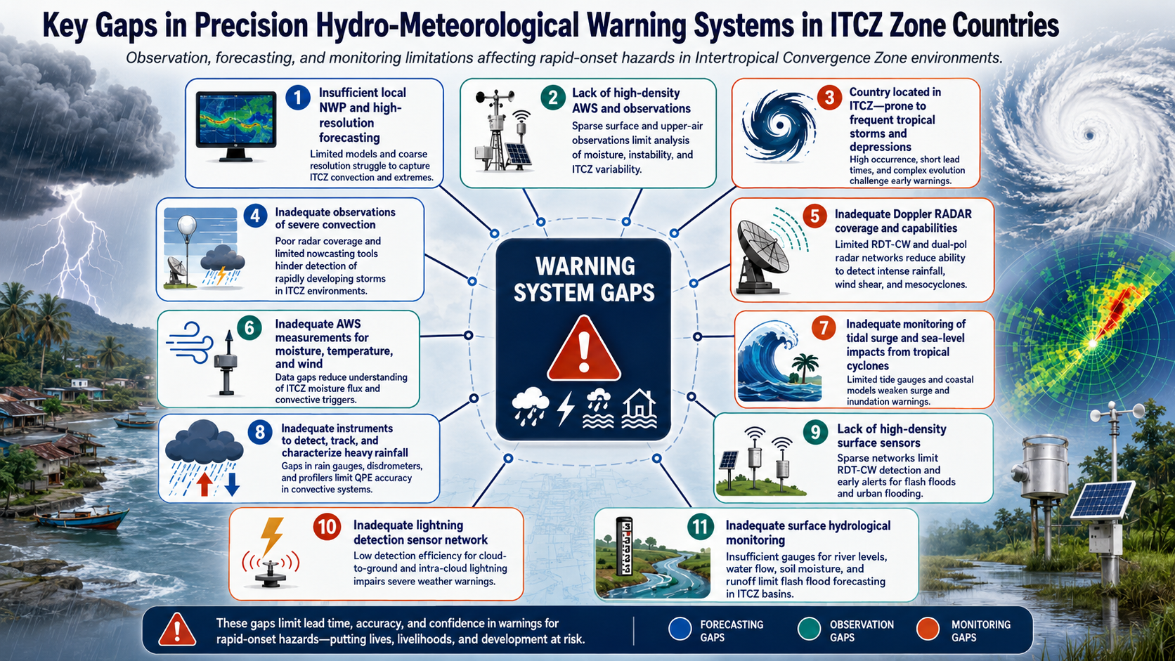
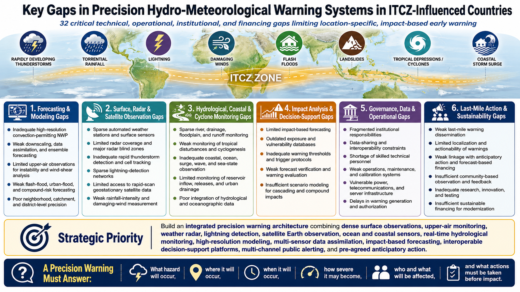
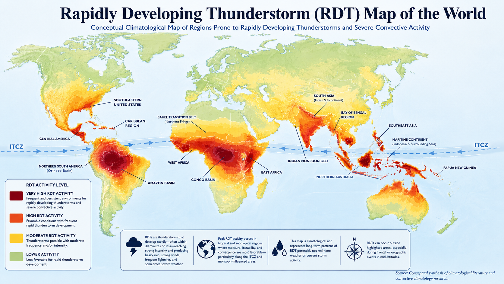
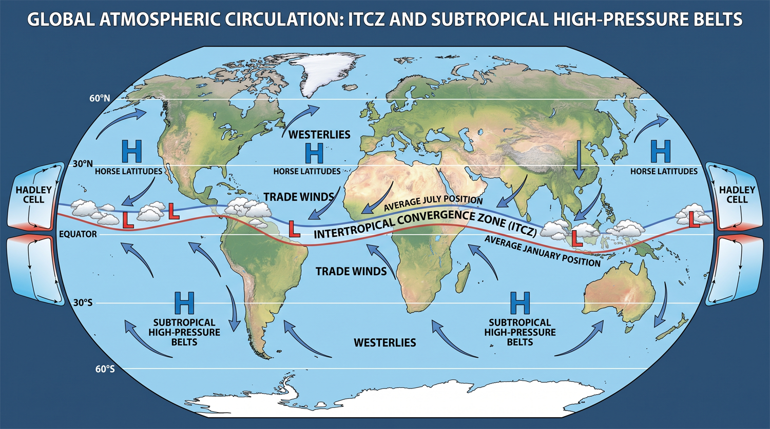
Countries located within or strongly influenced by the Intertropical Convergence Zone (ITCZ) over the sub-tropics are exposed to highly dynamic atmospheric and hydrological conditions, including rapidly developing thunderstorms, mesoscale convective systems, torrential rainfall, lightning, damaging wind gusts, flash floods, landslides, tropical depressions, cyclones, coastal storm surges, and prolonged wet and dry spells. The localized, rapidly evolving, and compound nature of these hazards requires high-resolution, observation-driven, impact-based, and continuously updated warning systems. However, major technical, institutional, operational, and financial gaps continue to limit warning precision.
- Inadequate High-Resolution Numerical Weather Prediction
Many ITCZ-influenced countries over the sub-tropics lack operational convection-permitting numerical weather prediction models capable of resolving localized thunderstorms, intense rainfall cells, squall lines, mesoscale convective systems, and rapidly developing tropical disturbances. Common limitations include dependence on low-resolution global forecasting products, Limited national capacity for model downscaling and data assimilation, Inadequate ensemble and probabilistic forecasting, Insufficient computing infrastructure, Weak model calibration using local observations, Limited integration of atmospheric, oceanographic, hydrological, and land-surface models, and inability to produce neighborhood, catchment, or district-level forecasts. As a result, forecasts may indicate a broad probability of rainfall while failing to identify its exact location, intensity, onset, duration, movement, and likely impacts.
- Sparse Automated Weather-Observation Networks
Many countries lack sufficiently dense networks of automated weather stations and surface meteorological sensors for monitoring essential climate and weather variables in near real time. Key deficiencies include insufficient measurements of Rainfall intensity, duration, and accumulation, surface temperature and humidity, atmospheric pressure, wind speed, direction, and damaging wind gusts, solar radiation and evapotranspiration, soil temperature and soil moisture, visibility, and cloud base height. Observation networks are often concentrated around airports, cities, or administrative centres, leaving rural settlements, coastal zones, mountain areas, river basins, agricultural regions, and climate-risk hotspots poorly monitored.
- Limited Weather-Radar Coverage
Weather-radar systems (Doppler Radar) are costly to procure, operate, calibrate, and maintain. In many least developed countries, existing radar networks are insufficient, outdated, poorly maintained, or unable to provide comprehensive national coverage. These limitations constrain the detection of rapidly developing thunderstorms; the monitoring of convective-cell formation, intensification, movement, and decay; the estimation of rainfall intensity and spatial distribution; and the identification of hail, strong downdrafts, microbursts, damaging wind gusts, squall lines, and mesoscale convective systems. They also weaken short-range rainfall forecasting, flash-flood nowcasting, and storm monitoring over densely populated settlements, critical infrastructure, and economically productive areas.
Across vast areas of the Global South, extensive radar-blind zones persist, leaving many high-risk and strategically important locations, including cities, towns, settlements, critical infrastructure, protected areas, and agricultural production zones, without adequate real-time weather surveillance.
- Inadequate Detection of Rapidly Developing Thunderstorms
Rapidly developing thunderstorms and convection-warning systems remain underdeveloped in many ITCZ countries. Existing systems may not adequately detect, track, characterize, and forecast individual convective cells. Important parameters are often insufficiently monitored or modeled, including Convective available potential energy, convective inhibition, updraft and downdraft strength, vertical wind shear, cloud-top cooling, storm-cell growth rate, echo-top height, precipitable water, lightning density, cell movement, and expected arrival time. This significantly constrains warning lead time for severe thunderstorms, torrential rainfall, flash floods, lightning, hail, and damaging wind gusts.
- Insufficient Lightning-Detection Networks
Surface-based lightning-detection networks are either absent or too sparse in many countries. Dependence on satellite-derived lightning information alone may not provide the spatial precision and latency required for localized warning services. Consequences include limited capacity to detect cloud-to-ground lightning, monitor lightning-jump signals associated with storm intensification, issue location-specific lightning warnings, protect schools, airports, farms, power systems, outdoor workers, and public gatherings, and integrate lightning information into severe-weather nowcasting.
- Limited Access to High-Frequency Satellite Data
Although satellite observations are essential across the ITCZ, many national services lack reliable access to, or operational capacity to process, high-frequency geostationary satellite products from systems such as EUMETCast, NOAA, Meteosat, FengYun, Himawari, GOES, and INSAT. Critical gaps include limited reception and processing facilities, inadequate access to rapid-scan imagery, weak cloud-top temperature and convective-growth analysis, limited satellite rainfall estimation, inadequate integration with radar and ground observations, shortages of trained satellite meteorologists, and dependence on externally prepared products with limited local customization.
- Weak Hybrid Observation and Data-Assimilation Systems
Precision warning requires integrating radar, satellite, automated weather stations, radiosondes, aircraft observations, lightning sensors, ocean buoys, hydrological stations, crowdsourced reports, and numerical models. In many countries, these systems operate separately. Major gaps include Incompatible data formats, lack of standardized application programming interfaces, weak quality-control procedures, limited real-time data exchange, absence of multi-sensor data-fusion platforms, insufficient three-dimensional atmospheric observations, and limited assimilation of local observations into forecast models. Without hybrid observations, forecasters cannot develop a complete atmospheric and hydrological picture.
- Inadequate Upper-Air Observation
Upper-air observation networks are sparse across many tropical regions. Radiosonde launches may be irregular, geographically limited, or dependent on external funding. This restricts monitoring of Atmospheric instability, Moisture profiles, wind shear, temperature inversions, freezing levels, jet streams, tropical-wave structures, conditions favorable for cyclone formation, and severe convection. Poor upper-air data also reduces numerical-model accuracy across data-sparse regions.
- Insufficient Monitoring of Tropical Disturbances and Cyclogenesis
Several ITCZ-influenced countries lie within or near breeding zones for tropical disturbances, depressions, cyclones, and monsoon low-pressure systems. However, oceanic and atmospheric monitoring systems are often inadequate. Key gaps include limited availability of ocean buoys, coastal automatic weather stations, wave and current sensors, sea-surface-temperature observations, ocean heat-content data, upper-ocean profiling, offshore radar and satellite-receiving capacity, Aircraft-based storm reconnaissance, and rapid-update coupled atmosphere-ocean models. These limitations reduce confidence in predicting cyclone formation, intensification, movement, rainfall, wind, waves, and coastal impacts.
- Inadequate Damaging-Wind Measurement
Standard automated weather stations may not be designed or positioned to capture extreme convective wind gusts, microbursts, downbursts, squalls, or cyclone-related surface winds. Gaps include Low temporal sampling frequency, inappropriate sensor exposure, poor station siting, limited wind-profiler coverage, Insufficient ruggedization for extreme conditions, loss of stations during severe storms, and weak integration of wind observations with radar-derived velocity products. Consequently, damaging wind warnings often remain generalized rather than location-specific.
- Weak Rainfall-Intensity Monitoring
Conventional daily rainfall gauges are inadequate for detecting rapid-onset hazards. Precision warning requires sub-hourly monitoring of rainfall intensity, accumulation, duration, spatial distribution, and storm movement. Many countries lack tipping-bucket rain gauges, disdrometers, dense urban rainfall networks, mountain and catchment rainfall sensors, radar-gauge rainfall calibration, near-real-time rainfall anomaly analysis, and automated threshold-based alerts. This limits the ability to predict flash floods, urban flooding, debris flows, landslides, and drainage system overflow.
- Sparse Hydrological Monitoring Networks
River basins, drainage systems, wetlands, reservoirs, canals, and floodplains are often insufficiently instrumented. Major monitoring gaps include river and stream water levels, discharge and flow velocity, floodplain inundation depth, drainage-channel water levels, urban drainage capacity, reservoir inflow and release, soil saturation, groundwater levels, runoff generation, sediment and debris movement. Hydrological stations are frequently manual, damaged, poorly maintained, or unable to transmit data in real time.
- Limited Flash-Flood and Urban-Flood Forecasting
Many warning systems focus primarily on major river flooding and provide insufficient coverage for localized flash floods, pluvial flooding, drainage congestion, and surface-water flooding. Key limitations include Lack of high-resolution digital elevation models, Incomplete drainage-network mapping, Limited catchment-scale hydrological models, Inadequate land-use and impervious-surface data, Weak rainfall-runoff threshold calibration, Limited monitoring of small and ungauged catchments, Lack of street-level and settlement-level flood modeling, Inadequate representation of blocked drains, waste accumulation, and informal settlements.
- Inadequate Coastal and Storm-Surge Monitoring
Coastal ITCZ countries frequently lack integrated systems for monitoring tropical cyclone winds, waves, tides, storm surge, coastal flooding, erosion, and saline intrusion.
Major deficiencies include insufficient Tide gauges, Wave buoys, Coastal radar, Coastal automatic weather stations, Bathymetric and topographic data, Real-time sea-level monitoring, coupled storm-surge and wave models, Coastal inundation maps, Community-level surge markers, and monitoring of compound river, rainfall, tide, and surge flooding.
These gaps may prevent accurate warnings for higher-category storms and rapidly escalating coastal inundation.
- Weak Landslide and Debris-Flow Monitoring
In mountainous and high-rainfall ITCZ regions, landslide warning systems remain poorly developed.
Common gaps include Sparse soil-moisture sensors, Limited ground-movement monitoring, Inadequate slope-stability instrumentation, Insufficient rainfall-threshold calibration, Lack of terrain-specific landslide models, Poor mapping of susceptible slopes, Limited integration of rainfall forecasts with geological conditions, and weak community reporting from remote mountain areas.
- Limited Multi-Hazard and Compound-Risk Forecasting
Warnings are often generated separately for rainfall, river flooding, wind, lightning, landslides, coastal flooding, and health risks. This fragmented approach does not adequately represent cascading and compound events.
Examples include cyclone wind, storm surge, rainfall, and river flooding occurring simultaneously; torrential rainfall triggering urban flooding, landslides, infrastructure failure, and disease outbreaks; drought followed by intense rainfall causing erosion and flash flooding; reservoir releases coinciding with heavy rainfall and high tides; and lightning and wind disrupting communication and power systems during emergencies.
Integrated multi-hazard forecasting and scenario modeling remain limited.
- Insufficient Impact-Based Forecasting
Many services continue to issue hazard-based forecasts describing expected rainfall, wind, or river levels without explaining the consequences for exposed populations, infrastructure, livelihoods, and services.
Precision warning systems require the integration of Hazard intensity, Exposure, Vulnerability, coping capacity, Critical-infrastructure location, Population mobility, Agricultural calendars, Health risks, Sector-specific thresholds, and historical damage and loss data.
Without this integration, decision-makers may receive technically accurate forecasts but insufficient information on what will happen, where, to whom, and what action is required.
- Outdated Exposure and Vulnerability Databases
Impact modeling is constrained by incomplete, outdated, or inaccessible information on Population distribution, informal settlements, Buildings and construction types, Roads, bridges, schools, hospitals, and power infrastructure, Crops, livestock, fisheries, and markets, Water and sanitation facilities, Vulnerable groups, Evacuation routes and shelters, Critical supply chains, and seasonal population movements. Data may also be aggregated at administrative levels too coarse for precision warning.
- Inadequate Warning Thresholds and Trigger Protocols
Hazard thresholds are often based on generalized national standards rather than locally calibrated relationships between meteorological conditions, hydrological responses, and observed impacts.
Typical gaps include limited historical event databases; insufficient return-period analysis; lack of catchment-specific rainfall thresholds; weak calibration of river-level danger points; inadequate lightning and wind-gust thresholds; unclear anticipatory-action triggers; and failure to update thresholds after land-use, climate, or infrastructure changes.
- Weak Forecast Verification and Warning Evaluation
Many systems do not systematically evaluate forecast accuracy, warning lead time, false alarms, missed events, spatial precision, public understanding, or protective action.
Without structured verification, agencies cannot determine which models perform best, whether warning thresholds are appropriate, where observation gaps are most critical, whether users received and understood the warning, whether the warning resulted in timely action, and whether forecasts are improving over time.
- Fragmented Institutional Responsibilities
Meteorological, hydrological, oceanographic, geological, disaster management, water, agriculture, transport, energy, health, and local government institutions often maintain separate mandates and data systems.
This may lead to Duplication of monitoring systems, Restricted data access, Delayed warning approval, Conflicting forecasts, Unclear operational authority, Limited joint situation analysis, Weak coordination between national and local levels, and inadequate accountability for missed warnings.
- Data-Sharing and Interoperability Constraints
Observation and forecast data may be treated as institutional assets rather than public-safety resources.
Common barriers include Restrictive data policies, High data-access costs, Limited transboundary exchange, Non-standardized databases, Lack of open geospatial services, Incompatible software, Delayed manual reporting, Weak cybersecurity and data-governance arrangements, and dependence on proprietary systems.
These constraints are particularly serious for transboundary river basins and storms moving across national borders.
- Shortage of Skilled Technical Personnel
Precision systems require meteorologists, hydrologists, oceanographers, radar specialists, satellite analysts, numerical modelers, data scientists, engineers, geospatial specialists, software developers, technicians, risk analysts, and warning communicators.
Many institutions face Insufficient staffing, Limited specialization, High staff turnover, Inadequate professional training, Weak university–operational-agency collaboration, Dependence on short-term consultants, and limited twenty-four-hour forecasting and maintenance capacity.
- Weak Operations, Maintenance, and Calibration
Observation instruments are often installed through externally financed projects without adequate long-term provisions for maintenance, spare parts, telecommunications, calibration, power supply, software licensing, and technical support.
This results in High rates of station failure, Missing or unreliable data, Long repair periods, Uncalibrated sensors, discontinued services after project closure, and inconsistent historical records.
- Vulnerable Power and Telecommunication Infrastructure
Precision warning systems depend on continuous electricity, telecommunications, internet connectivity, and cloud or server infrastructure. These systems may fail during the very events they are intended to monitor.
Key gaps include Lack of backup power, Poor mobile coverage, Single communication pathways, Inadequate satellite communication, Weak data redundancy, Limited offline functionality, Insufficient disaster-resistant equipment, Centralized systems with no failover capacity.
- Delays in Warning Generation and Authorization
Even where forecasts are available, warnings may be delayed by multi-layered approval procedures, bureaucratic controls, unclear mandates, or fear of false alarms.
This reduces effective lead time and can prevent rapid warning updates during fast-changing convective or hydrological events.
- Weak Last-Mile Warning Dissemination
Warnings often fail to reach people in remote, informal, coastal, mountainous, riverine, pastoral, forest, island, and conflict-affected areas.
Common dissemination gaps include Dependence on a single communication channel, Limited cell-broadcast or location-based alerting, Inadequate siren networks, Weak community radio coverage, Lack of multilingual and accessible messaging, Limited arrangements for people with disabilities, Insufficient redundancy during network failure, and failure to confirm whether warnings were received.
- Limited Warning Localization and Actionability
Warnings may cover large administrative areas, even when only a small locality is at risk. Messages may also use technical terminology without specifying expected impacts or required actions.
Precision warnings should specify Exact affected locations, expected timing, Hazard intensity, Confidence and uncertainty, anticipated impacts, Groups and assets at risk, Protective actions, Evacuation routes and safe locations, Update time, and expiry period.
- Weak Linkage with Anticipatory Action
Forecasts and warnings are not always linked to pre-agreed action plans, financing, logistics, social protection, evacuation, reservoir management, health preparedness, agricultural protection, or emergency-service deployment.
Major gaps include Undefined action thresholds, Lack of forecast-based financing, Delayed release of emergency funds, Unclear agency responsibilities, Limited pre-positioning of supplies, Absence of sector-specific early action protocols, and weak integration with local contingency plans.
- Insufficient Community-Based Observation and Feedback
National observation systems often underuse community reports, local knowledge, crowdsourced data, social-media intelligence, and local sensor networks.
This reduces the ability to validate Local rainfall, Drainage overflow, River and stream conditions, Flood depth, Landslide occurrence, Storm damage, warning receipt, and community response.
Community observations should complement, not replace, scientifically maintained national monitoring systems.
- Inadequate Research and Development
Operational agencies often have limited capacity to test emerging technologies such as artificial intelligence, machine learning, Internet of Things sensors, unmanned aerial vehicles, crowdsourced observations, digital twins, object-based storm tracking, and automated impact forecasting.
Research outputs may remain disconnected from operational warning services because of weak institutional partnerships, limited funding, unavailable datasets, or lack of validation.
- Insufficient Sustainable Financing
Many warning systems remain dependent on project-based donor financing rather than predictable national budgets. Funding gaps affect Equipment procurement, Network expansion, Station maintenance, Telecommunications, Software licensing, Skilled staffing, Research and development, Community preparedness, System verification, and continuous modernization.
Capital investment without recurrent financing frequently produces incomplete or unsustainable systems.
Strategic Priority
ITCZ-influenced countries require an integrated precision hydro-meteorological warning architecture combining dense surface observations, upper-air monitoring, weather radar, lightning detection, satellite Earth observation, ocean and coastal sensors, real-time hydrological monitoring, high-resolution modeling, multi-sensor data assimilation, impact-based forecasting, interoperable decision-support platforms, multi-channel public alerting, and pre-agreed anticipatory-action mechanisms.
The central objective should be to move from generalized national forecasts toward location-specific, time-specific, impact-specific, and action-oriented warnings that clearly communicate
A precision warning must clearly specify the anticipated hazard, its expected location and timing, its potential severity, the people, assets, infrastructure, livelihoods, and services likely to be affected, and the protective or anticipatory actions required before impact.
[Note: The Multi-Hazard Early Warning Consortium (MHEWC) would welcome the opportunity to meet with WMO and other relevant international organizations to discuss this issue in greater depth and explore how early warning systems and impact-based meteorological forecasting services can be strengthened to better protect and serve frontline communities. To arrange a meeting, please call +880 1711 979179 or email zmsajjad@gmail.com. ]