Design & Implementation of Multi-Hazard Early Warning System(MHEWS) – New Concept
Developed by Z M Sajjadul Islam, Coordinator Early Warning for All (EW4ALL) – UNDRR, ROAS
Executive Summary
The proposed Early Warning for All(EW4ALL) implementation strategy considers Somalia’s existing disaster/climate risk, fragility, conflict, and vulnerability (FCV) context. A robust implementation of Information and Communication Technology (ICT) for multi-hazard/disaster risk management governance systems is considered the most appropriate solution to the governance paradox. It concurrently leverages how to overcome governance fragility challenges and bridge the gaps among last-mile non-state development actors, the private sector, and central-level federal and state actors (government) in the disaster risk management governance system. The most considerable imperative is that the Somali mobile penetration reaches 80% of the country’s population, laying the groundwork for an ICT-driven, agile online system structured as an open-ended system to facilitate the implementation of the EW4ALL pillar actions for Somalia.
The proposed ICT tools-driven online system of the national multi-hazard early warning system (NMHEWS) underscores the technical nexus of fostering potential digital partnerships among all actors through the implementation of ICT tools-based informed multi-hazard risk governance management and the overall improvement of hydrometeorological services and Early Warning Systems. More specifically, the purpose of this report is to provide valuable insights into the nuances of ICT-driven early warning systems (EWS) implementation within affected contexts against growing natural hazards, offering technical risk-governance and identifying entry points where an ICT tools supported mechanism to link climate frontline stakeholders, community and smallholder entrepreneurs as last-mile key informant and to be interacting them with the EW4ALL system, enhancing last-mile stakeholder digital coordination, optimizing multi-hazard risk-informed and climate proof local development planning, resource allocation, and fostering community readiness to better preparedness for, respond to and resilience-building to any impending hazardous multi-hazards.
Contents
1.1 Objective of the Assessment and Full-scale EW4ALL Implementation Strategy Development: 9
2.0 Challenges of Multi-hazard Risk Management Governance in the Somalin FCV context 13
2.2 Objective of the Interoperable NMHEWS for Somalia: 20
2.3 Urgency of Implementation of ICT-based Multi-Hazard Risk Management Governance: 21
2.4 Key indicators of ICT-driven EW4ALL action priorities for Somalia in FCV context. 22
3.0 Pillar 1 Implementation Strategy (Improving Disaster Risk Knowledge): 24
3.1 The ongoing SoDMA Structure : 24
3.2 The NMHEWC ongoing operational structure : 25
3.3 Proposed Interoperable NMHEWS : 27
3.3.1 Establish a digital partnership among the stakeholders and prime actors: 27
3.3.2 Design and implementation of an Interoperability Online geospatial system: 30
3.6 Implementation of Geospatial Platform ( Open-Source/ ESRI Licensed ) : 33
3.6.1 Component of Open-Source Geospatial Platform: 34
3.6.2 Installation of Geoserver : 35
3.6.5 Deploying Web based data sharing platform with apps : 38
3.6.6 Implementing Web converting common alerting protocol (CAP )apps : 38
3.8 Improving Risk Knowledge of stakeholders. 42
Options to bridge last-mile multi-hazard risk knowledge gaps. 42
3.9 Improving Risk Knowledge of Sector Value Chain Operators: 42
3.10 The following are the recommendations for Disaster Risk Knowledge Management Governance. 43
3.11 Review Stakeholder Partnership & Coordination Mechanism.. 47
3.12 Partnership for Data Coordination and Exchange Mechanism.. 48
3.13 Upgrade and Activation of an Interoperable Situation Room and NMHEWS at SoDMA–NMHEWC (): 50
3.14 NMHEWS service deliverability for improving risk knowledge: 53
3.14.1 Understanding Disaster Risk of the Locality. 53
3.14.2 Frontline community needs to understand Disaster Risk in their Locality : 54
3.14.3 Enhancing the risk knowledge of Smallholder crop farmers: 54
3.14.4 Climate Vulnerable Productive Sector Departments: 61
3.14.6 Improving risk knowledge of Humanitarian actors: 70
3.14.7 Improving risk knowledge of entrepreneurs & Value Chain Operators. 72
4.0 Pillar 2 : Improving surface observation, Monitoring, and Forecasting. 74
4.1 Current forecasting mechanism of Somalia : 75
4.2 Indicative challenges in national forecasting service delivery : 75
4.3 Recommendations on improving the national forecasting service delivery: 76
4.4 Recommendations on improving the sector-specific national forecasting service delivery : 77
4.5 Recommendations on improving hydrometeorological services: 79
5.0 Pillar 3 Implementation Strategy ( Warning dissemination and communication) 101
5.1 Indicative Challenges of Warning Dissemination and Communication. 102
5.2 Developing a Common Alerting Protocol(CAP) : 106
5.4 Develop and disseminate a common alerting protocol (CAP) on imminent hazards, weather : 110
5.5 Improving terrestrial Broadcasting. 112
5.7 NCA Mandates National Broadcasters, News Outlets for dissemination. 116
5.8 UN Clusters data contribution for impact forecasting. 117
6.0 Pillar 4 : Improving Preparedness and Response Capabilities. 121
6.1 Central Objectives for Improving Preparedness and Response Capabilities. 121
6.2 Recommendations on a Coherent Sector-Level Actionable Policy Framework. 121
6.3 Improving Forecast-based Anticipatory Action Planning Capacity: 121
6.5 Hazard risk-informed Humanitarian actions. 123
6.7 Improving Last-Mile Disaster Preparedness Capacity. 125
6.8 Improving Community-based Early Warning Capacity. 127
6.9 How to develop the Anticipatory Action (AA) Framework. 128
6.10 Improve the disaster risk financing system: 135
6.11 Supporting the implementation of risk-informed DRM and DRR. 136
6.12 Improve DRM Planning at the local level : 136
6.13 Gender responsive DRR framework : 137
Acronym
AA | Anticipatory Action |
AM | Amplitude Modulation |
AMM | Africa Media Monitor |
APIs | Application programming interfaces |
ARC | African Risk Capacity |
AWD | Acute Watery Diarrhea |
AWS | automated weather station |
BCPs | Business Continuity Plans |
CAP | Common Alerting Protocol |
CB | Cell-Broadcast |
CBDRM | Community Based Disaster Risk Management |
CBO | Community-based organization |
CBS | Central Bank of Somalia |
CCA | Climate Change Adaptation |
CCM | Convention on Cluster Munitions |
CIMA | International Centre for Environmental Monitoring |
CPC | Civil protection committee |
CREWS | Climate Risk and Early Warning Systems |
CRVA | Climate risk and vulnerability assessments |
CSO | Civil Services Organization |
DDMT | Disaster Management Team |
DFID | Department for International Development Government of the United Kingdom |
DINA | Drought Impact and Needs Assessment |
DM | Disaster Management |
DMA | Disaster Management Agency |
DMC | Disaster Management Committee |
DRM | Disaster Risk Management |
DRMCG | Disaster Risk Management Coordination Group |
DRR | Disaster Risk Reduction |
DTM | Displacement Tracking Matrix |
DTS | Disaster Tracking System |
EOC | Emergency Operation Centre |
ETT | Emergency Tracking Tools |
EW | Early Warning |
EW4ALL | Early warning for all |
FAO | Food and Agriculture Organization |
FEWSNET | Famine Early Warning Systems Network |
FGS | Federal Government of Somalia |
FM | Frequency Modulation |
FSNAU | Food Security and Nutrition Analysis Unit |
GDP | Gross domestic product |
GIS | geographic information system |
GMAS | Global Multi-hazard Alert System |
GPS | The Global Positioning System |
GSM | Global System Mobile |
GTOS | Global Terrestrial Observing System |
HC | Humanitarian Coordinator |
HCT | Humanitarian Country Team |
HPC | High-performance Computer |
IBF | Impact-based Forecast |
ICPAC | IGAD Climate Prediction and Applications Centre |
ICS | Incident Command System |
ICT | Information and Communications Technology |
IDP | Internally Displaced Person |
IDRR | International Day for Disaster Reduction |
IFAD | International Fund for Agricultural Development |
IFRC | International Federation of Red Cross and Red Crescent Societies |
IGAD | Intergovernmental Authority on Development |
IGADD | Intergovernmental Authority on Drought and Development |
LITK | local, indigenous and traditional knowledge |
ILK | Indigenous and local knowledge |
INGO | International Non Government Organization |
IOM | International Organization for Migration |
IPCC | Intergovernmental Panel on Climate Change |
ITCZ | Inter-Tropical Convergence Zone |
ITU | International Telecommunication Union |
IRV | Interactive Voice Response |
L & D | Loss and Damage |
LB-SMS | Location-based SMS |
LCG-DER | local coordination group on disaster emergency response |
LNHAs | Local National Humanitarian Actors |
LNNGOs | Local and National NGOs |
MoAI | Ministry for Agriculture and Irrigation |
MoFBE | Ministry of Fisheries and Blue Economy |
MOLFR | Ministry of Livestock, Forestry And Range |
MoPIED | Ministry of Planning, Investment and Economic Development |
MoEWR | Ministry of Energy & Water Resources |
MoHADM | Ministry of Humanitarian Affairs and Disaster Management |
MTR | Mid Term Review |
NAPA | National Adaptation Plan of Action |
NCA | National Community Authority |
NDMF | National Disaster Management Fund |
NDRMC | National Disaster Risk Management Council |
NDVI | Normalized Difference Vegetation Index |
NMHEWC | National Multi-hazard Early Warning Center |
NMHEWS | National Multi-hazard Early Warning System(Online) |
MHEWS | Multi-hazard Early Warning System(Online) |
NGO | Non-Government Organization |
NMHSs | National Meteorological and Hydrological Services |
NSO | National Statistical Office |
OCHA | Office for the Coordination of Humanitarian Affairs |
OI | Officer In-charge |
OPM | Office of the Prime Minister |
PDNA | Post-disaster loss, damage, and needs assessment |
Q&A | Questions and answers |
RPDNA | Rapid Post-Disaster Needs Assessment |
RVAC | Risk and Vulnerability Assessment Committee |
RS | Remote Sensing |
RMC | Regional Meteorological Center |
RSMCs | Regional Specialist Meteorological Center |
SADD | sex, age, disability disaggregated data |
SDG | Sustainable Development Goals |
SDRMCG | Somalia Disaster Risk Management Coordination Group |
SFDRR | Sendai Framework on Disaster Risk Reduction |
SMS | Short Message Service |
SNDMP | Somalia National Disaster Management Policy |
SNDP | Somalia National Development Plan |
SoDMA | Somalia Disaster Management Agency |
SoD | Standing orders in Disaster |
SoP | Standard Operating Procedure |
SRCS | Somalia Red Crescent Society |
SWALIM | Somalia Water and Land Information Management |
SWALIM | Somalia Water and Land Information Management |
TWG | Technical Working Group |
UAV | Unmanned aerial vehicle |
UHF | Ultra-high frequency |
UN | United Nations |
UNCCA | United Nations Convention against Corruption |
UNCDF | UN Capital Development Fund |
UNDP | United Nations Development Programme |
UNDRR | United Nations Office for Disaster Risk Reduction |
UNFPA | United Nations Population Fund |
UNHCR | United Nations High Commissioner for Refugees |
UNICEF | United nations international children’s emergency fund |
UNRCO | United Nations Resident Coordinator Office |
UNV | UN Volunteers |
VAC | Vulnerability Assessment Committee |
WASH | Water, sanitation, and hygiene |
WFP | UN World Food Programme |
WHO | World Health Organization |
WMO | World Meteorological Organization |
1.0 Introduction
Considering Somalia’s disaster and climate risk profile and its fragility, conflict, and vulnerability (FCV) context, Somalia would benefit from implementing an ICT-enabled online platform for a National Multi-Hazard Early Warning System (NMHEWS). Such a system is critical to deliver timely and accurate hazard warnings, impact-based forecasting, weather alerts, and sector-specific advisories, while also enabling risk-informed and climate-resilient planning and strengthening disaster risk management (DRM) governance. The system is intended to improve preparedness, response, and recovery capacities for climate frontline (last mile) stakeholders affected by extreme weather events and other hazards.
This implementation strategy is informed by a field mission conducted to support the institutional assessment and stakeholder consultations for Early Warnings for All (EW4ALL) implementation in Somalia. The mission assessed existing institutional capacity for hydrometeorological service delivery, including its operational modalities and multi-dimensional requirements across key national and subnational stakeholders.
The assessment’s primary objective was to evaluate the institutional capacity required to fully implement EW4ALL, including structures, methodologies, tools, and processes. It also examined the capacity of core stakeholders to implement EW4ALL pillar actions and to identify practical implementation strategies that reflect Somalia’s FCV realities.
A key component of the assessment included technical review missions to the Somalia Disaster Management Agency (SoDMA) National Multi-Hazard Early Warning Centre (NMHEWC) to examine operational readiness and service delivery capacity. The review covered ICT infrastructure and systems, including databases, hardware, and software environments, system architecture, network topology, internet backbone, data connectivity, and human resource capacity for disaster risk information management.
In addition, the assessment examined the system-level interoperability requirements for operationalizing EW4ALL pillar actions, which depend on effective coordination and partnership mechanisms. This included reviewing capabilities related to hazard detection, forecasting, impact analysis, risk communication, and preparedness and response functions.
UNDRR has supported Somalia to strengthen national capacity for EW4ALL implementation through a roadmap and associated action plans. Accordingly, the assessment also reviewed broader DRM governance capacity, including the presence and functionality of local government DRM systems, with reference to typical multi-hazard early warning system structures applied in African country contexts.
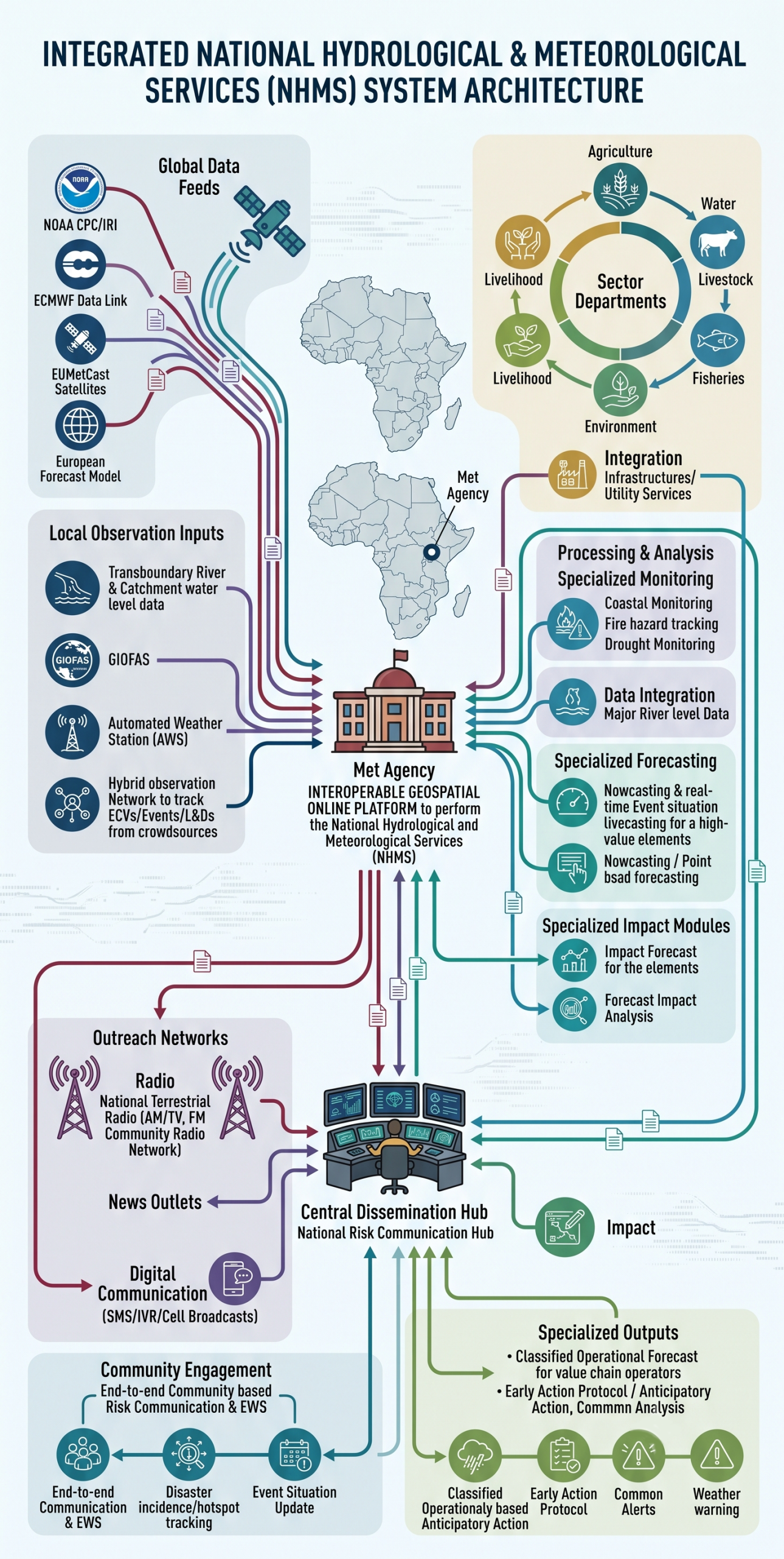
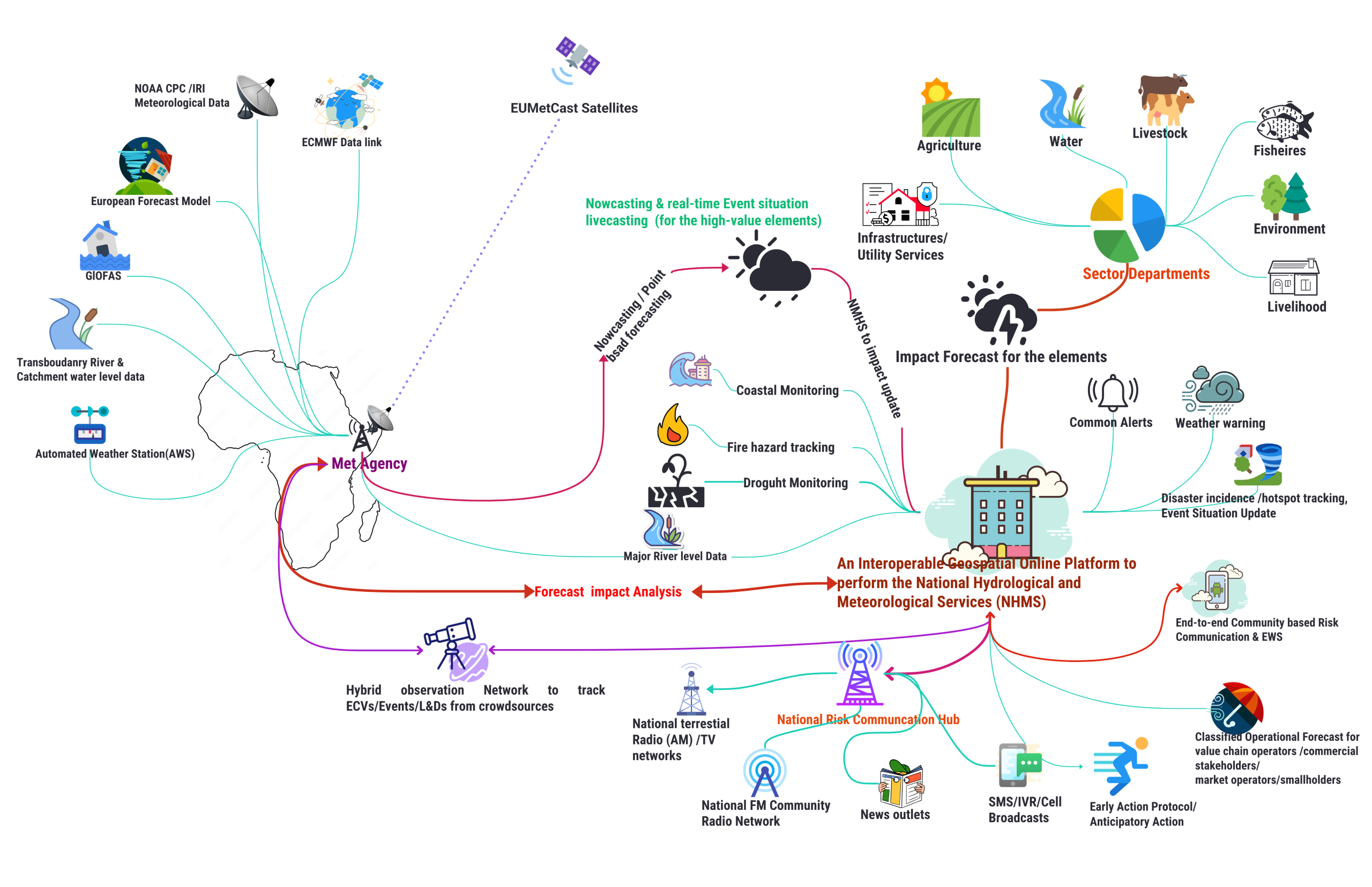
1.1 Objective of the Assessment and Full-scale EW4ALL Implementation Strategy Development:
- Assess institutional capacity: Evaluate Somalia’s institutional capacity to strengthen multi-hazard risk knowledge, enhance preparedness for multi-hazard early warnings, and improve warning dissemination to last-mile stakeholders.
- Diagnose NMHEWS performance and governance gaps: Review the current multi-hazard early warning system, identify operational bottlenecks and gaps in inclusive risk governance, and propose recommendations and a prioritized way forward.
- Consult stakeholders and define implementation entry points: Through stakeholder consultations, assess and diagnose:
- risk knowledge management and data flows;
- hazard detection, forecasting, and delivery of precision/impact-based warnings;
- multi-hazard risk communication gaps and requirements for systemic improvement;
- institutional mandates, operating procedures, and interoperability mechanisms;
- partnership, coordination, and preparedness/response management capacity.
- Based on these findings, identify underlying constraints, recommend corrective actions, and develop an EW4ALL implementation strategy tailored to Somalia’s FCV context.
1.2 Assessment Methodology
The assessment applied a mixed-methods approach combining stakeholder consultations, technical site inspections, and desk-based reviews. The mission was conducted in March 2025 with Key Informant Interviews (KIIs) with priority stakeholders, including relevant sector ministries/departments and UN agencies, to examine institutional capacity and readiness to implement EW4ALL pillar actions.
In parallel, the team conducted physical visits to the National Multi-Hazard Early Warning Centre (NMHEWC) to review operational and ICT readiness, including infrastructure, hardware, and software environments, communication tools, databases, servers, storage systems, internet connectivity, and the status of digital partnerships and data exchange arrangements with other key actors.
A complementary desk review assessed publicly available information and service delivery practices, including institutional websites, information disclosure policies, relevant strategies, and NMHEWC products and services intended for end users. The assessment further reviewed the current stakeholder coordination and partnership arrangements supporting multi-hazard early warning service delivery, including the extent and quality of last-mile stakeholder engagement across Disaster Risk Management (DRM) functions and EW4ALL pillar activities.
Stakeholder interactions were guided by structured questionnaires and interview guides to identify indicative gaps, constraints, and priority actions to strengthen the system.
Data collection instruments and methods
- Key Informant Interviews (KIIs) with government, sector actors, and UN agencies
- Technical site inspection of NMHEWC ICT and operational systems
- Review of EWS products/services and dissemination mechanisms
- Mapping/review of coordination and partnership mechanisms
- Structured questionnaires/interview guides to capture gaps and recommendations

Figure 1: Institutional Assessment Methodology
- NMHEWC operations and EW4ALL alignment
- What operational structure and service delivery capacity gaps exist at the NMHEWC in relation to the EW4ALL Roadmap, and what are the indicative challenges/barriers?
- To what extent do NMHEWC mandates, SOPs, workflows, and products support end-to-end delivery (detection > forecasting > communication > response)?
- ICT systems infrastructure, IT Applications & ICT Governance, and human resources ( MoEWR , SoDMA, NCA, and sector institutions)
- What is the current status of ICT systems across MoEWR-hydrmet services, SoDMA, NCA, and key sector departments, challenges, barriers (Hardware, High Computing System, software, Optical Fiber connectivity, cybersecurity, interoperability, and IT-capable human resources)?
- What are the principal constraints affecting service delivery (systems reliability, hosting, data management, maintenance, staffing, and sustainability)?
- Level of Geospatial Services, GIS-based mapping, remote sensing analytics, and geospatial field data acquisition and processing systems
- What is the current functional capacity of the GIS & Remote Sensing unit (hardware/software, staffing, workflows, field-level GIS data collection, sectoral elements level data collation, and sector level GIS map production)?
- What tools and processes exist to support geospatial data-driven decision-making (e.g., hazard/risk maps, atlases, dashboards, reporting products), and what are the gaps?
- Risk Knowledge, Data Systems, and Assessment Capacity – Key Questions
- NHMS/EWS minimum capabilities: What is the current status of minimum NHMS/EWS capacity for hazard and risk data collection, risk data management, and development/maintenance of national and sectoral risk data repositories?
- Loss and Damage and post-disaster assessments: What mechanisms exist for Loss and Damage (L&D) data collection and reporting, and what is the institutional capacity to conduct PDNA/RPDNA (including coordination arrangements, methodologies, tools, staffing, and data availability)?
- Sector capacity for climate and multi-hazard risk assessments: What is the existing capacity of climate-vulnerable sector ministries/departments to undertake climate and multi-hazard risk assessments (methodologies, guidelines, tools, data inputs, workflows, and quality assurance), and what are the priority gaps and recommendations?
- CRVA and sectoral risk datasets: What is the capacity for sector-level Climate and Risk/Vulnerability Assessment (CRVA), including:
- collection and management of hazard, exposure, and vulnerability data;
- availability and quality of statistical datasets on built infrastructure and basic services (asset registries and service-attribute databases);
- systems for collecting, storing, and using socio-economic and demographic datasets, including age-, sex-, and disability-disaggregated data (SADD);
- existence and functionality of databases/archives and repositories; and
- capability to produce decision-support products (e.g., maps, atlases, profiles, dashboards, and analytical reports).
- District/field-level risk knowledge management: What is the status and effectiveness of risk knowledge management systems operated by sector extension departments at district and field levels, including community-level understanding of multi-hazard and climate risks affecting livelihoods and livelihood assets?
- Indigenous knowledge and local coping mechanisms: To what extent are local and indigenous coping knowledge systems documented and mainstreamed into risk-informed community-level DRM/DRR/CCA planning and implementation (including participatory processes, inclusion and safeguarding measures, and feedback loops)?
- Hydrometeorological services and observation networks
- What is the current level of national hydrometeorological service capacity, including the status of observation stations(Automated weather station, Manual station, weather observer level data collection, crowdsourced data collection, overall data transmission, collation, quality control, and processing mechanisms?
- What is the functional capacity for forecasting (deterministic/probabilistic), impact-based forecasting, bulletin preparation, and forecast verification?
- Weather and multi-hazard impact Forecasting systems, transboundary information/data exchange, and operational protocols
- What data-sharing and information exchange mechanisms exist with upper-riparian/transboundary countries (e.g., Ethiopia, Kenya) for flood, flash flooding, and heavy rainfall forecasting?
- What is the level of hydromet data sharing protocol from the hydromet stations of transboundary countries
- What is the current status of inland flood forecasting, heavy rainfall outlook systems, operational forecasting systems, impact forecasting systems, and overall forecasting capability?
- What is the status of Forecast-based Early Action protocols, triggers, and SOPs (including roles, thresholds, and decision-making processes)?
- Risk communication and dissemination systems (national to last-mile)
- What is the current national risk communication framework (roadmap, structures, processes, and responsibilities), and what gaps constrain performance?
- What is the current risk dissemination framework channels, workflows, and governance and how effective is it in reaching last-mile stakeholders?
- What is the status of collaboration with national media outlets (radio/TV), including mandates, MoUs, airtime arrangements, and accountability mechanisms for broadcasting routine forecasts and emergency bulletins?
- How do last-mile communities in off-grid, remote, or hard-to-reach areas receive warnings, and what barriers affect accessibility and timeliness?
- What are the key dissemination bottlenecks (technical, institutional, linguistic, trust-related, security/access constraints), and what measures could address them?
- To what extent are warnings understandable and actionable for frontline communities (language, format, lead time, relevance, and feedback loops)?
- Partnerships, coordination, and governance (national to local)
- What stakeholder partnership and coordination framework currently exists, challenges/barriers for DRM governance, risk/vulnerability assessment, and risk-informed sector planning?
- How can national structures be effectively partnered with CERWS GHA and EW4ALL for full-scale implementation (roles, data exchange, coordination protocols, and governance arrangements)?
- What is the level of ICT/GIS and remote sensing capacity within FAO-SWALIM / MoEWR, including map production systems and data services, and how can it integrate with NMHEWS?
- Local governance, DRM structures, and community-based mechanisms
- What is the current DRM structure and risk governance mechanism at national and local levels, including the functional status, challenges of Civil Protection Committees (CPC) / Disaster Management Committees (DMC)?
- What is the status and quality of disaster preparedness, response, and recovery planning processes, including local-level DRM plans (district/village)?
- How effective is the Disaster Emergency Declaration process, including UN/INGO-led cluster coordination, response mobilization, and humanitarian action linkages?
- How are sector-level DRR actions coordinated at local level, and how do state and non-state actors engage in gender-inclusive, participatory local/clan-level development planning and gender-inclusive DRR planning?
1.3 Consultation Process:
The consultation process comprised structured meetings and technical discussions with key national institutions, sector ministries, UN agencies, and service delivery partners to validate the assessment scope, gather operational insights, and identify gaps and priorities for EW4ALL implementation.
- SoDMA / NMHEWC consultations: Meetings were held with the SoDMA NMHEWC team and relevant departments, including the ICT Department, Hazard/Risk Analysis Team, DRR Department, Humanitarian Affairs Department, Planning Unit, and Monitoring & Evaluation (M&E), as well as other relevant officials and stakeholders.
- Sector ministry consultations: Consultations were undertaken with sector ministries and departments responsible for climate-sensitive livelihoods and essential services, including Livestock, Agriculture, and Water Resources.
- UN agency consultations: Technical consultations were conducted with UN agencies supporting early warning, anticipatory action, and resilience programming, including UNDP, FAO, and WFP.
- Hydromet technical working group consultations: Engagements were conducted with the national hydrometeorological services technical working group under the Ministry of Energy and Water Resources (MoEWR), including discussions related to the Somalia Water Sources Information Management System (SWIMS/SWALIM, as applicable) and associated data and service delivery arrangements.
- Media and communications consultations: Meetings were held with the National Communications Authority (NCA) and national broadcasters to discuss constraints affecting weather forecasting dissemination, bulletin preparation, and public alerting arrangements.
2.0 Challenges of Multi-hazard Risk Management Governance in the Somalin FCV context
- Political fragility and a centralized governance system for risk-informed development:
Climate/multi-hazard risk management governance processes encompass a concerted approach among sectors and stakeholders that need to address all cross-cutting issues. Systematic and cohesive policy alignments, as well as inclusive & concerted programmatic interventions, are undertaken by the sectors. Inter- and intra-institutional partnership and coordination mechanisms are also in place. However, it also requires a holistic sectoral agreed consensus on risk assessment & information sharing, coordination, collaboration, an inclusive level of participatory last-mile local climate governance system is in place, local resource mobilization for the climate resilient local development actions, service delivery capacity stakeholders, and inclusive and finally the participatory engagement of last-mile stakeholders and frontline community with the localized risk-informed development initiatives.
In Somalia, federal and state actors-led service deliveries to the last mile are hindered by fragmented and self-proclaimed governance, clan-based fragility, a territorially fragmented governance system, conflicts, and a largely siloed approach to CSO-led local development service deliveries. The diagram below illustrates that Somalia has a limited extent of nexus between the centralized nature of federal, member state governance systems, poorly functioning district local governments, and sector departments, hindering the expansion of risk-informed service delivery at the last mile. On the other hand, the most prominent last-mile development actors are INGO-led CSOs and UN Agencies, which mostly adopt a siloed approach and are less partnered with government actors to bring up an inclusive climate risk governance management system for Somalia.
Figure 2: Political fragility and a centralized governance system
In this paradoxical context, binding all relevant stakeholders digitally /remotely, mandating them with ICT-driven strategic partnership and coordination, avoiding the looming governance fragility, and transforming them into ICT-enabled stakeholder-partnered, inclusive multi-hazard early warning systems and risk-informed local development will be leveraged to distantly nexus the platform to the virtually centralized and decentralized functioned digital multi-hazard risk governance system.
Unlocking all fragmented governance paradoxes to create a digitally functioning and level playing field with nexus functional partnerships that hold all stakeholders, sectoral actors, local government entities, CSOs, and frontline communities accountable to the affected population(digitally) out of the box, and eliminating the already suffering from FCV paradigms of governance.
- Current practices of the Silo-approach implementation modality:
Most federal and member-state actors (sector ministries, sector departments, and district administrations), as well as non-state actors (INGOs and CSOs), engaged in risk-informed development in Somalia, often operating through siloed modalities with limited coordination, partnerships, and systematic information disclosure. This fragmentation constrains the interactive, multi-stakeholder processes required to operationalize EW4ALL pillar actions, particularly those that depend on participatory planning, shared risk information, and coordinated last-mile implementation.
In principle, effective multi-hazard and climate risk management governance depends on an agreed framework for coordination and partnership, functional local governance arrangements, local resource mobilization for climate-resilient development actions, adequate service delivery capacity across stakeholders, and inclusive, participatory engagement of frontline communities and last-mile actors in localized risk-informed initiatives. However, as illustrated in Figure 2, Somalia’s sector ministries and departments have a limited partnership nexus across the centralized federal and member-state governance structures, weak district-level administrations, and sector delivery units. This weak institutional linkage constrains consistent risk-informed service delivery at the last mile. In parallel, UN agencies and INGOs often deliver regional and local development assistance through largely parallel systems, frequently relying on CSOs and maintaining limited structured integration with government-led governance and coordination mechanisms.
- Sector-level minimal level of data coordination, exchange, and disclosure:
Despite Somalia’s high mobile-phone penetration (estimated at approximately 80% of the population), many climate-vulnerable government sector departments at federal, member-state, and district levels continue to demonstrate limited adoption and effective use of ICT systems (hardware, software, and communications tools). In most cases, Management Information Systems (MIS) are either absent or underutilized for the systematic collection, inventorying, and management of multi-hazard and climate risk information. In parallel, tailored risk information products are seldom published through institutional websites or other routine public-facing channels, constraining transparency and limiting the usability of risk information for planning and decision-making.
These limitations are compounded by weak or non-existent data-sharing protocols and Memoranda of Understanding (MoUs), and by insufficient mandates and standard operating procedures to institutionalize multi-hazard risk assessment, repository development, and web-based data disclosure. Strengthening governance arrangements for data coordination, including agreed data standards, interoperability requirements, access and disclosure protocols, and formalized roles and responsibilities across central and subnational institutions, is essential to enable impact-based forecasting and to support risk-informed DRM and climate-resilient local development planning.
- Inadequate sector-level risk assessment, systematic risk repository development:
Effective disaster risk management (DRM) planning depends on timely, tailored, and localized risk information to inform preparedness, response, and recovery planning at district and community levels. Sector departments require consistent access to hazard, exposure, vulnerability, and impact data, supported by standardized methodologies and routinely updated repositories, to translate risk knowledge into actionable plans, budget allocations, and early-action triggers.
In Somalia, sector-level risk assessment capacity and systematic risk repository development remain limited. Risk information is often fragmented, project-based, and not institutionalized within government systems, which constrains access by sector departments for routine planning and decision-making. As a result, last-mile development and service delivery are frequently led by non-state actors, particularly local NGOs and other civil society organizations, who may generate useful localized datasets but often do so through parallel systems with limited integration into government-led repositories and planning processes. This undermines consistency, continuity, and the ability to scale risk-informed DRM actions across districts and sectors.
- Inadequate surface weather observation:
Somalia’s surface observation network remains largely manual, and time-series data are not acquired, quality-controlled, and transmitted in a systematic and regular manner. This undermines the ability to deliver point-based nowcasting, constrains the production of timely operational products, and limits forecast verification and continuous service improvement. As a result, national capacity for hydrometeorological monitoring, real-time tracking, and forecasting remains limited.
Key constraints include an insufficient number of automatic hydrometeorological stations, persistent challenges in data transmission, and limited provision for routine operation and maintenance (O&M). These gaps reduce the availability of reliable, timely observations required for improved forecasting, impact-based warning services, and downstream risk-informed DRM planning.
Closing Somalia’s observation gap is therefore a priority under EW4ALL Pillar 2 (detection, observation, monitoring, analysis, and forecasting). In coordination with national counterparts, WMO, UNDP, and UNEP should prioritize mobilization of the Systematic Observations Financing Facility (SOFF) to provide long-term financial and technical assistance to generate and internationally share basic weather and climate observations in line with Global Basic Observing Network (GBON) requirements.
- Inadequate local-level Disaster Risk Management capacity
Somalia’s climate risk profile is intensifying under a changing climate regime, with increasing frequency and severity of both rapid-onset and slow-onset hazards. Over the period 1975-2024, recorded disaster events indicate that many shocks are sudden and high-impact (e.g., floods, cyclones, disease outbreaks), while slow, protracted droughts remain severe and recurrent. These compounded hazard patterns continue to generate significant loss and damage across livelihoods and productive sectors and further erode household coping capacity.
Comments are closed.