Research & Development on Multi-Hazard Early Warning System (EWS)
- AI-enabled hazard detection and multi-hazard early warning systems, integrating AI-driven reconnaissance surface observations, IoT sensor-based, and acquisition of crowdsourced weather variables, hazard onset detection, event situational awareness, and hazard hotspot tracking.
- IoT sensor, AI, UAV, and drone–driven monitoring systems for climate change and multi-hazard exposure, risk, and vulnerability assessment of climate-vulnerable productive sectors, including agriculture, livestock, fisheries, water resources, environment, forests, ecology and biodiversity, and human and food security.
- IoT sensor, AI, UAV, and drone–enabled rapid post-disaster loss, damage, and needs assessment (RPDNA) to support timely response, recovery planning, and evidence-based decision-making.
Overall Goal
To design, develop, and operationalize a robust, AI- and ICT-driven multi-hazard early warning and disaster risk management system integrating satellite, UAV/Drone, ground sensors, and human intelligence, to minimize losses and damages (L&Ds) and protect vulnerable communities and ecosystems.
Specific Objectives
- Develop a multi-hazard early warning system (EWS) integrating advanced sensors, AI models, and multi-source data.
- Design and test an AI-driven Rapid Post-disaster Damage, Loss, and Needs Assessment (RPDNA) system.
- Conceptualize and prototype a new generation weather satellite system with multi-sensor payloads tailored for hazardous weather and risk element detection.
- Develop an integrated hazard detection and reconnaissance architecture using UAVs/Drones, satellites, and ground-based sensors.
- Design and validate AI-supported forecast-driven anticipatory early action protocols for humanitarian and climate frontline actors.
- Build a unified AI-ICT platform that fuses satellite anomalies, ground sensors, AI alerts, and human observations into a single operational EWS.
- Develop a monitoring system for environmental degradation and critical ecosystems (sanctuaries, estuaries, reserve forests, ecologically critical areas, agro-ecology).
R&D Components :
Research Package 1: Multi-Hazard Early Warning System (Core R&D)
Focus:
Robust research and development on a multi-hazard EWS that can handle cyclones, floods, landslides, heatwaves, storm surges, wildfires, etc.
Key Tasks:
- Define priority hazards, risk indicators, and thresholds.
- Design architecture for real-time data ingestion from:
- Weather satellites
- UAV/Drone platforms
- Ground-based sensors (hydro-met, seismic, air quality, etc.)
- Human/field reports
- Develop hazard-specific AI models for:
- Nowcasting and short-term forecasting
- Anomaly detection in environmental and weather parameters
- Integrate outputs into operational dashboards for:
- Weather Department
- National Disaster Management Organization (NDMO)
- Humanitarian coordination centers
Outputs:
- System architecture & prototype multi-hazard EWS.
- Algorithms and thresholds for multiple hazard types.
- Operational guidelines and SOPs for EWS activation.
Research Package 2: AI-Driven Rapid Post-Disaster Damage, Loss, and Needs Assessment (RPDNA)
Focus:
An AI-driven system to conduct Rapid Post-disaster Damage, Loss, and Needs Assessment (RPDNA).
Key Tasks:
- Use before/after satellite imagery, UAV reconnaissance imagery, and ground photos to:
- Detect building damage, road blockage, crop loss, and infrastructure disruption.
- Develop computer vision models for:
- Change detection
- Damage classification (none, minor, major, destroyed)
- Link RPDNA outputs to:
- Loss & Damage (L&D) estimates
- Immediate needs (shelter, WASH, health, food, logistics)
- Create RPDNA dashboards for NDMO, government agencies, and humanitarian clusters.
Outputs:
- AI-based RPDNA tool and interface.
- Standardized RPDNA methodology and indicators.
- Data-sharing protocols with humanitarian actors.
Research Package 3: New Weather Satellite Design with Multi-Sensor Payload
Focus:
New design of weather satellite with installations of multiple sensors for detecting hazardous weather variations and multi-hazard risk elements, capable of sending real-time alerts to the Weather Department and NDMO.
Key Tasks:
- Define sensor suite:
- Multispectral/hyperspectral imagers
- Microwave radiometers
- Lightning mapper
- Atmospheric sounders
- Environmental monitoring bands (aerosols, dust, smoke, ash)
- Specify performance requirements:
- Spatial, temporal, and spectral resolution
- Latency for near-real-time alerts
- Design onboard AI concepts for:
- Edge processing
- Onboard anomaly detection
- Priority downlink of critical data
- Integrate alert channels (e.g., direct broadcast to national receiving stations and NDMO).
Outputs:
- Concept design document for next-generation weather satellite.
- Sensor requirement specifications for hazardous weather and risk monitoring.
- Data format and downlink protocol specifications.
Research Package 4: Multi-Platform Hazard Detection (Satellite + UAV/Drone + Recon UAV + Ground Sensors)
Focus:
Research a robust hazard detection system that fuses information from UAV/Drone, Satellite sensors, Reconnaissance UAVs, ground sensors, etc.
Key Tasks:
- Map the roles of each platform:
- Satellites – wide-area, continuous monitoring
- UAV/Drone – high-resolution local reconnaissance
- Ground sensors – localized, high-precision, real-time data
- Develop data fusion algorithms for combining:
- Spaceborne
- Airborne
- Ground-based datasets
- Optimize tasking logic: AI triggers a UAV reconnaissance mission when:
- Satellite detects anomalies
- Ground sensor crosses threshold
- Human observation report is validated
Outputs:
- Hazard detection and reconnaissance workflow.
- Data fusion algorithms and operational prototype.
- Procedures for coordinated satellite–UAV–ground deployment.
Research Package 5: AI-Supported Forecast-Driven Anticipatory Early Action Protocol
Focus:
Conduct research on an AI-system-supported, forecast-driven, precision early warning + anticipatory action protocol, synchronized with risk and vulnerability elements and risk repository databases.
Key Tasks:
- Build a risk repository database:
- Exposure (population, housing, infrastructure, crops)
- Vulnerability (poverty, disability, access to services, protection needs)
- Historical impact and L&D data
- Link forecast outputs (probabilistic hazard forecasts) with:
- Triggers for anticipatory actions
- Pre-defined response plans and financing windows
- Design AI decision-support tools that:
- Propose where, when, and what anticipatory actions should be taken
- Optimize resource allocation (cash, NFIs, evacuation, protection measures)
- Co-create protocols with:
- Humanitarian actors
- Government agencies
- Local “climate frontline” communities and organizations
Outputs:
- Forecast-based financing/early action trigger model.
- Anticipatory action SOPs and protocol.
- Risk and vulnerability repository and interface.
Research Package 6: AI-ICT System for Integrated Reconnaissance & Early Warning
Focus:
AI and ICT system design for Reconnaissance (satellite, Drone, UAV, ground-level sensors) of rapidly developing hazardous conditions, synthesizing multiple sources of datasets and building a robust AI-ICT-driven EWS.
Data sources to be synchronized:
- Satellite-detected parametric anomalies
- Ground-level sensor anomalies
- AI-processed and generated alerts
- Human observation (crowdsourced, field teams)
- UAV/Drone reconnaissance data
Key Tasks:
- Design a unified data platform:
- Real-time ingestion
- Harmonization and standardization of formats
- Metadata and quality flags
- Develop AI engines for:
- Multi-source anomaly correlation
- Confidence scoring and false-alarm reduction
- Automatic generation of coherent alerts and situation summaries
- Implement role-based dashboards for:
- Weather Dept, NDMO, line ministries
- Humanitarian actors and local authorities
Outputs:
- Integrated AI-ICT EWS platform (prototype).
- APIs and data-sharing standards.
- Training materials and capacity-building modules.
Research Package 7: Environmental Degradation and Ecosystem Monitoring System
Focus:
System design for monitoring AI-driven UAV/Drone/sensor-based environmental degradation in:
- Wildlife sanctuaries
- Estuaries and coastal zones
- Reserve forests
- Ecologically critical areas (ECA)
- Protected/conservation areas
- Agro-ecological zones
Key Tasks:
- Define ecological indicators:
- Deforestation, land cover change, erosion
- Wetland shrinkage, salinity intrusion
- Habitat fragmentation, fire scars
- Crop health and agro-ecological stress
- Develop satellite + UAV monitoring workflows:
- Regular baseline mapping
- Event-based reconnaissance (e.g., after storms, floods)
- Design AI models for:
- Land cover classification
- Degradation trend analysis
- Hotspot identification
- Integrate outputs into EWS as slow-onset hazard signals (e.g., long-term environmental degradation increasing disaster risk).
Outputs:
- Ecosystem monitoring system prototype.
- Ecological risk layers integrated into the risk repository.
- Maps and dashboards for environmental authorities.
- Cross-Cutting Themes
- Data Governance & Interoperability
Open standards, APIs, and data-sharing agreements among the Weather Dept, NDMO, and humanitarian actors. - Ethics, Privacy, and Community Engagement
Responsible AI, community participation, inclusion of marginalized groups. - Capacity Building & Sustainability
Training for government, local universities, and humanitarian agencies to run and maintain the systems.
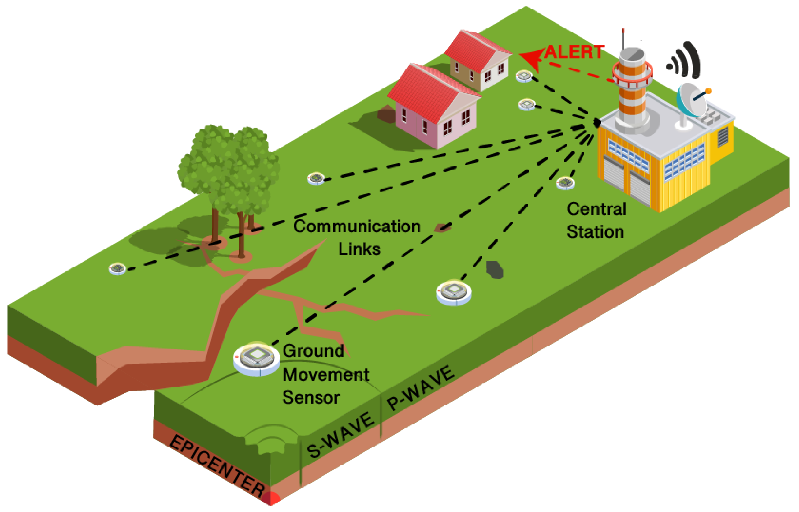
Figure: Internet of Things Solutions for Early Warning Systems: A Review (by 
 Marco Esposito ,Lorenzo Palma ,Alberto Belli ,Luisiana Sabbatini and Paola Pierleoni
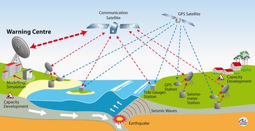
Technical concept of GITEWS 

|

Please Support Research projects :
Seeking partnerships, collaboration, and support from international donor agencies, global climate foundations, glocal R&D organizations, and global multi-national enterprises to provide financial support for conducting extensive research, robust EWS system design, IT programming, and AI system development.
The Multi-hazard Early Warning System Design & Implementation Center (MHEWC) www.mhewc.org engaged in Research and Development (R&D) to develop L&D assessment tools to quantify the ground-level elements impacted by disasters using GIS, RS (SAR image) & GPS tools, and UAV (drone, aerial photographs) captured elements to compare pre- & post-disaster impact levels and develop a strategy on how to minimize L&Ds. Please finance MHEWC to create the most advanced tools (GIS, RS, GPS, drone/UAV-captured elements, repository database queried by Artificial Intelligence) to support the sector department in minimizing L&Ds.
R&D on hazard detection, automated public alerts, command & control systems on emergency preparedness, evacuation deployment for lifesaving, extent of areas and L&Ds elements, and overall combat readiness(inclusive social participatory dynamics) for addressing multi-hazards, disaster threats, and emergencies.
Pleading for funds from climate funding windows, foundations, multinational companies-led CSRs, the UN, and INGOs, etc., please provide funds to carry out much-needed R&D to detect threats of impending dangerous weather events, instrumentalize the EOC/Command & control room with robust multi-hazard early warning systems, and enhance the hazard-combat readiness of inclusive social-participatory dynamics forces to combat disasters.
Seeking funds for establishing a big complex of the Multi-hazard Early Warning System Design & Implementation Center (MHEWC)
Research Projects, Strategic Partnerships and Financing Opportunities
Advancing Technology-Enabled Multi-Hazard Early Warning, Loss-and-Damage Assessment and Disaster Preparedness in the Global South
The Multi-Hazard Early Warning System Design & Implementation Center (MHEWC) (www.mhewc.org) is seeking strategic partnerships, technical collaboration and financial support from international donor agencies, multilateral development banks, United Nations organizations, global climate funds, philanthropic foundations, research institutions, universities, technology companies, space agencies and multinational enterprises.
The proposed partnerships will support extensive research, innovative early-warning-system design, geospatial analysis, information-technology programming, artificial-intelligence development, prototype testing and country-level demonstration of advanced tools for climate- and disaster-risk management.
MHEWC particularly seeks collaboration with institutions committed to strengthening the technological and operational capabilities of countries in the Global South, where inadequate observation networks, fragmented risk information, limited technical infrastructure and persistent last-mile communication gaps continue to undermine disaster preparedness and early action.
The proposed research portfolio comprises five interconnected programmes:
- AI-enabled disaster Loss and Damage assessment;
- Precision hazard detection and multi-hazard monitoring;
- Automated public alerting and last-mile warning;
- Technology-enabled EOCs, Situation Rooms and decision-support systems; and
- Inclusive whole-of-society preparedness and operational readiness.
Research Project 1: AI-Enabled Geospatial Loss and Damage Assessment System
Project purpose
MHEWC proposes to research, design and develop an integrated AI-Enabled Geospatial Loss and Damage Assessment System capable of identifying, mapping, classifying and quantifying elements affected by disasters.
The system will combine:
Geographic Information Systems—GIS;
Remote sensing;
Synthetic Aperture Radar—SAR imagery;
High-resolution optical satellite imagery;
Global Navigation Satellite Systems and GPS;
Unmanned Aerial Vehicles and drones;
Aerial photography;
Mobile field-survey applications;
Ground-based observations;
Sectoral administrative databases;
Artificial intelligence and machine learning; and
Centralized geospatial and attribute databases.
The proposed system will compare pre-disaster baseline conditions with post-disaster satellite, drone and field observations to determine what has been damaged, where the damage has occurred, the severity and spatial extent of the impact, and the populations and economic sectors affected.
Elements to be assessed
The system should support the assessment of impacts on:
People, households and communities;
Housing and human settlements;
Roads, bridges, railways, airports and ports;
Schools, hospitals and public buildings;
Water-supply and sanitation infrastructure;
Electricity and telecommunications networks;
Dams, embankments, drainage and irrigation systems;
Agricultural land, crops, fisheries and livestock;
Commercial and industrial facilities;
Forests, wetlands, rivers, coastal zones and ecosystems;
Cultural heritage;
Community assets and public services;
Livelihoods and employment;
Internally displaced populations; and
Vulnerable groups, including women, children, older persons and persons with disabilities.
Assessment dimensions
The proposed tools should measure:
Direct physical damage;
Direct and indirect economic losses;
Service interruption;
Livelihood losses;
Environmental damage;
Ecosystem-service losses;
Non-economic Loss and Damage;
Population displacement;
Recovery and reconstruction requirements;
Changes in vulnerability; and
Long-term development consequences.
Technical components
Pre-disaster baseline repository
A national or subnational geospatial repository should be developed containing:
Building footprints;
Population distribution;
Critical infrastructure;
Land use and land cover;
Agricultural production;
Ecosystem assets;
Public facilities;
Hazard zones;
Historical disaster impacts;
Social and economic indicators; and
Administrative and sectoral boundaries.
Post-disaster change detection
AI-assisted change-detection algorithms should compare pre- and post-event information to identify:
Flooded areas;
Damaged or destroyed buildings;
Disrupted roads and bridges;
Landslides and debris;
Crop damage;
coastline and riverbank changes;
Burned areas;
damaged utility networks;
inaccessible communities; and
changes in settlement and displacement patterns.
Field verification
Mobile applications and GPS-enabled survey tools should enable field teams to:
Record affected assets;
Capture geotagged photographs and videos;
Classify damage severity;
Verify satellite-derived observations;
Record household and livelihood impacts;
Work offline where connectivity is unavailable; and
Synchronize results with the central database.
AI-queryable risk repository
A controlled AI interface should allow authorized users to ask questions such as:
How many people are located within the affected flood zone?
Which hospitals and schools are inaccessible?
How many kilometres of road may have been damaged?
Which agricultural areas have experienced severe crop loss?
Which communities have not yet been assessed?
What are the estimated sectoral losses?
Which locations require immediate field verification?
What recovery interventions should be prioritized?
AI-generated outputs should remain traceable to verified source data and include uncertainty levels. Final official Loss and Damage figures must be validated by the responsible sector authorities.
Expected outputs
Standardized Loss and Damage assessment methodology;
National exposure and asset database structure;
GIS-based assessment platform;
AI-assisted satellite and UAV change-detection models;
Mobile assessment applications;
Sector-specific assessment templates;
Automated maps, tables and situation reports;
Decision-support dashboards;
Post-Disaster Needs Assessment support tools;
Loss-and-Damage indicator framework;
Training packages; and
Pilot demonstrations in selected hazard-prone locations.
Long-term outcome
The system will enable governments and sector agencies to move from delayed, fragmented and largely manual assessments toward rapid, consistent, geospatially precise and evidence-based measurement of disaster impacts. The resulting evidence can inform emergency assistance, anticipatory action, recovery planning, reconstruction, risk financing, insurance, Loss and Damage funding proposals and long-term risk-reduction investment.
Research Project 2: Precision Multi-Hazard Detection and Monitoring
MHEWC seeks financing for research and development of an integrated system capable of detecting, tracking and characterizing emerging hazards through the fusion of atmospheric, hydrological, geological, oceanographic, environmental and community-based observations.
Priority research areas
AI-assisted satellite-data interpretation;
Weather-radar and satellite integration;
Automated weather-station networks;
Lightning-detection systems;
River, rainfall and flood-level monitoring;
Soil-moisture and landslide sensors;
Coastal tide and storm-surge monitoring;
Wildfire and thermal-anomaly detection;
Air-quality and hazardous-emission monitoring;
Seismic and ground-deformation monitoring;
Drone-based rapid reconnaissance;
Crowdsourced and community-based observations;
Automated anomaly detection;
Multi-sensor data fusion; and
Compound and cascading-hazard analysis.
Hazards to be addressed
The research will initially focus on:
Severe thunderstorms;
Extreme rainfall;
Flash, riverine and urban flooding;
Tropical cyclones;
Coastal inundation and storm surge;
Lightning, hail and damaging winds;
Drought and heatwaves;
Landslides;
Wildfires;
Earthquakes and tsunamis;
Volcanic hazards;
Air pollution;
Epidemics;
Industrial and technological emergencies; and
Compound and cascading disaster risks.
Precision-monitoring objectives
The proposed system should progressively determine:
What hazard is developing;
Where it is developing;
How quickly it is intensifying;
Where and when it may have an impact;
How severe the event could become;
Which populations and assets are exposed;
What consequences are likely; and
What actions should be initiated before impact.
Expected outputs
Multi-hazard monitoring architecture;
Integrated observation-data platform;
AI-assisted anomaly-detection models;
Hazard-specific threshold models;
Real-time dashboards;
Forecast and observation integration tools;
Automated hazard maps;
Impact-estimation algorithms;
Pilot warning services; and
Operational guidance for national institutions.
Research Project 3: Automated Public Alerting and Last-Mile Warning System
MHEWC proposes to develop an inclusive, interoperable and multi-channel public-alerting system that can transform authorized technical warnings into clear, targeted and actionable messages.
Proposed system functions
The platform should:
Receive official warnings from authorized agencies;
Identify the geographic area at risk;
Link the warning to population and exposure information;
Generate standardized warning messages;
Translate messages into national and local languages;
Include hazard, severity, timing, location, likely impact and required action;
Disseminate warnings simultaneously through multiple channels;
Record when and where messages were transmitted;
Track delivery and acknowledgment where technically possible;
Collect feedback from communities; and
identify locations where warnings were not received.
Warning channels
Cell broadcast;
SMS;
Smartphone applications;
Radio and television;
Social-media platforms;
Websites and email;
Sirens and public-address systems;
Satellite communication;
Digital roadside displays;
Community volunteers;
Local-government networks;
Religious and traditional institutions; and
Accessible formats for persons with hearing, visual, intellectual or mobility-related disabilities.
Research areas
Common Alerting Protocol integration;
Geographically targeted alerts;
Automated multilingual translation;
AI-assisted message simplification;
Warning-message personalization;
Warning verification and approval workflows;
False-alarm reduction;
Delivery confirmation;
Telecommunication redundancy;
Community trust and behavioral response;
Protection against misinformation; and
Performance measurement at the last mile.
The system must preserve human and institutional authority. AI may help prepare, translate and route messages, but authorized institutions must retain responsibility for approving high-consequence public warnings.
Research Project 4: Technology-Enabled National Situation Room and EOC
MHEWC seeks support to design and pilot an integrated, ICT- and AI-enabled National Situation Room and Emergency Operations Centre capable of continuous multi-hazard monitoring, decision support, warning coordination and emergency management.
Proposed capabilities
Continuous hazard and threat monitoring;
Centralized climate and disaster-risk repository;
Real-time GIS and geospatial visualization;
Satellite, radar and sensor-data integration;
Impact-based forecasting;
AI-assisted anomaly detection;
Automated threshold monitoring;
Incident reporting and verification;
Common Operational Picture;
Emergency activation workflows;
Decision, task and resource tracking;
Evacuation planning;
Shelter and safe-route management;
Emergency logistics;
Public-warning coordination;
Situation-report generation;
Loss-and-damage tracking;
Recovery monitoring; and
National–subnational EOC networking.
Proposed ICT architecture
The platform should incorporate:
Enterprise GIS;
Spatial and attribute databases;
Data warehouse or data lake;
API gateway;
Sensor-integration platform;
Incident-management application;
AI and machine-learning services;
Decision-support dashboards;
Document and knowledge-management systems;
Mobile field applications;
Secure video conferencing;
Radio and satellite communications;
Backup power and connectivity;
Cybersecurity controls; and
A geographically separate disaster-recovery facility.
Emergency preparedness and evacuation deployment
The system should support:
Identification of populations requiring evacuation;
Estimation of evacuation time;
Selection of safe routes;
Mapping of shelters and available capacity;
Assignment of transportation;
Deployment of search-and-rescue teams;
Pre-positioning of food, water, medicines and emergency supplies;
Tracking of evacuation progress;
Identification of communities that remain at risk; and
Monitoring of shelter conditions and essential services.
Research Project 5: Inclusive Whole-of-Society Disaster Preparedness
Technology alone cannot create an effective early-warning system. MHEWC therefore proposes research and field experimentation on the institutional, social and behavioral conditions required to transform warning information into timely protective action.
The phrase “hazard-combat readiness” should be understood as comprehensive preparedness and operational readiness to confront severe disaster threats—not as militarization of disaster management.
Research themes
Public understanding of warning messages;
Community trust in warning authorities;
Household preparedness;
Community evacuation behavior;
Gender-responsive early warning;
Disability-inclusive communication;
Protection of children and older persons;
Local volunteer networks;
Indigenous and local knowledge;
Youth participation;
Private-sector preparedness;
School and hospital readiness;
Local-government emergency capacity;
Community-based observation;
Social-media information verification;
Risk perception and behavioral change; and
Simulation and exercise methodology.
Whole-of-society operational network
The research should develop a nested preparedness system connecting:
National government;
Sector ministries;
Technical agencies;
Subnational and local governments;
Emergency services;
Humanitarian organizations;
Private companies;
Mobile-network operators;
Universities;
Civil-society organizations;
Women’s and disability organizations;
Community leaders;
Households; and
Individuals.
Expected outputs
Inclusive warning-communication framework;
Community preparedness guidelines;
Local emergency and evacuation protocols;
Volunteer training packages;
School and hospital preparedness modules;
Gender and disability inclusion standards;
Simulation and exercise toolkits;
Community feedback mechanisms; and
Readiness-assessment indicators.
Establishment of the MHEWC Research and Innovation Complex
MHEWC seeks catalytic investment for the establishment of a permanent Multi-Hazard Early Warning System Research, Design and Implementation Complex.
The proposed complex would function as an international centre of excellence supporting research, prototype development, technical training, system demonstration and country-level assistance, particularly for climate-vulnerable and disaster-prone countries in the Global South.
Proposed facilities
Climate and Multi-Hazard Risk Intelligence Centre
A centre for integrating atmospheric, hydrological, geological, environmental, socioeconomic and geospatial risk information.
GIS, Remote Sensing and UAV Laboratory
A laboratory for satellite-image processing, SAR analysis, drone surveys, disaster mapping, exposure assessment and post-disaster change detection.
Artificial Intelligence and Data Science Laboratory
A secure computing environment for AI development, machine learning, database programming, predictive modelling, automated classification and risk analytics.
Early-Warning Systems Engineering Laboratory
A facility for designing, testing and integrating sensors, telemetry, sirens, communication systems, public-alerting technology and field monitoring equipment.
EOC and Situation Room Simulation Centre
A fully instrumented emergency-coordination environment where countries can test Common Operational Pictures, activation protocols, evacuation planning, incident management and emergency communication.
Climate-Risk Repository and Data Centre
A resilient data infrastructure for storing hazard, exposure, vulnerability, impact, Loss and Damage, early-warning and emergency-management data.
Drone and Aerial Observation Unit
A facility for UAV operation, sensor testing, pilot training, emergency reconnaissance and post-disaster assessment.
Training and Capacity-Development Academy
A specialized academy for government officials, NMHS personnel, emergency managers, GIS analysts, ICT professionals, humanitarian practitioners and community organizations.
Innovation and Prototype Workshop
A technical space for assembling, testing and improving low-cost sensors, communication devices, field equipment and early-warning prototypes.
International Collaboration and Conference Centre
A platform for research exchanges, technical workshops, policy dialogue, innovation challenges and joint project development.
Funding requirements
MHEWC invites financing for:
Land acquisition and construction of the proposed complex;
Laboratory and Situation Room equipment;
High-performance computing and data-storage infrastructure;
Satellite and remote-sensing data;
GIS and database development;
AI research and programming;
Sensor and communication-system prototyping;
Drone and aerial-survey equipment;
Software development;
Pilot projects and country demonstrations;
Research personnel and technical experts;
Fellowships and academic partnerships;
Training and simulation exercises;
Cybersecurity and backup infrastructure;
Community-based research; and
Long-term operation and maintenance.
Partnership modalities
Potential partners may support MHEWC through:
Research grants;
Climate and disaster-risk financing;
Corporate social-responsibility funding;
Technology donations;
Software, satellite-data and cloud-service credits;
Joint research programmes;
University partnerships;
Sponsored laboratories;
Equipment grants;
Expert secondments;
Fellowship programmes;
Challenge funds and innovation competitions;
Country-level demonstration projects;
Public–private partnerships; and
Endowment or institutional-development support.
Potential partnership institutions include:
United Nations organizations;
Multilateral development banks;
Bilateral development agencies;
Global climate funds;
Humanitarian donors;
Philanthropic foundations;
Space and satellite agencies;
Universities and research centres;
Telecommunications companies;
Geospatial and technology companies;
Insurance and risk-financing institutions;
International NGOs; and
Multinational corporations with climate, technology or humanitarian CSR programmes.
Call for strategic investment
MHEWC respectfully calls upon international donors, climate-finance institutions, philanthropic foundations, United Nations organizations, multinational companies, research institutions and technology partners to invest in this urgently needed research agenda.
This request should not be considered merely as a request to purchase equipment or construct a physical facility. It is an invitation to help establish a globally relevant research and innovation capability that can translate scientific knowledge, geospatial intelligence, artificial intelligence, advanced observation and community participation into practical systems for saving lives and reducing disaster Loss and Damage.
Supporting MHEWC will contribute to the development of advanced but locally applicable technologies for countries that face severe climate and multi-hazard risks while possessing limited institutional, technical and financial capacity. The proposed investment will help governments and communities move from reactive disaster response toward risk-informed prevention, precision warning, anticipatory action, operational preparedness and resilient recovery.
MHEWC welcomes global partners to jointly design, finance, test and scale these innovations under a Whole-of-Earth, Whole-of-Society framework for collective climate security and planetary de-risking.