AI-Driven Supercomputing Hub for Atmospheric Data Processing, Weather Forecasting, and Multi-Hazard Early Warning
[ The copyright © 2026 Z M Sajjadul Islam, Advisor, Multi-Hazard Early Warning System Design and Implementation Center (MHEWC – www.mhewc.org ). All rights reserved. Any material quoted, reproduced, adapted, or extracted from this proposal must be properly cited and attributed to the author. Please call at +8801711979179, Email: zmsajjad@gmail.com ]
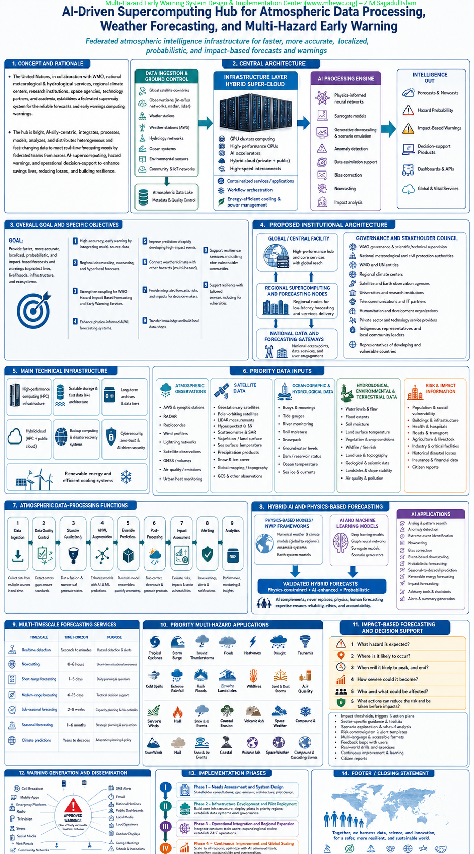
An AI-driven supercomputing data hub for atmospheric data processing represents a paradigm shift from traditional Numerical Weather Prediction (NWP) centers to dynamic Digital Twin ecosystems. Rather than relying purely on monolithic supercomputers to grind through complex, physics-based equations, these modern hubs leverage massive arrays of GPUs and cloud-native architecture to process atmospheric telemetry at unprecedented speeds.
Central Architecture
Moving from raw compute to actionable intelligence, these hubs are built on three foundational layers:
a) Infrastructure Layer (Hybrid Super-Cloud): Modern atmospheric hubs move away from CPU-heavy clusters toward GPU-dense computing (e.g., NVIDIA H100s or Grace Blackwell superchips). This provides the extreme parallel processing required to train and execute large-scale models, including Physics-Informed Neural Networks (PINNs), while utilizing AI to optimize the facility’s own energy management and cooling workloads.
b) Data Ingestion & Ground Control: The hub functions as an advanced ground control center to manage satellite constellations directly. By utilizing cloud-optimized object storage (like Zarr or ARCO), it bypasses the latency of traditional tape storage. This allows the system to instantly ingest high-speed atmospheric data including multi-modal feeds from hyperspectral sensors and edge AI telemetry. Furthermore, these unified data lakes seamlessly merge space-based telemetry with ground-truth vulnerability assessments gathered via CAPI (Computer-Assisted Personal Interviewing) platforms, ensuring hazard models reflect real-world exposure.
c) AI Processing Engine: The processing shifts from calculating physical equations step-by-step to leveraging learned patterns. Surrogate models replace computationally expensive physics steps (like radiative transfer), running up to 10,000 times faster. Simultaneously, generative super-resolution downscales coarse global data into hyper-local forecasts in a matter of seconds.
Accelerating Multi-Hazard Detection : This architecture fundamentally transforms Multi-Hazard Early Warning Systems (MHEWS). By automating sensor fusion and drastically reducing model runtime, the hub shifts forecasting from a static output to an interactive process. Decision-makers can run real-time “what-if” climate scenarios, expanding warning lead times and turning massive, unstructured data into immediate, actionable intelligence for early action protocols.

d)The Data Layer (Unified Data Lake)
The “Hub” functions as a central repository that ingests diverse data streams without the latency of tape storage.
- Object Storage: Data is stored in cloud-optimized formats (e.g., Zarr, ARCO) rather than traditional GRIB/NetCDF files on tape, allowing for parallel access by AI training pipelines.
- Multi-Modal Ingestion: The hub ingests data not just from satellites and radar, but also from non-traditional sources like IoT sensors, drones, and even social media for disaster impact assessment (Boukabara et al., 2021).
- ECMWF’s Object Store: The European Centre for Medium-Range Weather Forecasts (ECMWF) developed the Fields Database (FDB5), an object-based store that allows model output to be post-processed “on the fly” in memory, bypassing slow disk I/O (ECMWF, 2021).
e) The AI Layer (The “Engine”)
This is where the processing shifts from physical equations to learned patterns.
- Surrogate Models: AI models (emulators) replace computationally expensive parts of the physics model (e.g., radiative transfer). These run up to 10,000 times faster than traditional methods (Tao et al., 2024).
- Generative Super-Resolution: Generative AI is used to “downscale” coarse global data into high-resolution local forecasts (e.g., 1km resolution), effectively hallucinating realistic details based on learned physics (Boukabara et al., 2021).
1.0 Concept and rationale
The United Nations, in collaboration with the World Meteorological Organization, national meteorological and hydrological services, regional climate centres, research institutions, satellite agencies, technology partners, and disaster-management authorities, should support the establishment of an AI-Driven Supercomputing Hub for Atmospheric Data Processing, Weather Forecasting, and Multi-Hazard Early Warning.
The hub would provide the high-performance computational, scientific, and data-management infrastructure required to ingest, quality-control, integrate, process, model, analyse, and distribute vast volumes of atmospheric and Earth-system data in near real time. It would transform raw observations into reliable forecasts, probabilistic risk information, impact-based warnings, and operational decision-support products.
The proposed hub should be designed as a federated system, connecting a central or global facility with regional computing centres and nationally controlled data gateways. It should strengthen—not replace—the mandates and operational responsibilities of national meteorological and hydrological services and legally authorized warning agencies.
The system should align with existing international architecture:
- The WMO Integrated Global Observing System provides the overarching framework for integrating surface- and space-based observations.
- The WMO Information System 2.0, operational since January 2025, facilitates international exchange and discovery of weather, climate, water, and related Earth-system data.
- The WMO Integrated Processing and Prediction System connects operational centres that produce and exchange weather, climate, water, and environmental prediction products.
- The WMO Unified Data Policy provides a framework for exchanging Earth-system data among WMO Members.
- The Common Alerting Protocol provides a standardized format for communicating authoritative alerts through multiple media and communication channels.
These systems provide an institutional foundation with which the proposed hub should interoperate. WIGOS, WIS 2.0, WIPPS, WMO Unified Data Policy, and Common Alerting Protocol.
2.0 Overall goal
The overall goal would be to establish a secure, interoperable, high-performance, and AI-enabled atmospheric intelligence infrastructure capable of producing faster, more accurate, localized, probabilistic, and impact-oriented forecasts and warnings for climate-related and multi-hazard emergencies.
2.1 Specific objectives
The hub should:
- Establish a high-capacity computing environment for atmospheric modelling, Earth-system simulation, ensemble prediction, AI-based forecasting, and climate-risk analysis.
- Integrate real-time observations from terrestrial, marine, airborne, satellite, radar, hydrological, environmental, and community-based monitoring systems.
- Strengthen national and regional capacity for numerical weather prediction, nowcasting, forecast downscaling, data assimilation, impact-based forecasting, and climate modelling.
- Develop hybrid forecasting systems that combine physics-based numerical models with artificial intelligence and machine-learning models.
- Improve the prediction and early detection of rapidly developing and high-impact hazards, particularly in countries with limited computational and technical capacity.
- Convert hazard forecasts into location-specific information about exposed populations, infrastructure, livelihoods, ecosystems, and essential services.
- provide interoperable forecast products, geospatial data services, application programming interfaces, dashboards, and standardized warning messages.
- Strengthen international and transboundary exchange of atmospheric, hydrological, oceanographic, environmental, and hazard information.
- Provide research, testing, validation, training, and computational support to developing countries, least developed countries, small island developing states, and fragile or conflict-affected countries.
- Maintain transparent human oversight over AI-supported forecasting, warning, and operational decision-making.
3.0 Proposed institutional architecture
The hub should operate through a multi-level, federated architecture.
3.1 Global or central facility
The central facility would maintain the principal supercomputing, global modelling, data-archiving, research, interoperability, and system-coordination capabilities. It would process global datasets, operate selected global Earth-system and AI models, maintain common technical standards, and provide computational services to regional and national partners.
3.2 Regional supercomputing and forecasting nodes
Regional nodes would run high-resolution regional models, generate transboundary forecasts, provide specialized hazard services, and support countries sharing common climatic and geographical systems, such as river basins, cyclone regions, monsoon systems, drought corridors, mountain ranges, and coastal zones.
3.3 National data and forecasting gateways
National gateways would allow authorized institutions to contribute observations, receive global and regional products, run national forecasting applications, protect restricted national data, and produce legally authorized national warnings. National authorities would retain control over the approval and dissemination of public warnings.
3.4 Institutional governance
A governing council should include representatives of:
- National meteorological and hydrological services;
- National disaster-management and civil-protection authorities;
- WMO and relevant United Nations entities;
- Regional climate and forecasting centres;
- Satellite and Earth-observation agencies;
- Universities and atmospheric research institutions;
- Telecommunications and information-technology institutions;
- Humanitarian and development organizations;
- Infrastructure and essential-service providers;
- Data-protection, cybersecurity, and AI-governance specialists; and
- Representatives of developing and climate-vulnerable countries.
Scientific, technical, ethical, data-governance, and user-advisory committees should support the governing council.
4.0 Main technical infrastructure
4.1 High-performance computing system
The computing environment should include:
- High-capacity central processing units;
- Graphics processing units and other AI accelerators;
- High-speed interconnections between computing nodes;
- Parallel processing and workflow-orchestration systems;
- High-performance storage for operational modelling;
- Scalable object storage and atmospheric data lakes;
- Long-term archives for historical observations and model outputs;
- Cloud-computing and hybrid-cloud capabilities;
- Containerized scientific applications;
- Automated workload scheduling and resource allocation;
- Development, testing, research, and operational environments;
- Backup computing capacity at geographically separate locations; and
- Energy-efficient cooling, power-management, and renewable-energy systems.
Critical operational forecasting should not depend on a single facility. Primary and secondary computing centres should be geographically separated and capable of taking over essential services during power failures, cyber incidents, telecommunications disruptions, disasters, or equipment failure.
4.2 Atmospheric and Earth-system data lake
The hub should maintain a structured data lake containing:
- Raw observational data;
- Quality-controlled observations;
- Assimilation-ready datasets;
- Satellite and radar imagery;
- Numerical model initial conditions;
- Deterministic and ensemble forecasts;
- AI-ready training and validation datasets;
- Reanalysis and historical climate data;
- Hazard, exposure, vulnerability, and impact information;
- Forecast-verification records;
- Public-warning products;
- Model documentation and audit logs; and
- Long-term disaster, damage, loss, and recovery datasets.
Every dataset should include standardized metadata describing its origin, time, geographical coverage, processing history, quality, uncertainty, access restrictions, license, and responsible institution.
5.0 Priority data inputs
The hub should integrate data from the following: sorues
Atmospheric observations : Automatic weather stations; Synoptic and climatological stations; Rain gauges; Radiosondes and upper-air observing systems; Weather and wind-profiler radars; Lightning-detection networks; Aircraft-based observations; Ground-based Global Navigation Satellite System receivers; Atmospheric composition and air-quality stations; and Urban meteorological and heat-monitoring networks.
Satellite and remote-sensing observations
Data hub expected to have two data connectivity, a) direct satellite downlinks; Geostationary meteorological satellites; Polar-orbiting satellites; Low-Earth-orbit satellite constellations; Hyperspectral infrared and microwave sounders; Synthetic Aperture Radar; Optical and thermal infrared sensors; Satellite-based precipitation estimates; Soil-moisture and vegetation-monitoring products; Ocean-colour, sea-surface-temperature, and altimetry products; Snow, glacier, sea-ice, and cryosphere observations; and Global Navigation Satellite System radio-occultation data. b) API linkage with global meteorological data providers ( ECMWF, NOAA-CPC/CDO, IRI, JAXA, CMA, JMA etc) .
Oceanographic and coastal observations Ocean buoys; Tide gauges; Wave-monitoring systems; Ships and autonomous marine platforms; Coastal radars; Sea-level and storm-surge observations; and Ocean temperature, salinity, current, and wave data.
Hydrological, environmental, and terrestrial data River and reservoir levels; Streamflow and discharge; Soil moisture; Groundwater levels; Snowpack and glacier conditions; Land-surface temperature; Vegetation and crop conditions; Wildfire fuel and burn-condition data; Air-quality and atmospheric-pollution observations; and Land-use, topographic, geological, and ecosystem information.
Risk and impact information
Population distribution; Poverty and social-vulnerability indicators; Buildings and settlements; Roads, bridges, ports, and airports; Hospitals, schools, shelters, and public facilities; Electricity, water, sanitation, and telecommunications networks; Agricultural areas, livestock, fisheries, and food systems; Industrial facilities and hazardous installations; Historical disaster impacts and losses; Real-time humanitarian needs; and Community-generated and citizen-science reports.
Community and Internet of Things(IoT) observations should undergo automated and human quality control before being incorporated into authoritative products.
6.0 Atmospheric data-processing functions
The hub should perform:
- Data ingestion: Receive continuous observations through secure real-time feeds, message brokers, satellite links, terrestrial networks, and standardized APIs.
- Data quality control: Identify missing observations, duplicate records, physically inconsistent values, sensor drift, temporal discontinuities, spatial anomalies, and possible instrument failures.
- Data harmonization: Convert observations into standardized coordinates, units, timestamps, formats, and metadata structures.
- Data assimilation: Combine recent observations with previous forecasts to produce the best possible estimate of the current atmospheric and Earth-system state.
- Model initialization: Generate the initial atmospheric, oceanic, land-surface, hydrological, wave, and environmental conditions needed for forecast models.
- Forecast production: Run deterministic, ensemble, coupled Earth-system, regional, local, hydrological, coastal, and atmospheric-composition models.
- Post-processing: Correct systematic biases, calibrate probabilities, improve spatial resolution, derive hazard indicators, and translate technical model variables into operational forecast products.
- Verification: Compare forecasts with observations and impacts to measure forecast accuracy, reliability, lead time, false alarms, missed events, spatial accuracy, and user relevance.
- Archiving: Preserve observations, forecasts, warnings, model versions, decisions, and verification results for research, accountability, training, and system improvement.
7.0 Hybrid AI and physics-based forecasting
Artificial intelligence should complement physics-based numerical weather prediction rather than automatically replacing it. The architecture should allow AI and conventional models to operate independently, jointly, and in parallel so that their outputs can be compared and validated.
This approach is consistent with operational developments at ECMWF, where its machine-learning-based Artificial Intelligence Forecasting System operates alongside the traditional physics-based Integrated Forecasting System, including deterministic and ensemble configurations. This suggests that an operational hub should maintain hybrid and parallel forecasting capabilities rather than rely exclusively on one modelling approach. ECMWF forecasting systems and operational AI ensemble forecasting.
AI and machine learning could support: Automated quality control and sensor-failure detection; Identification of atmospheric anomalies; Satellite and radar image interpretation; Precipitation and thunderstorm nowcasting; Tropical-cyclone detection and tracking; Forecast bias correction; Statistical downscaling and super-resolution; Ensemble calibration; Rapid emulation of computationally expensive model components; Wildfire, smoke, dust, and volcanic-ash detection; Flood-inundation and landslide-trigger estimation; Heatwave and drought anomaly detection; Forecast-impact estimation; Automatic generation of maps and technical summaries; Multilingual preparation of draft warning messages; Detection of inconsistencies among observations and forecast systems; and Continuous learning from forecast-verification and post-disaster impact data. AI-generated outputs should always include information about the model used, training data, forecast time, geographical domain, confidence, uncertainty, known limitations, and validation status.
7.1 Multi-timescale forecasting services
The hub should support a seamless forecasting system covering:
Forecasting service | Indicative horizon | Principal use |
Real-time detection | Seconds to minutes | Lightning, radar echoes, earthquakes, sensor anomalies and rapidly emerging threats |
Nowcasting | Approximately 0–6 hours | Thunderstorms, extreme rainfall, flash floods, hail, damaging winds and urban flooding |
Short-range forecasting | Approximately 1–3 days | Cyclones, severe weather, floods, heat, marine hazards and emergency preparedness |
Medium-range forecasting | Approximately 3–15 days | Probabilistic preparedness, anticipatory action and resource pre-positioning |
Sub-seasonal forecasting | Approximately 2–8 weeks | Heat, drought, rainfall anomalies, agriculture, health and humanitarian planning |
Seasonal forecasting | One or more seasons | Water, agriculture, energy, food security and contingency planning |
Climate projections | Years to decades | Adaptation planning, infrastructure design and long-term climate-risk management |
Forecast horizons should be adapted to the predictability of each hazard and the decisions required by users.
7.2 Priority multi-hazard applications
The hub should support forecasting and risk analysis for: Tropical cyclones and storm surges; Severe thunderstorms and mesoscale convective systems;Lightning, hail, tornadoes, and damaging winds; Extreme rainfall and flash flooding; Riverine, coastal, and urban flooding; Heatwaves and extreme-temperature events; Drought, water scarcity, and agricultural stress; Wildfires, smoke, and air-quality emergencies; Landslides and debris flows; Snowstorms, avalanches, and extreme cold; Sandstorms and dust storms; Marine and coastal hazards; Volcanic ash and atmospheric dispersion; Disease and health risks influenced by weather and climate; Compound and cascading hazards; and Transboundary weather, water, climate, and environmental emergencies.
7.3. Impact-based forecasting and decision support
The hub should move beyond predicting atmospheric conditions to identifying their potential consequences. Hazard forecasts should be integrated with exposure, vulnerability, and coping-capacity information to answer six operational questions:
- What hazard is expected?
- Where is it likely to occur?
- When will it begin, peak, and end?
- How severe could it become?
- Who and what could be affected?
- What protective actions should be taken before impact?
Decision-support products should include:Hazard-probability maps; Forecast rainfall and flood-inundation maps; Probable impact zones; Population and infrastructure exposure estimates; Location-specific risk levels; Evacuation and shelter-planning information; Possible disruption of roads and essential services; Agricultural and livelihood-impact outlooks; Trigger information for anticipatory action and forecast-based financing; Resource pre-positioning recommendations; Alternative operational scenarios; and Clearly communicated forecast confidence and uncertainty.
7.4. Warning generation and dissemination
The system should assist authorized forecasters in preparing standardized warning products. However, AI should not independently issue public warnings or order evacuations.
Final responsibility for warning approval, evacuation, emergency declarations, resource deployment, and other consequential actions must remain with legally authorized human decision-makers.
Approved warnings should be distributable through: Common Alerting Protocol feeds; National and regional warning portals; Emergency operations centres; Cell broadcast and location-based alerting; SMS and mobile applications; Radio and television; Satellite communication; Social-media platforms; Web services and dashboards; Sirens and community-warning systems; Humanitarian communication networks; and Accessible services for persons with disabilities.
Each warning should clearly communicate the hazard, affected area, timing, severity, probability, expected impacts, uncertainty, issuing authority, update time, expiration time, and recommended protective actions.
7.5 Research, innovation, and capacity development
The hub should include an atmospheric science and AI innovation laboratory through which universities, meteorological services, technology institutions, and researchers can: Develop and test new forecast models;Train AI models using curated atmospheric datasets; Evaluate emerging satellite and sensor technologies; Conduct forecast-sensitivity experiments; Develop country-specific downscaling systems; Build digital twins for selected hazards and regions; Test low-cost observation and communication technologies; Compare AI, physics-based, and hybrid forecasts; Develop open-source forecasting applications; and Undertake joint research on compound and cascading hazards.
Developing countries should receive secure access to computing resources, shared modelling environments, technical assistance, fellowships, training, model-development support, and operational mentoring. Capacity development should cover atmospheric science, meteorology, hydrology, oceanography, climate science, data engineering, high-performance computing, AI, GIS, cybersecurity, forecast communication, and impact-based warning services.
7.6 Proposed implementation phases
Phase I: Needs assessment and system design Assess national and regional forecasting capacities; Inventory existing observation networks and data systems; Identify priority hazards and operational users; Determine computing, storage, connectivity, and staffing requirements; Establish governance and data-sharing arrangements; Define technical standards and interoperability requirements; Prepare feasibility studies, safeguards, budgets, and procurement plans; and Select pilot regions and participating institutions.
Phase II: Infrastructure development and pilot operation Procure and install computing, storage, networking, and backup systems; Establish the atmospheric data lake; Connect priority observation and forecasting systems; Deploy data-assimilation and modelling workflows; Develop initial AI applications; Establish cybersecurity and operational-continuity systems; Train technical and operational personnel; and Pilot selected hazards in representative regions.
Phase III: Operational integration and regional expansion Begin round-the-clock operations; Connect additional national and regional centres; Expand high-resolution and ensemble forecasts; Integrate hazard, exposure, vulnerability, and impact databases; Operationalize impact-based forecasting; Connect CAP-compatible warning systems; Conduct independent system verification; and Establish service-level agreements with participating institutions.
Phase IV: Continuous improvement and global scaling Update hardware, software, AI models, and observation interfaces; Expand services to additional countries and hazards; Incorporate new satellite missions and sensor systems; Conduct regular model revalidation; Improve energy efficiency; Strengthen research partnerships; and Maintain long-term financing and institutional sustainability.
7.7 Key performance indicators
Performance should be measured through indicators suchs: Percentage of priority observations received within required time limits; Data completeness, reliability, and quality-control rates; Supercomputing availability and operational uptime; Forecast-production time; Improvement in forecast accuracy and useful lead time; Reliability of probabilistic forecasts; Reduction in missed events and false alarms; Number of national and regional systems connected; Number of hazards supported operationally; Percentage of warnings containing impact and protective-action information; Number of countries receiving computational and technical support; Number of trained forecasters, scientists, engineers, and emergency managers; CAP adoption and dissemination-channel coverage; User satisfaction among warning authorities and emergency services; System recovery time following disruptions; Energy consumed per forecast cycle; and Documented use of forecasts for anticipatory action, evacuation, preparedness, and emergency-resource deployment.
8.0 Recommendation
The proposed hub should be developed as a shared global public-interest infrastructure and an integrated network of interoperable centers, providing advanced computing and atmospheric intelligence to all participating countries while preserving national data sovereignty, institutional mandates, scientific integrity, and human authority over public warnings and emergency decisions. The initiative is expected to deliver: Faster processing of atmospheric and Earth-system observations; More accurate and localized weather forecasts; Improved prediction of rapidly developing extreme events; Longer and more useful warning lead times;Stronger probabilistic and ensemble forecasting; Better communication of forecast confidence and uncertainty; Wider availability of impact-based and action-oriented warnings; Reduced forecasting disparities between countries; Improved transboundary hazard monitoring; Stronger national meteorological and hydrological services; Improved support for anticipatory action and forecast-based financing; Better protection of lives, livelihoods, infrastructure, ecosystems, and development investments; Expanded research and innovation in atmospheric science and AI; and A more resilient global early-warning infrastructure.