Continuous Monitoring and Early Warning for Avalanche-Induced GLOF Originating in Tibet and Affecting the Nepal-China Border Corridor : A Multi-Sensor Framework Informed by the Nepal-China(Tibet) Border Disaster ( 26 August 2026) and Proposed Robust Early Warning System
The copyright © 2026 Z M Sajjadul Islam, Advisor, Multi-Hazard Early Warning System Design and Implementation Center (MHEWC – www.mhewc.org ). All rights reserved. Any material quoted, reproduced, adapted, or extracted from this proposal must be properly cited and attributed to the author. Please call at +8801711979179, Email: zmsajjad@gmail.com
Executive Summary
The catastrophic transboundary flood that struck the Nepal-Tibet border region on 26 August 2026 demonstrates the growing threat posed by cascading cryosphere hazards across the Hindu Kush Himalaya. Preliminary analysis of satellite imagery and hydrological and seismic observations indicates that a substantial mass of glacier ice, bedrock, rock debris and sediment detached from a high-elevation slope near Langtang Lirung and entered the Lhende Khola catchment, which drains into the Bhote Koshi River.
The resulting ice-rock avalanche may have temporarily obstructed the river, displaced a large volume of water or transformed directly into a fast-moving debris flow. This generated a destructive surge of water, mud, sediment and boulders that travelled through the Lhende Khola, Bhote Koshi and Trishuli river systems. However, the precise sequence of processes remains under scientific investigation. Possible mechanisms include the formation and sudden failure of a temporary river blockage, direct displacement of river water, rapid transformation of the avalanche into a debris flow or a combination of these processes. The evidence reviewed in this study does not currently establish the failure of a pre-existing glacial lake as the primary mechanism. Therefore, classification of the event as a conventional glacial lake outburst flood remains scientifically unconfirmed.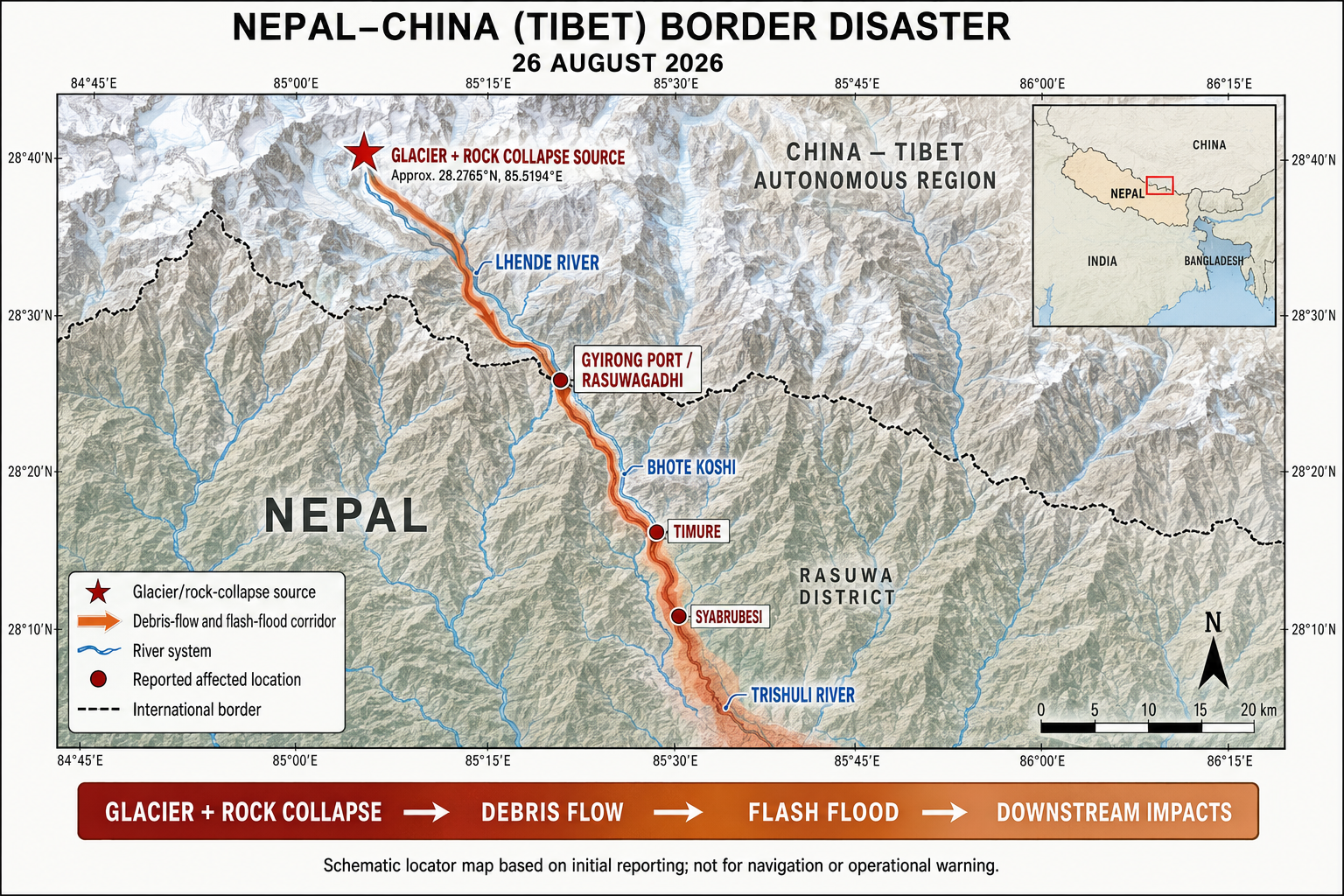
Initial situation reports available on 26 August 2026 confirmed at least 98 deaths, comprising 95 fatalities in Nepal and three in Tibet, China. Hundreds of people remained missing. Settlements, roads, bridges, border facilities, hydropower projects, electricity-transmission systems and hydrological monitoring stations sustained extensive damage. Search and rescue operations and the reconciliation of casualty lists were still continuing. All impact and casualty figures should therefore be treated as provisional and linked to the date of reporting. Associated Press | Reuters
The incident exposes a critical limitation in conventional flood and GLOF early-warning systems. These systems generally monitor rainfall, river levels and previously identified glacial lakes, but they may not detect the full progression of an avalanche-induced river-blockage event. Such a disaster can begin with the destabilization of a hanging glacier or a steep rock-and-ice slope, followed by avalanche initiation, river obstruction, rapid water accumulation, overtopping or failure of the temporary debris dam, and the release of a destructive downstream surge. The transformation from a high-mountain slope failure into a debris-laden flood can occur within minutes or hours. An effective early-warning system must therefore monitor and detect every stage of this cascading process, from source-area instability to downstream flood-wave propagation.
This study proposes a dedicated, multi-layered monitoring and early-warning framework integrating satellite observations, continuously operating ground sensors, automated cameras, artificial intelligence, hydrological and hydraulic models, resilient communication systems and community-based observations. No single monitoring instrument can reliably detect every stage of the hazard sequence. The proposed framework consequently applies multi-sensor detection and verification to identify source-area instability, avalanche initiation, river blockage, water accumulation, temporary-dam deformation, breach development and downstream flood-wave movement.
The first requirement is to identify, map and rank potential avalanche-source areas, hanging glaciers, unstable rock-and-ice slopes, narrow river gorges and probable blockage locations. Each location should be assessed according to the likelihood of river obstruction and the potential consequences for downstream settlements, infrastructure, services and economic activities.
Priority locations should be monitored through an automated, integrated and multi-sensor surveillance network. The system should combine multipurpose and mission-specific drones or UAVs, including autonomous platforms programmed to conduct hourly surveillance during elevated-risk periods, with optical and Synthetic Aperture Radar satellite imagery, satellite-based terrain-displacement analysis, seismic sensors, infrared sensors, geophones, infrasound instruments, Global Navigation Satellite System stations, tiltmeters, specialized crack- and displacement-monitoring sensors, ground-based radar, automatic weather stations, snow-monitoring instruments, and thermal and optical cameras.
Synthetic Aperture Radar is particularly valuable because it can detect surface displacement and other changes during darkness and through cloud cover. However, satellite revisit intervals, acquisition schedules, data-transmission requirements and processing delays may prevent the timely detection of rapidly evolving events. Satellite monitoring should therefore be integrated with continuously operating ground-based instruments and hourly or event-triggered autonomous drone surveillance to provide high-frequency observation, verification and operational continuity.
Thermal infrared, near-infrared and conventional optical cameras can provide continuous surveillance of unstable slopes, glacier fronts, impounded water, temporary natural dams, outlet channels and initial flood corridors. AI-assisted image analysis can delineate shorelines and waterlines, identify glacier and slope movement, detect avalanches and displacement waves, monitor cracks and outlet erosion, recognize overtopping, and estimate abnormal changes in lake or impoundment levels. Cameras should be installed on stable, elevated ground outside identified avalanche, displacement-wave, flood-inundation and debris-flow zones. Each installation should include weatherproof housing, backup power, lens-heating or lens-protection systems, and redundant radio, cellular and satellite communication pathways. Camera-based monitoring must not function as a stand-alone warning system. Fog, snowfall, lens icing, darkness, terrain obstruction and poor visibility can conceal critical changes. Thermal imagery also cannot independently detect internal erosion, seepage pathways or piping within a temporary debris dam. Camera observations should therefore be verified against lake- and river-level sensors, pressure transducers, discharge gauges, seismic and infrasound signals, ground-deformation instruments, satellite imagery, weather observations and reports from communities, security posts and infrastructure operators.
Every automated detection should include a time stamp, confidence score, data-quality indicator and identification of the supporting sensors. Critical alerts should normally be reviewed by trained operators. However, an extreme breach or downstream-surge signal confirmed simultaneously by multiple independent sensors should trigger immediate automated notification and warning actions under an approved standard operating procedure.
Why did it happen???
The disaster occurred through a cascading rock- ice collapse and river-blockage process, rather than a simple glacial lake suddenly bursting.
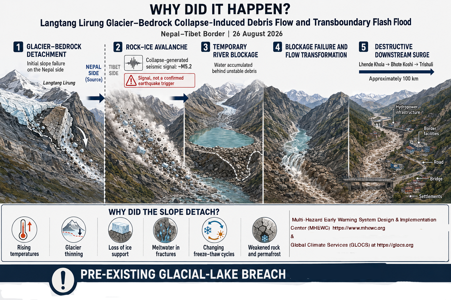
The best available evidence indicates that it was caused by a massive rock-slope collapse involving an overlying glacier, which rapidly transformed into an ice-rock avalanche, debris flow and catastrophic river flood.
The cascading sequence
A large section of bedrock failed
At approximately 8:37 a.m., an enormous mass of bedrock and overlying glacier detached near Langtang Lirung at an elevation of about 5,200 metres.
Rock and ice plunged into the valley
The mass fell approximately 1,200 metres, fragmented and accelerated down the extremely steep mountain slope. Satellite images subsequently revealed a major bedrock scar, indicating that this was primarily a rock-slope failure carrying glacier ice, rather than the collapse of glacier ice alone.
The avalanche entered the Lhende Khola
The avalanche incorporated ice, meltwater, river water, soil, sediment and boulders. This converted it into a highly mobile debris flow.
A temporary landslide dam may have formed
Debris appears to have temporarily blocked the Lhende Khola. Water accumulated behind the blockage and its sudden release probably intensified the downstream surge. However, scientists are still determining exactly how much floodwater came from river impoundment, glacier melt and other water stored within the mountain system.
The surge propagated through connected rivers
The flow travelled through the Lhende Khola, Bhote Koshi and Trishuli river system, reportedly reaching speeds approaching 150 kilometres per hour in its upper reaches. USGS estimates that the debris flow and flood travelled approximately 100 kilometres.
It was not triggered by an earthquake
The collapse produced seismic energy equivalent to approximately a magnitude 5.2 earthquake. Initial reports therefore interpreted the signal as an earthquake. Subsequent seismic and satellite analysis indicates that the mass movement generated the seismic signal – the earthquake did not trigger the collapse.
Why did the mountain slope fail?
The exact final destabilizing mechanism remains under investigation. Likely contributing conditions include: extremely steep and fractured Himalayan bedrock; glacier thinning and retreat, reducing the physical support previously provided to the slope; meltwater entering rock fractures and increasing internal water pressure; thawing mountain permafrost and weakening ice that binds fractured rock; repeated freezing and thawing; changing snow, rainfall and temperature patterns; and long-term geological instability in the Langtang region.
Climate change should therefore be understood as a probable risk multiplier and preconditioning influence, not yet as the scientifically proven sole trigger of this individual collapse. Rising temperatures can increase glacier melting, reduce ice support and destabilize frozen mountain slopes, making such cascading events more likely.
Why was it so catastrophic?
The collapse became a major disaster because several conditions combined: an exceptionally large volume of rock and ice failed; the mass fell through approximately 1,200 metres of vertical relief; narrow valleys concentrated and accelerated the flow; the avalanche continuously incorporated water, sediment and boulders; settlements, border facilities, roads, bridges and hydropower installations occupied the river corridor; the upper communities had only minutes to react; and monitoring stations and communications were damaged during the event.
At Galchhi, the Trishuli River reportedly rose by approximately nine metres within 30 minutes, demonstrating the exceptional magnitude and speed of the flood wave.
Why did early warning fail??
Regional and global Earth-observation and satellite-surveillance capabilities have advanced considerably in the modern era. Highly specialized drones and unmanned aerial vehicles are also now available for monitoring avalanche-source zones, glacier conditions and movement, glacier fronts, glacial-lake surfaces and water levels, surrounding unstable slopes, lake outlets, downstream channels, moraine and other natural dams, hydropower reservoirs and exposed infrastructure.
Despite these technological advances, access to the full capabilities of major satellite systems remains highly unequal. Why have their data, direct-tasking facilities, low-latency products, processing tools and operational services not been made readily accessible to all countries and responsible institutions, particularly those in least developed and developing countries? What are the principal satellite systems, what functions do they perform, who owns and operates them, and what financial, technical, licensing, security or commercial restrictions limit their use for real-time glacier, glacial-lake and GLOF monitoring?
We have the following satellite systems for tracking potential GLOF-hazardous elements, but these technologies remain insufficient for real-time GLOF detection.
Satellite/system | Principal monitoring function |
Sentinel-1 SAR | All-weather, day-and-night detection of lake-area changes, avalanches, slope failures, inundation and possible breach impacts |
Sentinel-2 | High-resolution monitoring of lake boundaries, ice cover, shoreline movement, glacier fronts, outlets and moraine dams |
Landsat 8 and 9 | Long-term analysis of glacial-lake expansion, glacier retreat and surface-temperature changes |
PlanetScope | Frequent 3–5 m imagery for rapid lake, glacier and outlet changes |
WorldView and Pléiades Neo | Sub-metre inspection of cracks, outlets, moraine dams, debris blockages and damaged infrastructure |
ICEYE, Capella and COSMO-SkyMed | Rapidly tasked, high-resolution SAR monitoring during cloud cover, darkness and severe weather |
ALOS-2/4 PALSAR | L-band SAR monitoring of terrain deformation, landslides, glaciers and flood impacts |
ICESat-2 | Precise elevation profiles of glacier surfaces and lake-water levels where satellite tracks intersect |
SWOT | Measurement of lake area and water-surface elevation, particularly for sufficiently large lakes |
GPM/IMERG | Satellite-based precipitation monitoring for assessing rainfall-related triggering conditions |
MODIS and VIIRS | Frequent regional monitoring of snow cover, glacier conditions, large lakes and downstream flooding |
An operational GLOF-monitoring system should not rely predominantly on expensive Doppler weather radar, high-cost remote-sensing infrastructure or satellite observations alone. Sentinel-1 SAR and Sentinel-2 optical imagery should form the core space-based monitoring layer, supplemented by high-resolution commercial imagery, ICESat-2 or SWOT observations, satellite rainfall products and automated change-detection algorithms.
Although Sentinel data are generally free and openly accessible, their effective operational use still depends on internet connectivity, data-processing capacity, technical expertise and product-delivery time. Direct satellite tasking, dedicated downlink services, very-high-resolution imagery and low-latency processed products are often governed by proprietary protocols and commercial arrangements. Many least developed and developing countries have limited access to these services and may lack the infrastructure required to receive, process and interpret the data rapidly.
Satellite observations are constrained by orbital revisit intervals, acquisition and tasking schedules, cloud cover affecting optical imagery, terrain-related distortion and shadowing in radar imagery, data-processing latency, and the time required to transmit actionable products to responsible institutions. Although ICESat-2 and SWOT provide valuable measurements, their track coverage and revisit characteristics do not allow continuous monitoring of every glacial lake. Satellite systems are therefore indispensable for regional surveillance, baseline mapping, long-term change detection, prioritization of high-risk lakes and post-event verification, but they cannot independently provide reliable minute-scale detection and warning of a sudden lake breach or rapidly developing glacial lake outburst flood.
Excessive dependence on externally operated satellite systems may also create operational dependencies related to mission priorities, acquisition schedules, tasking arrangements, data-access procedures, specialized processing capabilities and delays in converting satellite observations into actionable warnings. A complementary, nationally owned monitoring capability should therefore be developed using purpose-built, multi-sensor drones and unmanned aerial vehicles. These platforms can be procured, operated and maintained nationally and deployed for targeted, high-frequency surveillance of priority glacial lakes, unstable slopes, outlet channels and potential river blockages. Equipped with optical, thermal infrared, multispectral, LiDAR and other appropriate sensors, drones can provide more frequent local observations and rapid verification during periods of elevated risk. However, because their operation may be constrained by severe weather, high-altitude conditions, battery endurance, communications, airspace requirements and flight safety, they should form part of an integrated monitoring system combining satellites, ground-based sensors, automated cameras, seismic and infrasound instruments, river gauges, telemetry and community observations.
Apparent Community-Level Failure of the End-to-End Early Warning System During the 26 August 2026 Nepal-Tibet Flash Flood
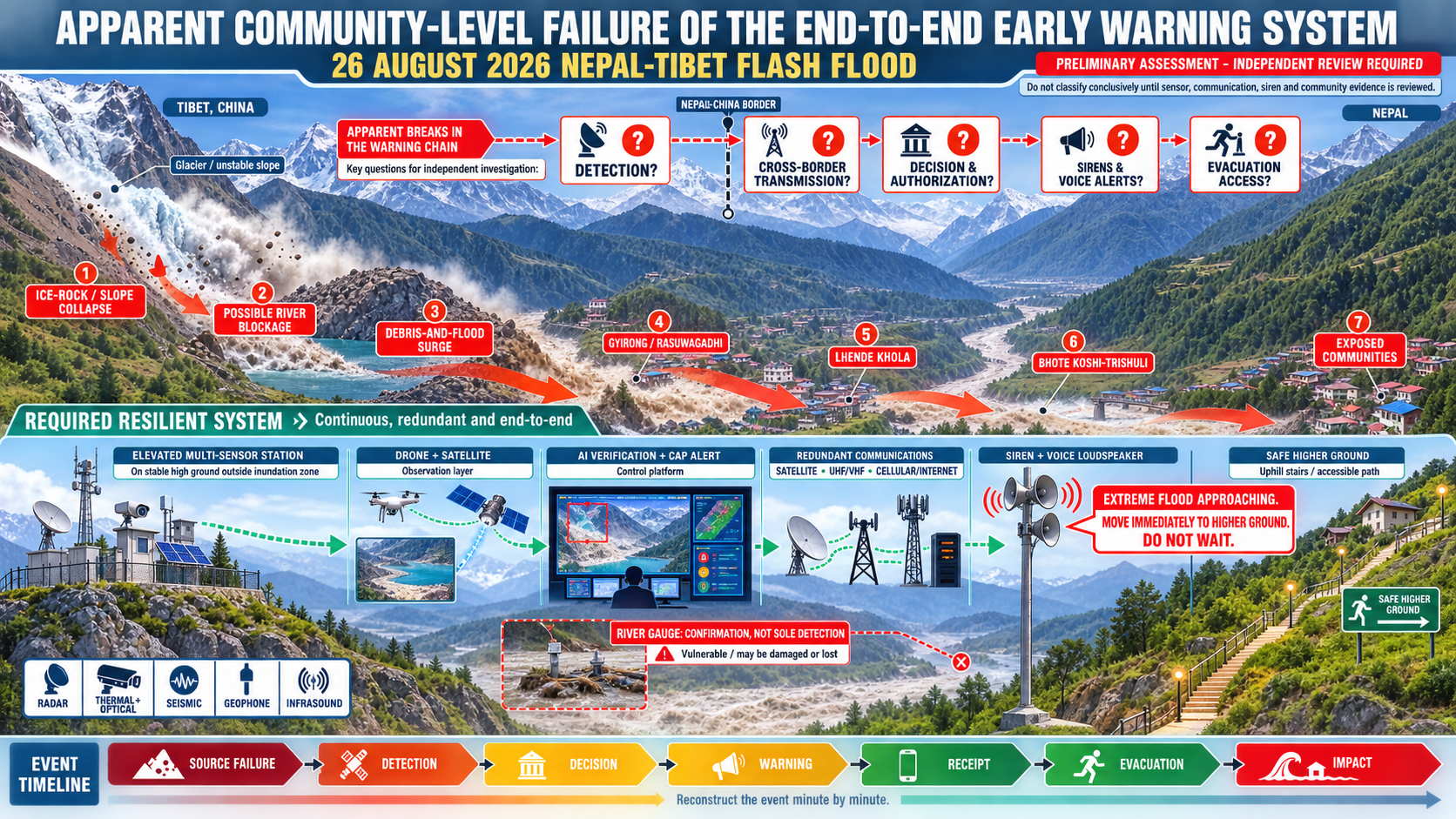
The catastrophic consequences of this extremely rapid-onset disaster point to potentially serious systemic failures in disaster risk governance, institutional accountability, technology deployment, risk communication, community awareness, preparedness, evacuation planning and emergency response. These functions should have been supported by an ICT-enabled, robust, interoperable, redundant and risk-informed end-to-end early warning and emergency management system capable of detecting the hazard, rapidly assessing its potential consequences, issuing timely and actionable warnings, and enabling exposed populations to evacuate within the extremely limited time available.
Recent advances in lower-cost and easier-to-operate drones provide an important opportunity to close this observation gap. Purpose-designed drones equipped with optical, multispectral, thermal, LiDAR, radar and other suitable sensors can repeatedly monitor avalanche-source areas, glacier conditions, glacier movement, glacier fronts, lake surfaces, water levels, surrounding slopes, lake outlets, moraine or natural dams, downstream channels, hydropower reservoirs and exposed infrastructure. Subject to connectivity and operating conditions, observations can be streamed in real or near-real time to a web-based monitoring platform.
Artificial-intelligence algorithms should compare incoming drone observations with baseline data, previous flights and fixed-sensor measurements. The platform should automatically identify abnormal glacier movement, new fractures, calving, avalanche deposits, rapid lake-level changes, outlet obstruction, declining freeboard, dam deformation, seepage, erosion, overtopping, downstream blockage and other indicators of possible outburst development. It should then generate time-stamped change maps, quantitative measurements, confidence scores and alerts for verification and operational decision-making.
A purpose-driven drone-observation loop should be established across each priority glacier-lake-river system. Multiple drones and automated docking stations should provide overlapping coverage and repeat standardized, georeferenced surveillance routes. During elevated-risk periods, missions may be conducted hourly or more frequently, subject to acceptable weather, visibility, icing, battery, communications, and aviation-safety conditions.
The drone network should be integrated with a Common Alerting Protocol-compliant warning platform. When approved technical thresholds and verification or authorization requirements are satisfied, the system should generate and disseminate CAP-compliant alerts simultaneously to: national disaster management organizations; civil-protection and local disaster management committees; national meteorological and hydrological services; humanitarian organizations; sectoral ministries and departments; security and emergency-response agencies; vulnerable households and downstream communities; commercial establishments; hydropower and other critical infrastructure operators; and essential utility-service providers.
Alerts should be delivered through drone-mounted loudspeakers, cell broadcast, SMS, radio, television, mobile applications, security communication networks and community-warning systems. The drones should also connect via UHF, VHF, and satellite communications to a transboundary network of high-output, voice-capable surface sirens. If one communication pathway fails, the platform should automatically switch to an available alternative and repeat the approved message at specified intervals.
Siren coverage should be determined through exposure mapping, acoustic modeling, and field testing. Warning tones and multilingual voice messages should be sufficiently distinctive and audible to alert people during nighttime emergencies, including those who may be asleep. Messages should clearly communicate the hazard, the estimated flood arrival time and associated uncertainty, evacuation routes, safe areas, and the immediate need to move to higher ground.
Drones should nevertheless remain part of a layered system rather than become a single point of dependence. Severe winds, precipitation, icing, poor visibility, battery limitations, communication failure and aviation restrictions may interrupt drone operations. The drone network should therefore be integrated with water-level and discharge gauges, fixed cameras, weather stations, seismic and infrasound sensors, ground-based radar, satellite observations and downstream river gauges.
The component technologies required for this integrated monitoring and warning system are already available. They should be adapted, tested and progressively installed in priority high-risk basins through site-specific design, regulatory approval, transboundary data-sharing arrangements, cybersecurity controls, institutional operating procedures, sustainable maintenance financing and regular community evacuation drills.
Preliminary assessment of the incidence:
The 26 August 2026 transboundary disaster raises serious concerns about the effectiveness of the end-to-end early warning system for rapidly developing glacier-related hazards, flash floods, debris flows and landslides in the Nepal-Tibet border region.
It appears that no automated siren or voice-warning system was activated in several exposed downstream settlements before the destructive flood surge arrived. This apparent failure must be verified through an independent post-event investigation examining sensor records, alert logs, siren activation records, telecommunications data, institutional communications, emergency-operation logs and community testimony.
Preliminary analysis indicates that the event originated on the northern side of the Langtang range in Tibet, China. A catastrophic glacier, ice-rock or slope collapse entered the Lhende Khola catchment and may have formed or interacted with a temporary river blockage. The resulting debris-and-flood surge crossed the China-Nepal border near Gyirong Port-Rasuwagadhi and continued downstream through the Bhote Koshi-Trishuli river system, affecting settlements, infrastructure and installations in Rasuwa District and beyond.
The precise sequence of processes remains under scientific investigation. It has not yet been conclusively established whether the event involved the sudden failure of a temporary landslide dam, direct displacement of river water, rapid transformation of the avalanche into a debris flow or a combination of these mechanisms.
If preliminary estimates of a flood velocity approaching 100 kilometers per hour and an effective warning lead time of only five to six minutes are confirmed, conventional warning procedures would have been inadequate. Such an event required automated detection, immediate transmission, pre-authorized alerting, locally controlled sirens, and a population already trained to move to higher ground without waiting for detailed instructions.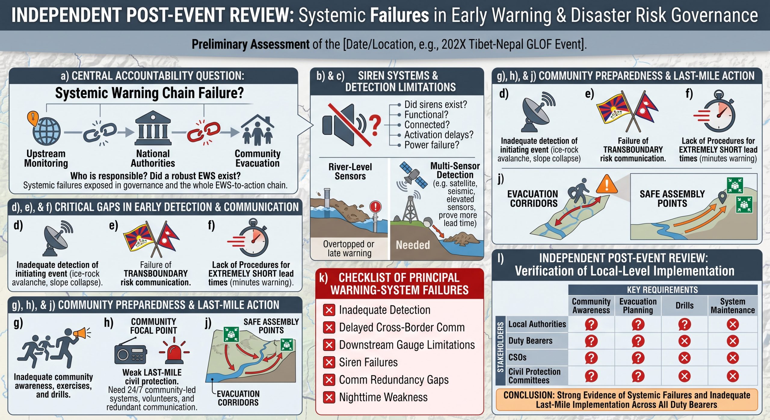
a) Central Accountability Question: Who Was Responsible for the total failure to manage this catastrophe?
The central question extends beyond why a siren was not activated. The deeper issue is whether the disaster exposed systemic failures in disaster risk governance and the entire early warning-to-action chain. Did an operational siren alerting system exist, and was it connected to upstream monitoring, clear activation protocols and community evacuation procedures? If such a system existed, why were people not warned of the approaching danger? What measures had national authorities and international partners taken to establish, maintain and test a robust, people-centred early warning system capable of detecting an upstream event, assessing its likely downstream consequences, issuing warnings within seconds or minutes, reaching every exposed community and triggering immediate, safe evacuation? Were institutional responsibilities clearly assigned, and were communities prepared to act upon receiving a warning?
These concerns demand transparent, evidence-based answers about preparedness, operational capacity, coordination and accountability. We therefore call on Nepal’s authorities and the relevant national and international stakeholders to address the following critical questions: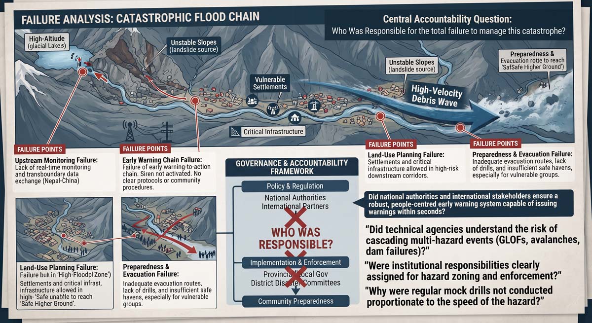
How and why were settlements, commercial facilities, hydropower installations and other critical infrastructure established, expanded or allowed to remain within high-risk downstream drainage corridors and lower floodplains exposed to potential GLOFs, avalanches, landslide-dam outbursts, debris flows and cascading reservoir failures? Which authorities were responsible for hazard zoning, land-use planning, development approval, construction permitting, enforcement, risk reduction and, where necessary, relocation?
Does Nepal’s disaster risk governance system adequately account for the interaction of the country’s geography, geology, steep topography, meteorological regime and transboundary river systems, which can generate exceptionally rapid and cascading multi-hazard events? Is the system sufficiently equipped, staffed, financed and coordinated to manage hazards that may leave only seconds or minutes for protective action in nearby communities?
MHEWC has previously raised concerns about potential gaps in institutional responsibility and technical understanding among duty bearers, civil society organizations, humanitarian actors, infrastructure operators and community institutions. Were these actors adequately aware that a GLOF, ice-rock avalanche, landslide-induced river blockage, flash flood or cascading hydropower dam failure could generate a catastrophic, high-velocity and tsunami-like flood or debris wave through a confined Himalayan valley?
Did technical agencies, engineers, planners, regulators, hydropower operators and emergency authorities understand and plan for the possibility that combined GLOF, avalanche, river-blockage and reservoir-failure processes could produce devastating downstream impacts within minutes? If the risk was understood, why were disaster risk management standards and preparedness arrangements not proportionate to the severity and speed of the hazard?
What operational arrangements existed between Nepal and China for real-time monitoring, transboundary data exchange, rapid event notification, impact forecasting and emergency communication? If such arrangements were absent, incomplete or not activated, what institutional, diplomatic, legal or technical barriers prevented their establishment or effective operation?
Did Nepal’s Department of Hydrology and Meteorology, the National Disaster Risk Reduction and Management Authority, provincial and local governments, District and Local Disaster Management Committees, security agencies, ward-level structures, civil society organizations, infrastructure operators and community institutions formally identify this river corridor as a priority multi-hazard hotspot? If it was identified, why were adequate risk-reduction measures not implemented? If it was not identified, why did the national and local risk-assessment systems fail to recognize the danger?
Were detailed multi-hazard risk assessments, flood and debris-flow modelling, flood-wave arrival-time estimates, exposure inventories, vulnerability assessments and land-use zoning undertaken for the affected corridor? If assessments existed, were their recommendations communicated, financed and implemented? If they did not exist, which institutions were responsible for ensuring that they were completed?
Why were protected, accessible and clearly marked evacuation routes, stairways, ramps, footpaths, bridges, vertical-evacuation structures and safe higher-ground areas apparently absent or inadequate? Were these facilities designed to allow children, older persons, persons with disabilities, tourists, workers and other at-risk groups to evacuate within the extremely limited warning time?
Were regular mock drills and evacuation exercises conducted using realistic, high-magnitude and short-lead-time scenarios? Did the exercises include nighttime emergencies, power and communication failures, blocked evacuation routes, tourists and temporary workers, and people requiring evacuation assistance? If not, why were preparedness activities not aligned with the actual scale and speed of the hazards?
Why was a basic siren or voice-warning system apparently not activated before the destructive surge reached exposed communities? Were sirens installed, functional, audible and connected to operational monitoring and decision-making systems? Why had an automated siren and voice-warning network, supported by redundant communication channels, backup power and local activation controls, not been installed, routinely tested and practised?
Were designated evacuation corridors and safe areas absent, inaccessible, poorly maintained, inadequately marked or unknown to residents? Which institutions were responsible for providing and maintaining them, and why were these life-saving requirements not addressed before the disaster?
Note: MHEWC respectfully requests an opportunity to engage with the Government of Nepal and the relevant national, provincial and local authorities. MHEWC stands ready to provide technical support for developing a comprehensive, risk-informed disaster risk management plan and designing and implementing an end-to-end, people-centred multi-hazard early warning system.
b) Absence or non-activation of automated sirens
It appears that exposed riverside settlements did not receive automated siren and loudspeaker warnings. The investigation should determine:
- whether siren systems existed in the affected settlements;
- whether the sirens were functional at the time of the event;
- whether they were connected to upstream monitoring stations or emergency operations centres;
- whether any activation signal was issued;
- whether activation required administrative approval that caused delay;
- whether electricity or communication failure prevented activation;
- whether local authorities had manual activation controls; and
- whether communities could hear, recognize and understand the warning signal.
c) The lack of elevated Multi-Sensor Detection and Automated Siren Warning for Extreme GLOFs and Debris Flows:
Existing river-level sensors should not be relied upon as the sole detection mechanism for an extreme GLOF, avalanche-induced outburst flood or high-velocity debris flow. A gauge installed within or beside the river channel may detect the surge only after it has already entered the downstream reach. It may also be overtopped, buried, damaged or completely destroyed by mud, boulders and other debris. River-level sensors remain valuable for confirming and tracking flood-wave propagation, but they may not provide sufficient warning lead time for nearby settlements.
Protected debris-flow and flash-flood detection stations should therefore be installed on stable, elevated ground outside identified avalanche, debris-flow and inundation zones. Each station should integrate non-contact radar-based water-level and velocity sensors, thermal infrared and optical cameras, seismic sensors, geophones, infrasound instruments and other appropriate detectors. The system should automatically detect the approaching flood front, estimate its height, velocity and direction of movement, and transmit the observations through redundant UHF/VHF radio, satellite, cellular and internet communication pathways to an AI-driven monitoring and warning platform.
When approved emergency thresholds are exceeded and the event is confirmed by multiple independent sensors, the platform should automatically activate a Common Alerting Protocol-compliant siren-loop network. High-output sirens and voice-capable loudspeakers should be sufficiently audible to awaken sleeping residents and immediately instruct exposed communities to evacuate through designated routes and move to identified safe areas or higher ground. The warning should be repeated at approved intervals until the danger has passed or authorized officials issue further instructions.
d) Inadequate detection of the initiating event
The existing observation system may not have detected the initial ice-rock avalanche, slope collapse, temporary river blockage, impoundment or sudden release early enough to support warning.
Conventional rainfall forecasts and downstream river gauges cannot independently provide adequate warning for an avalanche-induced flash flood. By the time a downstream gauge detects the surge, the flood may already be approaching nearby settlements.
The apparent monitoring gaps include: inadequate real-time surveillance of glacier and unstable-slope source areas; limited seismic, infrasound and ground-radar detection of avalanches and rockfalls; insufficient monitoring of temporary river blockages and impounded water; inadequate upstream and downstream water-level sensor networks; limited autonomous drone surveillance during elevated-risk periods; insufficient integration of satellite, ground-sensor, drone and community observations; and absence of an automated threshold-based detection and alerting platform.
e) Failure of transboundary risk communication
Because the event originated in Tibet and travelled into Nepal, an effective warning depended on immediate communication between Chinese and Nepalese authorities.
The investigation should establish: when the event was first detected on the Chinese side; whether information was transmitted to Nepal; which Nepalese institution received the information; how long transmission, verification and authorization took; whether common alert thresholds and message formats existed; whether 24/7 emergency contact points were operational; and whether warnings could be transmitted directly to downstream emergency operations centres and communities.
A permanent China-Nepal transboundary warning network should integrate satellite communication, UHF/VHF radio, mobile networks, internet services and locally controlled warning stations. Common Alerting Protocol-compliant messages should enable the same verified warning to be disseminated simultaneously across institutional and national boundaries.
BeiDou, other satellite-navigation services and Japanese or international Earth-observation systems may support positioning, communication and remote sensing. However, satellites do not automatically warn communities. They must be integrated with hazard-detection algorithms, decision protocols, emergency communication systems, sirens and community evacuation procedures.
f) Lack of procedures for disasters with extremely short lead times
Standard operating procedures appear to be inadequate for hazards that provide only a few minutes of warning. Separate procedures are required for GLOFs, avalanche-induced river blockages, flash floods, earthquakes, rockfalls, debris flows and cascading multi-hazard events.
The procedures should define: automatic and semi-automatic alert thresholds; authority for issuing pre-authorized emergency warnings; actions for lead-time windows of less than 5 minutes, 5-15 minutes and 15-30 minutes; immediate evacuation messages; local activation arrangements when national systems fail; communication and power failover procedures; responsibilities of every participating institution; and procedures for confirming that communities received and acted upon the warning.
For a five-minute event, warning messages must be extremely simple: “Extreme flood approaching. Move immediately to designated higher ground. Do not wait. Do not approach the river.”
g) Inadequate community preparedness, mock exercises and evacuation planning
Exposed communities should have received regular awareness programmes, simulation exercises and evacuation drills based on credible worst-case scenarios.
The absence or inadequacy of such preparedness raises several questions:
- Were communities informed that a sudden glacier, avalanche or landslide-induced flood could occur?
- Were community, household and individual level risk perceptions on fastest onset impending multi-hazard and being improved?
- Did residents understand the siren tones and voice instructions?
- Were evacuation routes clearly marked?
- Were safe areas and assembly points identified?
- Were nighttime drills conducted?
- Were children, older people, persons with disabilities, tourists and migrant workers included?
- Were hotels, markets, border facilities, hydropower projects and construction sites covered?
- Were community volunteers trained and available at all times?
When warning lead time is extremely short, prior knowledge and repeated practice determine whether people act immediately or lose critical minutes seeking confirmation.
h) Weak last-mile civil-protection arrangements
A community-led emergency protection system should remain operational 24/7 in every high-risk river corridor. It should include local warning focal points, trained volunteers, manual siren controls, portable radios, satellite communication, backup power, pre-recorded voice messages and arrangements for assisting vulnerable people.
In Nepal, responsibility cannot be assigned to a single organization. The duty-bearing system includes the Department of Hydrology and Meteorology, the National Disaster Risk Reduction and Management Authority, provincial and local governments, District and Local Disaster Management Committees, security agencies, ward-level structures, civil society organizations, infrastructure operators and community institutions.
The Nepal Centre for Disaster Management is not a substitute for these statutory authorities. Technically demanding and extremely rapid hazards require a professionally managed, multi-agency and real-time risk-governance system extending from the source area to every last-mile community.
i) Governance and accountability gaps
Local governments and disaster-management committees should be accountable for community risk awareness, evacuation planning, drills, warning-system maintenance and last-mile preparedness. However, they also require adequate technical support, legal authority, trained personnel and sustainable funding.
The apparent weaknesses may reflect: fragmented institutional mandates; unclear responsibility for issuing warnings; centralized and slow authorization procedures; inadequate local technical capacity; insufficient budgets for operation and maintenance; lack of binding transboundary data-sharing agreements; limited integration of scientific agencies and local authorities; dependence on short-term projects; inadequate enforcement of risk-sensitive land-use planning; weak public accountability for system readiness; and failure to adopt available automated monitoring and communication technologies.
j) Evacuation corridors and protective infrastructure
Every densely populated high-risk settlement should have rapid evacuation routes leading away from the river and toward geotechnically assessed higher ground. Depending on the terrain, these should include: marked evacuation corridors; reinforced stairs and uphill footpaths; handrails and non-slip surfaces; emergency lighting; directional signs; alternative routes where the primary route may be blocked; access arrangements for persons with disabilities; assembly points and refuge areas; and routine inspection and maintenance.
Where natural higher ground cannot be reached within the available lead time, engineered vertical-evacuation refuges or elevated concrete platforms should be considered. These structures should not be described as completely “landslide-proof.” They must be designed by qualified geotechnical, hydraulic and structural engineers for defined flood, debris-impact, seismic, erosion and slope-instability loads. They must also be located outside identified landslide, rockfall and major debris-flow impact zones wherever possible.
k) Principal warning-system failures requiring verification
The apparent failure points include: inadequate detection of the initiating ice-rock avalanche or slope collapse; limited real-time monitoring of the transboundary source area; delayed or absent cross-border hazard communication; insufficient lead time from downstream river gauges; absence or non-activation of automated sirens; gaps in loudspeaker coverage; limited multilingual and actionable voice messaging; dependence on electricity, mobile networks or internet connectivity; inadequate satellite, UHF and VHF communication redundancy; failure to disseminate warnings simultaneously through all available channels; inadequate nighttime warning and evacuation arrangements; insufficiently marked evacuation routes and safe areas; limited community drills and preparedness training; unclear institutional responsibility and warning authority; and weak systems for confirming whether warnings were received, understood and acted upon.
- The incidence site detected upstream but was not transmitted promptly across the Nepal-China border;
- responsible institutions received the information but did not interpret, escalate or convert it into a public warning;
- warning issuance was delayed by verification, authorization or administrative procedures;
- a warning was issued but was delayed, interrupted or lost during transmission;
- sirens, voice-capable loudspeakers, communication networks or backup power systems were absent, non-functional or unable to cover all exposed settlements;
- communities received no official warning and first became aware of the danger only after hearing the roar of the approaching flood, impacts upstream or the cries of people fleeing, by which time meaningful evacuation time had almost disappeared;
- messages were received only seconds or minutes before impact but did not adequately communicate the magnitude, velocity, expected arrival time or life-threatening severity of the approaching surge;
- warning messages failed to provide clear instructions to evacuate immediately to identified safe areas or higher ground;
- residents in communities close to the river recognized that a major surge was approaching but lacked safe, direct and accessible evacuation routes;
- children, older persons, persons with disabilities, tourists and other at-risk groups were unable to reach higher ground within the available time;
- settlements lacked closely spaced vertical-evacuation infrastructure, including protected stairways, ramps, footpaths, bridges and evacuation corridors connecting riverside areas with higher ground;
- evacuation routes were blocked, damaged, poorly marked, unlit or unsuitable for rapid nighttime movement;
- communities had not received adequate preparedness training, evacuation drills or guidance on responding immediately to natural warning signs; or
- the event developed with such exceptional speed, magnitude and debris concentration that the existing monitoring and warning arrangements could not provide meaningful lead time.
The review should examine sensor and telemetry records, satellite and seismic data, emergency-operation logs, transboundary communications, warning authorization records, siren activation logs, mobile and broadcast transmission records, equipment-maintenance histories, evacuation-route conditions and community testimony. It should reconstruct the timeline from the initial slope failure to the arrival of the destructive surge in each settlement and determine how much warning time was technically available, institutionally used and practically available for evacuation.
The objective should not be limited to assigning responsibility. It should identify failures and gaps across every component of the end-to-end warning system, including risk knowledge, hazard detection, forecasting, decision-making, transboundary communication, warning dissemination, community preparedness and access to safe higher ground.
l) An independent post-event and situation updates review to determine whether the following issues are not addressed at the last-mile by the local authority, duty bearer, CSOs, and civil protection committees
The event should not yet be classified conclusively as a complete early warning system failure. An independent review must determine whether:
- the hazard was not detected by the locally installed system; when the community understood that a big blow was coming, it was already too late to evacuate and rescue them;
- sirens, voice-capable loudspeakers, communication networks or backup power systems were absent, non-functional or unable to cover all exposed settlements;
- at what level communities received alerts from existing siren system, official warning is not clear; apparently they first became aware of the danger only after hearing the roar of the approaching flood, impacts upstream or the cries of people fleeing, by which time meaningful evacuation time had almost disappeared;
- messages were received only seconds or minutes before impact but did not adequately communicate the magnitude, velocity, expected arrival time or life-threatening severity of the approaching surge;
- warning messages failed to provide clear instructions to evacuate immediately to identified safe areas or higher ground;
- residents in communities close to the river recognized that a major surge was approaching but lacked safe, direct and accessible evacuation routes;
- children, older persons, persons with disabilities, tourists and other at-risk groups were unable to reach higher ground within the available time;
- settlements lacked closely spaced vertical-evacuation infrastructure, including protected stairways, ramps, footpaths, bridges and evacuation corridors connecting riverside areas with higher ground;
- evacuation routes were blocked, damaged, poorly marked, unlit or unsuitable for rapid nighttime movement;
- communities had not received adequate preparedness training, evacuation drills or guidance on responding immediately to natural warning signs; or
- the event developed with such exceptional speed, magnitude and debris concentration that the existing monitoring and warning arrangements could not provide meaningful lead time.
- the information was not transmitted across the border;
- responsible institutions received the information but did not issue a warning;
- a warning was issued but failed during transmission;
- sirens or communication systems were non-functional or too inadequate to warn that this mega and fastest-onset event is coming in minutes;
- warnings reached only when the big sound of runoff and people’s screaming reached communities’ neighborhoods;
- some form of messages were received minutes/and seconds ago, but the magnitude of runoff was not understood;
- even those in close-proximity communities understood the big blow of river level runoff is coming but lacked accessible evacuation routes to quickly move to higher ground
- there was a lack of concrete staircase/corridor every few yards to move quickly to higher ground
- the event developed too rapidly for the existing system to provide meaningful lead time.
The review should reconstruct the event minute by minute, from slope failure and river disturbance to institutional detection, decision-making, warning dissemination, community receipt, evacuation and impact.
Rationale for a Drone-Centred, Multi-Sensor GLOF Monitoring and Warning System for tracking this sort of event
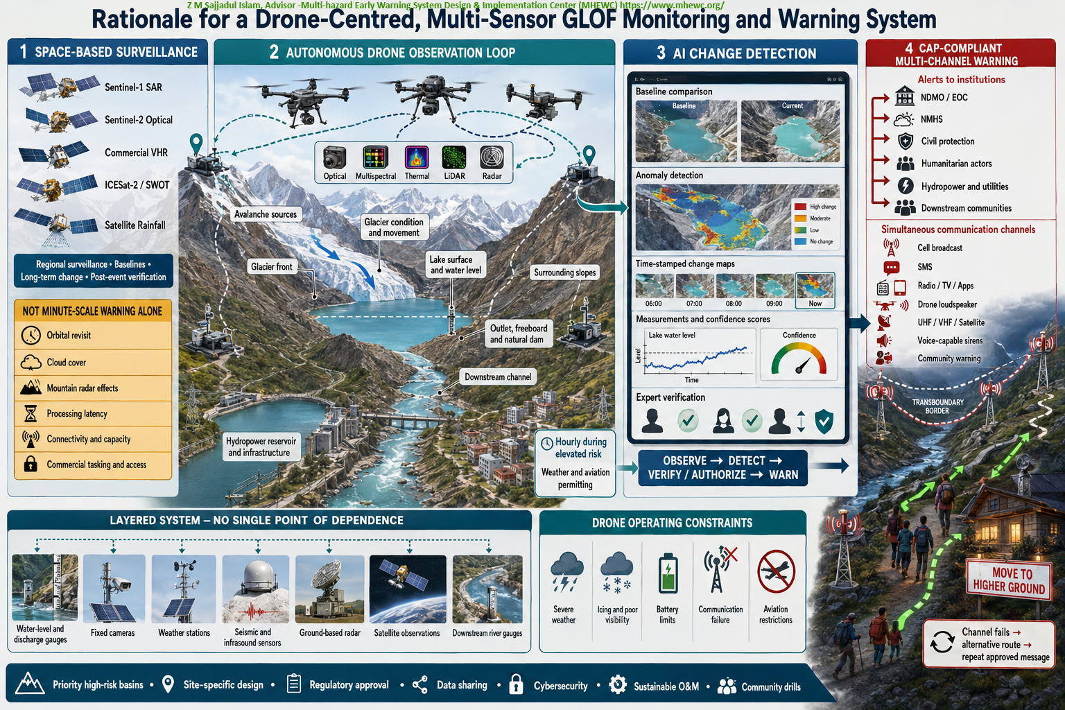
An operational GLOF-monitoring system should not rely predominantly on expensive Doppler weather radar, high-cost remote-sensing infrastructure or satellite observations alone. Sentinel-1 SAR and Sentinel-2 optical imagery should form the core space-based monitoring layer, supplemented by high-resolution commercial imagery, ICESat-2 or SWOT observations, satellite rainfall products and automated change-detection algorithms.
Although Sentinel data are generally free and openly accessible, their effective operational use still depends on internet connectivity, data-processing capacity, technical expertise and product-delivery time. Direct satellite tasking, dedicated downlink services, very-high-resolution imagery and low-latency processed products are often governed by proprietary protocols and commercial arrangements. Many least developed and developing countries have limited access to these services and may lack the infrastructure required to receive, process and interpret the data rapidly.
Satellite observations are also constrained by orbital revisit intervals, acquisition schedules, cloud cover affecting optical imagery, mountainous terrain effects on radar imagery, processing latency and the time required to transmit products to responsible institutions. ICESat-2 and SWOT provide valuable measurements, but their track coverage and revisit characteristics do not support continuous observation of every glacial lake. Consequently, satellite systems are indispensable for regional surveillance, baseline mapping, long-term change analysis and post-event verification, but they cannot independently provide reliable minute-scale detection and warning of a sudden lake breach or rapidly developing outburst.
Recent advances in lower-cost and easier-to-operate drones provide an important opportunity to close this observation gap. Purpose-designed drones equipped with optical, multispectral, thermal, LiDAR, radar and other suitable sensors can repeatedly monitor avalanche-source areas, glacier conditions, glacier movement, glacier fronts, lake surfaces, water levels, surrounding slopes, lake outlets, moraine or natural dams, downstream channels, hydropower reservoirs and exposed infrastructure. Subject to connectivity and operating conditions, observations can be streamed in real or near-real time to a web-based monitoring platform.
Artificial-intelligence algorithms should compare incoming drone observations with baseline data, previous flights and fixed-sensor measurements. The platform should automatically identify abnormal glacier movement, new fractures, calving, avalanche deposits, rapid lake-level changes, outlet obstruction, declining freeboard, dam deformation, seepage, erosion, overtopping, downstream blockage and other indicators of possible outburst development. It should then generate time-stamped change maps, quantitative measurements, confidence scores and alerts for verification and operational decision-making.
A purpose-driven drone-observation loop should be established across each priority glacier-lake-river system. Multiple drones and automated docking stations should provide overlapping coverage and repeat standardized, georeferenced surveillance routes. During elevated-risk periods, missions may be conducted hourly or more frequently, subject to acceptable weather, visibility, icing, battery, communications and aviation-safety conditions.
The drone network should be integrated with a Common Alerting Protocol-compliant warning platform. When approved technical thresholds and verification or authorization requirements are satisfied, the system should generate and disseminate CAP-compliant alerts simultaneously to: national disaster management organizations; civil-protection and local disaster management committees; national meteorological and hydrological services; humanitarian organizations; sectoral ministries and departments; security and emergency-response agencies; vulnerable households and downstream communities; commercial establishments; hydropower and other critical infrastructure operators; and essential utility-service providers.
Alerts should be delivered through drone-mounted loudspeakers, cell broadcast, SMS, radio, television, mobile applications, security communication networks and community-warning systems. The drones should also connect via UHF, VHF, and satellite communications to a transboundary network of high-output, voice-capable surface sirens. If one communication pathway fails, the platform should automatically switch to an available alternative and repeat the approved message at specified intervals.
Siren coverage should be determined through exposure mapping, acoustic modeling and field testing. Warning tones and multilingual voice messages should be sufficiently distinctive and audible to alert people during nighttime emergencies, including those who may be asleep. Messages should clearly communicate the hazard, estimated flood-arrival time and associated uncertainty, evacuation routes, safe areas and the immediate requirement to move to higher ground.
Drones should nevertheless remain part of a layered system rather than become a single point of dependence. Severe winds, precipitation, icing, poor visibility, battery limitations, communication failure and aviation restrictions may interrupt drone operations. The drone network should therefore be integrated with water-level and discharge gauges, fixed cameras, weather stations, seismic and infrasound sensors, ground-based radar, satellite observations and downstream river gauges.
The component technologies required for this integrated monitoring and warning system are already available. They should be adapted, tested and progressively installed in priority high-risk basins through site-specific design, regulatory approval, transboundary data-sharing arrangements, cybersecurity controls, institutional operating procedures, sustainable maintenance financing and regular community evacuation drills.
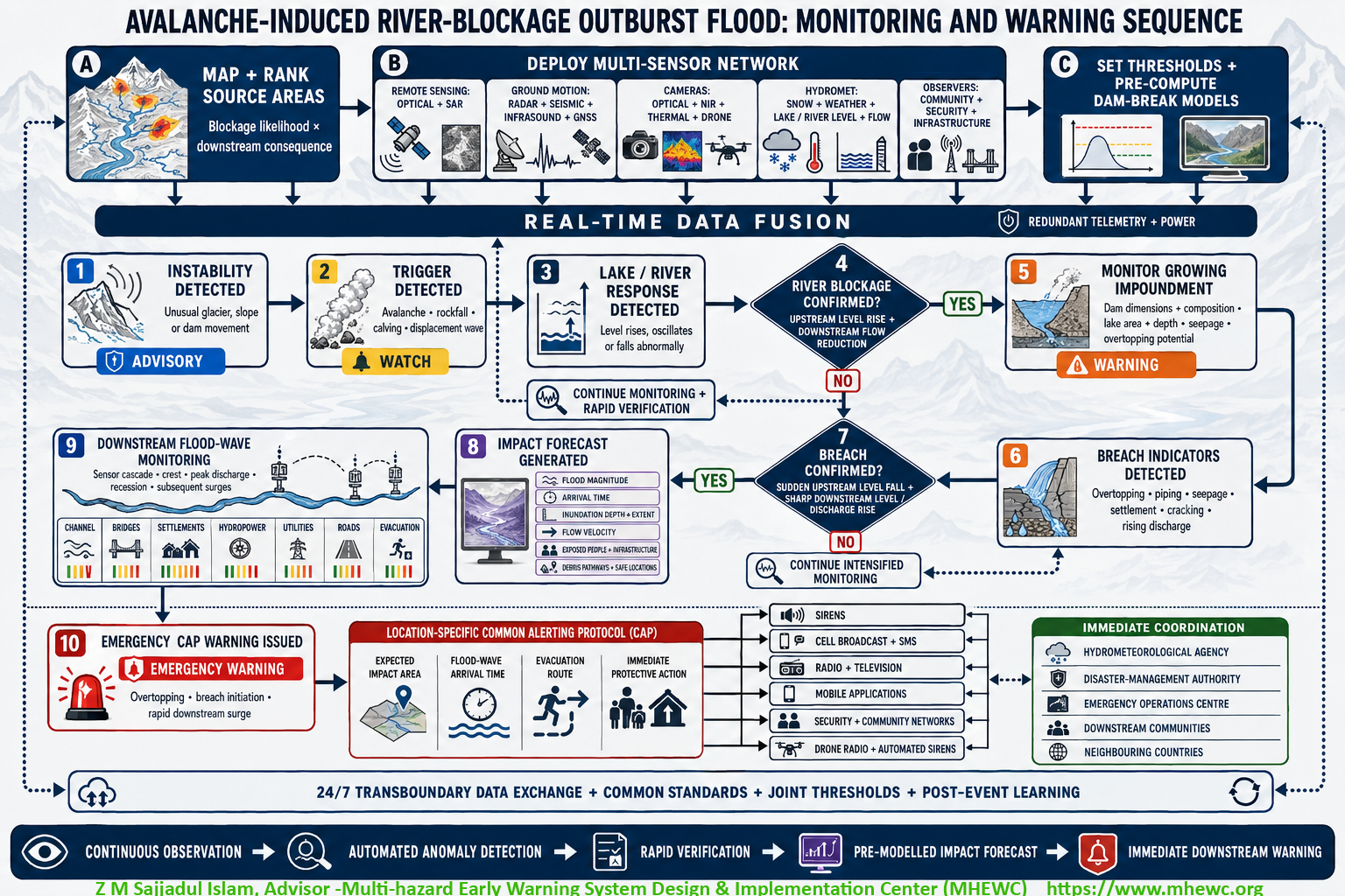
Proposition for a robust operational platform that should follow a seven-stage detection-to-warning sequence:
instability is detected in a glacier, rock-ice slope or natural dam; an avalanche, rockfall, calving event or displacement wave is recorded; an abnormal response is detected in the river or impounded water; overtopping, erosion, deformation, seepage or rapidly increasing discharge is identified; breach or sudden release is confirmed through simultaneous upstream and downstream changes; flood magnitude, arrival time, inundation depth, velocity and exposed elements are calculated; and an emergency warning is issued to responsible institutions and downstream communities.
A cascade of downstream river stations should track the flood-wave crest, peak discharge, flow velocity, debris concentration, water-level recession and possible secondary surges. Dam-break and hydraulic models must be prepared in advance for multiple blockage, impoundment and breach scenarios. These models should identify expected flood-wave arrival times, inundation depths, flow velocities, debris-flow pathways, exposed populations and infrastructure, evacuation routes and safe locations. Real-time observations can then update the pre-modeled scenarios and generate location-specific impact forecasts.
1.0 Required monitoring avalanche-source areas
Potential avalanche-source zones, hanging glaciers, unstable rock-ice slopes, and narrow river gorges should first be mapped and ranked according to their likelihood of blocking a river and the downstream potential consequences. Priority locations should be monitored using: optical and Synthetic Aperture Radar satellite imagery; Real-time Glacial-lake breach observation using infrared cameras, satellite-based terrain-displacement and change detection; ground-based radar, where technically feasible; seismic sensors, geophones and infrasound instruments; GNSS instruments, tiltmeters and crack-monitoring sensors; automatic cameras and thermal-imaging systems; snow-depth, snow-temperature and snow-water-equivalent sensors; automatic weather stations; and periodic drone surveys under safe operating conditions.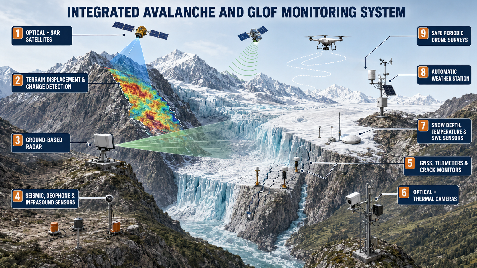
Synthetic Aperture Radar is particularly valuable because it can observe terrain through cloud cover and during darkness. However, satellite observations alone may not provide sufficient temporal resolution for rapidly developing events. They must be complemented by continuously operating ground sensors.
1.1 Hourly Autonomous Drone Surveillance of Glacial-Lake and Glacier Conditions and connecting drainage channel
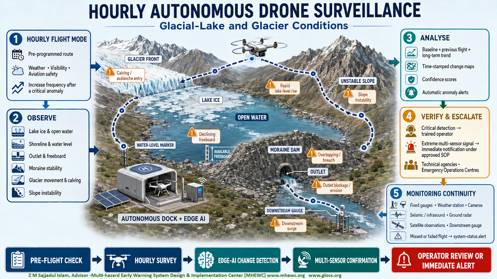
An autonomous drone-based monitoring system should be installed and maintained at priority glacial lakes to provide repeatable spatial observations of lake-ice conditions, water-level changes, glacier behaviour, outlet stability and other indicators of potential GLOF development. During elevated-risk periods, the system should conduct pre-programmed surveillance flights at hourly intervals, subject to acceptable weather, visibility and aviation-safety conditions. Where operationally feasible, flight frequency may be increased following rapid lake-level rise, major calving, avalanche entry, outlet obstruction, accelerated erosion or another critical anomaly.
Each mission should follow a standardized, georeferenced route to map lake ice and open water; measure changes in the shoreline and water level against surveyed reference points; assess the outlet, moraine dam and available freeboard; and monitor glacier-front movement, cracking, calving and instability on surrounding slopes. Artificial-intelligence algorithms should compare every survey with baseline conditions, the preceding flight and longer-term observations. The system should automatically produce time-stamped change maps, quantitative measurements, confidence scores and alerts identifying abnormal or rapidly developing conditions.
Hourly drone surveillance should complement not replace continuous monitoring by fixed water-level gauges, automatic weather stations, cameras, seismic and infrasound sensors, ground-based radar and other instruments. Fixed sensors should provide continuous or high-frequency measurements, while drone observations provide the spatial evidence required to identify the location, extent and probable cause of detected changes. When adverse weather, poor visibility, icing, equipment failure or aviation restrictions prevent drone operations, ground instruments, radar and satellite observations should maintain monitoring continuity until safe flight operations can resume.
1.1 a) Monitoring objectives
Each flight should systematically assess: the extent and distribution of lake ice and open water; development, enlargement and movement of cracks within the lake ice; formation of melt ponds and drainage channels; changes in the lake shoreline and surface area; lake water level relative to surveyed reference markers; available freeboard between the water surface and the moraine or natural-dam crest; condition of the lake outlet, spillway and drainage channels; seepage, erosion, slumping or deformation of the moraine dam; glacier-front position and changes in ice overhang; glacier-surface cracks, crevasses and zones of instability; glacier movement and acceleration; calving, icefall, avalanche and rockfall activity; displacement waves or unusual surface-water disturbances; and debris accumulation or obstruction at the outlet.
| Monitoring target | Drone-derived information | Operational significance |
|---|---|---|
| Lake ice | Ice extent, open-water areas, cracks, movement and breakup | Identifies weakening ice, changing lake conditions and possible displacement-wave hazards |
| Water level | Shoreline position and water-surface elevation relative to fixed benchmarks | Detects rapid filling, abnormal rise and declining freeboard |
| Lake outlet | Channel width, erosion, sediment accumulation and obstruction | Indicates reduced drainage capacity or developing overtopping risk |
| Moraine or natural dam | Cracks, settlement, slumping, seepage zones and surface erosion | Identifies structural deterioration and possible failure pathways |
| Glacier front | Terminus position, overhanging ice, fractures and calving | Detects potential sources of sudden ice entry and displacement waves |
| Surrounding slopes | New cracks, rockfall, avalanche deposits and slope movement | Identifies cascading hazards capable of entering or blocking the lake |
| Lake surface | Waves, turbulence, floating debris and rapid ice movement | Provides evidence of calving, avalanche entry or abnormal outflow |
| Downstream channel | Sudden flow change, erosion, debris movement or inundation | Supports confirmation and tracking of an emerging GLOF |
Standardized flight operation
Every mission should follow the same flight corridor, altitude, camera orientation, observation points and image-overlap requirements so that successive datasets can be compared reliably. The monitoring route should cover the glacier front, the complete lake perimeter, moraine dam, outlet, adjacent unstable slopes and the initial downstream channel.
The system should include: an automated weather-resistant docking and charging station; remote mission planning and flight-control software; Real-Time Kinematic or Post-Processed Kinematic positioning where feasible; surveyed ground-reference targets and permanent water-level markers; optical and thermal cameras, supplemented by multispectral or LiDAR sensors where technically justified; onboard or edge-computing equipment for rapid image processing; automated battery, propulsion, navigation and communication checks; geofencing, obstacle avoidance, lost-link procedures and safe return-to-home functions; redundant power supplied through solar, battery and available grid systems; cellular, radio, satellite or other redundant telemetry connections; and secure local storage when real-time data transmission is interrupted.
Before each flight, the system should automatically assess wind speed, precipitation, visibility, temperature, icing potential, battery condition, navigation accuracy, communications and airspace restrictions. A mission should proceed only when predefined safety requirements are satisfied. If a flight is cancelled, delayed or incomplete, the system should notify the operator and record the reason.
1.1 b) Water-level measurement
Drone imagery should be used to map the waterline and estimate changes in lake area and water-surface elevation against stable, surveyed reference points. Because imagery alone may not provide sufficiently accurate water-level measurements particularly where the water surface is reflective, ice-covered or poorly textured—drone estimates should be validated using radar, pressure-transducer or other fixed lake-level gauges.
The system should automatically compare: the current water level with the previous flight; the current level with seasonal and historical baselines; observed rise rates with agreed technical thresholds; water level with the moraine-dam crest and available freeboard; and lake inflow with observed outlet discharge.
A rapid lake-level rise combined with reduced outlet flow, declining freeboard, outlet blockage or dam deformation should receive a higher risk classification than a water-level change detected in isolation.
1.1 c) Glacier tracking
Successive georeferenced images should be used to monitor the glacier front, unstable ice masses, crevasses, calving zones and changes in glacier-surface movement. Artificial-intelligence-assisted feature tracking can compare the location of recognizable surface features across multiple flights and estimate displacement.
Hourly imagery is particularly valuable for detecting sudden events such as calving, ice collapse, avalanche entry or rapid crack enlargement. However, gradual glacier velocity may be too small to measure accurately over a single hour. Movement estimates should therefore also be calculated over daily, weekly and seasonal observation windows to distinguish sustained acceleration from image-registration error or temporary surface changes.
1.1 d) Automated image analysis
Images should be processed automatically at the docking station or monitoring site whenever sufficient edge-computing capacity is available. Computer-vision algorithms should: delineate water, snow, ice, rock, vegetation and debris; calculate lake area and ice-cover percentage; identify the lake shoreline and estimate water-level change; measure available dam freeboard; track the glacier front and unstable ice masses; detect new cracks, calving, avalanches and rockfalls; identify outlet enlargement, blockage, seepage and erosion; detect overtopping, displacement waves or rapidly increasing outflow; and compare observations with predefined warning thresholds.
Every detection should include its location, observation time, magnitude of change, confidence score, supporting imagery and comparison with the previous flight and longer-term baseline. Low-bandwidth systems should transmit alerts, thumbnails and essential measurements first, followed by full-resolution imagery when communication capacity permits.
1.1 e) Verification and warning escalation
The analytical platform should combine drone observations with water-level gauges, cameras, seismic or infrasound sensors, weather observations, satellite imagery and hydrological forecasts. A critical detection should normally be reviewed by a trained operator before a public warning is issued.
The system should automatically escalate the situation when it detects: rapid lake-level rise; accelerated decline in freeboard; major glacier calving or avalanche entry; expanding cracks or movement of an unstable ice mass; outlet blockage or rapidly increasing erosion; overtopping of the moraine dam; sudden lake-level drawdown; breach initiation; or a rapid downstream surge.
An extreme signal confirmed by multiple independent sensors such as sudden lake drawdown, observed breach formation and a downstream flow surge should trigger immediate automated notification to designated technical agencies and Emergency Operations Centres under an approved standard operating procedure. Public-warning authority and protective actions should remain with the legally designated government institutions.
1.1 f) Monitoring continuity and operational safeguards
Hourly drone missions may be interrupted by strong winds, snowfall, fog, darkness, icing, low temperature, communication failure, poor satellite navigation or aviation restrictions. Monitoring continuity should therefore be maintained through fixed lake-level sensors, time-lapse and thermal cameras, ground-based radar where available, satellite observations and downstream river gauges.
A missed or failed flight should itself generate a system-status alert. The operating agency should maintain spare batteries, replacement components and, at the highest-risk lakes, a backup drone or second docking station. Routine maintenance, sensor calibration, test flights, software validation and operator training should be completed according to an approved schedule.
All autonomous and beyond-visual-line-of-sight operations should comply with national aviation requirements and approved procedures for airspace coordination, geofencing, emergency landing, environmental protection and data security. The hourly-flight protocol should be tested through seasonal readiness exercises and adjusted using actual mission performance, false-alarm rates, missed detections and post-event reviews.
1.2 Real-Time Glacial-Lake Breach Observation Using Infrared Cameras
A real-time camera system combining thermal infrared, near-infrared, and conventional optical imaging can continuously monitor a glacial lake, its natural dam, outlet channel, surrounding glacier, and unstable mountain slopes. The system can support early detection of lake-level changes, glacier or rock-ice avalanches, displacement waves, overtopping and breach initiation.
1.2 a) What infrared cameras can detect
A properly positioned infrared camera can help identify: changes in the lake shoreline and surface area; progressive or sudden changes in water level; temperature contrasts among water, ice, snow and exposed rock; movement or calving at the glacier front; ice or rock avalanches entering the lake; displacement waves generated by mass movements; overtopping of an ice, moraine or landslide dam; visible seepage and changing moisture conditions on the downstream dam face; erosion and enlargement of the outlet channel; sudden discharge of sediment-laden water; and rapid emptying of the lake following breach initiation.
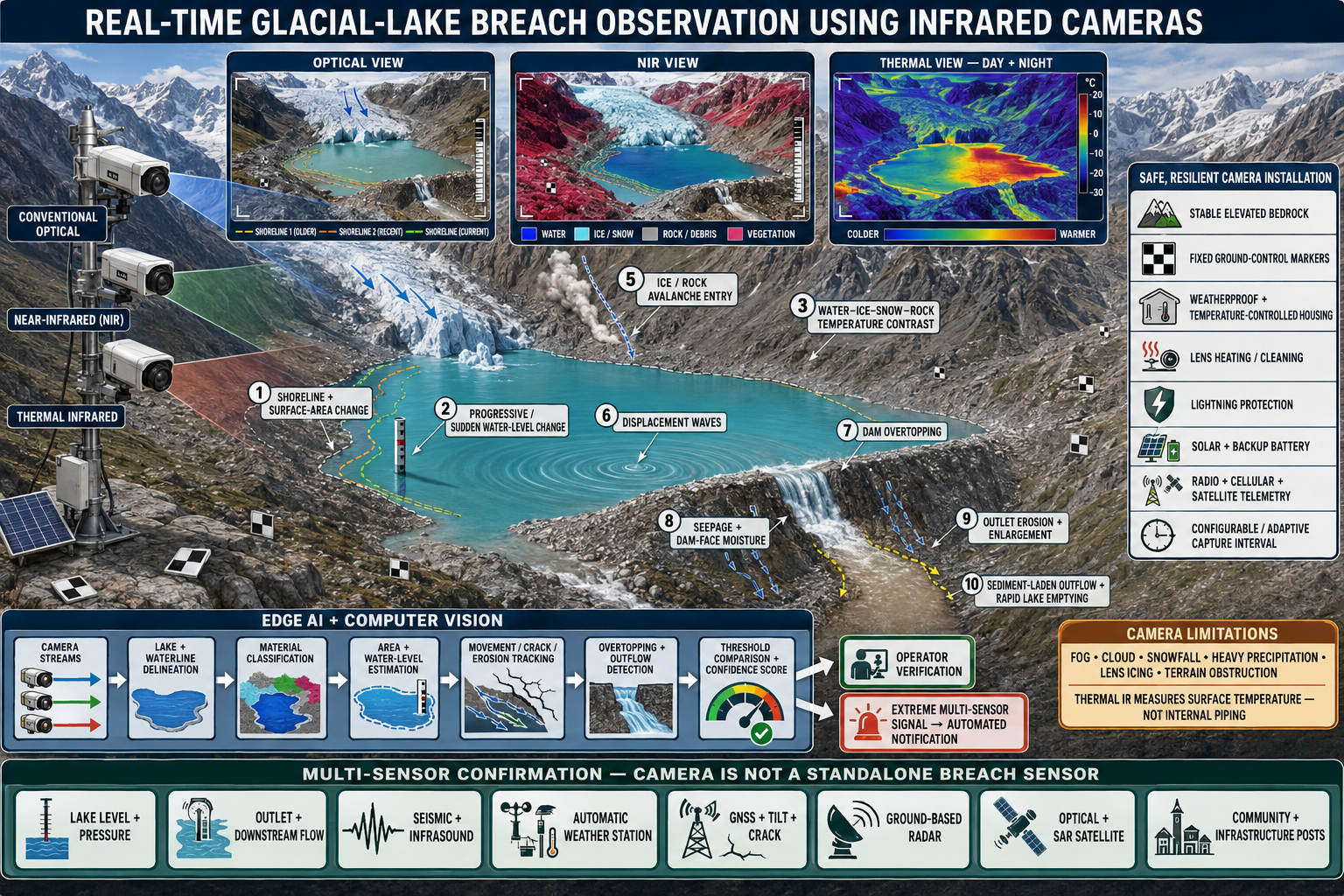
Near-infrared imagery can help distinguish water, ice, and rock through differences in their spectral reflectance. Thermal infrared cameras measure surface-temperature contrasts and can operate during both daylight and darkness, provided atmospheric and viewing conditions are suitable.
Camera-based photogrammetric monitoring has demonstrated that changes in a glacial lake’s waterline can be converted into estimates of water-level decline and volume loss when an accurate terrain or lake-basin model is available. Image-based pilot studies have measured lake-level changes at decimetre-scale precision. ISPRS photogrammetric GLOF-monitoring study .
1.2 b) Camera placement and operational requirements
The camera should be installed on stable, elevated bedrock outside the potential avalanche, wave-run-up, breach and flood-inundation zones. Its field of view should cover: the glacier front and possible avalanche-entry zones; the entire or critical portion of the lake; the moraine, ice or landslide dam; the lake outlet; the downstream dam face; and the initial flood channel.
Fixed ground-control markers should be established so that camera movement caused by wind, frost or ground instability can be automatically detected and corrected. The equipment should include weatherproof and temperature-controlled housing, lens heating or cleaning, lightning protection, solar power, backup batteries and redundant communication links through radio, cellular and satellite telemetry.
Images should be captured at short, configurable intervals. The frequency may automatically increase when abnormal lake behaviour, seismic activity, intense rainfall, rapid temperature change or slope movement is detected.
1.2 c) AI-assisted image analysis
Images should be transmitted or processed at the monitoring site through edge-computing equipment. Artificial intelligence and computer-vision algorithms can automatically: delineate the lake boundary and waterline; distinguish water, snow, ice, rock and vegetation; calculate changes in lake area and estimated water level; track glacier-front and slope movement; detect new cracks, erosion and outlet enlargement; recognize avalanches, calving events and displacement waves; identify overtopping or rapidly increasing outflow; and compare current conditions with predefined warning thresholds.
Every automatic detection should include a confidence score. Where communication permits, critical detections should be verified by a trained operator before public warning; however, an extreme, multi-sensor-confirmed breach signal should trigger immediate automated notification under an approved operating procedure.
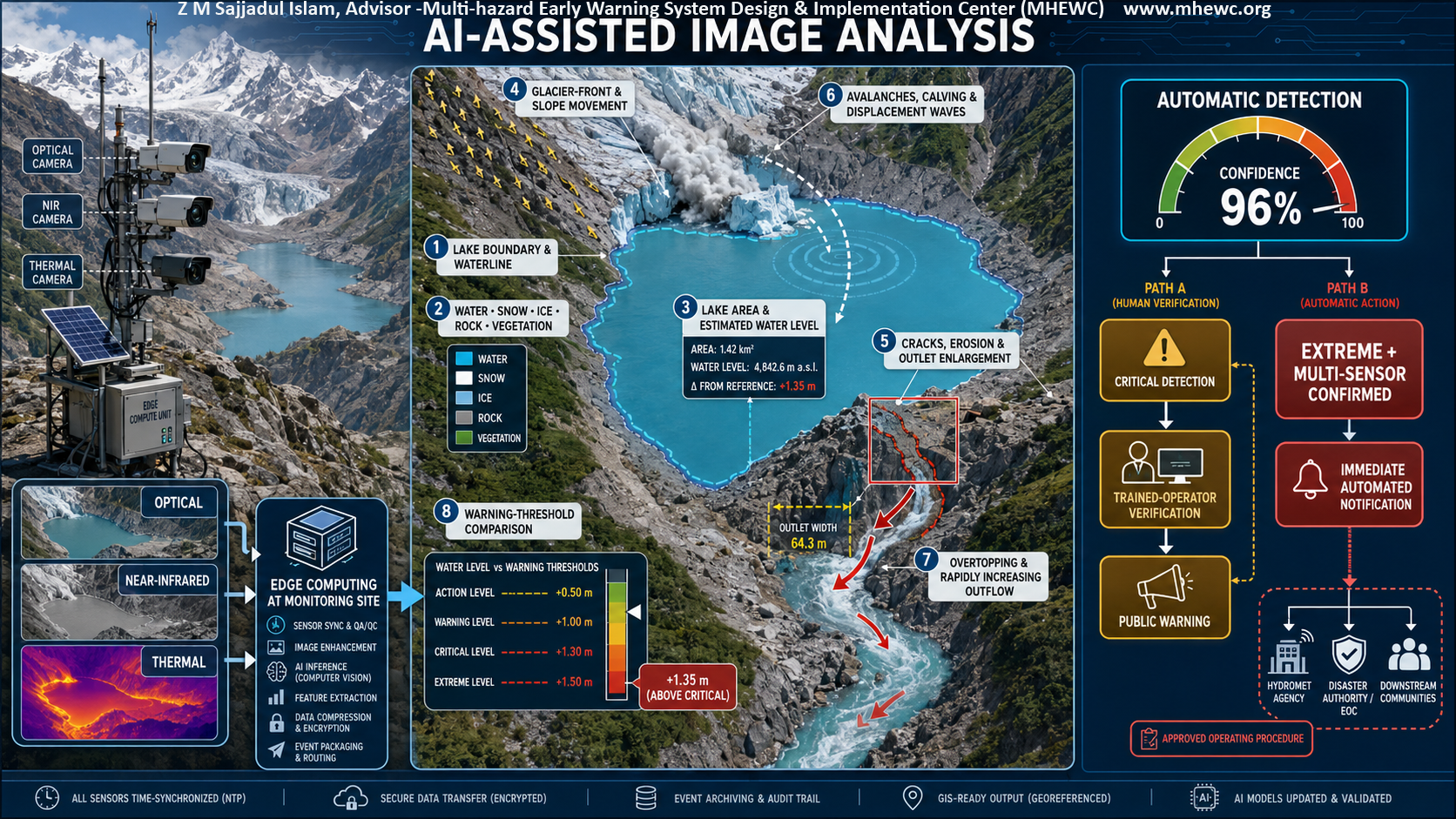
1.1 d) How to Conduct AI-Assisted Image Analysis
AI-assisted image analysis should follow a calibrated, multi-stage workflow that converts images from fixed optical, near-infrared and thermal cameras into verified observations and operational warnings. Processing should preferably occur on edge-computing equipment at the monitoring site so that essential detection and alert functions continue during internet or central-server failure.
1.2 d). 1 Acquire and calibrate the imagery
Cameras should capture georeferenced and accurately time-stamped images at predefined intervals. The system should automatically increase the capture frequency when abnormal movement, rapid lake-level change, intense rainfall, seismic activity or another trigger is detected.
Before operational analysis, each camera should be calibrated using surveyed ground-control points, known elevations, a digital elevation model and, where available, a lake-basin model. This enables image measurements to be converted from pixels into estimates of distance, lake area, water level, movement and discharge-related change.
1.2 d). 2 Check image quality
Every image should first pass an automated quality-control test. The system should identify: fog, cloud, snowfall, rain or poor illumination; lens icing, water droplets, dirt or physical obstruction; camera movement, vibration or misalignment; overexposed, underexposed or blurred images; missing pixels, transmission errors or incomplete files; and obstruction caused by new snow, vegetation or deposited material.
Each image should receive an image-quality score. Images below the approved quality threshold should not independently generate a public warning. Instead, the system should request another image, activate lens heating or cleaning, switch to an alternative camera, or rely more heavily on supporting sensors.
1.2 d). 3 Preprocess and align the images
The edge-processing unit should correct lens distortion, stabilize the image and align it with a fixed reference view. Optical, near-infrared and thermal images should be spatially registered so that the same feature can be compared across sensors.
Preprocessing may include illumination correction, noise reduction, thermal normalization, cloud and shadow masking, and adjustment for seasonal snow cover. Current images should then be compared with short-term, seasonal and historical baseline images.
1.2 d). 4 Perform computer-vision analysis
Separate but integrated AI models should undertake the following functions:
- Surface classification: Distinguish water, snow, glacier ice, debris-covered ice, rock, sediment and vegetation through semantic segmentation.
- Lake and waterline delineation: Map the lake boundary and identify changes in shoreline position, surface area and waterline elevation.
- Water-level estimation: Convert the detected waterline into an estimated elevation using camera geometry, ground-control points and a digital terrain or lake-basin model.
- Movement tracking: Apply feature tracking, image correlation or optical-flow analysis to estimate glacier-front, ice-cliff, moraine, natural-dam and unstable-slope movement.
- Crack and erosion detection: Identify new cracks, widening fractures, subsidence, seepage zones, outlet erosion, channel enlargement and changes in the downstream dam face.
- Rapid-event recognition: Detect and classify avalanches, rock–ice collapses, glacier-calving events, landslides, displacement waves and debris entering the lake or river.
- Outflow and breach detection: Identify overtopping, sudden water discoloration, sediment-rich discharge, rapid outlet enlargement, accelerating outflow and rapid lake drawdown.
- Threshold comparison: Compare observed rates and magnitudes of change with predefined site-specific thresholds for normal, advisory, watch, warning and emergency conditions.
Results should be confirmed across several consecutive images whenever the event permits. A single anomalous frame should not normally generate a public warning unless it captures an unmistakable extreme event and is corroborated by other sensors.
1.2 d). 5 Calculate a composite confidence score
Every detection should include a confidence score representing the reliability of the complete observation—not merely the probability produced by an individual AI model. The composite score should consider: model-detection probability; image quality and visibility; camera-calibration accuracy; magnitude and rate of detected change; persistence across consecutive images; agreement among optical, near-infrared and thermal imagery; consistency with historical and seasonal conditions; and corroboration from independent ground sensors.
The operational dashboard should display the detected feature, its location, estimated magnitude, direction and rate of change, confidence score, supporting evidence and applicable warning threshold. Confidence categories and escalation rules must be calibrated using site-specific observations and approved by the responsible authority; universal confidence cut-offs should not be applied without local testing.
1.2 d). 6 Fuse image results with other sensors
Camera detections should be automatically compared with data from: lake- and river-level sensors; pressure transducers and discharge gauges; seismic sensors, geophones and infrasound instruments; GNSS stations, tiltmeters and crack monitors; automatic weather and snow-monitoring stations; ground-based radar; satellite optical and Synthetic Aperture Radar observations; and community observers and infrastructure operators.
Sensor fusion should determine whether different instruments are detecting the same event within an appropriate spatial and temporal window. For example, an apparent avalanche in an image would receive greater confidence if accompanied by a seismic or infrasound signal, while suspected breaching would be strengthened by simultaneous lake-level decline, rising outlet discharge and increasing downstream river level.
1.1 d). 7 Apply operational decision rules
The system should follow an approved escalation procedure:
- Low-confidence or isolated anomaly: Record the observation, increase monitoring frequency and continue automated analysis.
- Moderate-confidence detection: Notify the monitoring operator and request additional images or supporting sensor data.
- High-confidence critical detection: Present the evidence to a trained operator for urgent verification and authorization of the appropriate warning.
- Extreme, multi-sensor-confirmed event: Immediately initiate automated emergency notification under an approved standard operating procedure, while simultaneously alerting duty officers and the Emergency Operations Centre.
Where communication permits, a trained operator should review critical detections before a public warning is issued. The operator should be able to inspect the original and annotated images, historical comparisons, sensor graphs, model confidence and predicted downstream consequences.
However, human verification should not delay life-saving action when the system detects an extreme breach or rapid downstream surge that meets all pre-approved emergency conditions. Automated activation should require several independent indicators, such as rapid lake drawdown, overtopping or outlet enlargement, a sharp increase in downstream water level, and corroborating seismic, infrasound or discharge signals.
1.2 d). 8 Generate and disseminate the warning
When an operational threshold is crossed, the system should send the verified event parameters to the forecasting and warning platform. Hydraulic or flood-routing models should estimate the expected impact area, flood-wave arrival time, inundation depth and affected settlements or infrastructure.
The platform should then generate a location-specific Common Alerting Protocol message containing: the hazard and warning level; the affected area; the expected flood-wave arrival time; the recommended evacuation route and safe area; the immediate protective action; the warning’s validity period; and the issuing and authorizing authority.
Emergency messages should be disseminated simultaneously through all approved channels, including sirens, cell broadcast, SMS, radio, television, mobile applications, security networks, drone-supported communication and community-warning systems.
1.1 d). 9 Maintain an auditable record
The system should retain the original images, processed images, model outputs, confidence scores, supporting sensor data, operator decisions, warning messages and dissemination records. These data are required for incident investigation, model improvement, system auditing and post-event review.
AI models should be periodically retrained and tested using locally representative imagery covering different seasons, lighting conditions, snow conditions and extreme events. Performance should be assessed using missed-event rates, false-alarm rates, precision, recall, detection time and warning lead time. Updated models should undergo controlled validation or “shadow-mode” testing before they are authorized to influence operational warnings.
AI-assisted image analysis should therefore function as part of a resilient multi-sensor decision-support system. It can accelerate detection and provide continuous surveillance, but public-warning decisions must remain governed by calibrated thresholds, independent sensor confirmation, trained human oversight and formally approved emergency operating procedures.
1.2 e) Required supporting sensors
An infrared camera should not be used as the only breach-detection instrument. Fog, cloud, snowfall, heavy precipitation, darkness for passive near-infrared systems, lens icing and terrain obstruction can reduce visibility. Thermal infrared imagery also observes surface temperatures and cannot independently detect internal erosion or piping within a dam.
The camera system should therefore be integrated with: radar or ultrasonic lake-level sensors; pressure transducers; outlet-flow and discharge gauges; downstream river-level and velocity sensors; geophones, seismic and infrasound sensors; automatic weather stations; GNSS, tiltmeters and crack-monitoring instruments; ground-based radar where feasible; satellite optical and Synthetic Aperture Radar observations; and community- and infrastructure-based observation posts.
A ground-based early-warning study for ice–rock collapses and river blockages demonstrated the value of combining water-level measurements, geophone signals, meteorological observations, and optical and thermal imagery rather than relying on one sensor. Natural Hazards and Earth System Sciences study
1.2 f) Automatic breach-detection sequence
The system should recognize the following sequence:
- Instability detected: Unusual glacier, slope or dam movement is identified.
- Trigger detected: An avalanche, rockfall, calving event or displacement wave is recorded.
- Lake response detected: The water level rises, oscillates or begins falling abnormally.
- Breach indicators detected: Overtopping, outlet erosion, dam deformation or rapidly increasing discharge is observed.
- Breach confirmed: A sudden lake-level fall occurs simultaneously with a sharp downstream water-level rise.
- Impact forecast generated: The platform calculates flood magnitude, travel time, inundation depth, flow velocity and exposed elements.
- Emergency warning issued: A location-specific CAP alert is transmitted to authorities, Emergency Operations Centres and downstream communities.
The monitoring platform should automatically display live imagery, sensor readings, detected anomalies, estimated breach probability and projected downstream impacts. A Himalayan glacial-lake monitoring framework should combine in-situ observations, remote sensing and hydrodynamic modeling to support dependable early warning. ICIMOD Himalayan monitoring-network framework
Infrared cameras can substantially improve continuous observation, particularly at night and where visible contrasts are weak. However, reliable glacial-lake breach warning depends on multi-sensor verification, resilient telemetry, pre-established thresholds, dam-break modelling and immediate downstream alert dissemination.

2.0 Detecting an avalanche and confirming river blockage
Seismic and infrasound sensors can detect the vibration and acoustic signals generated by a major ice–rock avalanche. Automated algorithms should distinguish these signals from earthquakes, blasting, vehicles and other sources of background noise.
When an avalanche signal is detected, the system should automatically examine: changes in upstream and downstream river levels; live camera images; satellite or ground-radar observations; seismic-event characteristics; weather and temperature conditions; and reports from nearby communities, security posts or infrastructure operators.
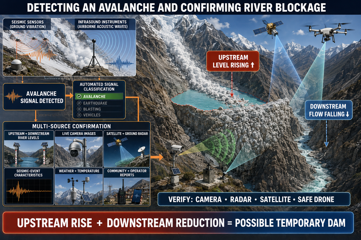
A simultaneous rise in upstream water level and reduction in downstream flow may indicate that a temporary dam has formed. The suspected blockage should be verified as quickly as possible using cameras, radar, satellite imagery or a safely operated drone.
A major ice–rock avalanche should be detected using a synchronized network of seismic sensors, geophones and infrasound instruments positioned around the potential source area, river corridor and downstream settlements. Using several stations allows the system to estimate the event’s location, direction, duration and relative magnitude while reducing false detections from local background noise.
2.1 Automated avalanche detection
Automated signal-processing and machine-learning algorithms should analyse: signal onset, amplitude, duration and frequency content; energy release and signal propagation across multiple stations; direction of arrival and estimated event location; differences between seismic and atmospheric-acoustic signals; and similarity to previously recorded avalanches and other known events.
Ice-rock avalanches commonly produce prolonged, complex signals that differ from the sharper seismic-wave arrivals associated with tectonic earthquakes. However, algorithms must be trained using local data to distinguish avalanches from earthquakes, blasting, thunder, aircraft, vehicles, construction activities, wind and sensor malfunction. Every automatic classification should include an event-location estimate, magnitude indicator, confidence score and supporting waveforms for operator review.
2.2 Immediate automated checks
When a probable avalanche is detected near a river, the monitoring platform should automatically: increase the recording frequency of upstream and downstream water-level and discharge sensors; retrieve live optical, near-infrared and thermal-camera images; task ground-based radar, where available, to scan the avalanche path and suspected blockage location; request the latest available satellite imagery while recognizing that satellite revisit time may limit immediate confirmation; compare the event with rainfall, snowfall, air temperature, snowpack, glacier-melt and antecedent river-flow conditions; check the operational status of all nearby sensors and communication links; notify the duty operator and responsible hydrometeorological and disaster-management authorities; and request observations from trained community monitors, security posts, hydropower operators, road authorities and other nearby infrastructure operators. A detected avalanche that may have reached or displaced a river should activate the Watch level, even before blockage formation is confirmed.
2.3 Hydrological evidence of blockage
The strongest hydrological indication of a new river blockage is a simultaneous or sequential: rise in water level upstream of the suspected obstruction; reduction or cessation of downstream flow; expansion of an upstream impoundment; change in the normal relationship between upstream and downstream discharge; rapid increase in the calculated volume of stored water; or abnormal delay in the expected downstream arrival of the river flow.
These changes should be evaluated using rates of change rather than a single water-level value. The analysis must account for normal flow-travel time, tributary inflows, rainfall, hydropower operations and any controlled releases.
A downstream reduction in flow alone is insufficient to confirm blockage because an avalanche may damage a gauge, interrupt telemetry or divert water away from the monitoring station. The system should therefore check battery condition, telemetry status, sensor health and observations from redundant stations before interpreting missing or declining data as a real hydrological change.
2.4 Rapid visual and remote-sensing verification
A suspected blockage should be verified as quickly as possible through two or more independent sources:
- Fixed cameras: Optical and thermal cameras can show avalanche debris entering the river, backed-up water, an expanding impoundment, reduced downstream flow, seepage, overtopping or erosion.
- Ground-based radar: Radar can detect surface movement and topographic change during darkness, cloud, fog or snowfall, depending on instrument configuration and terrain visibility.
- Water-level and discharge sensors: Upstream–downstream differences provide continuous evidence of impoundment growth and downstream flow reduction.
- Drone reconnaissance: A pre-authorized drone may inspect the blockage from a safe flight path and transmit georeferenced images or video. Drone deployment must not expose personnel to avalanche, landslide, flood-wave or wave-run-up hazards.
- Satellite observations: Optical or Synthetic Aperture Radar imagery can confirm the avalanche path, debris extent, blockage location and impounded-water area when sufficiently recent data are available.
- Trusted field observations: Trained observers may report visible flow interruption, water accumulation or unusual river behaviour from predetermined safe observation points. No person should enter the suspected blockage or inundation zone for verification.
Satellite acquisition or human field inspection should not delay escalation when continuous ground instruments already provide strong, multi-sensor evidence of blockage formation.
2.5 Confirmation and escalation criteria
The platform should classify the situation according to the strength of available evidence:
| Classification | Minimum indicative evidence | Operational action |
|---|---|---|
| Avalanche detected | Multi-station seismic or infrasound detection near a river | Activate Watch; increase monitoring and begin verification |
| Blockage suspected | Avalanche detection plus either upstream rise, downstream-flow reduction or preliminary visual/radar evidence | Maintain intensive monitoring; notify duty authorities and initiate rapid reconnaissance |
| Blockage probable | Consistent hydrological anomaly supported by a second independent sensor or observation | Prepare breach and flood-routing scenarios; place downstream authorities and communities on standby |
| Blockage confirmed | Direct visual/radar evidence or a sustained upstream rise and downstream reduction confirmed by multiple independent instruments | Activate Warning; begin continuous impoundment and dam-stability assessment |
| Failure underway | Overtopping, dam erosion, breach initiation, sudden lake drawdown or rapid downstream surge | Activate Emergency Warning and issue immediate CAP-based alerts |
The final thresholds must be site-specific and established through baseline monitoring, hydraulic modelling, historical-event analysis and field validation.
2.6 Assessment after blockage confirmation
Once a blockage is confirmed, the system should estimate: the geographical location and approximate dimensions of the natural dam; the type and likely stability of the blocking material; upstream inflow and residual downstream outflow; the rate of impoundment growth; current and projected impounded-water volume; dam freeboard and estimated time to overtopping; evidence of seepage, piping, settlement or erosion; possible breach-development scenarios; expected downstream flood-wave arrival times; and settlements, infrastructure and evacuation routes at risk.
These parameters should be continuously updated and fed into hydraulic or flood-routing models. A confirmed blockage and growing impoundment should activate the Warning level. Detection of overtopping, breach initiation, rapid impoundment drawdown or a sudden downstream surge should trigger an Emergency Warning and immediate dissemination through the approved Common Alerting Protocol procedure.
3.0 Monitoring water accumulation behind the blockage
Once a blockage is identified, continuous monitoring should determine: the location, height, width and estimated volume of the temporary dam; the composition of the dam, including ice, snow, rock, soil and debris; the rate at which water is accumulating; the expanding area and depth of the impounded water; seepage through or around the blockage; overtopping potential; additional avalanche or landslide activity; and the probability of partial or complete dam failure.
Automatic water-level sensors should be installed upstream and downstream of historically active blockage locations. Sensors must have redundant telemetry and power supplies because an avalanche or flood may destroy the nearest station or interrupt communications.
3.1 Monitoring Water Accumulation Behind the Blockage
Once a river blockage is confirmed, the monitoring system should shift immediately from event detection to continuous assessment of the temporary dam, the growing impoundment and the likelihood of overtopping or failure. Because ice–rock and debris dams can change rapidly, observations should be updated continuously and evaluated against pre-established warning thresholds.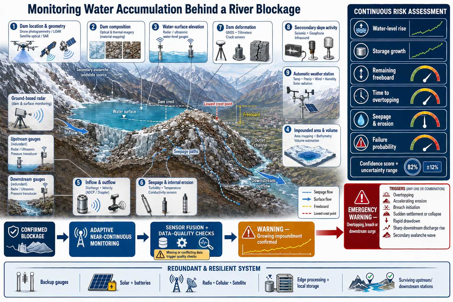
3.2 Parameters requiring continuous monitoring
The monitoring system should determine: the geographical location, crest elevation, height, width, length and estimated volume of the temporary dam; the composition of the dam, including the approximate proportions of ice, snow, rock, soil, sediment and woody debris; the stability, permeability and degree of consolidation of the blocking material; upstream inflow and residual flow through, over or around the blockage; the rate of water-level rise and impounded-water accumulation; the expanding surface area, depth and estimated volume of the impoundment; the remaining freeboard between the water surface and the lowest point of the dam crest; the estimated time until overtopping; seepage through, beneath or around the blockage; deformation, settlement, cracking, slumping or erosion of the dam; development or enlargement of an outlet channel; continuing glacier, avalanche, landslide or rockfall activity; and the probability and potential consequences of partial or complete dam failure.
3.3 Measurement methods
No single instrument can measure all required parameters. The monitoring network should therefore combine complementary ground-based, airborne and satellite observations.
| Monitoring parameter | Principal measurement methods | Operational significance |
|---|---|---|
| Dam location and geometry | Drone photogrammetry or LiDAR, fixed cameras, ground-based radar, satellite imagery and pre-event terrain models | Defines dam dimensions, crest elevation and potential storage capacity |
| Dam composition | High-resolution optical and thermal imagery, radar observations and safely obtained field evidence | Helps assess permeability, melting, erosion resistance and failure behaviour |
| Water-surface elevation | Radar or ultrasonic gauges, pressure transducers, calibrated cameras and GNSS-referenced observations | Measures the rate of impoundment growth and remaining freeboard |
| Impounded area and volume | Image segmentation, surveyed terrain, digital elevation models and reservoir elevation–area–volume relationships | Determines stored water volume and potential breach magnitude |
| Inflow and outflow | Upstream and downstream discharge gauges, velocity sensors and hydraulic calculations | Shows whether storage is increasing and how rapidly overtopping may occur |
| Seepage and internal erosion | Downstream flow, turbidity, temperature and conductivity sensors; thermal cameras; visual inspection from safe locations | May indicate water movement through the dam, piping or erosion |
| Dam deformation | Ground-based radar, GNSS, tiltmeters, crack sensors, image correlation and repeated drone surveys | Detects settlement, lateral movement, cracking or structural instability |
| Secondary slope activity | Seismic, geophone and infrasound networks, radar, cameras and satellite observations | Identifies additional avalanches or landslides that could enlarge the dam or generate displacement waves |
Estimates of dam composition and internal structure will often remain uncertain because direct inspection may be unsafe. All estimates should therefore include an uncertainty range and confidence rating.
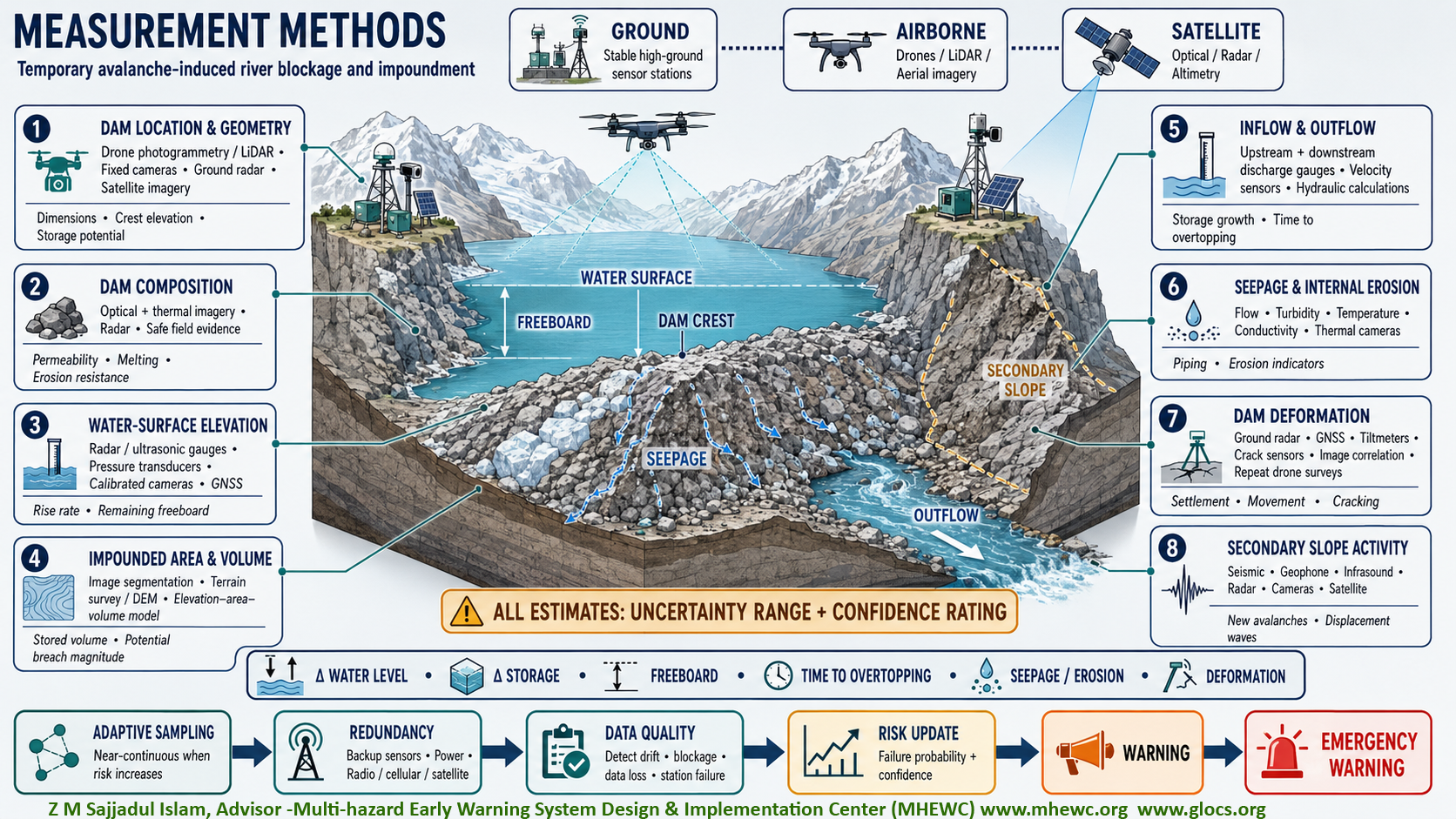
3.4 Monitoring water-level rise and impoundment growth
Automatic water-level sensors should be installed in advance upstream and downstream of historically active or high-probability blockage locations. Stations should be placed on stable, elevated ground outside expected avalanche, wave-run-up and flood-inundation zones.
The system should calculate: water-surface elevation and its rate of change; the difference between upstream and downstream water levels; impounded surface area and volume; net accumulation rate; remaining dam freeboard; and estimated time to overtopping.
The approximate change in impounded volume can be calculated from the balance between upstream inflow, downstream outflow, seepage and other losses. The calculation should be updated whenever new water-level, discharge or terrain data become available. Because the reservoir shape and inflow rate may change, the estimated time to overtopping should be presented as a continuously updated range rather than a fixed prediction.
A rapidly increasing water level, accelerating storage rate or sharply declining freeboard should trigger progressively higher monitoring and warning actions.
3.5 Monitoring seepage and erosion
Some flow through or around a temporary dam may occur without immediate failure. However, the following changes may indicate progressive instability: sudden appearance or acceleration of seepage; increasing downstream flow without controlled overtopping; rising turbidity or sediment concentration in seepage water; formation of new wet areas on the downstream dam face; localized melting of ice-rich material;enlargement of cracks, holes or subsurface flow paths;subsidence or collapse of the dam surface;erosion at the dam margins; anddevelopment of a concentrated outlet channel.
Thermal cameras may help identify water emerging through colder or warmer portions of the dam, while turbidity and conductivity sensors can indicate changing seepage conditions. Cameras alone cannot confirm internal erosion or piping; suspected internal failure should therefore be evaluated using downstream flow changes, dam deformation, seismic signals and other independent evidence.
3.6 Monitoring overtopping potential
The system should compare the impounded-water elevation with the lowest part of the dam crest. Overtopping potential increases when: the water level approaches the crest; upstream inflow increases because of rainfall, snowmelt or glacier melt; additional avalanche material displaces water; a secondary avalanche or landslide generates an impulse wave; the dam settles or its crest elevation declines; or seepage and erosion reduce the effective width or stability of the dam.
Overtopping does not always result in catastrophic failure, but flow over an unconsolidated ice, snow, sediment or debris dam can rapidly erode a channel and initiate a breach. Monitoring should therefore focus on both the start of overtopping and any acceleration in channel widening, downcutting or outflow.
3.7 Adaptive monitoring frequency
Under normal conditions, sensors may transmit data at predefined intervals. Once blockage formation is suspected or confirmed, the platform should automatically shorten the sampling and transmission interval. Monitoring should become near-continuous when: water accumulation accelerates; freeboard falls below an approved threshold; seepage or erosion increases; dam deformation is detected; intense rainfall or rapid warming is forecast; another avalanche or landslide occurs; or overtopping begins.
Cameras should switch to rapid image capture or continuous video, and downstream gauges should operate at their highest safe reporting frequency. The monitoring platform should automatically highlight rates of change, threshold exceedances and disagreement between sensors.
3.8 Redundant power, telemetry and sensor placement
Each critical measurement should have at least one independent backup. Redundancy should include: multiple upstream and downstream gauges; solar power with battery storage; protected backup batteries; radio, cellular and satellite communication pathways; edge-based data processing and local storage; alternative relay stations outside the hazard corridor; and more than one camera or observation angle where terrain permits.
A station closest to the blockage may be destroyed, submerged or disconnected. For this reason, secondary stations should be located sufficiently far upstream and downstream to survive a breach while still detecting impoundment growth and flood-wave propagation.
If communication with the central platform is interrupted, the edge system should continue recording data, evaluating thresholds and issuing authorized local warnings. Data should be synchronized with the central platform after communication is restored.
3.9 Data-quality and equipment-health checks
The system should continuously distinguish genuine hydrological change from equipment failure. Automated checks should identify: implausible or unchanging sensor values; abrupt data loss; disagreement between neighbouring gauges; declining battery voltage; communication failure; sensor drift or burial; camera movement or obstruction; and damage caused by an avalanche, ice, sediment or floodwater. Loss of a station near a confirmed blockage should itself generate an equipment-failure alert and prompt immediate comparison with redundant instruments. Missing data must never be interpreted automatically as zero flow or dam failure.
3.10 Failure-probability assessment
The probability of partial or complete dam failure should be updated using a combination of: impounded-water volume; water-level rise and filling rate; remaining freeboard; dam height, width, geometry and composition; ice content and expected melting; inflow, seepage and outflow; overtopping and erosion rates; dam deformation and settlement; additional avalanche or landslide probability; rainfall, temperature and snowmelt forecasts; and observed performance of comparable temporary dams.
Each assessment should include a confidence score and a clear explanation of the evidence driving the risk classification. Model results should be reviewed by trained hydrologists, geologists or duty officers whenever time and communication permit.
3.11 Warning escalation
A confirmed blockage with a growing impoundment should activate the Warning level. Authorities should immediately initiate breach modelling, downstream flood routing, evacuation-readiness measures and continuous communication with exposed communities.
An Emergency Warning should be issued when multi-sensor evidence indicates: imminent or active overtopping; rapidly accelerating erosion; breach initiation; sudden dam settlement or collapse; rapid impoundment drawdown; a sharp increase in downstream discharge; or a secondary avalanche-generated wave capable of overtopping the dam.
Extreme, multi-sensor-confirmed failure signals should trigger immediate automated notification and location-specific Common Alerting Protocol messages under the approved operating procedure.
4.0 Detecting breach initiation
A temporary dam composed of ice, rock and loose debris can fail suddenly. Possible warning indicators include: rapidly rising impounded-water levels; overtopping of the blockage; increasing seepage; internal erosion or piping; visible deformation or settlement; cracking or movement within the dam; a sudden fall in upstream water level; and an abrupt rise in downstream discharge.
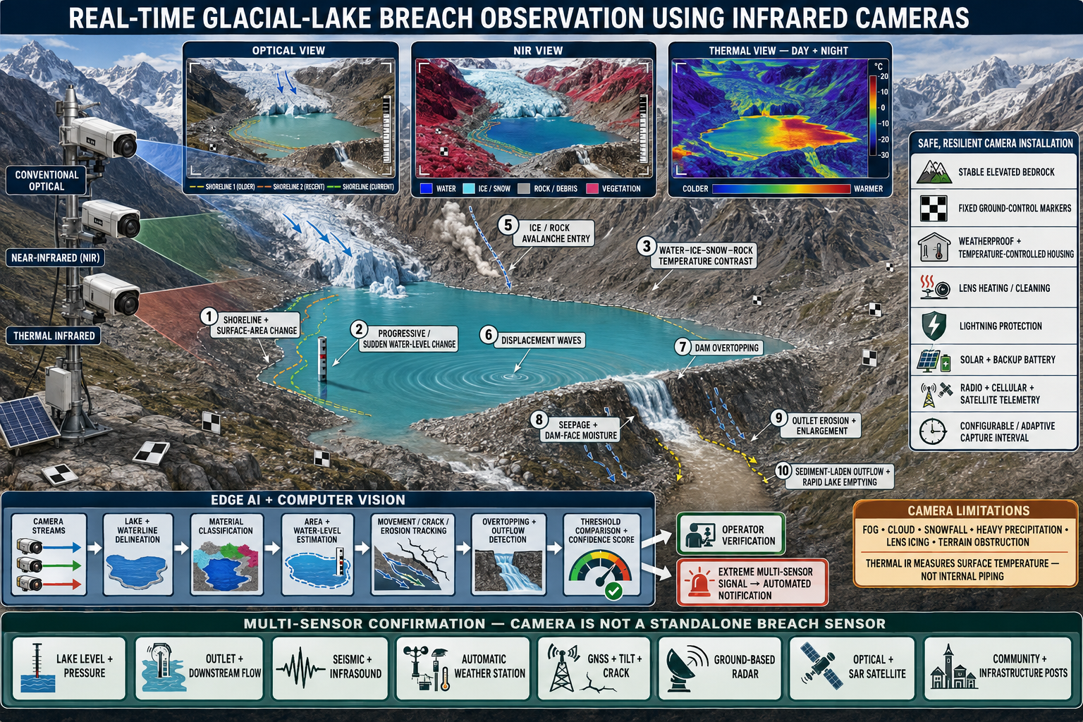
When breach indicators are detected, the monitoring platform should automatically calculate the probable flood-wave magnitude, downstream travel time, inundation extent and exposed population and infrastructure. The results should immediately reach the responsible hydrometeorological agency, disaster-management authority and Emergency Operations Centre.
5.0 Downstream flood-wave monitoring
A cascade of river-level sensors should be installed along the downstream corridor. These stations should continuously measure water level, discharge, flow velocity and, where feasible, sediment or debris concentration.
The system should compare observed conditions with pre-established thresholds for: bankfull flow; Monitor the flood-wave crest, peak discharge, water-level recession and any subsequent surges; channel-carrying capacity; bridge and culvert clearance; settlement inundation; hydropower and utility infrastructure; road and border-crossing disruption; and evacuation requirements.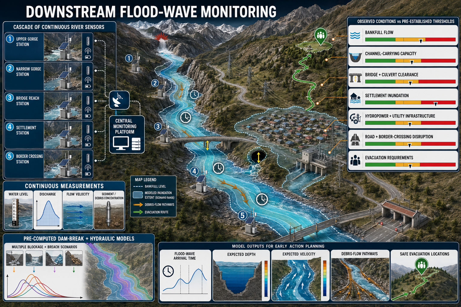
Dam-break and hydraulic models should be prepared in advance for multiple blockage and breach scenarios. These models must identify flood-wave arrival times, expected depths, velocities, debris-flow pathways and safe evacuation locations.
6.0 Automated warning levels
6.1 Automated Transboundary Siren and Multi-Channel Warning Network
An automated siren and voice-warning network should be established along the entire transboundary drainage corridor to protect settlements exposed to glacial lake outburst floods, flash floods and other glacier-related hazards. Siren installations in participating countries should operate as an interconnected network using satellite links and redundant UHF/VHF radio communication. This architecture should enable warnings generated upstream to be transmitted rapidly to downstream Emergency Operations Centres, local authorities, security agencies and communities across national boundaries.
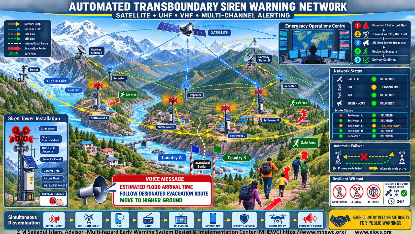
Each warning station should combine high-output sirens with voice-capable loudspeakers. Siren locations, output levels and directional coverage should be determined through acoustic modelling, field testing and settlement-level exposure mapping to ensure that warnings are clearly audible throughout every potentially affected community, including remote areas and locations with difficult mountain terrain.
An alert should begin with a distinctive siren tone, followed by clear and repeated voice instructions in locally understood languages. Messages should communicate, as applicable: the type and location of the hazardous event; the settlements and river corridors potentially affected; the estimated flood-wave arrival time and associated uncertainty; designated evacuation routes; identified safe areas, assembly points and higher ground; immediate protective actions required from the population; and the time of the next official update.
The network should remain operational continuously and be capable of automatic, remote and local activation at any time. Authorized Emergency Operations Centres should be able to activate all sirens within an affected corridor, selected downstream zones or individual warning stations. Automatic activation may be initiated when approved technical thresholds are exceeded and the required verification and authorization conditions are satisfied. Manual activation controls should also be available at national, subnational and community levels for use when central systems or communication links are unavailable.
Every siren station should have redundant and independently functioning communication pathways, including UHF/VHF radio, satellite communication and, where available, cellular and internet connectivity. The radio network should use appropriately positioned repeaters and a resilient ring or mesh configuration so that the failure of one station or communication route does not interrupt transmission to the remaining network. If the primary communication channel fails, the system should automatically switch to an alternative route and continue transmitting the warning.
Each installation should also have redundant power supplies, including: a solar photovoltaic system with battery-bank storage; grid electricity where available; an IPS, uninterruptible power supply or equivalent backup system; and sufficient stored power to maintain communication, control and warning functions during prolonged electricity outages.
Local control units should store pre-approved warning tones and multilingual voice-message templates so that stations can continue issuing warnings during failures of grid electricity, mobile networks, internet services or central servers. Scheduled automated tests, remote equipment diagnostics and routine community audibility tests should verify the operational status of sirens, loudspeakers, batteries, solar panels, radio links and local activation controls.
A centralized dissemination dashboard should display the real-time status of every warning station and communication channel. It should confirm whether each station has received, acknowledged and transmitted the alert and should identify failures affecting sirens, loudspeakers, power supplies or communication links. If acknowledgment or successful transmission is not confirmed within the agreed period, the platform should automatically: activate an alternative satellite, UHF, VHF, cellular or internet route; notify designated primary and alternate technical focal points; escalate the alert to the responsible Emergency Operations Centres; repeat the siren and voice message at approved intervals; and record all activation, acknowledgment, failure and recovery events in an auditable system log.
Emergency messages should be disseminated simultaneously through all approved channels rather than relying on sirens alone. These channels should include sirens and loudspeakers, cell broadcast, SMS, radio, television, mobile applications, security and emergency-service communication networks, drone-supported communication, community-warning systems and direct notification of local authorities and designated focal points.
The transboundary siren network should be governed by agreed protocols defining activation authority, technical thresholds, message formats, language requirements, acknowledgment periods, escalation procedures, testing schedules, maintenance responsibilities and cost-sharing arrangements. Although participating countries should retain authority for issuing public warnings and protective-action instructions within their respective territories, cross-border transmission of verified life-saving information should occur immediately and should not be delayed by diplomatic or administrative procedures.
Through this interconnected and redundant architecture, detection of an upstream GLOF or related hazard can automatically initiate rapid warnings throughout the downstream corridor, giving exposed populations the maximum available time to evacuate to designated safe areas or higher ground.
6.2 A graduated warning protocol should be established:
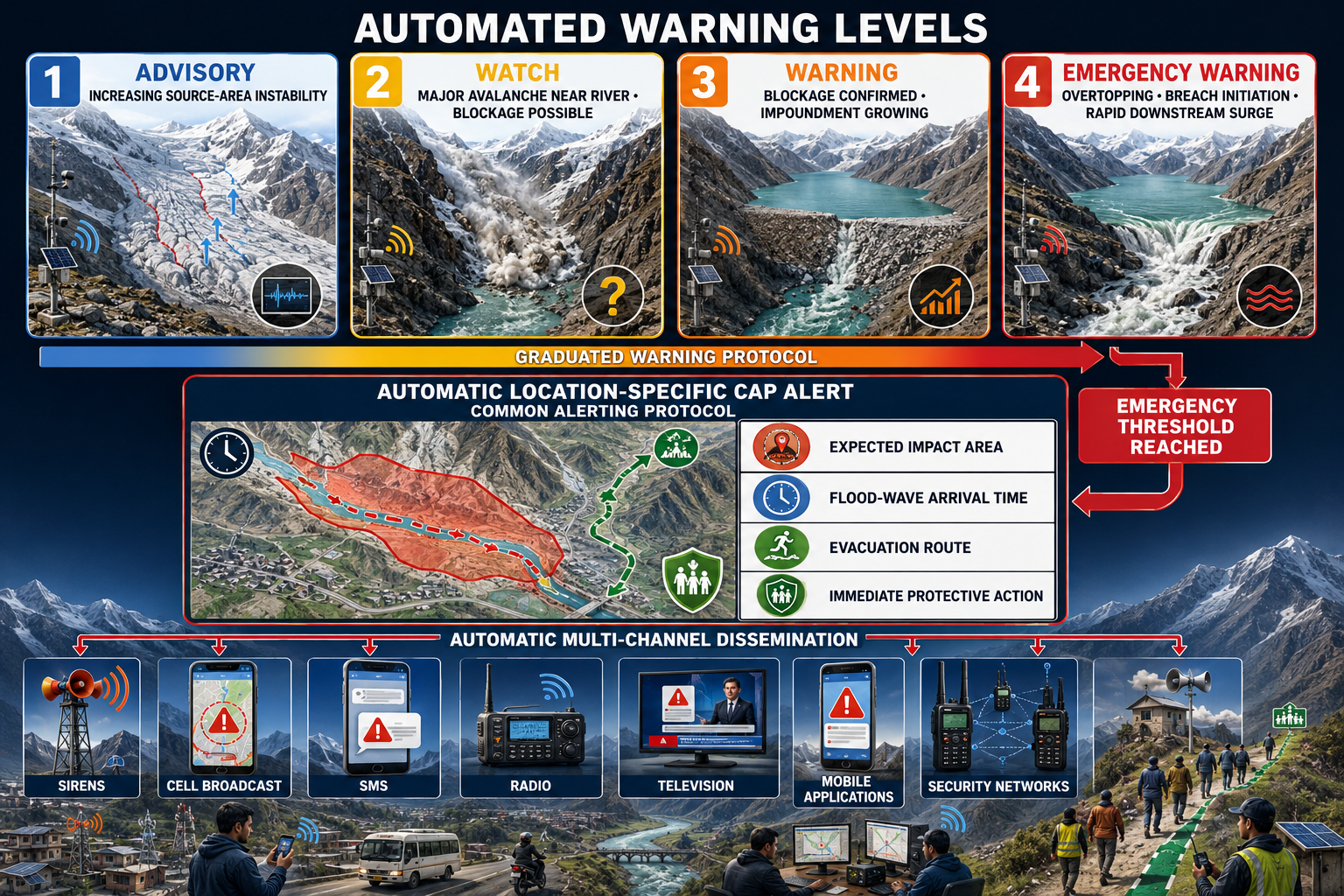
- Advisory: Increasing instability is detected in an avalanche-source area.
- Watch: A major avalanche has occurred near a river, and blockage formation is possible.
- Warning: A river blockage and growing impoundment have been confirmed.
- Emergency warning: Overtopping, breach initiation or a rapid downstream surge has been detected.
Once an emergency threshold is reached, a location-specific Common Alerting Protocol message should be automatically disseminated via drone radio, drone-based CAP alerts & automated sirens, cell broadcast, SMS, radio, television, mobile applications, security networks, and community-warning systems. Messages must specify the expected impact area, flood-wave arrival time, evacuation route and immediate protective action.
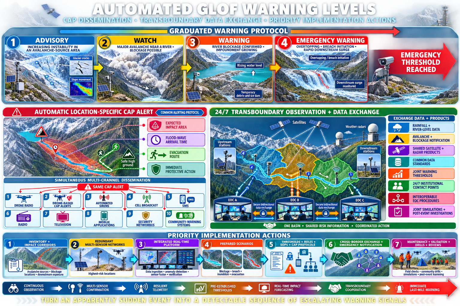
Because Himalayan river basins and avalanche-source areas frequently cross national boundaries, the framework also calls for formal transboundary observation and data-sharing arrangements. These should include automated exchange of rainfall and river-level data, rapid notification of avalanches and river blockages, shared satellite and radar products, common data standards, jointly agreed warning thresholds, designated 24-hour institutional contact points, interoperable Emergency Operations Centre procedures, joint simulations and collaborative post-event investigations. ICIMOD’s preliminary assessment of the Lhende Khola disaster similarly emphasizes the need for real-time risk information and stronger regional cooperation. ICIMOD rapid assessment.
Priority implementation actions are therefore to: establish a national and transboundary inventory of avalanche-source areas, potential river-blockage locations and downstream impact corridors; install redundant multi-sensor monitoring networks at the highest-risk locations; develop an integrated platform for real-time data ingestion, anomaly detection, sensor fusion and operational verification; prepare blockage, breach, inundation and evacuation scenarios before emergencies occur; approve warning thresholds, institutional responsibilities, standard operating procedures and CAP-based dissemination protocols; establish formal cross-border data-exchange and emergency-notification mechanisms; and conduct regular system maintenance, field validation, community drills, institutional simulations and post-event reviews.
The principal objective is to transform a sudden and apparently unexpected avalanche-induced flood into a detectable sequence of escalating warning signals. Continuous observation, multi-sensor confirmation, resilient telemetry, pre-established thresholds, real-time impact forecasting, transboundary cooperation and immediate last-mile communication can provide critical warning time and substantially reduce future loss of life, infrastructure damage and disruption across Himalayan river corridors.
Avalanche-induced river-blockage outburst floods require a dedicated, multi-layered monitoring system capable of detecting the entire hazard sequence from slope or glacier destabilization and avalanche initiation to river blockage, water impoundment, dam failure and downstream flood-wave propagation. No single instrument can reliably detect every stage. Continuous monitoring must therefore integrate satellite observations, ground-based sensors, seismic detection, hydrological stations, automated cameras, forecasting models and community observations.
A graduated warning protocol should connect each stage of the avalanche–blockage–breach sequence with predefined thresholds, institutional responsibilities and protective actions. Thresholds should be location-specific and established using baseline observations, historical events, terrain analysis, hydraulic modelling and community evacuation requirements.
6.3 Warning-level decision matrix
| Warning level | Indicative trigger | Principal operational actions |
|---|---|---|
| Advisory | Increasing movement, cracking or instability is detected in an avalanche-source area, hanging glacier or unstable rock–ice slope. | Increase monitoring frequency; verify sensor quality; notify technical agencies and duty officers; review equipment, communication and evacuation readiness. |
| Watch | A major avalanche has occurred near or entered a river, and blockage or water displacement is possible but not yet confirmed. | Activate rapid sensor interrogation; examine upstream and downstream flow; obtain camera, radar or drone observations; place the Emergency Operations Centre and downstream authorities on standby; prepare location-specific CAP messages. |
| Warning | A river blockage and growing upstream impoundment have been confirmed, creating a credible threat of overtopping or dam failure. | Activate the Emergency Operations Centre; begin continuous dam and impoundment monitoring; run breach and flood-routing models; notify exposed communities; prepare or initiate precautionary evacuation; close high-risk river corridors and crossings. |
| Emergency warning | Overtopping, rapid erosion, breach initiation, sudden impoundment drawdown or a rapid downstream surge has been detected. | Issue immediate CAP-based alerts; activate automated ( loude-speaker based across) siren networks (UHF/VHF networked) the lake, downstream settlements & key installations, and via every available dissemination channel; order evacuation to designated safe areas; initiate emergency response and continuous flood-wave tracking. |
6.4 Advisory
An Advisory should be issued when monitoring identifies abnormal changes in an avalanche-source area, including:8 accelerating glacier or slope movement; development or widening of cracks; increased rockfall or icefall activity; rapid temperature change or intense rainfall; abnormal seismic or infrasound activity; weakening of a hanging glacier or unstable rock–ice mass; or convergence of several moderate-confidence indicators.
An Advisory primarily activates institutional readiness. It should trigger increased observation frequency, technical review of the detected instability, confirmation of sensor performance and notification of responsible hydrometeorological, geological and disaster-management agencies.
Authorities should verify that downstream gauges, cameras, automted sirens, communication links and backup power systems are operational. Community focal points may receive preparedness information, but the message should clearly state that an avalanche or flood has not yet been confirmed.
6.5 Watch
A Watch should be issued when a significant avalanche or slope failure has occurred near, across or directly into a river and blockage formation, water displacement or debris-flow transformation is possible.
The system should immediately: increase the sampling frequency of seismic, infrasound, camera and hydrological sensors; compare upstream and downstream water levels and discharge; estimate whether avalanche material reached the river; inspect the suspected location using cameras or ground-based radar; deploy a drone when it can be operated safely; assess the possibility of a displacement wave or immediate downstream surge; place downstream authorities, infrastructure operators and community-warning networks on standby; and prepare CAP messages for rapid release if blockage is confirmed.
A Watch communicates that a dangerous event has occurred and that conditions may deteriorate rapidly. People in the immediate river corridor should stop entering riverbanks, bridges, gorges and other exposed locations.
6.6 Warning
A Warning should be issued when multi-sensor evidence confirms that avalanche material has blocked or substantially obstructed the river and water is accumulating upstream.
Confirmation may include: a sustained rise in upstream water level; reduced or interrupted downstream flow; visual, radar or drone evidence of a physical obstruction; measurable expansion of an upstream impoundment; declining dam freeboard; increasing seepage, deformation or erosion; or hydraulic-model results indicating a credible overtopping or breach threat.
The Warning level should activate continuous monitoring, breach-scenario modelling, flood-wave routing and impact forecasting. Emergency Operations Centres, local governments, security services, hydropower operators, road authorities and community-warning structures should move to full operational readiness.
Communities with short evacuation times or limited access to safe areas may need to begin precautionary evacuation at the Warning stage rather than waiting for visible breach initiation. These arrangements should be defined in advance through location-specific evacuation plans.
6.7 Emergency warning
An Emergency warning should be issued when observations indicate that dam failure or a destructive downstream surge is imminent or already underway. Emergency indicators include: overtopping of the temporary dam; rapid outlet enlargement or accelerating erosion; breach initiation or partial dam collapse; sudden settlement of the dam crest; rapid drawdown of the impounded water; a sharp increase in downstream water level, velocity or discharge; a secondary avalanche-generated displacement wave; or direct detection of a fast-moving downstream flood surge. The Emergency warning must communicate one unambiguous instruction: evacuate immediately using the designated route to the specified safe area. People should not approach the river, bridges or the blockage to observe the event.
6.8 Automated decision and authorization process
The warning platform should automatically: receive and quality-check data from all connected sensors; detect anomalies and calculate rates of change; assign confidence scores to individual observations; fuse camera, hydrological, seismic, radar, weather and community observations; compare the results with approved warning thresholds; recommend or activate the applicable warning level; generate a location-specific CAP message; disseminate the authorized message through all available channels; and
6.9 record the data, decision, authorization and delivery status in an auditable log.
Advisory, Watch and Warning recommendations should normally be reviewed by an authorized duty officer when communication and lead time permit. However, an authorized officer should always be able to escalate the warning manually when professional judgement or trusted field information indicates that conditions are more dangerous than the automated classification suggests.
6.10 Safeguards for automatic emergency activation
A single camera image, AI classification or failed water-level sensor should not independently generate an Emergency warning. Automatic emergency activation should require a pre-approved combination of independent evidence, such as: visual or radar detection of overtopping combined with rapidly increasing outflow; rapid impoundment drawdown combined with rising downstream water level; breach detection supported by seismic or infrasound activity; a downstream surge detected by two sequential river stations; or another site-specific combination demonstrating imminent danger with high confidence.
Where the predicted flood-wave arrival time is too short for operator verification, an extreme, multi-sensor-confirmed signal should trigger immediate automated notification under the approved standard operating procedure. Duty officers should be notified simultaneously, but their acknowledgement should not delay the life-saving message.
6.9 CAP message requirements
The Common Alerting Protocol message should include: a unique alert identifier; issuing authority and issue time; hazard type and warning level; urgency, severity, certainty and confidence; current event status and expected development; mapped impact area and named settlements; expected flood-wave arrival time or time range; likely impacts on people, bridges, roads and infrastructure; evacuation routes, safe areas and assembly points; immediate protective actions; prohibited actions, such as approaching the river; message validity and expiry time; contact or verification source; and links between the original alert and subsequent updates or cancellations.
Messages should be short, action-oriented, geographically specific and available in relevant local languages. They should use plain language, accessible formats and consistent hazard terminology.
A typical emergency instruction may state: EMERGENCY WARNING: The temporary river blockage at [location] has begun to fail. A destructive flood wave may reach [settlement] at approximately [time]. Evacuate immediately through [route] to [safe area]. Do not use riverside roads or bridges. Follow instructions from local authorities.
6.10 Multi-channel dissemination
CAP messages should be distributed simultaneously through redundant communication channels: drone-supported radio relays; drone-based CAP alerts or mobile loudspeaker systems; AI-enabled automed drone-siren, AI-enabled multi-channel drone radio, AI-enabled automated big sirens and loudspeaker voice-warning units; cell broadcast; SMS; radio; television; mobile applications and digital platforms; police, military, border-security and infrastructure communication networks; and community-warning systems, including volunteers, public-address systems, bells, flags and door-to-door notification.
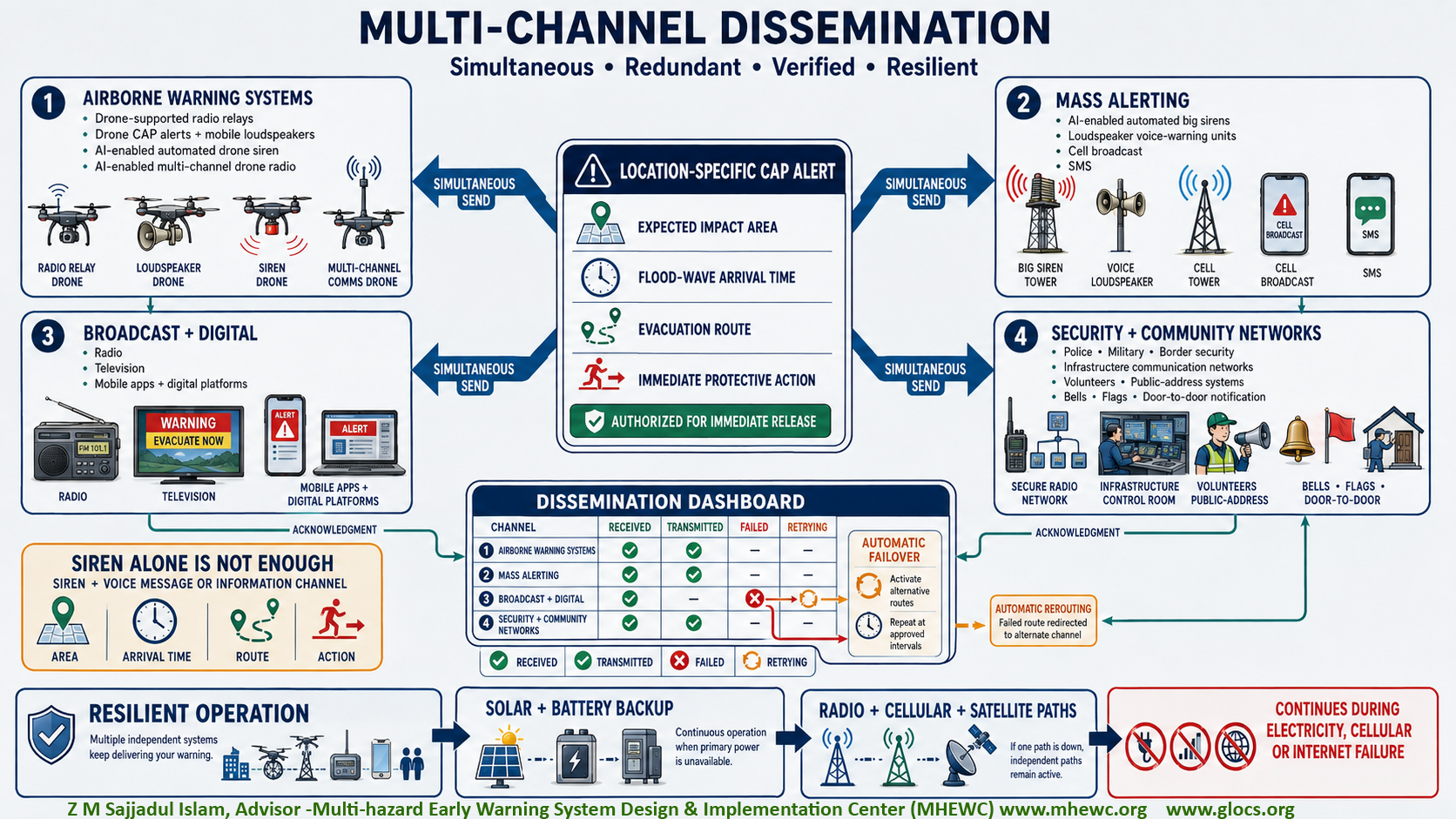
Sirens should be integrated with voice-capable loudspeakers and complemented by other warning channels. An interconnected siren network should provide adequate audible coverage to every settlement potentially exposed to GLOFs or other glacier-related hazards. Voice messages should clearly communicate the estimated flood arrival time, designated evacuation routes, and immediate protective actions, including movement to identified safe areas or higher ground.
The automated siren network should remain continuously operational ( with UHF/VHF network) and capable of activation at any time. Each installation should have redundant power supplies, including a solar photovoltaic system with battery-bank storage and an IPS or equivalent backup system. Redundant communication and local activation mechanisms should also enable warnings to be issued during grid power, cellular network, or internet failures. The dissemination dashboard should confirm which channels successfully received or transmitted the alert. If a primary channel fails, the platform should automatically activate alternative routes and repeat the message at approved intervals.
6.11 Warning updates, de-escalation and all-clear
Warnings should be updated whenever the hazard level, impact area, arrival time or recommended action changes. Each update should reference the original CAP alert to prevent conflicting messages. De-escalation should require confirmation from several independent observations and authorization by the designated authority. Temporary stabilization or declining water level should not be interpreted as safety if the dam remains unstable or secondary avalanches are possible. An all-clear should be issued only after specialists confirm that the immediate threat has passed, downstream conditions are stable, and authorities have assessed the safety of evacuation routes and affected areas. The all-clear message should state whether restrictions remain in force and when residents may return.
7.0 Transboundary observation and data exchange
Because many Himalayan headwaters, glacial lakes, avalanche-source areas and downstream impact corridors extend across national boundaries, Nepal and relevant upstream and downstream riparian countries should establish formal, continuous and operational arrangements for transboundary observation, data exchange and emergency notification. These arrangements should be supported by bilateral or regional agreements, technical protocols and standard operating procedures defining institutional responsibilities, data custodianship, exchange frequency, quality-control requirements, alert procedures, access rights, system maintenance and financing.
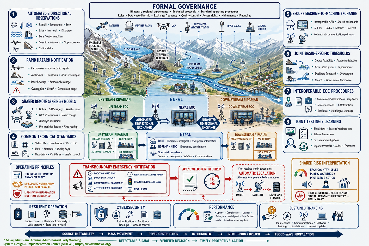
The transboundary system should include:
- Automated, bidirectional exchange of observations, including rainfall, temperature, snow conditions, glacial-lake levels, river levels and discharge, dam or outlet conditions, seismic and infrasound signals, slope movement and the operational status of monitoring stations.
- Rapid notification of hazardous events, including earthquakes, non-tectonic seismic events, avalanches, landslides, rock-ice collapses, river blockages, sudden lake-level changes, overtopping, breach initiation and abnormal downstream surges.
- Shared remote-sensing and modelling products, including optical and Synthetic Aperture Radar imagery, weather-radar information, UAV observations, terrain-change analysis, blockage assessments and pre-modelled breach and flood-routing scenarios.
- Common technical standards, covering station identifiers, coordinates, geodetic reference systems, UTC timestamps, measurement units, metadata, quality flags, uncertainty ranges, confidence scores and version control.
- Secure machine-to-machine data exchange, supported by interoperable application programming interfaces, shared dashboards and redundant cellular, radio, satellite and internet communication pathways.
- Jointly developed, basin-specific technical thresholds for source-area instability, avalanche detection, river-flow interruption, upstream impoundment, declining freeboard, overtopping, breach initiation and downstream flood-wave detection.
- Interoperable Emergency Operations Centre procedures, including common alert classifications, map layers, situation reports, CAP-compatible message templates, escalation procedures and multilingual warning information.
- Joint simulations, seasonal readiness tests, after-action reviews and post-event investigations to improve thresholds, models, operating procedures and institutional coordination.
Transboundary emergency notifications should contain the event location and time, event type and status, supporting observations, confidence level, potentially affected river corridors, forecast arrival times, expected impacts, recommended alert level and time of the next update. Every notification should require electronic acknowledgment. If acknowledgment is not received within the agreed time, the system should automatically escalate the message to alternate focal points and activate redundant communication routes.
Operational information should flow directly between designated technical agencies and national or subnational Emergency Operations Centres. Diplomatic notifications may proceed in parallel but should not delay the exchange of life-saving information. In Nepal, the protocol should clearly define the roles of DHM as the hydrometeorological and cryosphere-information focal point, NDRRMA and the National Emergency Operation Centre as emergency-coordination focal points, and relevant seismic, geological, satellite and communications institutions as specialist data providers. Equivalent primary and alternate 24/7 focal points should be designated in each participating country and tested regularly.
Joint technical thresholds should support consistent interpretation of risk, while each country should retain responsibility for issuing public warnings and ordering protective action within its territory. A high-confidence, multi-sensor-confirmed signal should be transmitted immediately, even if initially marked as preliminary. Further technical verification should follow without delaying downstream preparedness or evacuation.
The system should remain operational during electricity, telecommunications or internet failure through backup power, redundant telemetry, local data storage and store-and-forward transmission. Cybersecurity, authentication, audit logs, data backups and access controls should be incorporated without creating barriers to urgent life-safety information.
Performance should be monitored using indicators such as station uptime, data completeness, transmission latency, notification-delivery and acknowledgment rates, false and missed alerts, and the time between detection, verification and downstream warning. Dedicated budgets should cover monitoring-station maintenance, communication services, software, training, simulations and periodic updating of flood scenarios.
The objective is not necessarily to predict every avalanche, but to ensure that each stage source-area instability, mass movement, river obstruction, upstream water accumulation, overtopping or breach, and downstream flood-wave propagation—produces a detectable signal, a verified operational decision and a timely protective action. Continuous observation, automated anomaly detection, rapid cross-border verification, pre-modelled impact scenarios and immediate downstream communication can provide critical warning time and substantially reduce loss of life and damage.
Nepal incident At 8:37 AM local time on 26 August 2026 :
Probable Cause and Preliminary Impacts of the Incident
The precise cause of the disaster remains under investigation. However, initial satellite and seismic evidence indicates that the flood was most likely triggered by a massive rock-ice avalanche or landslide, rather than by a conventional earthquake or glacial-lake outburst.
As of 26 August 2026, at least 98 deaths had been confirmed 95 in Nepal and three in Tibet, China although authorities warned that the toll could rise. Reports on missing persons continue to change. A live update placed the number reported missing at 579, including 54 United States nationals and 33 United Kingdom nationals. Separate government reports indicated that 44 Nepal Army personnel, 28 Nepal Police personnel, 13 Armed Police Force personnel and 60 hydropower-project workers were also out of contact. Foreign and domestic tourists constitute a significant proportion of those reported missing. Because these lists are still being reconciled and may overlap, the figures should be treated as provisional. BBC live update Associated Press
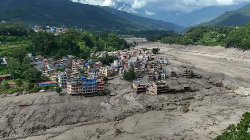
Soruce : getty image
The flood caused extensive infrastructure damage. Preliminary assessments indicate that at least 19 motorable bridges and approximately 40 kilometers (25 miles) of paved roads were damaged, along with settlements, government facilities, border infrastructure, hydropower projects and electricity-transmission systems. BBC damage update
Likely cause: A landslide-triggered flood
At approximately 8:37 a.m. local time on 26 August 2026, an enormous mass of glacier ice, rock and sediment descended into the Lhende Khola River, a tributary of the Bhote Koshi River.
CNN subsequently reported that the USGS had determined that the seismic signal was produced by the exceptionally powerful landslide itself, rather than by a tectonic earthquake. The landslide reportedly involved slope failure; instead, the massive rock-ice collapse generated an earthquake-like seismic signal. Nevertheless, the complete sequence of events remains under scientific investigation. CNN analysis
Satellite imagery indicates that a substantial section of a glacier broke away at an elevation of approximately 5,200 meters and fell about 1,200 meters onto the valley floor. The resulting rock-ice avalanche may have temporarily blocked or displaced the Lhende Khola, generating a sudden surge of water, sediment and boulders through the Bhote Koshi and Trishuli river systems. Scientists have not yet determined whether the flood resulted principally from river blockage and sudden release, direct displacement of water, transformation of the avalanche into a debris flow, or a combination of these processes. Reuters
Climate-change context
The disaster occurred within the rapidly warming Hindu Kush Himalayan region, where accelerated glacier loss, thawing permafrost and repeated freeze-thaw cycles are destabilizing high-elevation ice and rock slopes. Meltwater can penetrate fractures in glaciers and mountainsides, reducing their stability and increasing the likelihood of rockfalls, ice collapses and cascading debris flows. Climate change is also increasing the potential for extreme precipitation and high-altitude flooding.
Unlikely cause: A glacial-lake outburst flood
Nepal is highly vulnerable to glacial-lake outburst floods, which occur when water stored behind an ice or moraine dam is suddenly released. Nevertheless, preliminary satellite analysis indicates that no major glacial lake was situated directly upstream along the identified flood path. A conventional glacial-lake outburst is therefore considered an unlikely primary cause of this incident.
This conclusion remains provisional and should be verified through high-resolution satellite imagery, drone surveys, field investigations and hydrological reconstruction. The current evidence more strongly supports a rock–ice avalanche and landslide-triggered flood than a conventional glacial-lake outburst. CNN analysis
[ NB: The Multi-Hazard Early Warning System Design & Implementation Center (MHEWC) would welcome the opportunity to share its international experience and technical expertise at an upcoming workshop in Kathmandu, Nepal. We kindly request that MHEWC be invited to participate in the next relevant meeting or workshop. Please call +8801711979179 or email zmsajjad@gmail.com ]