Climate risk and vulnerabilities of Kenya
Kenya is highly vulnerable to climate change and multi-hazard risks due to its exposure to droughts, floods, flash floods, landslides, extreme heat, water scarcity, coastal hazards, ecosystem degradation, and climate-sensitive disease risks. The country’s vulnerability is shaped by its arid and semi-arid lands, dependence on rainfed agriculture and pastoralism, water-resource stress, rapidly growing cities, exposed river basins, Indian Ocean coastal zone, and high livelihood dependence on natural resources. Climate risk affects agriculture, pastoralism, water resources, health, infrastructure, ecosystems, and livelihoods. (Climate Change Knowledge Portal)
Kenya is highly exposed and vulnerable to climate change and multi-hazard risks due to recurrent droughts, floods, variable rainfall, water scarcity, dependence on rainfed agriculture and pastoralism, rapidly growing urban settlements, exposed river basins, coastal vulnerability, and high livelihood dependence on natural resources. The country faces major risks from droughts, flash floods, riverine and urban flooding, landslides, extreme heat, crop failure, livestock losses, coastal erosion, sea-level rise, saltwater intrusion, ecosystem degradation, food insecurity, and climate-sensitive disease outbreaks. Climate change is expected to intensify these vulnerabilities through rising temperatures, erratic rainfall, prolonged dry spells, heavier rainfall events, worsening drought stress, increased flood damage, pasture decline, water insecurity, and growing pressure on livelihoods, public health, infrastructure, ecosystems, and vulnerable rural, urban, pastoral, and coastal communities. Strengthening multi-hazard early warning systems, impact-based forecasting, drought and flood risk management, climate-resilient agriculture, pastoralist resilience, water security, coastal protection, urban drainage, disaster risk financing, and locally led adaptation is essential to reduce losses and protect Kenya’s development gains.

1. Multi-hazard exposure
Kenya’s main climate and disaster risks include droughts, floods, flash floods, landslides, extreme heat, storms, riverbank erosion, coastal flooding, sea-level rise, wildfires, land degradation, and disease outbreaks. Climate-risk assessments identify droughts, floods, changing seasonal patterns, and poorly distributed rainfall as major stressors affecting agriculture, pastoralism, water resources, infrastructure, health, and lives and property. (Climate Change Knowledge Portal)
Kenya’s risk profile differs by region. The arid and semi-arid lands of northern, eastern, and southern Kenya face recurrent drought, pasture loss, livestock mortality, food insecurity, and water scarcity. The highlands and western regions face intense rainfall, river flooding, flash floods, landslides, and soil erosion. The urban centres, especially Nairobi, Mombasa, Kisumu, Nakuru, Eldoret, and rapidly growing secondary towns, face urban flooding, drainage failure, heat stress, water demand, and informal settlement exposure. The coastal counties face sea-level rise, erosion, saltwater intrusion, storm surge, coral reef stress, and risks to ports, tourism, fisheries, and settlements.
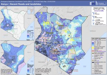
Kenya | Recent floods and landslides – DG ECHO Daily Map | 07/05/2026
2. Climate change as a development risk multiplier
Climate change is a major development risk for Kenya because it affects food security, water security, public health, infrastructure, ecosystems, pastoral livelihoods, agriculture, tourism, and public finance. Kenya’s National Climate Change Action Plan 2023–2027 prioritizes adaptation because of the severe impacts of droughts, floods, and extreme weather events. (Migration Network)
The country is increasingly experiencing compound climate shocks: drought weakens households, livestock systems, water sources, and markets; subsequent heavy rainfall can then trigger floods, landslides, crop losses, disease outbreaks, and displacement. This cycle is especially severe for communities with limited savings, low insurance coverage, weak infrastructure, and high dependence on climate-sensitive livelihoods.
3. Drought, pastoralism, and food-security vulnerability
Drought is one of Kenya’s most severe and recurrent hazards. It is especially damaging in Turkana, Marsabit, Mandera, Wajir, Garissa, Samburu, Isiolo, Baringo, West Pokot, Tana River, Kajiado, Narok, Kitui, Makueni, and parts of Laikipia and Meru. Drought reduces pasture, dries water sources, weakens livestock, increases livestock mortality, reduces milk production, depresses livestock market value, increases food insecurity, and can intensify competition over scarce grazing and water resources.
The recent drought pattern shows how climate stress is spreading beyond Kenya’s traditionally arid north and northeast. Reuters reported in 2026 that severe drought had extended into Kajiado County near Nairobi, causing major livestock losses, distress sales, pasture scarcity, and increased movement of herders in search of water and grazing; Kenya’s National Drought Management Authority warned that recurrent droughts were increasing competition for scarce resources and raising conflict risk. (Reuters)
4. Flood, flash-flood, and landslide vulnerability
Flooding is Kenya’s other major recurrent hazard. Riverine flooding affects the Tana, Athi, Nzoia, Nyando, Yala, Sondu, Ewaso Ng’iro, Turkwel, and other basins, while flash floods affect dryland riverbeds, urban drainage systems, low-lying settlements, and steep catchments. Heavy rainfall can also trigger landslides in highland and escarpment areas.
The 2024 floods demonstrated the scale of Kenya’s flood vulnerability. OCHA reported that heavy rains and flooding had killed 291 people, injured 188, left 75 missing, and displaced about 278,380 people by mid-May 2024. (OCHA) Flood impacts included damage to homes, roads, bridges, schools, health facilities, water systems, farms, livestock, and livelihoods.
5. Agriculture, livestock, and livelihood vulnerability
Agriculture and livestock are among Kenya’s most climate-sensitive systems. Rainfed farming is exposed to delayed rains, dry spells, drought, floods, pests, crop diseases, soil erosion, and heat stress. Pastoralist systems are exposed to pasture degradation, water scarcity, livestock disease, drought, invasive species, and resource conflict.
| Sub-sector | Main climate and hazard risks |
|---|---|
| Rainfed crops | Drought, erratic rainfall, delayed seasons, floods, pests, crop failure |
| Irrigated agriculture | Water scarcity, flood damage, sedimentation, salinity, infrastructure failure |
| Pastoralism | Pasture loss, water scarcity, livestock mortality, disease, conflict over resources |
| Agro-pastoral systems | Combined crop failure and livestock losses during drought or flood years |
| Fisheries | Lake-level variability, coastal ecosystem stress, flooding, warming waters |
| Rural markets | Road disruption, food-price shocks, livestock price collapse, reduced income |
Climate-risk profiles identify agriculture, water resources, energy and infrastructure, ecosystems, and health as key sectors affected by climate change in Kenya. (PreventionWeb)
6. Water security vulnerability
Water security is a central climate challenge for Kenya. Many counties already face water stress, and climate change is expected to increase pressure through rainfall variability, drought, higher evaporation, groundwater stress, river-flow variability, and growing demand from households, agriculture, livestock, cities, industry, energy, and ecosystems. The Red Cross Red Crescent Climate Centre notes that climate change will have a growing impact on water resources in Kenya, which are already under stress from population growth and rising demand. (Climate Centre)
Water vulnerability is especially high in ASAL counties, informal urban settlements, dryland pastoral areas, and coastal communities affected by salinity intrusion. Floods can contaminate water systems and damage boreholes, pipelines, latrines, water pans, and small dams, while drought can force households and livestock to travel longer distances for water.
7. Coastal, marine, and tourism vulnerability
Kenya’s Indian Ocean coast is exposed to sea-level rise, coastal flooding, storm surge, coastal erosion, saltwater intrusion, coral reef degradation, mangrove loss, and marine ecosystem stress. Coastal counties including Mombasa, Kilifi, Kwale, Lamu, Tana River, and parts of Taita-Taveta face risks to settlements, ports, tourism assets, fisheries, coastal roads, freshwater systems, and cultural heritage.
Tourism is climate-sensitive because it depends on wildlife ecosystems, coastal beaches, coral reefs, protected areas, water availability, transport access, and perceptions of safety. Drought can affect wildlife and rangelands, floods can disrupt roads and parks, and coastal erosion or reef degradation can reduce the value of beach and marine tourism.
8. Urban and infrastructure vulnerability
Kenya’s cities and towns face increasing climate risk from urban flooding, drainage failure, heat stress, water shortages, informal settlement exposure, solid-waste blockage, and infrastructure overload. Nairobi’s low-lying informal settlements and river corridors are especially vulnerable to flooding, while Mombasa faces compound urban, coastal, drainage, and sea-level-rise risks.
Critical infrastructure is exposed to both floods and drought:
| Infrastructure system | Main climate risks |
|---|---|
| Roads and bridges | Flood washouts, landslides, erosion, access disruption |
| Water systems | Drought stress, flood contamination, pipeline and borehole damage |
| Schools and health facilities | Flood damage, heat stress, service interruption |
| Energy systems | Hydropower variability, heat-driven demand, storm and flood disruption |
| Urban drainage | Flash flooding, blocked drains, informal settlement exposure |
| Ports and coastal assets | Sea-level rise, erosion, storm surge, flooding |
9. Health and social vulnerability
Climate change increases public-health risks through heat stress, malnutrition, waterborne disease, vector-borne disease, flood-related injuries, respiratory stress from dust and smoke, and disruption of health services. Drought can worsen malnutrition and water scarcity, while floods can increase diarrhoeal disease, cholera risk, malaria risk, and WASH-related health impacts.
The most vulnerable groups include pastoralists, agro-pastoralists, smallholder farmers, fishing communities, low-income urban households, informal settlers, women-headed households, children, older persons, people with disabilities, outdoor workers, displaced households, and communities living in drought-prone, flood-prone, landslide-prone, or coastal-risk areas.
10. Sector-specific vulnerability summary
| Sector | Main climate and multi-hazard risks |
|---|---|
| Agriculture and food security | Drought, erratic rainfall, floods, pests, crop failure, food-price shocks |
| Pastoralism and livestock | Pasture loss, water scarcity, livestock mortality, disease, resource conflict |
| Water resources | Drought, groundwater stress, flood contamination, river-flow variability, salinity |
| Urban settlements | Flash floods, poor drainage, heat stress, informal settlement exposure |
| Coastal zones | Sea-level rise, coastal erosion, saltwater intrusion, storm surge, reef degradation |
| Health | Heat illness, malnutrition, diarrhoeal disease, cholera risk, vector-borne disease |
| Transport infrastructure | Road washouts, bridge damage, landslides, flood disruption |
| Ecosystems and tourism | Wildlife stress, rangeland degradation, coral reef stress, forest and wetland degradation |
11. Priority resilience needs
Kenya’s resilience agenda should prioritize multi-hazard early warning systems, impact-based forecasting, drought monitoring, flood forecasting, landslide-risk mapping, climate-resilient agriculture, pastoralist livelihood protection, water-resource management, coastal-zone protection, urban drainage improvement, climate-health surveillance, disaster risk financing, and locally led adaptation.
| Priority area | Key actions |
|---|---|
| Early warning and anticipatory action | Impact-based warnings for drought, floods, heat, landslides, storms, livestock stress, and disease outbreaks |
| Drought and pastoralist resilience | Rangeland restoration, water-point management, fodder reserves, livestock insurance, mobility-route protection |
| Flood-risk management | River-basin forecasting, drainage upgrading, floodplain zoning, settlement risk reduction |
| Climate-smart agriculture | Drought-, flood-, and heat-tolerant crops; agro-climate advisories; crop insurance; soil conservation |
| Water security | Groundwater monitoring, water harvesting, aquifer protection, drought contingency planning, WASH resilience |
| Urban resilience | Stormwater drainage, solid-waste management, heat-risk planning, informal settlement upgrading |
| Coastal resilience | Mangrove restoration, coastal-risk mapping, saltwater-intrusion monitoring, resilient coastal infrastructure |
| Risk financing | Contingency finance, forecast-based financing, scalable cash transfers, insurance, resilient recovery funding |
Natural Disaster Risk Hotspots
Click on individual images for larger view
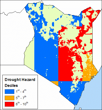 | 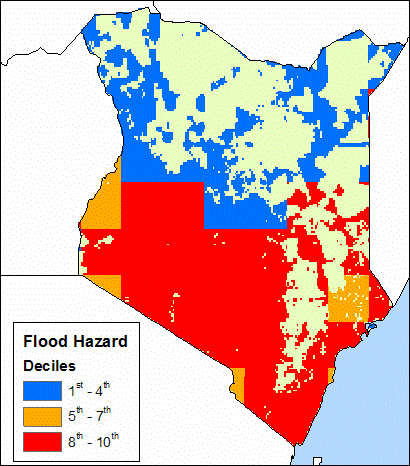 | 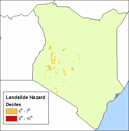 | ||
| Droughts | Floods | Landslides |
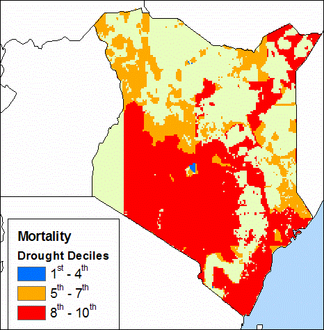
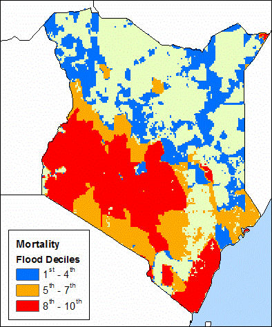
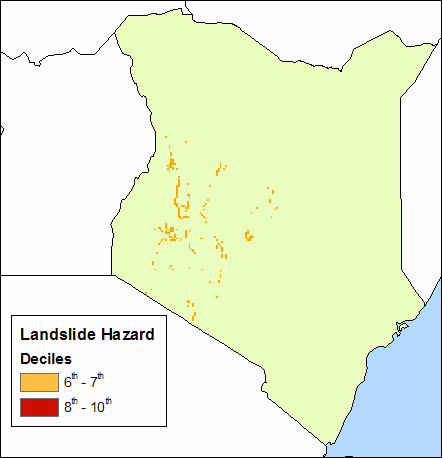
Natural Disaster Risk Hotspots (Weighted by Mortality)
Click on individual images for larger view
 |  |  | ||
| Droughts | Floods | Landslides |
EM-DAT Information (1964 – 2004)
| Disaster | # of Events | Total Killed | Avg. # Killed | Total Affected | Avg. # Affected |
| Cyclone | 1 | 50 | 50 | 0 | 0 |
| Drought | 11 | 165 | 15 | 16,312,600 | 1,482,964 |
| Earthquake | 1 | 0 | 0 | 0 | 0 |
| Flood | 17 | 524 | 31 | 1,203,508 | 70,795 |
| Volcano | – | – | – | – | – |
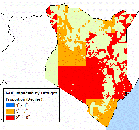
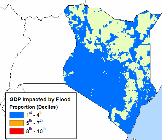
Natural Disaster Risk Hotspots (Weighted by Proportion of GDP Impacted)
Click on individual images for larger view
 |  | |
| Droughts | Floods |
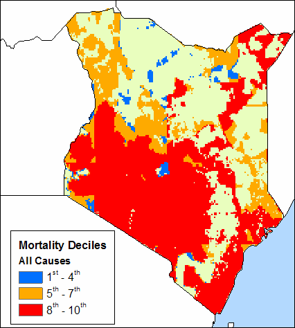
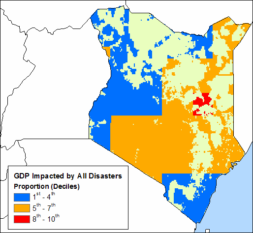
Multi-Hazard Disaster Risk Hotspots (All Hazards combined and weighted by Mortality and Proportion of GDP Impacted)
Click on individual images for larger view
 |  | |
| Mortality | GDP |
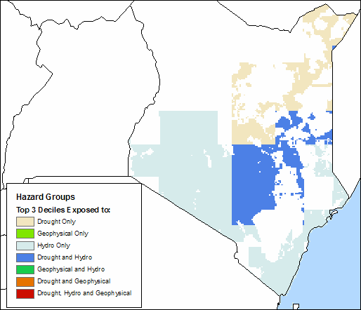
Multi-Hazard Disaster Risk Hotspots by Hazard Groups (Top Three Deciles)
Click on individual images for larger view
 |
Observations
Droughts and floods are the most significant hazards affecting Kenya. The maps exclude hazard impacts in non-agricultural areas where small populations were masked out of the maps. Although droughts and floods show large impacts when weighted by mortality, the effects of droughts are more severe, particularly in the north. When weighted by GDP impact, droughts pose a substantially higher risk than floods throughout the country.
National Disaster Management Authority (NDMA)

The National Drought Management Authority (NDMA) is a State Corporation established by the NDMA Act, 2016. The Act mandates the Authority to exercise overall coordination over all matters relating to drought risk management and to establish mechanisms, either on its own or with stakeholders, that will end drought emergencies in Kenya.
NDMA has operational offices in 23 Arid and Semi-Arid Lands (ASAL) counties, which cover over 80% of Kenya’s landmass. The Authority also has satellite offices with limited functions in Ijara, Mwingi and Moyale, where distances from the county offices are long. There are plans to expand to more drought prone counties over the next few years.
Websites:
a)
b) https://knowledgeweb.ndma.go.ke/
The National Drought Management Authority (NDMA) is a public body established by the National Drought Management Authority (NDMA) Act, 2016. It previously operated under the State Corporations Act (Cap 446) of the Laws of Kenya by Legal Notice Number 171 of November 24, 2011. The Act gives the NDMA the mandate to exercise overall coordination over all matters relating to drought risk management and to establish mechanisms, either on its own or with stakeholders, that will end drought emergencies in Kenya.
NDMA Departments
Policy Documents
Vision 2030 Sector Plan for Drought Risk Management and EDE – 2013-17
1 file(s) 1.54 MB
Vision 2030 Development strategy for ASALs
1 file(s) 2.87 MB
Vision 2030 Abridged version
1 file(s) 3.32 MB
Strategic Plan 2018-2022
1 file(s) 6.98 MB
Sessional Paper on National Policy for Development of ASALs
1. TECHNICAL SERVICES
The Technical Services Department is composed of four (4) divisions namely:-
a) Drought Information
- Developing and maintaining drought information systems.
- Coordinating national and county food security assessments.
- Processing drought early warning information for use by stakeholders.
b) Drought Resilience
- Coordinate of drought risk reduction and building of long-term resilience to drought.
- Promote the capacity building of community planning units in participatory disaster risk assessments.
- Facilitate formulation, implementation, M&E of strategic risk reduction programmes, projects, and initiatives.
c) Drought Contingency Planning and response
- Develop strategies and oversee coordination and implementation of drought response programmes and projects based on drought management cycle and contingency planning.
- Consolidation of county plans into national drought contingency plans.
- Establishment and maintenance of a national drought response capacity database.
d) Resource Mobilization and Advocacy
- Mobilise resources for the Authority through the engagement of collaborating Development Partners and organised community groups.
- Build and sustain effective partnerships both within and without Government and identify Development Partners with interest to support the Authority.
- Develop advocacy programmes that engage local communities in key decisions which ensure their active participation in drought management at their level.
2. SUPPORT SERVICES
This department has five (5) divisions namely:
a)Finance and Accounts
b) Human Resource and Administration
c) Information and Communication Technology
d) Supply Chain
e) Media and Public Relations
3. POLICY, PLANNING AND RESEARCH
a) Develop and review of the national strategy on drought management.
b) Convene joint planning and prioritisation by stakeholders through joint fora Providing framework for coordinating financing of public sector role in national response.
c) Initiate and participate in organisational performance reviews and business process improvement programmes.
d) Coordinate research in the field of drought management.
4. INTERNAL AUDIT
The Internal Audit Department supports the Authority attain best practices and standards of governance and control for enhanced transparency and accountability in the management and utilisation of public resources.
This Department provides value adding internal auditing services that promote the effectiveness of the risk management, control and governance processes in the Authority.
It’s role is to assist the NDMA Board and Management in meeting their objectives and discharge their responsibilities by providing an appraisal of the adequacy and effectiveness of the controls, risk management and corporate governance processes set up by management.

01. Early warning systems
NDMA has put in place a robust early warning system that provides timely information on impending droughts.

02. Drought contingency planning
NDMA has developed and implemented drought contingency plans that guide the response to drought emergencies.
This series of short-term, project-based interventions were being carried out at a time when drought periods were becoming increasingly frequent and intense, directly affecting the household food security and livelihoods of more than ten million people. The government therefore recognised the need to strengthen the sustainability and quality of drought management in Kenya by establishing the National Drought Management Authority (NDMA).
The NDMA provides a platform for long-term planning and action, as well as a mechanism for solid coordination across Government and with all other stakeholders. The Authority has established offices in 23 ASAL counties considered vulnerable to drought.

03. Risk reduction measures
NDMA promotes and supports the implementation of risk reduction measures such as water harvesting, reforestation, and soil conservation. These measures enhance the resilience of communities and ecosystems to drought.

04. Coordination and collaboration
NDMA coordinates with various stakeholders such as government agencies, non-governmental organizations, and communities to implement drought management interventions.

How NDMA offer Solutions
The history of Kenya’s work on drought management goes back to 1985, with the design of a drought contingency planning system in Turkana. In the early 1990s this system was extended to other arid districts with the support of the Netherlands government. It was then expanded further by the Emergency Drought Recovery Project (from 1992) and its successor, the ALRMP, both of them supported by the World Bank. By end of Phase II of the ALRMP, the drought management system was covering 28 arid and semi-arid districts (now 23 counties).
DROUGHT CONTINGENCY PLANNING AND RESPONSE
The National Drought Management Authority (NDMA) in Kenya defines drought contingency planning and response as a systematic process of preparing for, responding to, and recovering from droughts.
This process involves identifying potential drought risks, assessing the impact of drought on various sectors, and developing appropriate measures to mitigate the impact of drought on vulnerable populations.
Drought contingency planning also involves the development of early warning systems and contingency plans to guide the response to drought when it occurs.
The response to drought may involve various interventions, such as the provision of water and food relief, the implementation of livestock off-take programs, and the promotion of alternative livelihood strategies.
The ultimate goal of drought contingency planning and response is to reduce the impact of drought on vulnerable populations and enhance their resilience to drought and other climate-related risks.
NDMA is mandated with ;
By focusing on drought contingency planning and response, the NDMA plays a critical role in addressing food insecurity and reducing the impact of drought on vulnerable populations in Kenya.
Specific interventions are necessary in response to the early warning information provided at different stages of the drought cycle. The actions, in combination with preparations made by communities, can significantly reduce drought impacts and safeguard the gains of drought resilience. The Authority;
Mainstreams drought risk reduction and climate adaptation into planning
The National Drought Management Authority (NDMA) in Kenya operationalizes the Drought Contingency Fund within the proposed National Drought Contingency Fund.
The Drought Contingency Fund is a mechanism for financing drought risk management interventions, including early warning systems, preparedness measures, and emergency response activities. The NDMA is responsible for the management and administration of the fund, which is financed through various sources, including government allocations, donor funding, and contributions from other stakeholders.
The NDMA ensures that the fund is used in accordance with the approved guidelines and is transparently managed and reported on. The fund is used to support various interventions, such as the provision of water and food relief, the implementation of livestock off-take programs, and the promotion of alternative livelihood strategies.
By operationalizing the Drought Contingency Fund, the NDMA plays a critical role in enhancing preparedness and reducing the impact of drought on vulnerable populations in Kenya.
Facilitates multi-stakeholder contingency planning in each county
Provides contingency finance to counties against their plans
Provides guidance and standards for all drought practitioners in Kenya
Kenya Drought Risk Management KnowledgeWeb
