Climate risk and vulnerabilities of Cambodia
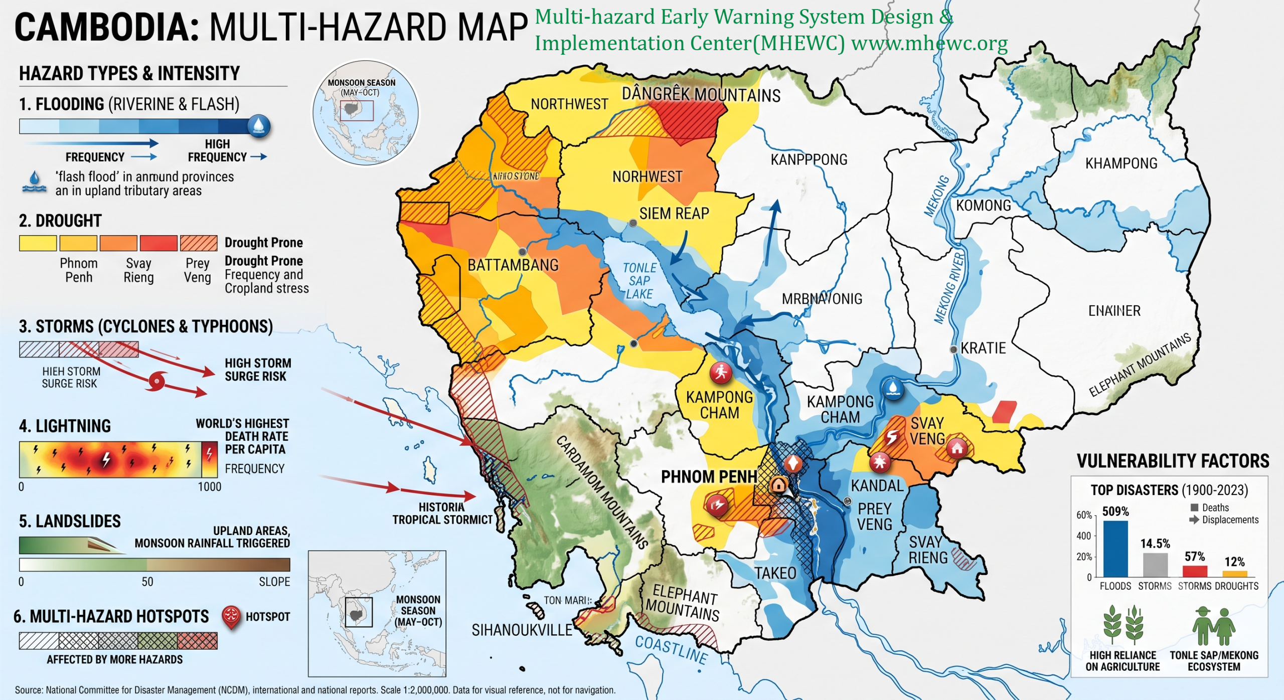
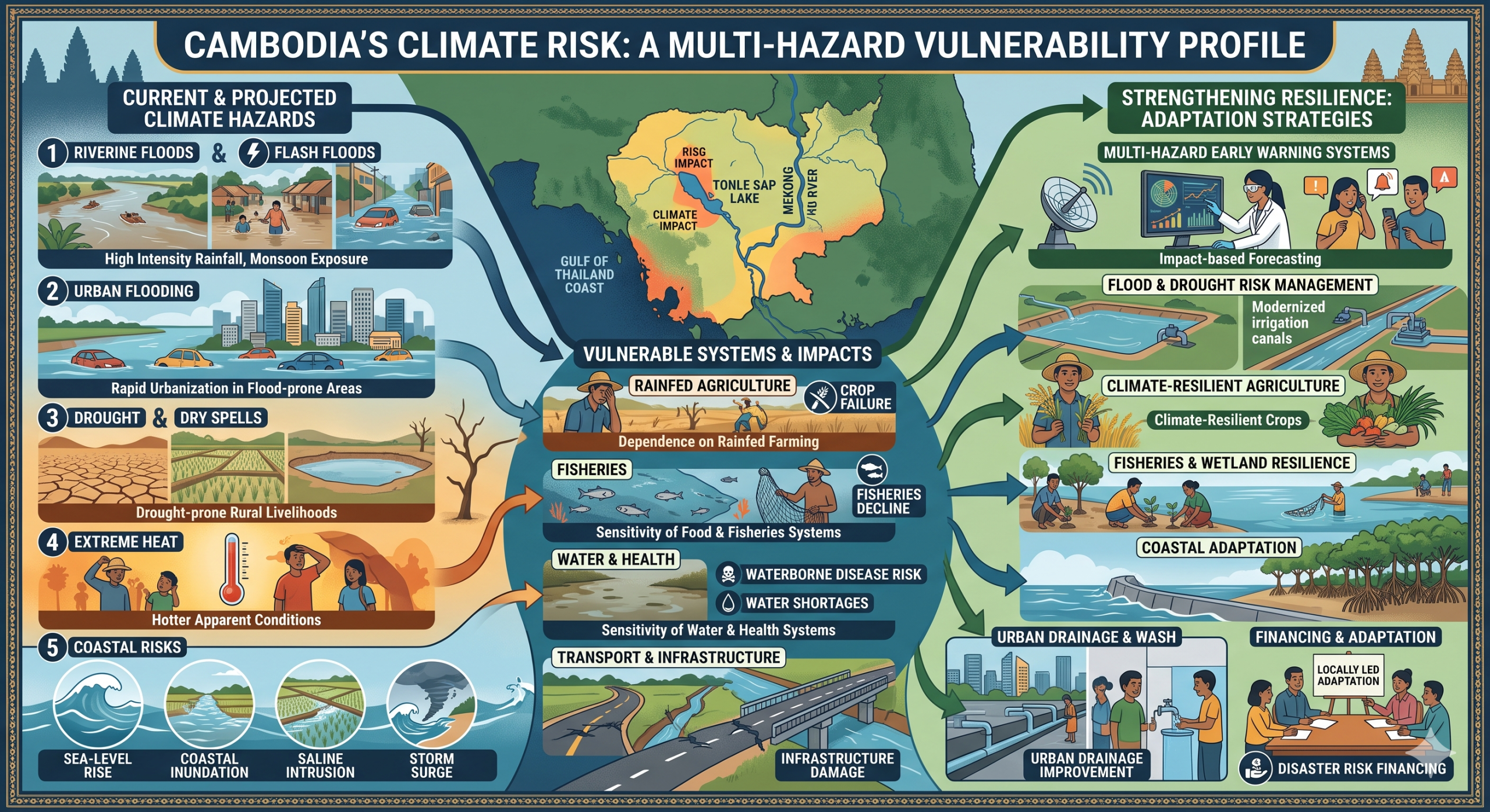


Cambodia is highly exposed and vulnerable to climate change and multi-hazard risks due to its monsoon climate, dependence on rainfed agriculture, exposure to the Mekong River and Tonle Sap flood systems, drought-prone rural livelihoods, rapid urbanization in flood-prone areas, coastal exposure, and sensitivity of food, fisheries, water, health, transport and infrastructure systems to climate shocks. The country faces major risks from riverine floods, flash floods, urban flooding, drought, dry spells, extreme heat, intense rainfall, windstorms, storm surge, coastal inundation, saltwater intrusion, crop failure, fisheries decline, water shortages, waterborne disease risks and infrastructure damage. Climate change is expected to intensify these vulnerabilities through higher temperatures, hotter apparent conditions, more intense precipitation, more persistent flood and drought extremes, sea-level rise, saline intrusion, declining agricultural and fisheries productivity, public-health stress and growing pressure on vulnerable rural, urban and coastal communities. Strengthening multi-hazard early warning systems, impact-based forecasting, flood and drought risk management, climate-resilient agriculture, irrigation modernization, fisheries and wetland resilience, coastal adaptation, WASH resilience, urban drainage improvement, disaster risk financing nd locally led adaptation is essential to reduce losses and protect Cambodia’s development gains.
Cambodia is highly vulnerable to climate change and multi-hazard risks because of its monsoon climate, high dependence on rainfed agriculture, exposure to the Mekong River and Tonle Sap flood systems, drought-prone rural livelihoods, low-lying floodplain settlements, coastal exposure along the Gulf of Thailand, and sensitivity of water, food, fisheries-lying floodplain settlements, coastal exposure along the Gulf of Thailand, and sensitivity of water, health, transport and urban systems to climate shocks. The country’s major hazards include floods, flash floods, drought, dry spells, intense rainfall, storms, windstorms, lightning, heat stress, riverbank erosion, saltwater intrusion, coastal inundation, storm surge, crop failure, fisheries decline, waterborne disease risks and infrastructure damage. Cambodia’s 2024 climate-risk profile notes that flooding and drought across the Mekong River Valley and Tonle Sap basin have increased in frequency and intensity and a(PreventionWeb)while sea-level rise and inundation will increasingly threaten coastal zones. citeturn930410view3
1. Multi-hazard exposure
Cambodia’s risk profile is dominated by floods, droughts and storms, with floods as the predominant economic risk. GFDRR’s disaster-risk-finance diagnostic reports expected annual disaster losses of about US$74.2 million, equivalent to 0.7% of GDP, with floods accounting for 55% of total annual economic losses and droughts for 28%. It also reports that between 1991 and nearly 11.9 million people and caused about US$1.4 billion in damage. citeturn930410view2
The hazard geography varies across the country. The Mekong floodplain, Tonle Sap basin and lowland rice-growing areas face recurrent riverine flooding, flash floods, drainage congestion and waterlogging. North-western and central provinces face drought, rainfall variability, crop stress and groundwater pressure. Phnom Penh and secondary towns face increasing urban flood exposure due to rapid development and inadequate drainage. Koh Kong, Kampot, Kep and Preah Sihanouk face coastal flooding, storm surge, saltwater intrusion, coastal erosion and sea-level-rise risks.
2. Climate change as a development risk multiplier
Climate change is a major development risk for Cambodia because it affects agriculture, fisheries, water resources, health, transport, urban growth, coastal zones, disaster finance, trade and poverty reduction. The World Bank’s Cambodia Country Climate and Development Report states that Cambodia faces one of the world’s highest levels of exposure to floods and extreme heat, and that climate change could (PreventionWeb)opment challenges, including growth, trade, debt and poverty-reduction risks. citeturn930410view1
Cambodia’s 2024 climate-risk profile projects higher minimum and maximum temperatures by mid-century, hotter apparent conditions due to humidity, more intense precipitation, and increasing coastal threats from sea-level rise and inundation. These projected changes are particularly important because Cambodia’s rural(PreventionWeb) and water management are strongly tied to seasonal rainfall and river flows. citeturn930410view3
3. Flood, flash-flood and urban vulnerability
Flooding is Cambodia’s most frequent and damaging hazard. Seasonal river flooding is part of the country’s natural hydrology, but damaging floods occur when intense rainfall, Mekong high flows, Tonle Sap backflow, saturated soils, drainage congestion, blocked canals and settlement in flood-prone areas combine. Floods damage homes, roads, bridges, schools, health centres, irrigation systems, rice fields, markets, livestock assets, water points and sanitation facilities.
Urban flood risk is increasing. GFDRR notes that cities and towns in Cambodia’s Mekong floodplain continue to grow, often without adequate land-use planning, resulting in increasing urban risk, regular flooding and waterlogging. This is particularly important for **Phnom Penh, Battambang, Siem Reap, Kampong Cham, Kandal and other rapidly growing t, solid-waste management and floodplain zoning are critical resilience needs. citeturn930410view2
4. Drought, dry spells and water-scarcity vulnerability
Drought is Cambodia’s second-largest disaster-risk driver and is especially damaging to agriculture and rural livelihoods. UNDP’s disaster-financial-preparedness analysis reports that droughts severely affect agricultural productivity, especially rice production, and account for nearly one-fifth of rice losses between 1997 and 2010. It identifies Prey Veng, Kandal, Kampoanteay Meanchey and Kampong Speu as among the most drought-prone provinces. citeturn930410view5
Drought affects households through crop failure, reduced irrigation water, lower groundwater recharge, reduced pond and canal storage, livestock water stress, food shortages, rising food prices and increased disease risks. During the 2015–2016 El Niño period, drought affected 2.5 million people in 25 provinces, with damage to crops and poor communities depenhealth centres reported increased disease cases linked to drought conditions. citeturn930410view5
5. Agriculture, rice systems and food-security vulnerability
Agriculture is one of Cambodia’s most climate-sensitive sectors, particularly rainfed rice production, which depends on seasonal rainfall, river-fed irrigation, flood timing, soil moisture and stable monsoon conditions. Smallholder farmers are especially vulnerable because flood or drought shocds from two rice crops per year to only one, threatening livelihood security. citeturn930410view2
| Sub-sector | Main climate and hazard risks |
|---|---|
| Rainfed rice | Drought, delayed rains, dry spells, floods, waterlogging, heat stress, crop failure |
| Irrigated rice | Low river flows, canal failure, drought, flood damage, sedimentation, pumping costs |
| Vegetables and cash crops | Heat stress, water shortages, pest outbreaks, storm damage, post-harvest losses |
| Livestock | Heat stress, water shortages, flood-related disease, feed scarcity |
| Smallholder livelihoods | Reduced harvests, debt, food insecurity, migration pressure, asset depletion |
| Food markets | Crop losses, transport disruption, price volatility, reduced household purchasing power |
Cambodia’s adaptation priorities therefore include modernizing and expanding irrigation, diversifying from high-risk crops toward climate-resilient and higher-value crops, strengthening extension services, improving early warning systems and improvi(PreventionWeb)infrastructure. These recommendations are highlighted in the World Bank CCDR. citeturn930410view1
6. Tonle Sap, Mekong fisheries and ecosystem vulnerability
The Tonle Sap and Mekong systems are central to Cambodia’s food security, fisheries, agriculture, transport, wetlands and rural livelihoods. Climate change threatens these systems through altered flood pulses, drought, extreme rainfall, sediment changes, water-temperature stress, ecosystem degradation and pressure on fish migration and spawning habitats. The 2024 climate profile identifies the Mekong River Valley and Tonl(PreventionWeb)eas where flood and drought risks have increased and are expected to persist. citeturn930410view3
Fisheries vulnerability is especially important because fish and aquatic resources are central to nutrition and rural livelihoods. Climate impacts on fisheries can reduce household protein intake, income from capture fisheries, aquaculture productivity and resilience of floating and lakeside communities. The World Bank CCDR recommends improving fishe(PreventionWeb)ting climate-resilient aquaculture and protecting critical mangrove habitats. citeturn930410view1
7. Coastal-zone, sea-level-rise and saltwater-intrusion vulnerability
Cambodia’s coastal zone faces increasing risks from sea-level rise, coastal inundation, storm surge, saltwater intrusion, coastal erosion, mangrove degradation and coastal flooding. UNDP’s Cambodia NAPA identifies key climate hazards as flash floodin(UNDP Climate Change Adaptation), coastal-zone inundation, drought and low flows, windstorms and storm surge. citeturn930410view4
Coastal risks affect Koh Kong, Kampot, Kep and Preah Sihanouk, including fishing communities, mangroves, coastal agriculture, tourism assets, ports, roads, water points and low-lying settlements. Saltwater intrusion can reduce freshwater availability, damage crops, affect aquaculture and fisheries, and increase household water insecurity in coastal and estuarine areas.
8. Heat stress, health and WASH vulnerability
Rising temperatures and humidity increase heat stress, dehydration, reduced labour productivity, crop water demand, livestock stress and public-health risks. Heat risks are especially important for outdoor workers, farmers, construction workers, elderly people, children, people with chronic illness and poor households living in poorly ventilated housing. Cambodia is expected t(PreventionWeb)nimum and maximum temperatures and hotter apparent conditions by mid-century. citeturn930410view3
Floods and droughts also increase health risks through unsafe water, diarrhoeal disease, dengue and malaria risk in some areas, malnutrition, sanitation failure, injuries during floods and disruption of health services. Cambodia’s NAPA identifies increased disease and health problems, water shortage, groundwater(UNDP Climate Change Adaptation) agricultural production as major livelihood and human vulnerability impacts. citeturn930410view4
9. Infrastructure, transport and settlement vulnerability
Cambodia’s infrastructure is highly exposed to flood, storm and drainage risks. Critical systems include rural roads, bridges, culverts, irrigation canals, dikes, schools, health posts, markets, water-supply systems, sanitation facilities, river ports, urban drainage and electricity infrastructure. Floods and storms often disrupt transport, trade, school attendance, health access and market connectivity, especially in rural and riverine areas.
GFDRR highlights that risk-reduction measures are not keeping pace with rapid urbanization, especially in floodplain towns, where poor land-use planning increases flood and waterlogging risk. It also notes that smallhelihood insecurity when disaster impacts reduce crop cycles and productivity. citeturn930410view2
10. Sector-specific vulnerability summary
| Sector | Main climate and multi-hazard risks |
|---|---|
| Agriculture and food security | Floods, drought, dry spells, heat stress, crop pests, rice losses, income decline |
| Water resources | Drought, low flows, groundwater depletion, flood contamination, saltwater intrusion |
| Fisheries and aquaculture | Altered flood pulse, drought, water-temperature stress, habitat degradation, fish-stock decline |
| Coastal zones | Sea-level rise, storm surge, coastal inundation, saltwater intrusion, mangrove loss |
| Health and WASH | Heat stress, diarrhoeal disease, dengue/malaria risk, unsafe water, sanitation failure |
| Urban areas | Flooding, drainage congestion, waterlogging, informal settlement exposure, heat stress |
| Infrastructure | Road and bridge damage, irrigation failure, dike damage, school and clinic disruption |
| Ecosystems | Wetland degradation, mangrove loss, forest stress, erosion, biodiversity decline |
| Public finance | Disaster-response costs, crop losses, infrastructure repair, fiscal shock from major events |
11. Social vulnerability
The most vulnerable groups include smallholder farmers, land-poor rural households, fishing communities, floating and lakeside communities, coastal households, informal urban residents, women-headed households, children, older persons, people with disabilities, migrant workers, and households with limited access to irrigation, safe water, savings, credit, insurance and early warning.
Vulnerability is highest where climate exposure overlaps with poverty, dependence on rainfed agriculture or fisheries, poor drainage, weak housing, unsafe water, limited health access, low savings, insecure land tenure, weak market access and inadequate local preparedness capacity.
12. Priority resilience needs
Cambodia’s resilience agenda should prioritize multi-hazard early warning systems, impact-based forecasting, flood forecasting, drought early warning, climate-resilient agriculture, irrigation modernization, fisheries and wetland resilience, water-security planning, coastal adaptation, urban drainage improvement, WASH resilience, climate-health surveillance, resilient infrastructure, disaster risk financing and locally led adaptation.
| Priority area | Key actions |
|---|---|
| Early warning and anticipatory action | Impact-based alerts for floods, drought, heat, storms, crop stress, disease outbreaks and coastal flooding |
| Flood-risk management | River-basin forecasting, dike rehabilitation, floodplain zoning, drainage upgrades, flood-safe WASH |
| Drought resilience | Seasonal forecasting, drought contingency plans, irrigation efficiency, farm ponds, water harvesting |
| Climate-resilient agriculture | Drought/flood-tolerant rice, diversified crops, agro-climate advisories, seed systems, pest surveillance |
| Fisheries and aquaculture resilience | Climate-resilient aquaculture, fish-habitat protection, Tonle Sap and Mekong ecosystem management |
| Coastal adaptation | Mangrove restoration, saltwater-intrusion monitoring, coastal zoning, storm-surge preparedness |
| Urban resilience | Drainage improvement, solid-waste management, risk-informed urban planning, informal settlement upgrading |
| Health and WASH resilience | Safe water systems, flood-safe sanitation, disease surveillance, heat-health planning |
| Risk financing and governance | Contingency finance, insurance, forecast-based financing, resilient recovery, local disaster-risk planning |
National Committee for Disaster Management (Cambodia)
https://www.ncdm.gov.kh

National Committee for Disaster Management is a National Institution of the Royal Government. It has a General Secretariat that acts as an implementing unit within NCDM Headquarters in order to provide advice to the Royal Government on the issue of Disaster Management.
[ Important Notice : It appears the National Committee for Disaster Management (Cambodia) website (https://www.ncdm.gov.kh) is currently not accessible and is returning a “504 Gateway Time-out (nginx)” error.
We respectfully request that the National Committee for Disaster Management (NCDM) engage with us (MHEWC) so we can support NCDM in resolving the technical issue and upgrading the website into a Decision Support System (DSS) for Disaster Risk Management in Cambodia.
The Global MHEWC Platform strongly encourages all Global South countries to avoid restricting access to hydrometeorological data, landscape-scale climate data, multi-hazard risk information, and related datasets for general visitors. Such transparency is vital to effective early warning systems and strong risk governance. ]

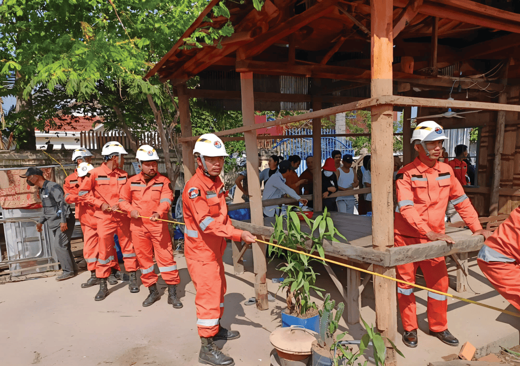

The National Committee for Disaster Management (NCDM), the United Nations in Cambodia and the lead agencies of the Early Warnings for All (EW4ALL) initiative – International Federation of Red Cross and Red Crescent Societies (IFRC), International Telecommunication Union (ITU), United Nations Office for Disaster Risk Reduction (UNDRR), and World Meteorological Organization (WMO), have organized the National Consultation Workshop on Early Warnings for All to bring key stakeholders together to strategize and enhance Cambodia’s early warning system, a vital component in minimizing the impact of disasters and adapting to climate change.
“As a nation, Cambodia is actively working to strengthen its disaster preparedness and early warning systems, with the aim of safeguarding lives, empowering communities, and fostering a resilient future for all Cambodians,” stated Sameun Hang, Second Vice of NCDM, emphasizing that the workshop marks a significant milestone in the country’s journey towards implementing comprehensive disaster risk reduction and climate adaptation measures.
However, significant global, regional, and national gaps persist in translating early warnings into effective actions such as efforts are still required to enhance awareness, build adequate institutional capacity, connectivity challenges, strengthen community engagement, enhance preparedness planning, create sufficient funding, including for operationalization and maintenance of hydro-met stations, and creating adequacy of hydrological and meteorological observations covering the whole country.
“Cambodia is prone to various climate-induced hazards, such as floods, drought or storms. These hazards pose significant risks to communities, agriculture, infrastructure and the economy. Early warning systems are proven to be an effective tool that mitigates the impact of climate-induced disasters and, develops a more resilient nation,” said Jo Scheuer, UN Resident Coordinator in Cambodia.
Government ministries, UN agencies, bilateral and multilateral organizations, international non-governmental organizations, civil society organizations, regional bodies, private sector entities and technical experts participated in the workshop. They reviewed the current state of early warning systems in Cambodia, assessing progress in implementing the four pillars of EW4ALL: disaster risk knowledge; observations and forecasting; dissemination and communication; and preparedness and response. They also discussed financing instruments and investment needs, as well as identified priority technical areas for advancing early warning systems in the country. One outcome was to establish a national coordination mechanism for EW4ALL, leveraging existing disaster management structures in Cambodia and fostering collaboration and coordination among stakeholders to drive effective implementation of early warning systems nationwide.
“The insights gained from these discussions will shape the country’s EW4ALL implementation roadmap for 2024-2027,” stated Claire Conan, WFP-Cambodia country director. She emphasized WFP’s role as the UN focal point in Cambodia for the EW4ALL initiative and its support to the global leads in crafting a comprehensive roadmap to further early warnings in Cambodia. “Through strategic partnerships and collaboration with national and global leaders in disaster risk reduction, WFP is committed to contribute to timely and effective early warnings for every Cambodian. Together, we’re building resilience and shaping a safer future.
The United Nations World Food Programme is the world’s largest humanitarian organization, saving lives in emergencies and using food assistance to build a pathway to peace, stability and prosperity for people recovering from conflict, disasters and the impact of climate change.
For more information please contact (email address: chanmoniroth.iv@wfp.org):
Chanmoniroth IV, WFP/Cambodia, Mob. +85586 315 888
Recent Major Disasters
The susceptibility of Cambodia to natural disasters, including floods, droughts, and storms, can be attributed to its unique historical context as a nation recovering from a period of civil conflict. Furthermore, with a predominantly agrarian economy, it presents challenges and vulnerabilities regarding natural disasters.
Cambodia faces challenges related to its capacity, infrastructure, and institutional constraints, which, when compounded, heighten its vulnerability to climate variability and change. In this context, it is important to note that storms also pose a significant threat to Cambodia, adding to the complexity of its disaster risk landscape. Over the past decade, Cambodia has grappled with recurrent natural disasters, including droughts, floods, and storms.
(Source: Climate Change Knowledge Portal, World Bank)
Floods (2022)
Severe flooding from May 2022 resulted in significant damage. From September 1st to October 11th, approximately 85,482 households in 14 provinces were affected, leading to evacuations, casualties, and damage to houses, infrastructure, and agricultural land. The risk of severe floods persisted until the end of October.


Flood (September-October 2011)
TOP PAGE > Information on Disaster Risk Reduction of the Member Countries Information on Disaster Risk Reduction of the Member Countries CambodiaCambodia General Information CambodiaFormal Name: Kingdom of Cambodia Geographical Location: Cambodia is located in Southeast Asia, bordered by Vietnam to the east, Thailand to the west, and Lao PDR to the north. To the south, it is bounded by the Gulf of Thailand. Land Area: Covering approximately 181,035 square kilometers, Cambodia boasts diverse geography, including the Mekong River, which traverses 500 kilometers of its territory, and the iconic Tonle Sap Lake in the mid-western region. Population: According to the latest data from WorldOmeter, Cambodia is home to nearly 17 million people, making it one of the most populous countries in Southeast Asia. The population is predominantly composed of Khmer (90%) and various ethnic minorities, including Cham, Chinese, Vietnamese, and indigenous mountainous tribes. Administrative Divisions: The nation is divided into 24 provinces, with its capital city being Phnom Penh, serving as the political, socio-economic, and cultural hub. Climate: Cambodia experiences a tropical climate dominated by the monsoon. Notably, the monsoon season, which typically occurs from May to October, plays a pivotal role in its climate patterns. During the monsoon season, Cambodia receives a substantial portion of its annual rainfall, accounting for almost 75% of its total precipitation. The dry season, spanning from November to April, offers a respite from heavy rainfall, creating favorable conditions for various outdoor activities and agricultural activities. Overview of Disasters Susceptibility of Cambodia to natural disasters, including floods, droughts, and storms, can be attributed to its unique historical context as a nation recovering from a period of civil conflict. Furthermore, with a predominantly agrarian economy, it presents challenges and vulnerabilities regarding natural disasters. Cambodia faces challenges related to its capacity, infrastructure, and institutional constraints, which, when compounded, heighten its vulnerability to climate variability and change. In this context, it is important to note that storms also pose a significant threat to Cambodia, adding to the complexity of its disaster risk landscape. Over the past decade, Cambodia has grappled with recurrent natural disasters, including droughts, floods, and storms. (Source: Climate Change Knowledge Portal, World Bank) Recent Major Disasters Flood (September-October 2011) In 2011, flood affected 350,000 households (over 1.5 million people) and 52,000 households were evacuated. 18 out of 24 provinces in Cambodia were affected; 4 provinces along Mekong River and Tonle Sap were worst hit; 250 people died and 23 people were injured as result of the flood. 431,000 hectares of transplanted rice fields were affected and 267,000 hectares of rice fields were damaged. 925 kilometers of the national, provincial and urban roads were affected and 360 kilometers of the roads were damaged. The floods in 2011 caused an estimated loss at 630 million USD.
Drought (2011-12)
In 2011, drought affected 3,804 hectares of rice fields. Furthermore, in 2012, drought affected 14,190 hectare of rice fields and completely destroyed crops of 3,151 hectares.
Disaster Management System
Legal System
Cambodia has enacted a comprehensive Law on Disaster Management in 2015, providing a robust legal framework for disaster preparedness, response, and recovery.
Law on Disaster Management (Source: IFRC, English version)
Organization
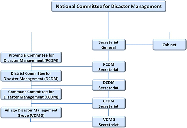
The National Committee for Disaster Management (NCDM), headed by the Prime Minister, serves as the central coordinating body. The NCDM Secretariat leads and coordinates disaster management efforts at the national level. Disaster management is decentralized through Provincial Committees for Disaster Management (PCDM), District Committees for Disaster Management (DCDM), and Commune Committees for Disaster Management (CCDM). Village Disaster Management Groups (VDMG) operate at the grassroots level, actively participating in local disaster management activities.
Plan
Disaster management system of Cambodia underscores its commitment to enhancing disaster preparedness, response, and mitigation measures. Effective coordination among government agencies, humanitarian entities, and development partners is integral to its disaster prevention efforts. There are the following DRM related plans in Cambodia.
– National Strategy Development Plan (NSDP) 2009-2013
– Strategic National Action Plan for Disaster Risk Reduction (SNAP) 2008-2013
– National Action Plan for Disaster Risk Reduction 2014-2018 (drafted & adopted by 2014)
– National Comprehensive Avian and Human Influenza Plan (Multi-Sectoral Pandemic Preparedness and Response Plan)
– Community Based Disaster Risk Management Plan (CBDRM)
– National Contingency Plan for Flood and Drought (being revised)
ADRC Counterpart
National Committee for Disaster Management (NCDM)
National Met Agency Cambodia

Cambodia is located in Southeast Asia, bordered by Vietnam to the east, Thailand to the west, and Lao PDR to the north. To the south, it is bounded by the Gulf of Thailand. Land Area: Covering approximately 181,035 square kilometers, Cambodia boasts diverse geography, including the Mekong River, which traverses 500 kilometers of its territory, and the iconic Tonle Sap Lake in the mid-western region. Population: According to the latest data from WorldOmeter, Cambodia is home to nearly 17 million people, making it one of the most populous countries in Southeast Asia. The population is predominantly composed of Khmer (90%) and various ethnic minorities, including Cham, Chinese, Vietnamese, and indigenous mountainous tribes. Administrative Divisions: The nation is divided into 24 provinces, with its capital city being Phnom Penh, serving as the political, socio-economic, and cultural hub. Climate: Cambodia experiences a tropical climate dominated by the monsoon. Notably, the monsoon season, which typically occurs from May to October, plays a pivotal role in its climate patterns. During the monsoon season, Cambodia receives a substantial portion of its annual rainfall, accounting for almost 75% of its total precipitation. The dry season, spanning from November to April, offers a respite from heavy rainfall, creating favorable conditions for various outdoor activities and agricultural activities. Overview of Disasters Susceptibility of Cambodia to natural disasters, including floods, droughts, and storms, can be attributed to its unique historical context as a nation recovering from a period of civil conflict. Furthermore, with a predominantly agrarian economy, it presents challenges and vulnerabilities regarding natural disasters. Cambodia faces challenges related to its capacity, infrastructure, and institutional constraints, which, when compounded, heighten its vulnerability to climate variability and change. In this context, it is important to note that storms also pose a significant threat to Cambodia, adding to the complexity of its disaster risk landscape. Over the past decade, Cambodia has grappled with recurrent natural disasters, including droughts, floods, and storms. (Source: Climate Change Knowledge Portal, World Bank) Recent Major Disasters Flood (September-October 2011) In 2011, flood affected 350,000 households (over 1.5 million people) and 52,000 households were evacuated. 18 out of 24 provinces in Cambodia were affected; 4 provinces along Mekong River and Tonle Sap were worst hit; 250 people died and 23 people were injured as result of the flood. 431,000 hectares of transplanted rice fields were affected and 267,000 hectares of rice fields were damaged. 925 kilometers of the national, provincial and urban roads were affected and 360 kilometers of the roads were damaged. The floods in 2011 caused an estimated loss at 630 million USD.
Drought (2011-12)
In 2011, drought affected 3,804 hectares of rice fields. Furthermore, in 2012, drought affected 14,190 hectare of rice fields and completely destroyed crops of 3,151 hectares.
Disaster Management System
Legal System
Cambodia has enacted a comprehensive Law on Disaster Management in 2015, providing a robust legal framework for disaster preparedness, response, and recovery.
Law on Disaster Management (Source: IFRC, English version)
Organization
The National Committee for Disaster Management (NCDM), headed by the Prime Minister, serves as the central coordinating body. The NCDM Secretariat leads and coordinates disaster management efforts at the national level. Disaster management is decentralized through Provincial Committees for Disaster Management (PCDM), District Committees for Disaster Management (DCDM), and Commune Committees for Disaster Management (CCDM). Village Disaster Management Groups (VDMG) operate at the grassroots level, actively participating in local disaster management activities.
Plan
Disaster management system of Cambodia underscores its commitment to enhancing disaster preparedness, response, and mitigation measures. Effective coordination among government agencies, humanitarian entities, and development partners is integral to its disaster prevention efforts. There are the following DRM related plans in Cambodia.
– National Strategy Development Plan (NSDP) 2009-2013
– Strategic National Action Plan for Disaster Risk Reduction (SNAP) 2008-2013
– National Action Plan for Disaster Risk Reduction 2014-2018 (drafted & adopted by 2014)
– National Comprehensive Avian and Human Influenza Plan (Multi-Sectoral Pandemic Preparedness and Response Plan)
– Community Based Disaster Risk Management Plan (CBDRM)
– National Contingency Plan for Flood and Drought (being revised)
ADRC Counterpart
National Committee for Disaster Management (NCDM)
Country Report
Cambodia Disaster Loss and Damage Analysis Report (1996-2013) (English Version, PDF file)
Country Report 2013 (English Version, PDF file)
Country Report 2006 (Japanese Version, PDF file)
Country Report 2006 (English Version, PDF file)
Country Report 2003 (English Version, PDF file)
Country Report 2002 (English Version, PDF file)
Country Report 1999 (English Version, PDF file)
Country Report 1999 (Japanese Version, PDF file)
Country Report 1998 (English Version, PDF file)
Disaster Information (The latest 10)
・2017/07/25 : Tropical Depression
Susceptibility of Cambodia to natural disasters, including floods, droughts, and storms, can be attributed to its unique historical context as a nation recovering from a period of civil conflict. Furthermore, with a predominantly agrarian economy, it presents challenges and vulnerabilities regarding natural disasters.
Cambodia faces challenges related to its capacity, infrastructure, and institutional constraints, which, when compounded, heighten its vulnerability to climate variability and change. In this context, it is important to note that storms also pose a significant threat to Cambodia, adding to the complexity of its disaster risk landscape. Over the past decade, Cambodia has grappled with recurrent natural disasters, including droughts, floods, and storms.
(Source: Climate Change Knowledge Portal, World Bank)
The National Council for Sustainable Development

NCDM – National Committee for Disaster Management
https://climateknowledgeportal.worldbank.org/country/cambodia
Some useful documents on Cambodia
Subject: Looking forward to the scope of work and partnership opportunity with NCDM , Cambodia
To,
H.E. Mr. MA Norith
Dear Sir,
Greetings from the Multi-Hazard Early Warning System Design and Implementation Center (MHEWC).
MHEWC provides technical solutions to strengthen Disaster Risk Management (DRM) governance systems, climate and multi-hazard risk management, and end-to-end early warning system design and implementation. We would be pleased to offer technical support to the NCDM – National Committee for Disaster Management, Cambodia, in the following areas:
a) Upgrading NCDM ’s existing web portal into a geospatial, database-driven, and app-enabled Decision Support System (DSS) to support real-time disaster risk governance, planning, preparedness, response, and recovery management.
b) Conducting climate and multi-hazard risk and vulnerability assessments, including the preparation of geospatial hazard, exposure, vulnerability, and risk maps, and the establishment of a centralized risk information repository and database management system.
c) Assessing existing monitoring, observation, and early warning capacities and supporting NCDM in the installation, enhancement, and integration of observation networks, including Automated Weather Stations (AWS), hybrid weather and hazard monitoring systems, and sensor-ingested real-time data systems linked to a functional DSS.
d) Designing and operationalizing end-to-end multi-hazard early warning systems, including weather and hazard nowcasting services, impact-based forecasting, forecast-based anticipatory early action, forecast-based emergency preparedness and response management, forecast-based financing, Early Action Protocol development, and DSS-supported Standing Orders on Disaster and Standard Operating Procedures.
e) Supporting automated hazard detection, monitoring, prediction, and emergency operations management, including the design, implementation, and operationalization of a Multi-Hazard and Disaster Emergency Operations Center (EOC).
f) Developing GIS, database, and information tool-driven local government and productive sector-level risk-informed planning and budgeting systems to strengthen disaster risk reduction, climate change adaptation, nature-based solutions, locally led adaptation, and resilience planning.
g) Reviewing and upgrading multi-hazard preparedness, response, and recovery plans across administrative levels and relevant priority sectors, in alignment with NCDM’s institutional mandate and national disaster management priorities.
h) Providing any additional technical assistance as may be required by NCDM to strengthen national-to-last-mile disaster risk governance and early warning capacities.
We would welcome the opportunity to discuss NCDM’s priorities and explore how MHEWC can support the development of a practical implementation roadmap for strengthening multi-hazard early warning, risk information, and disaster risk governance systems in the Cambodia.
We look forward to your kind response.
Sincerely,
Z M Sajjadul Islam
Advisor & Director
Multi-Hazard Early Warning System Design and Implementation Center (MHEWC)
Web: www.mhewc.org https://www.mhewc.org/cambodia
Email: zmsajjad@gmail.com sajjad@mhewc.org
Phone & WhatsApp: +88 01711 979179