Roadmap for Implementation of Early Warning for All (EW4ALL) Initiative 2024-2027/2030 for Somalia
Developed by Z M Sajjadul Islam, UNDRR – Early Warning for All (EW4ALL) Coordinator for Somalia
Building Disaster Resilient Somalia
Executive Summary
Early Warnings for All (EW4ALL) a global initiative to ensure that everyone on Earth is protected by early warnings by 2027 is being fast-tracked into action on the ground. The UN Secretary-General released an action plan for this initiative in November 2022, emphasizing the urgent need to support the most vulnerable first.
The Office of the United Nations Disaster Risk Reduction (UNDRR) supported the Somalia Disaster Management Agency (SoDMA) /National Disaster Management Organization(NDMO) in facilitating the design and drafting of a Roadmap for implementing the Early Warning for All (EW4ALL) Initiative in Somalia.
While governments play a crucial role in driving action on early warning services for their citizens, adopting a “whole-of-society” approach that involves all stakeholders, including civil society and the private sector, can better strengthen and sustain early warning services.
It’s equally important to recognize that disasters and climate change affect people differently based on gender, age, and other factors. Therefore, an intersectional approach is required to ensure that the early warning services are inclusive, responsive, and equitable. By involving all sectors of society and taking an intersectional approach, early warning services can be more effective in protecting vulnerable populations from the impacts of disasters and climate change.
As these events become increasingly frequent and intense, efforts to build resilience and coping capacities are crucial. Climate change is also a major driver of conflict in Somalia, for example, as declining groundwater levels drive up water prices and increase the likelihood of conflict over water and access to livelihoods. Multi-hazard early warning systems (MHEWS) linked to early actions are key to Somalia’s efforts to manage risks, enhance adaptation, and build resilience.
The National Multi-Hazard Early Warning Centre (NMHEWC) was established to provide adequate and timely warnings of possible risks posed by hazards. However, the country lacks a robust early warning system infrastructure that enables policy and institutional environments for the dissemination of warnings.
In this context, the SoDMA/NDMO calls for the national Rollout of the Early Warnings for All (EW4All) initiative, finalizing the gap analysis, and agreeing on a roadmap to consolidate and extend the coverage of MHEWS, empowering and enabling early action by individuals and communities, especially those most in need.
1.0 Introduction: EW4ALL
Somalia needs to implement risk-informed tools for climate-proof planning and support disaster risk management governance with thematic forecasts, weather warnings, and public alerting to prepare the country for, respond to, and recover from extreme weather events.
Somalia is already experiencing significant losses and damage from human-induced climate change. The direct economic impacts of extreme climate events, such as droughts and floods, affect vital sectors like agriculture and livestock. Agriculture, including the livestock sector, is Somalia’s largest employer and second-largest commodity export. Nearly one-fourth of the population is agropastoralists, with smallholder farming making up approximately.
80% of total crop production and 70% of the marketed produce. Over 60% of the Somali population depends on livestock, contributing 40% to the country’s GDP[1]. Hydrometeorological hazards are recurrently impacting those productive sectors.
Losses and damages can result from extreme weather and climate events that occur relatively quickly, such as floods, tropical storms, heat waves, and protracted droughts. Direct economic loss and damage to the agriculture sector in Somalia are estimated to have totaled $5.68[2] Billion, of which about half, $2.84 billion, representing 5% of agriculture GDP on average between 2000 and 2021, could be attributable to climate change. Climate-attributable livestock and crop loss and damage of (on average) $129 million are already incurred yearly in Somalia.
From 2008 to 2011, droughts in the Horn of Africa triggered a cycle of heightened and persistent food insecurity. In combination with other factors – including conflict, low incomes, escalating global commodity prices, marginalization of certain ethnic groups, and insecurity limiting humanitarian access – the droughts are estimated to have plunged 17% of the population of southern and central Somalia into famine conditions (Majid and McDowell, 2012; Maxwell and Fitzpatrick, 2012). The cascading impacts of the droughts exacerbated poverty and other elements of vulnerability in the country.
On average, Somalia’s direct economic impacts from droughts and floods amounted to 7.9% of the country’s GDP between 2000 and 2021, excluding the 2010 drought events.[3]. About half (3.3% of GDP) of these total losses and damages could be attributable to climate change. Including the 2010/2011 drought, which led to economic damages of over $4 billion, this proportion of attributable loss and damage rises to 8.4% of GDP. Furthermore, between 2000 and 2021, on average, these attributable direct economic losses and damages equaled 86% of government revenues, excluding the 2010 drought event (over 200% of government revenues, including the 2010 drought event).
Somalia intended the EW4ALL system to be the center of excellence for instrumentalizing sustainable development and providing technocratic policymakers with sufficient, evidence-based tools for risk-informed planning, budgeting, and project implementation processes. Most importantly, EW4ALL would enhance the country’s risk finance policy and advocacy, empowering access to the global risk finance domains.
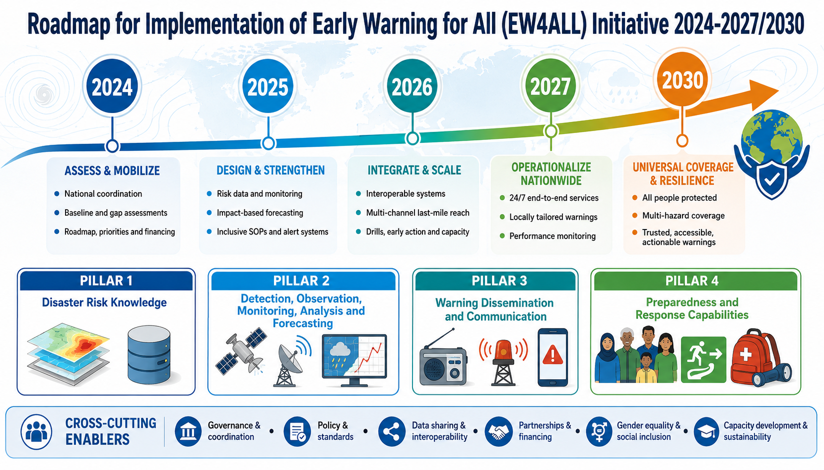
The EW4ALL roadmap (2024-2027/2030) outlines the pathway for the effective implementation of the EW4ALL pillars over the period of 2024-2027 and beyond. The intended structure and process would enable the evolution of a Multi-hazard Early Warning System (MHEWS), including hazard forecasts and warning dissemination, to provide holistic support for Disaster Risk Management (DRM), Disaster Risk Reduction (DRR) & Climate Change Adaptation (CCA) interventions. Therefore, developing an enabling environment by establishing a simple and well-understood law or policy, or an institutional framework, along with forecasting services, is necessary. It is recommended that clear responsibilities be established to create a smoother workflow from start to finish. EWS are proven, efficient, and cost-effective DRR and CCA measures that save lives and provide a tenfold return on investment. Yet, major gaps in early warning systems remain global, especially when translating early warnings into risk-informed early action.
[1] Government of Somalia, 2018
[2] & 3 Pastoralism and Agriculture in Recurrent and Protracted Crisis (SPARC) programme, September 2024
1.1 Vision EW4ALL
The National EW4ALL roadmap envisions that by 2027, all Somali people will be protected by a robust, government-led multi-hazard early warning system.
1.2 Principles EW4ALL
The following principles underpin Somalia’s Roadmap for EW4ALL Implementation and reflect the spirit of disaster risk governance for Somalia. The core principles serve as the basis of the EW4ALL Initiative and guide the implementation of critical functions of the country’s National Multi-Hazard Early Warning System (NMHEWS).
Accountability – All government and non-governmental parties should be held accountable for the early warning information and predictions they produce.
Credibility Early warning information and analysis must come from credible sources and earn the trust and confidence of their users.
Do no harm All parties shall endeavor not to cause damage or suffering due to their actions regarding DRM/early warning.
Ethical – DRM/early warning operations and decision-making shall always be guided by ethics and values that accept and respect the primacy of human life and human dignity.
Impartiality – Early warning information, analysis, and decisions should be based on objective data without bias, prejudice, discrimination, or a preference to benefit one group or community.
Leaving no one behind – EWS shall address the concerns, needs, and inclusion of the most vulnerable social groups, including women, youth, children, people with disability, and the elderly.
Neutrality Early warning information, analysis, and decisions do not take sides and shall be conducted regardless of the political, faith, identities, or social background of the people or communities under the coverage of EWS.
People-centered and community-oriented EWS should seek to preserve and include local and ‘traditional’ perspectives and Indigenous knowledge to strengthen community ownership. It should be developed in collaboration with the end-users, and the disaster-affected people shall communicate and understand its impacts. It needs to be more people-oriented with a focus on last-mile outreach.
Transparency EWS should be transparent, allowing public access to early warning data and knowledge products. Both at federal and regional levels, EWS should be located within government structures and operate within a clear legal framework, with the spirit of accessing the information as a credible source for public benefit.
1.2 Goals and Objectives EW4ALL
Early Warnings for All is built on four pillars that are the cornerstones of the initiative and of effective multi-hazard early warning. The purpose of this Roadmap is to identify the current gaps in the four pillars of EW4ALL and suggest ways to overcome these gaps; more specifically, the roadmap aims to:
- Improve Disaster risk knowledge and management (led by UNDRR) : Enhance risk knowledge of institutions, stakeholders, and the frontline community. Enhance institutional risk assessment capacity, risk repository development, risk data, and tools to generate impact-based early warning products and information services.
- Improve Detection, observation, monitoring, analysis, and forecasting (led by WMO) : Somali access to improved weather observation data for forecasting, access to global & regional forecasting products from GPCs, RSMCs, and HMHS. Formulation of national hydrometeorological plans, strategies, and legislation in hydromet observation and acquisition of Essential climate variables (ECV) , data calibration, collation, and data attribution for meteorological forecasting. Enhance the National Multi-hazard Early Warning Center ( NMHEWC) in innovative forecasting, nowcasting, and prediction capability.
- Improve Warning dissemination and communication (led by ITU) : Enhance national institutional, stakeholders, and frontline capacity in the risk communication value chain, translating forecasts into localized early warning, common alerting, weather warning, and NMHS, SoDMA , local stakeholders’, and community capacity in the people-centered warning system.
- Better Preparedness and response capabilities (led by IFRC/FAO/SRCS): Enhance the capacity of SoDMA, Local government, local nonstate actors/stakeholders, and community capacity in disaster preparedness and response capacity. Improve instructional capacity in Disaster Risk Management (DRM), Disaster Risk Reduction (DRR), and resilience-building capacity.
Figure 1: Early Warning for All (EW4ALL) objective
1.4 Rationale of National Multi-hazard Early Warning Center (NMHEWC) installation
The National Multi-hazard Early Warning Center (NMHEWC) was established in 2019 following an executive order by the Office of the Prime Minister (OPM) and is led by a joint inter-ministerial Committee of the OPM and MoHADM. The main purpose of NMHEWC is to coordinate and lead significant Emergency Responses and provide a coordinated, timely, and efficient response in case of future disasters and emergencies. The NMHEWC aims to enhance the institutional capacity of all governments for holistic disaster risk management.
SoDMA/NDMO is entrusted with executing the operational modality of NMHEWC and is governed by the honorable Prime Minister. Having NMHEWC under the auspices of the Office of the Prime Minister is expected to enhance its leadership among all government ministries and agencies involved in DRM in the country, as well as with FMS, UN Agencies, and development partners.
The NMHEWC has central roles and responsibilities in synchronizing and synergizing all state institutions that run ad-hoc emergency responses and non-state DRM and humanitarian actions currently undertaken by UN Agencies, INGOs, and CSOs nationwide. The SoDMA/NDMO plays a pivotal role in networking key representatives from federal and member state level institutions, donor communities, UN agencies, INGOs, NGOs, private sector multinationals, and financial institutions, establishing a model for effective emergency management.
1.5 SoDMA/NDMO EW4ALL initiative
On October 15, 2023, H.E., the President of the Federal Republic of Somalia, nominated the Somalia Disaster Management Agency (SoDMA) as the right national focal institution to lead the EW4All initiative at the national level.
In collaboration with the UNDP Somalia country office, the EW4ALL initiative is now operationalized under the leadership of SoDMA. The National Multi-Hazard Early Warning Center (NMHEWC) is already operational under SoDMA, positioning the institution as the most effective way to continue coordinating the scaling-up of the EW4All Initiative into action at the national level.
On November 15 – 16, 2023, SoDMA held a national consultation to launch Early Warnings for All (EW4All) in partnership with the United Nations Resident Coordinator Office (UNRCO) and the United Nations Country Team (UNCT) and in technical cooperation with UNDRR, World Meteorological Office (WMO), and International Telecommunication Union (ITU) as global co-leads for the Secretary-General’s EW4All initiative.
Affirming Somalia’s commitment to the objectives and spirit of EW4All, national government stakeholders, in partnership with UN country teams led by UNDP, came forward to articulate priorities and gaps to be addressed across the four EWS pillars.
On June 9–10, 2024, a workshop was held in Mogadishu to finalize the gap analysis and develop a national roadmap for implementing the Early Warning for All (EW4ALL) Initiative in Somalia, marking the rollout of the initiative.
The Roadmap for Early Warning for All (EW4ALL) builds on the country’s existing National Multi-Hazard Early Warning System (NMHEWS) and is concurrent with Somalia’s commitment to the Sendai Framework for Disaster Risk Reduction (2015–2030).
Critically, the Roadmap development process has been accompanied by a systematic reform initiative to align it with Article 3, paragraph 6, and Article 7, paragraph 2, of Law 17/2016, which establishes the Somali Disaster Management Agency (SoDMA). These Articles state the clear responsibility of SODMA to gather information and report on disasters and the risks facing the country, and to send out early warnings in collaboration with organizations inside and outside the country working on these activities. This is a positive step towards elevating the portfolio of SODMA, strengthening the Agency’s role by creating a functioning National Multi-Hazard Early Warning System. It will also provide the agency with an extended mandate to effectively coordinate DRM endeavors with multiple stakeholders, including regional and Federal Member State (FMS) government bodies, representatives of civil society organizations, and National Red Crescent Societies. The arrangement of this Roadmap also expects to promote local community participation and raise public awareness about disaster risk reduction and management. It is hoped that this Roadmap will foster the development of robust collaborations among key early warning stakeholders and establish a coordination mechanism that brings together the EW4ALL Pillar leads and relevant stakeholders.
The roadmap is also expected to facilitate the implementation of the EW4ALL Initiative in Somalia and enhance coordination, accountability, and enforcement of inter-jurisdictional and regional early warning systems and initiatives.
The critical undertaking here is for the Government of Somalia to develop a national EW4All Roadmap 2024-2027, with support from the UN agencies and global EW4All Pillar leads.
Contents
1.2 Goals and Objectives EW4ALL. 8
1.4 Rationale of National Multi-hazard Early Warning Center (NMHEWC) installation. 9
1.5 SoDMA EW4ALL initiative. 9
2.0 Somalian multi-hazard, disaster phenomena & climate change trend. 11
2.1 Somalian current climate projection: 14
2.2 Climate trends, impacts, and Stressors. 14
3.0 Pillar Specific Goal, Outcome, and Workplan. 16
3.1.1 Pillar 1 Gap Identification on Disaster Risk Knowledge. 16
3.1.2 Step forward to close the gap of Pillar 1 Disaster Risk Knowledge. 18
3.1.3 Proposed key actions for closing the indicated gaps : Disaster Risk Knowledge. 18
3.1.4 The Roadmap ahead for Pillar 1: Improved Disaster Risk Knowledge management System.. 23
3.1.5 Work Plan for Pillar 1. 29
3.2 Roadmap Pillar 2: Observation, monitoring, analysis, and forecasting, 31
3.2.1 Pillar 2 Gap Identification: Observation, monitoring, analysis, and forecasting. 32
3.2.3 Proposed Roadmap for Pillar 2 : Observation, monitoring, analysis, and forecasting. 39
3.2.4 Work Plan for Pillar 2 : Observation, monitoring, analysis, and forecasting. 44
3.3 Roadmap Pillar 3: Warning dissemination and communication. 48
3.3.1 Pillar 3 Indicative gaps : Warning dissemination and communication. 49
3.3.2 Proposed key action for closing Pillar 3 gaps. 49
3.3.3 The roadmap for Pillar 3 : Enhancing effective dissemination and communication. 55
3.3.4 Workplan Pillar 3 : Warning dissemination and communication. 59
3.4 Roadmap Pillar 4: Preparedness and response capabilities. 63
3.4.1 Indicative Gaps on Pillar 4 -Preparedness and response capabilities. 63
3.4.2 Roadmap outlined actions for closing the Gaps on Pillar 4 by 2027 and beyond. 65
3.4.3 Roadmap ahead for Pillar 4 by 2027 and beyond. 68
3.4.4 Work Plan for Pillar 4 (Preparedness, timely responses and early actions) 71
4.0 Monitoring & Evaluation Plan of EW4ALL Pillars. 75
Download EW4ALL Roadmap (PDF format)
Download EW4ALL Roadmap (Word Document format)
Designing & Implementation of Multi-Hazard Early Warning System(MHEWS) https://www.mhewc.org/designing-implementation-of-mhews/
Detailed Climate, Multi-Hazard and Disaster-Risk and Vulnerability Profile of Somalia

Climate risk and vulnerabilities of Somalia
Somalia is highly vulnerable to climate change and multi-hazard risks due to its arid and semi-arid climate, recurrent droughts, seasonal floods, long coastline, fragile water systems, dependence on pastoralism and rainfed agriculture, widespread food insecurity, conflict-related displacement, poverty, and limited institutional and infrastructure capacity. The country faces recurrent risks from droughts, flash floods, riverine floods, coastal flooding, cyclones and storms, extreme heat, water scarcity, land degradation, desertification, desert locust and pest outbreaks, livestock losses, crop failure, and climate-sensitive disease risks. Somalia’s National Adaptation Plan identifies droughts and erratic rainfall as major climate threats, with recent decades marked by repeated droughts, floods, and increasingly severe climate shocks. (UNFCCC).
Somalia is highly exposed and vulnerable to climate change and multi-hazard risks due to its arid and semi-arid climate, recurrent droughts and floods, fragile water resources, degraded rangelands, dependence on pastoralism and rainfed agriculture, conflict, displacement, poverty, and limited institutional and infrastructure capacity. The country faces major risks from droughts, flash floods, riverine floods, extreme heat, water scarcity, land degradation, desertification, coastal flooding, livestock losses, crop failure, food insecurity, and climate-sensitive disease outbreaks. Climate change is expected to intensify these vulnerabilities through rising temperatures, erratic rainfall, more frequent droughts, heavier seasonal rainfall in some areas, flash flooding, reduced livelihood security, and increasing pressure on food systems, water resources, health, infrastructure, and vulnerable communities. Strengthening multi-hazard early warning systems, impact-based forecasting, drought and flood risk management, water security, climate-resilient pastoralism, rangeland restoration, shock-responsive social protection, disaster risk financing, and conflict-sensitive locally led adaptation is essential to reduce losses and protect Somalia’s vulnerable populations.
Multi-hazard exposure
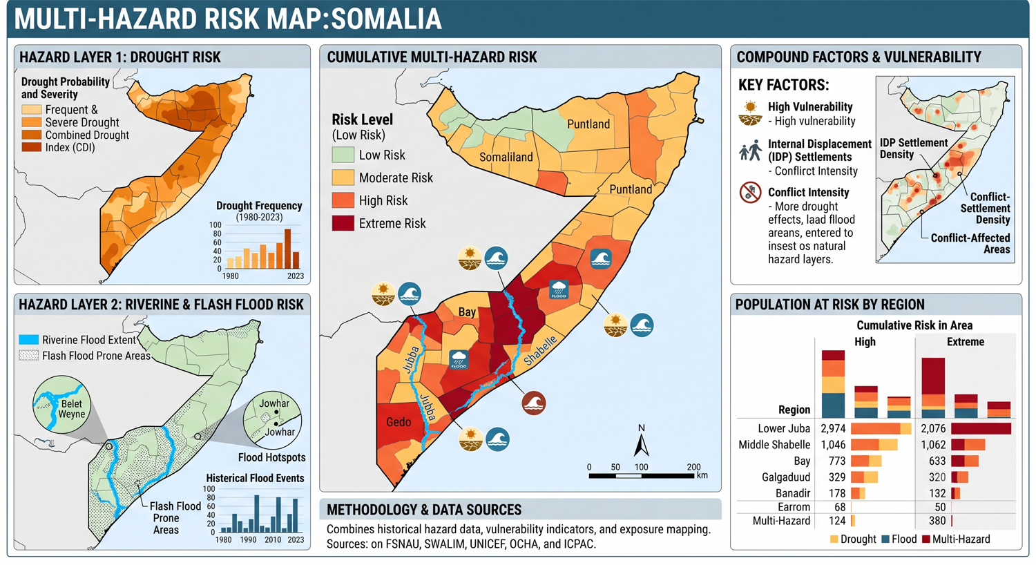
Somalia’s disaster-risk profile is dominated by drought and floods, but these hazards are increasingly compound and cascading. El Niño conditions can bring heavy rainfall and flooding, while La Niña conditions are associated with reduced rainfall and drought. This means Somalia can experience alternating or even overlapping extremes: prolonged drought weakening households, livestock, water points, and markets, followed by intense rainfall that causes flash floods, river flooding, displacement, disease outbreaks, and infrastructure damage. (Weathering Risk)
The main hazard types include:
|
Hazard |
Main risk pathways |
|---|---|
|
Drought |
Water scarcity, pasture loss, livestock mortality, crop failure, food insecurity, displacement |
|
Flash floods |
Rapid runoff, damaged settlements, roads, water points, WASH facilities, and markets |
|
Riverine floods |
Flooding along the Juba and Shabelle river basins, crop loss, displacement, disease risks |
|
Extreme heat |
Livestock stress, human health risks, water demand, reduced labour productivity |
|
Coastal hazards |
Coastal flooding, erosion, storm impacts, saline intrusion, damage to ports and fishing livelihoods |
|
Land degradation |
Rangeland decline, soil erosion, desertification, reduced natural-resource productivity |
|
Pests and disease outbreaks |
Desert locust risk, livestock disease, vector- and water-borne disease after floods |
Climate change as a fragility multiplier
Climate change in Somalia is not only an environmental issue; it is a fragility, food-security, displacement, livelihood, and governance risk multiplier. UNDRR notes that Somalia has faced compounding impacts from droughts, floods, and conflict, where disaster impacts deepen poverty, drive displacement, and fuel instability. Somalia is therefore advancing the Early Warnings for All agenda to strengthen disaster preparedness and reduce cascading risks. (UNDRR)
The Red Cross Red Crescent Climate Centre reports that higher rainfall and runoff are expected during the Deyr season across several climate scenarios, increasing the threat of flash flooding, while drought and heat remain major humanitarian risks. (Climate Centre)
Drought, water scarcity, and pastoralist vulnerability
Drought is Somalia’s most severe recurrent climate risk. It directly affects water availability, pasture, livestock health, household income, food prices, nutrition, and migration. Pastoralist and agro-pastoralist communities are especially vulnerable because their livelihoods depend on seasonal rainfall, grazing lands, water points, livestock mobility, animal health, and access to markets.
Repeated droughts reduce herd sizes, weaken livestock, increase debt, erode household assets, and reduce milk and meat production. For poor pastoralist households, livestock loss is not only an income shock; it can destroy the household’s entire recovery base. Drought also places pressure on women and children through longer water-collection distances, reduced food availability, school disruption, and higher protection risks.
Flood, riverine, and flash-flood vulnerability
Flooding is also a major hazard, especially along the Juba and Shabelle river basins, in low-lying settlements, and in areas with weak drainage and limited flood protection. Floods damage crops, livestock, houses, roads, bridges, schools, health posts, water systems, markets, and displacement sites. They also increase risks of diarrhoeal disease, cholera, malaria, contaminated water, and shelter-related protection concerns.
Flood impacts can be especially severe after drought because soils may be degraded, vegetation cover reduced, households weakened, and coping capacity exhausted. The World Bank’s Somalia climate-risk review highlights that floods can occur even during broader drought periods, compounding the impacts of both hazards. (World Bank)
Food security, agriculture, and livestock vulnerability
Somalia’s food system is highly climate-sensitive. Livestock, rainfed crops, irrigated riverine agriculture, fisheries, and informal trade are all exposed to climate shocks. Recurrent drought, floods, market disruption, insecurity, pest outbreaks, and reduced humanitarian assistance can rapidly translate into food insecurity and malnutrition.
Recent food-security warnings remain severe. Reuters reported in 2026 that parts of southern Somalia faced famine risk for the first time since 2022, with about 6 million people facing food insecurity and acute malnutrition levels in some districts reaching alarming levels. AP also reported that nearly 6.5 million people were projected to face severe food insecurity, with 1.84 million children under five projected to suffer acute malnutrition. (Reuters)
6. Coastal and marine vulnerability
Somalia’s long coastline along the Gulf of Aden and Indian Ocean creates exposure to coastal flooding, erosion, storm impacts, saltwater intrusion, marine ecosystem degradation, and risks to ports and fishing communities. Coastal livelihoods depend on fisheries, coastal trade, ports, small businesses, and marine ecosystems, all of which can be affected by warming seas, storm damage, coastal erosion, and weak coastal infrastructure.
Coastal towns and ports are also important for humanitarian logistics, trade, fuel, food imports, and economic recovery. Damage to coastal infrastructure can therefore create wider cascading effects beyond the coast.
Health, WASH, and displacement vulnerability
Climate shocks in Somalia are closely linked to public health risks. Drought reduces safe water availability and worsens malnutrition, while floods contaminate water sources, damage sanitation systems, and increase waterborne and vector-borne disease risks. Displacement sites are particularly vulnerable because overcrowding, poor drainage, limited WASH services, weak shelter, and food insecurity can turn climate shocks into health emergencies.
Somalia’s vulnerability is intensified by large-scale displacement. Recent reporting shows that droughts, floods, conflict, poverty, and aid cuts continue to drive displacement and humanitarian need, with millions of people affected by hunger and limited access to basic services. (The Guardian)
Sector-specific vulnerability summary
|
Sector |
Main climate and multi-hazard risks |
|---|---|
|
Pastoralism and livestock |
Drought, pasture loss, water scarcity, livestock disease, heat stress, animal mortality |
|
Agriculture and food security |
Erratic rainfall, crop failure, floods, pests, drought, market disruption, malnutrition |
|
Water resources and WASH |
Drought, groundwater stress, flood contamination, damaged water points, poor sanitation |
|
Settlements and displacement sites |
Flooding, heat stress, poor drainage, weak shelter, disease outbreaks, protection risks |
|
Health |
Malnutrition, cholera, diarrhoeal disease, malaria, heat stress, disrupted services |
|
Coastal zones and fisheries |
Coastal flooding, erosion, storm damage, marine ecosystem stress, livelihood disruption |
|
Transport and infrastructure |
Washed-out roads, damaged bridges, access constraints, disrupted humanitarian delivery |
|
Rangelands and ecosystems |
Desertification, land degradation, invasive species, reduced pasture productivity |
Social vulnerability
The most vulnerable groups include pastoralists, agro-pastoralists, smallholder farmers, internally displaced people, conflict-affected communities, women-headed households, children, older persons, people with disabilities, poor urban households, fishing communities, and communities living in drought-prone, flood-prone, riverine, coastal, or insecure areas.
Vulnerability is highest where climate exposure overlaps with poverty, conflict, weak markets, limited access to water, poor health services, low livelihood diversification, limited savings, displacement, and weak last-mile early warning.
Priority resilience needs
Somalia’s resilience agenda should prioritize multi-hazard early warning systems, impact-based forecasting, drought monitoring, flood forecasting, river-level monitoring, anticipatory action, water-security planning, climate-resilient pastoralism, climate-smart agriculture, rangeland restoration, flood-safe WASH systems, shock-responsive social protection, disaster risk financing, and conflict-sensitive locally led adaptation.
A practical resilience package for Somalia should include:
|
Priority area |
Key actions |
|---|---|
|
Early warning and anticipatory action |
Impact-based warnings for drought, floods, heat, storms, food insecurity, livestock stress, and disease outbreaks |
|
Drought and water security |
Borehole monitoring, water harvesting, groundwater protection, drought contingency planning, mobile water services |
|
Pastoralist resilience |
Rangeland management, livestock vaccination, fodder systems, livestock insurance, mobility-route protection |
|
Flood-risk management |
Juba and Shabelle flood forecasting, river embankment maintenance, floodplain mapping, evacuation planning |
|
Food-security resilience |
Climate-smart crops, seed support, agro-climate advisories, market monitoring, anticipatory cash support |
|
Health and WASH resilience |
Flood-safe water systems, cholera surveillance, nutrition response, heat-health preparedness |
|
Coastal resilience |
Coastal-risk mapping, fisheries adaptation, port resilience, saltwater-intrusion monitoring |
|
Risk governance and financing |
EW4All implementation, local disaster committees, contingency finance, forecast-based financing, scalable safety nets |
1. Executive risk overview
Somalia is one of the world’s most climate-vulnerable and disaster-affected countries. Its risk profile is shaped by an arid and semi-arid climate, highly variable rainfall, recurrent droughts, destructive river and flash floods, extreme heat, tropical cyclones, coastal hazards, land degradation, water scarcity, livestock and crop diseases, conflict, displacement, poverty, and limited infrastructure and public-service capacity.
Climate hazards do not operate separately from Somalia’s broader fragility. Drought or flooding frequently interacts with armed conflict, population displacement, market disruption, weak transport networks, disease outbreaks, environmental degradation, and insufficient humanitarian financing. Consequently, a rainfall deficit or flood that might be manageable in a more stable setting can rapidly escalate into a food-security, health, displacement, protection, and economic emergency.
The principal national risk pattern is an increasingly rapid alternation between drought and flood:
Failed or poorly distributed rainy seasons → water and pasture scarcity → livestock deaths and crop failure → food-price inflation and livelihood collapse → displacement to towns and informal settlements → extreme rainfall or river flooding → destruction of shelters, water points, latrines, roads, and remaining assets → disease outbreaks and renewed displacement.
Somalia experienced four consecutive failed rainy seasons between 2021 and 2023, producing its worst drought in approximately four decades. The crisis affected more than 7.8 million people and displaced over 1.3 million. This was followed by damaging floods during late 2023 and further flooding in 2024, illustrating the country’s exposure to abrupt transitions between rainfall deficit and excess. (World Bank)
Climate shocks now rival conflict as a major driver of displacement. In 2024, conflict, drought, and floods displaced more than 550,000 people, adding to an internally displaced population of nearly three million. (UNHCR)
As of 2026, Somalia is again experiencing severe drought conditions. Approximately 6.5 million people were reported to be facing acute hunger in February 2026, while drought-related movement accounted for most recorded displacement during the first quarter of the year. At the same time, climatic outlooks indicate a potential transition toward elevated El Niño-related flood risk during the October–December 2026 Deyr season, especially along the Juba and Shabelle river systems. (Reuters)
2. Geographic and climatic setting
Somalia occupies the easternmost part of the Horn of Africa and has one of mainland Africa’s longest coastlines. It borders the Gulf of Aden to the north and the Indian Ocean to the east, with Djibouti, Ethiopia, and Kenya forming its land boundaries.
The country’s physical geography can be divided into several broad risk zones:
|
Geographic zone |
Principal characteristics and risks |
|---|---|
|
Northern coastal plain and escarpment |
Extreme heat, water scarcity, flash floods, cyclones, rockfall, coastal erosion |
|
Golis and northern highlands |
Localized higher rainfall, slope instability, drought, erosion, wildfire |
|
Central plateau and rangelands |
Chronic water scarcity, drought, pasture degradation, dust storms |
|
Juba and Shabelle river valleys |
River flooding, irrigation failure, crop losses, disease outbreaks, embankment breaches |
|
Southern inter-riverine zone |
Agro-pastoral drought, flash floods, food insecurity, conflict-related access constraints |
|
Indian Ocean coastal belt |
Cyclones, storm surge, coastal erosion, saline intrusion, marine-resource degradation |
|
Major urban centres |
Pluvial flooding, heat, inadequate drainage, informal-settlement exposure, disease |
Most of Somalia is arid or semi-arid. Rainfall is low, erratic, and highly variable from year to year and between locations. Livelihood systems have historically adapted through pastoral mobility, livestock diversification, seasonal migration, reciprocal support networks, and flexible use of grazing and water resources. However, conflict, enclosure of rangelands, settlement growth, environmental degradation, and repeated climatic shocks have weakened many of these traditional adaptation mechanisms.
3. Seasonal climate system
Somalia generally experiences four climatic seasons.
|
Season |
Approximate period |
Characteristics |
|---|---|---|
|
Jilaal |
December–March |
Main dry season; intense heat and water stress in many areas |
|
Gu |
April–June |
Principal rainy season; essential for pasture, crops, and water replenishment |
|
Hagaa/Xagaa |
July–September |
Generally dry and windy, with localized coastal rainfall in the south |
|
Deyr |
October–December |
Secondary rainy season; important for short-cycle crops and rangeland recovery |
The Gu season normally provides the largest share of annual rainfall. Failure of either Gu or Deyr can cause serious livelihood impacts, while the failure of several consecutive seasons can trigger a national humanitarian emergency.
Rainfall variability is influenced by several interacting systems:
-
the seasonal movement of the Intertropical Convergence Zone;
-
sea-surface temperatures in the Indian Ocean;
-
the Indian Ocean Dipole;
-
El Niño–Southern Oscillation;
-
tropical disturbances and cyclones;
-
moisture transport from the Indian Ocean;
-
rainfall over the Ethiopian highlands.
Rainfall in the Ethiopian highlands is particularly important because much of the flow in Somalia’s Juba and Shabelle rivers originates outside Somalia. River flooding can therefore occur even when local rainfall is limited.
4. Observed and projected climate change
4.1 Rising temperatures
Somalia has experienced increasing average temperatures, while extreme heat is becoming more severe and persistent. Rising temperature increases evaporation from soils, reservoirs, shallow wells, and vegetation. It also increases human and livestock water demand, accelerates pasture deterioration, and intensifies agricultural drought.
The World Bank identifies Somalia as exceptionally vulnerable to climate change and reports that rising temperatures and declining or increasingly unreliable Gu rainfall are already affecting livelihoods and poverty. Exposure to climatic shocks closely overlaps with areas of high poverty, especially in central and southern Somalia. (World Bank)
4.2 Increasing rainfall variability
The principal rainfall concern is not simply a uniform reduction in annual precipitation. Somalia is likely to experience:
-
greater rainfall variability;
-
more frequent failed or poorly distributed seasons;
-
longer dry spells within rainy seasons;
-
delayed rainfall onset;
-
early cessation of rainfall;
-
heavier short-duration downpours;
-
increased flash-flood potential;
-
severe river floods during high-rainfall years;
-
greater uncertainty for pastoral and agricultural decisions.
This creates a dual risk in which long dry periods may be interrupted by intense rainfall that causes flooding but does not necessarily replenish groundwater or support productive crop and pasture growth.
4.3 Increasing climate volatility
Somalia’s recent experience suggests that the interval between major climate shocks is shrinking. Communities increasingly have insufficient time to rebuild livestock herds, repay debts, restore farms, repair water infrastructure, and recover household savings before the next drought or flood occurs.
Somalia’s 2025 NDC places adaptation at the centre of national climate policy. Its long-term vision is to establish a climate-resilient country by strengthening adaptive capacity, protecting vulnerable populations and ecosystems, and integrating climate action with food security, public health, peacebuilding, and economic development. The NDC estimates the cost of Somalia’s adaptation priorities at approximately $6.33 billion. (UNFCCC)
5. National multi-hazard risk matrix
The ratings below are an analytical synthesis rather than an official national classification.
|
Hazard |
Indicative risk level |
Principal exposed areas and sectors |
|---|---|---|
|
Drought and prolonged rainfall failure |
Very high |
National, particularly central, northern, and agro-pastoral areas |
|
Riverine flooding |
Very high |
Juba and Shabelle river corridors |
|
Flash and urban flooding |
Very high locally |
Somaliland, Puntland, central drylands, Mogadishu, Baidoa, Galkayo, Bosaso |
|
Extreme heat |
Very high and increasing |
Northern coast, central regions, urban settlements, pastoral zones |
|
Water scarcity |
Very high |
Rural settlements, IDP camps, pastoral areas, northern and central regions |
|
Food insecurity and livelihood failure |
Very high systemic risk |
Pastoralists, agro-pastoralists, IDPs, poor urban households |
|
Tropical cyclones and severe coastal storms |
High locally |
Puntland, Somaliland coast, Gulf of Aden and Indian Ocean coast |
|
Storm surge and coastal flooding |
High and increasing |
Bosaso, Berbera, Hafun, Eyl, Kismayo and low-lying coastal settlements |
|
Land degradation and desertification |
Very high |
Rangelands, charcoal-production zones, water-point concentration areas |
|
Dust storms and strong winds |
High |
Northern, central, and northeastern drylands |
|
Landslides and rockfalls |
Moderate–high locally |
Northern escarpments, Golis Mountains, steep urban and road corridors |
|
Livestock disease and zoonoses |
High |
Pastoral and agro-pastoral zones, livestock markets and trade corridors |
|
Crop pests and invasive species |
High episodically |
Riverine and rainfed agricultural areas |
|
Epidemics and water-borne disease |
Very high during crises |
Flood areas, IDP settlements, water-insecure communities |
|
Coastal erosion and saline intrusion |
High and increasing |
Low-lying coast, estuaries, ports and fishing settlements |
|
Tsunami |
Low-frequency but consequential |
Indian Ocean coastal communities |
|
Earthquake |
Low–moderate nationally |
Northern fault systems, coastal and urban infrastructure |
|
Conflict-related and technological hazards |
High and compounding |
Urban centres, transport routes, contested rural areas |
6. Drought risk
6.1 Nature of drought in Somalia
Drought is Somalia’s most widespread and recurrent climatic hazard. It may develop as:
-
Meteorological drought – below-average rainfall;
-
Agricultural drought – insufficient soil moisture for crops;
-
Pastoral drought – inadequate pasture and livestock water;
-
Hydrological drought – falling river flows, reservoirs, wells, and groundwater;
-
Socioeconomic drought – water and food supply cannot meet population demand;
-
Ecological drought – prolonged moisture stress damages rangelands, forests, and biodiversity.
In Somalia, drought becomes catastrophic when several rainy seasons fail consecutively or when rainfall is poorly distributed. A season may record near-average total rainfall but still produce severe livelihood loss when rain begins late, stops early, or falls in isolated heavy storms rather than sustained productive rainfall.
6.2 Drought impact pathway
Failed rains → pasture and water depletion → declining livestock body condition → reduced milk production → livestock disease and mortality → falling household income → rising food and water prices → asset sales and debt → malnutrition → displacement.
For crop-producing households:
Rainfall failure → delayed planting or crop failure → reduced household food stocks → reduced agricultural labour demand → higher staple-food prices → acute food insecurity.
6.3 Historical and recent droughts
Somalia has suffered repeated major droughts, including:
-
the 1974–1975 drought;
-
the 1980s droughts;
-
the 1991–1992 crisis;
-
the 2010–2011 drought and famine;
-
the 2016–2017 drought;
-
the 2020–2023 multi-season drought;
-
the renewed 2025–2026 drought emergency.
The 2020–2023 drought followed four consecutive failed rainy seasons and severely affected crops, livestock, water supplies, food security, and household purchasing power. (World Bank)
Conditions deteriorated again during 2025 and 2026. FAO warned that the new drought could become comparable to previous prolonged dry periods. The crisis has dried water points, increased water prices, damaged livestock and crop production, and caused large-scale displacement. (FAOHome)
6.4 Drought hotspots
Persistent drought risk is especially high in:
-
Bari;
-
Nugaal;
-
Mudug;
-
Galgaduud;
-
Sool;
-
Sanaag;
-
Togdheer;
-
Bakool;
-
Bay;
-
Gedo;
-
Hiraan;
-
inland Lower and Middle Shabelle;
-
pastoral parts of Lower and Middle Juba.
Northern and central pastoral areas are especially sensitive because of scarce permanent water sources, low rainfall, long distances between grazing areas, and limited livelihood diversification.
7. Riverine flood risk
Somalia has two permanent river systems: the Juba and the Shabelle. Both originate primarily in the Ethiopian highlands and cross southern Somalia.
7.1 Shabelle River
The Shabelle passes through areas including:
-
Belet Weyne;
-
Bulo Burte;
-
Jalalaqsi;
-
Jowhar;
-
Balcad;
-
Afgooye and adjacent agricultural areas.
Belet Weyne is one of Somalia’s most repeatedly flooded cities. Flooding may result from high upstream discharge, riverbank failure, blocked channels, sedimentation, inadequate drainage, and settlement in natural flood zones.
The Shabelle frequently does not reach the sea under normal conditions because flow diminishes downstream. During very wet periods, however, extensive floodplain inundation can occur.
7.2 Juba River
The Juba flows through:
-
Doolow;
-
Luuq;
-
Bardhere;
-
Bu’aale;
-
Jilib;
-
Jamame;
-
Kismayo hinterland.
The river supports major irrigated and recession-agriculture zones. Flooding can destroy crops and infrastructure, but managed floodwater is also essential for soil fertility, groundwater recharge, and agricultural production.
7.3 Riverine flood drivers
-
intense rainfall over Ethiopian catchments;
-
heavy local Gu or Deyr rainfall;
-
weak or damaged river embankments;
-
unauthorized river openings;
-
sedimentation;
-
obstruction of canals;
-
inadequate maintenance of barrages and irrigation systems;
-
reduced floodplain storage;
-
poor land-use control;
-
limited real-time transboundary hydrological information.
FAO’s SWALIM system supports flood monitoring through river gauges, climate observers, satellite analysis, and flood bulletins. However, weak infrastructure, sparse observations, and damaged embankments continue to increase flood impacts. (FAOHome)
7.4 Recent flood impacts
The 2023 Deyr floods affected more than two million people nationally, displaced large populations, destroyed crops and infrastructure, and contributed to disease outbreaks. In Belet Weyne, a severe Shabelle flood inundated approximately 79% of the city during May 2023 and affected more than 200,000 people. (FAOHome)
Flooding also damaged roads, schools, shelters, water points, latrines, and agricultural land during 2024. Destruction of WASH facilities contributed to continued acute watery diarrhoea and cholera transmission. (OCHA)
8. Flash and urban flooding
Flash flooding occurs throughout Somalia, including in areas that receive very little annual rainfall. Dry soils, sparse vegetation, steep terrain, compacted surfaces, and poorly maintained drainage can generate rapid runoff during short but intense storms.
High-risk locations include:
-
Bosaso;
-
Garowe;
-
Galkayo;
-
Hargeisa;
-
Burao;
-
Mogadishu;
-
Baidoa;
-
Kismayo;
-
dry valleys and wadis in Puntland and Somaliland;
-
settlements below escarpments and mountain drainage channels.
Urban flood vulnerability is increasing because of:
-
rapid and largely unplanned urbanization;
-
occupation of drainage channels;
-
inadequate stormwater networks;
-
blocked drains and unmanaged waste;
-
extensive unpaved or compacted surfaces;
-
weak building construction;
-
concentration of displaced populations in informal settlements;
-
insufficient maintenance of roads and culverts.
Mogadishu combines pluvial flood risk with coastal exposure, high population density, traffic congestion, weak drainage, solid-waste accumulation, and extensive informal settlement.
IDP camps are particularly exposed because shelters are frequently constructed from plastic sheeting, timber, cloth, or corrugated metal on marginal land with limited drainage and sanitation.
9. Tropical cyclones and coastal storms
Somalia is periodically affected by tropical cyclones originating in the Arabian Sea and western Indian Ocean. Cyclone risk is highest along Puntland and Somaliland’s Gulf of Aden and northeastern coast, although southern coastal zones can also experience severe maritime weather.
Notable events include:
-
Cyclone Gonu in 2007;
-
Cyclone Phet in 2010;
-
Cyclone Chapala and Megh in 2015;
-
Cyclone Sagar in 2018;
-
Cyclone Gati in 2020.
Cyclone Gati intensified rapidly before landfall in Puntland, bringing destructive winds and exceptional rainfall to areas with limited cyclone-resistant infrastructure.
Cyclone impacts include:
-
extreme rainfall;
-
flash flooding;
-
destructive winds;
-
storm surge;
-
coastal inundation;
-
damage to ports, roads, telecommunications, and power;
-
loss of boats and fishing equipment;
-
livestock mortality;
-
contamination of water sources;
-
displacement of coastal communities.
Cyclone risk hotspots
-
Bosaso;
-
Qandala;
-
Alula;
-
Hafun;
-
Bargaal;
-
Eyl;
-
Berbera;
-
Zeila;
-
coastal Sanaag and Bari;
-
exposed fishing settlements along the Indian Ocean.
Forecasting is complicated by rapid cyclone intensification and the limited density of coastal meteorological and oceanographic observations.
10. Coastal erosion, sea-level rise and marine hazards
Somalia’s long coastline supports fisheries, ports, trade routes, coastal settlements, mangroves, coral reefs, and other marine ecosystems. However, coastal planning and hazard monitoring remain limited.
Principal risks include:
-
sea-level rise;
-
shoreline erosion;
-
storm-surge inundation;
-
saline intrusion into groundwater;
-
damage to ports and coastal roads;
-
loss of beaches, mangroves, and coastal habitats;
-
marine heatwaves;
-
declining fish stocks;
-
illegal and unregulated fishing;
-
oil spills and marine pollution;
-
tsunami exposure.
Sea-level rise could gradually increase chronic flooding and magnify cyclone-related storm surge. Low-lying coastal settlements with shallow groundwater are particularly vulnerable to salinity.
Somalia was affected by the 2004 Indian Ocean tsunami, despite being several thousand kilometres from the earthquake source. The event demonstrated that the country’s eastern coastline has low-frequency but significant tsunami exposure.
11. Extreme heat
Extreme heat is already a major health, livelihood, and productivity hazard. The highest temperatures occur in northern coastal zones, interior drylands, and major urban areas.
Particularly exposed populations include:
-
pastoralists;
-
farmers;
-
construction workers;
-
port and transport workers;
-
street vendors;
-
security personnel;
-
displaced people living in poorly ventilated shelters;
-
children;
-
older persons;
-
pregnant women;
-
people with chronic illnesses.
Heat impacts include:
-
dehydration;
-
heat exhaustion and heat stroke;
-
cardiovascular and renal stress;
-
lower labour productivity;
-
increased livestock water demand;
-
reduced milk and meat production;
-
crop heat stress;
-
rapid deterioration of stored food and medicine;
-
increased electricity demand;
-
accelerated evaporation from water sources.
Heat and water scarcity frequently occur together. Households may be forced to travel long distances or pay very high prices for water at the same time that physiological demand is increasing.
12. Water scarcity and water insecurity
Water insecurity is one of Somalia’s most critical structural vulnerabilities.
Rural and pastoral water sources include:
-
boreholes;
-
shallow wells;
-
berkads or rainwater-storage ponds;
-
hafirs and earth dams;
-
rivers;
-
temporary streams;
-
household rainwater collection.
Many water facilities are affected by:
-
poor construction;
-
inadequate maintenance;
-
fuel shortages;
-
broken pumps;
-
saline or contaminated groundwater;
-
conflict-related access restrictions;
-
limited local management;
-
lack of spare parts;
-
over-extraction.
During drought, water prices can increase sharply because communities depend on commercial water trucking. Poor households may reduce consumption, use unsafe water, sell livestock, or migrate.
During floods, the opposite problem arises: water is physically abundant but unsafe because wells, latrines, waste sites, and surface water become mixed. Somalia has experienced uninterrupted cholera or acute watery diarrhoea transmission since 2017, with seasonal flooding and inadequate WASH infrastructure among the principal drivers. (OCHA)
13. Land degradation and desertification
Somalia’s rangelands and dryland ecosystems are under pressure from:
-
overgrazing around permanent water sources;
-
loss of pastoral mobility;
-
charcoal production;
-
deforestation;
-
soil erosion;
-
invasive plant species;
-
settlement expansion;
-
recurrent drought;
-
concentration of livestock;
-
poorly planned water development;
-
conflict over land and natural resources.
Vegetation loss reduces soil moisture, increases wind erosion, accelerates runoff, and contributes to both drought and flood risk.
Charcoal production has caused extensive degradation, particularly in southern and central areas. Loss of woody vegetation reduces shade and livestock browse, weakens watershed function, and increases exposure to dust storms and erosion.
Land degradation can also intensify conflict where pastoralists, farmers, and displaced communities compete over diminishing water, pasture, and cultivable land.
14. Dust storms, strong winds and sand movement
Strong seasonal winds and dust storms affect much of Somalia, particularly northern and central drylands.
Impacts include:
-
reduced road and aviation visibility;
-
respiratory illness;
-
damage to crops and seedlings;
-
topsoil removal;
-
contamination of water;
-
interruption of maritime activities;
-
damage to temporary shelters;
-
accelerated desertification.
In coastal and semi-desert areas, wind-driven sand can block roads, drainage channels, and irrigation infrastructure.
15. Landslides, rockfalls and slope instability
Although Somalia is predominantly flat or gently undulating, landslide and rockfall hazards occur in northern mountainous and escarpment areas.
Potential hotspots include:
-
Golis Mountains;
-
areas around Sheikh;
-
Erigavo and surrounding highlands;
-
escarpments near Bosaso;
-
steep road corridors in Somaliland and Puntland.
Triggers include:
-
intense rainfall;
-
weathered rock;
-
road cutting;
-
vegetation loss;
-
erosion;
-
uncontrolled quarrying.
Flash floods in steep wadis may combine with debris, boulders, and sediment, creating destructive debris-flow conditions.
16. Agricultural risk and food insecurity
Agriculture is concentrated in the Juba and Shabelle river valleys and in rainfed farming zones of Bay, Bakool, Lower and Middle Shabelle, Gedo, and parts of the Juba regions.
Major climate-sensitive crops include:
-
sorghum;
-
maize;
-
sesame;
-
cowpea;
-
bananas;
-
vegetables;
-
fruits;
-
rice in limited irrigated areas.
Agriculture is exposed to:
-
rainfall failure;
-
river floods;
-
irrigation-system breakdown;
-
salinity;
-
heat stress;
-
soil erosion;
-
conflict and access restrictions;
-
crop pests;
-
input shortages;
-
market disruption.
Poorly distributed rainfall can produce low yields even where seasonal totals appear adequate. Flooding may destroy standing crops, wash away seed and fertilizer, damage canals, and prevent farmers from reaching fields.
Repeated crop failure reduces household food stocks and agricultural wage employment. This affects landless labourers as well as farmers.
17. Pastoralism and livestock vulnerability
Livestock production is central to Somalia’s economy, exports, food security, culture, and rural livelihoods.
Principal livestock include:
-
camels;
-
goats;
-
sheep;
-
cattle.
Pastoral systems are exposed to:
-
drought;
-
pasture degradation;
-
water scarcity;
-
livestock disease;
-
heat stress;
-
conflict and blocked migration routes;
-
market closure;
-
export restrictions;
-
flash floods;
-
cyclones.
Small ruminants may recover more rapidly after drought, while cattle are often highly vulnerable to water and pasture shortages. Camels are drought-tolerant but are not immune to prolonged rainfall failure, disease, or degradation of browse resources.
When livestock die, households lose multiple services simultaneously:
-
food and milk;
-
cash income;
-
transport;
-
savings;
-
social status;
-
dowry and cultural assets;
-
access to credit.
Rebuilding a herd can take years. Therefore, repeated droughts create long-term poverty even after rainfall returns.
18. Livestock disease, crop pests and biological hazards
Climate variability affects the distribution and transmission of livestock diseases. Flooding and standing water may support vectors, while drought causes livestock concentration around remaining water points, increasing disease transmission.
Important livestock threats include:
-
peste des petits ruminants;
-
contagious caprine pleuropneumonia;
-
contagious bovine pleuropneumonia;
-
Rift Valley fever;
-
foot-and-mouth disease;
-
trypanosomiasis in suitable areas;
-
tick-borne diseases.
Disease outbreaks can reduce production and trigger livestock-export restrictions, producing national economic impacts.
Crop pests include:
-
desert locust;
-
fall armyworm;
-
stem borers;
-
quelea birds;
-
storage pests.
The 2019–2021 desert-locust upsurge demonstrated how unusual rainfall and vegetation conditions can support rapid pest multiplication across the Horn of Africa.
19. Public-health risks
Somalia’s health vulnerability is intensified by limited health infrastructure, displacement, malnutrition, water insecurity, and weak surveillance coverage.
Climate-sensitive health risks include:
-
cholera and acute watery diarrhoea;
-
malaria;
-
dengue and other vector-borne diseases;
-
measles;
-
respiratory disease caused by dust and smoke;
-
heat-related illness;
-
malnutrition;
-
skin and eye infections;
-
Rift Valley fever and other zoonoses;
-
injuries during floods and cyclones;
-
mental-health impacts of livelihood loss and displacement.
Flooding contaminates water and sanitation facilities, while drought forces households to use unsafe sources. Malnourished children are more likely to develop severe complications from infectious disease.
As of November 2024, Somalia had reported more than 19,800 cholera or acute watery diarrhoea cases during that year, exceeding the total recorded in 2023. (OCHA)
20. Conflict, insecurity and disaster risk
Conflict is not a natural hazard, but it is one of the most important determinants of disaster vulnerability in Somalia.
Conflict can:
-
restrict access to water and grazing;
-
prevent maintenance of river embankments and weather stations;
-
block humanitarian access;
-
disrupt markets and transport;
-
damage infrastructure;
-
force people into hazardous locations;
-
constrain government service delivery;
-
reduce data collection;
-
weaken trust in institutions;
-
increase protection risks during displacement.
Climate shocks may also intensify competition over water, pasture, land, and aid. However, climatic stress should not be treated as a direct or automatic cause of conflict. Violence depends on governance, political exclusion, resource institutions, power relations, and conflict-resolution mechanisms.
The key policy implication is that climate adaptation, disaster-risk reduction, peacebuilding, and natural-resource governance must be coordinated.
21. Displacement and urban vulnerability
Somalia has one of the world’s largest internally displaced populations. People are displaced by a combination of drought, flood, conflict, insecurity, and livelihood collapse.
Major displacement destinations include:
-
Mogadishu;
-
Baidoa;
-
Kismayo;
-
Belet Weyne;
-
Galkayo;
-
Garowe;
-
Bosaso;
-
Hargeisa;
-
Burao.
Displaced households often settle on marginal land exposed to:
-
flash flooding;
-
river flooding;
-
extreme heat;
-
eviction;
-
poor drainage;
-
inadequate water and sanitation;
-
fire;
-
disease outbreaks;
-
gender-based violence;
-
limited health and education access.
Climate shocks are accelerating urbanization without corresponding expansion of drainage, roads, water supply, solid-waste management, housing, health, and employment. The World Bank notes that climate displacement is overwhelming limited urban infrastructure and contributing to the rapid growth of informal settlements. (World Bank)
22. Social vulnerability
The groups most vulnerable to climate and disaster impacts include:
-
poor pastoral and agro-pastoral households;
-
smallholder farmers;
-
internally displaced people;
-
female-headed households;
-
children under five;
-
pregnant and breastfeeding women;
-
older people;
-
persons with disabilities;
-
minority clans and socially marginalized communities;
-
people living in conflict-affected districts;
-
fishing communities;
-
landless agricultural workers;
-
poor urban households.
Gender dimensions
Women and girls may face:
-
increased water-collection burdens;
-
reduced access to food within households;
-
loss of small livestock and household income;
-
limited land and asset ownership;
-
reduced access to credit;
-
protection risks during migration and in displacement camps;
-
increased unpaid care work;
-
interrupted maternal-health services.
Men and boys may face greater exposure while migrating with livestock, searching for water, travelling through insecure areas, fishing during severe weather, or attempting flood rescue.
Children
Children face elevated risks of:
-
acute malnutrition;
-
school interruption;
-
disease;
-
separation from family;
-
hazardous labour;
-
early marriage;
-
recruitment by armed actors;
-
long-term developmental impacts.
23. Regional risk hotspots
23.1 Somaliland and northwestern regions
Key areas: Awdal, Woqooyi Galbeed, Togdheer, Sanaag, Sool.
Dominant risks:
-
drought;
-
groundwater depletion;
-
pasture degradation;
-
flash floods;
-
extreme heat;
-
dust storms;
-
livestock disease;
-
localized landslides;
-
coastal hazards around Berbera and Zeila.
Hargeisa and Burao face increasing water stress and urban flood risk. Awdal and western coastal areas are also vulnerable to cyclone-related rainfall and coastal inundation.
23.2 Puntland and northeastern Somalia
Key areas: Bari, Nugaal, northern Mudug.
Dominant risks:
-
chronic drought;
-
cyclone landfall;
-
flash floods;
-
extreme heat;
-
coastal flooding;
-
water scarcity;
-
livestock losses;
-
displacement.
Bosaso is particularly exposed because steep drainage channels descend from nearby mountains into a dense coastal city.
23.3 Central regions
Key areas: Galgaduud, Mudug, parts of Hiraan.
Dominant risks:
-
pastoral drought;
-
water scarcity;
-
heat;
-
land degradation;
-
livestock disease;
-
flash flooding;
-
conflict-related access constraints.
These areas have limited permanent surface water and are highly dependent on boreholes and water trucking during drought.
23.4 Hiraan and Middle Shabelle
Key areas: Belet Weyne, Bulo Burte, Jalalaqsi, Jowhar, Balcad.
Dominant risks:
-
Shabelle River flooding;
-
drought;
-
crop losses;
-
embankment failure;
-
cholera;
-
displacement;
-
conflict and access constraints.
Belet Weyne represents one of Somalia’s clearest compound-risk hotspots because it repeatedly experiences severe river flooding while also receiving drought-displaced populations.
23.5 Bay and Bakool
Key areas: Baidoa, Burhakaba, Hudur, Wajid, Rab Dhuure.
Dominant risks:
-
rainfed agricultural drought;
-
crop failure;
-
acute food insecurity;
-
displacement;
-
water scarcity;
-
conflict-related isolation.
Baidoa is a major destination for drought-displaced households, placing pressure on water, sanitation, shelter, health, and food systems.
23.6 Gedo and Juba regions
Key areas: Doolow, Luuq, Bardhere, Bu’aale, Jilib, Jamame, Kismayo.
Dominant risks:
-
Juba River flooding;
-
drought;
-
agricultural loss;
-
livestock stress;
-
conflict;
-
crop pests;
-
coastal hazards near Kismayo.
23.7 Lower Shabelle and Banadir
Key areas: Afgooye, Marka, Wanlaweyn, Qoryoley, Mogadishu.
Dominant risks:
-
river and flash flooding;
-
urban drainage failure;
-
drought;
-
crop loss;
-
coastal erosion;
-
extreme heat;
-
displacement;
-
technological and public-health emergencies.
Mogadishu has the country’s highest concentration of population, government, commerce, ports, roads, and informal settlements, creating high systemic exposure.
24. Critical infrastructure vulnerability
Somalia’s roads, bridges, ports, airports, hospitals, water systems, communications, and energy networks are vulnerable to multiple hazards.
Roads and bridges
Many roads are unpaved and may become impassable during floods. Bridge failure can isolate entire districts and interrupt humanitarian access, food transport, and trade.
Water facilities
Boreholes and pumping systems depend on fuel, spare parts, technicians, and secure access. Floods may contaminate shallow wells, while drought increases mechanical stress from continuous pumping.
Electricity and telecommunications
Power systems are fragmented and often privately operated. Cyclones, floods, and high winds can damage distribution networks. Mobile networks are essential for early warning but may fail during emergencies.
Ports
Mogadishu, Berbera, Bosaso, and Kismayo are economically strategic but exposed to coastal storms, sea-level rise, erosion, and hazardous-material incidents.
Health and education facilities
Schools and clinics may be damaged, used as shelters, or rendered inaccessible. Many lack backup water, energy, communications, and flood protection.
25. Economic vulnerability
Somalia’s economy depends heavily on climate-sensitive sectors, including:
-
livestock;
-
crop agriculture;
-
fisheries;
-
trade;
-
remittances;
-
small-scale services.
Drought reduces livestock exports, agricultural production, rural income, and household consumption. Floods damage crops, roads, markets, and urban property.
The World Bank’s 2026 Country Climate and Development Report concludes that climate-resilient investments in agriculture, cities, disaster-risk management, water systems, and institutions could reduce Somalia’s projected climate-related economic losses by approximately half while supporting employment and productivity. (World Bank)
Somalia’s economic growth slowed to an estimated 3% in 2025, partly because of drought, reduced external assistance, and increasing living costs. (World Bank)
26. Disaster-risk governance and early-warning capacity
26.1 Principal institutions
Key institutions include:
-
Somali Disaster Management Agency;
-
Ministry of Environment and Climate Change;
-
Ministry of Energy and Water Resources;
-
Ministry of Agriculture and Irrigation;
-
Ministry of Livestock, Forestry and Range;
-
Ministry of Health;
-
federal member-state authorities;
-
district and municipal governments;
-
national and subnational meteorological and hydrological bodies;
-
FAO Somalia Water and Land Information Management;
-
humanitarian clusters and international partners.
26.2 SWALIM
FAO-SWALIM is one of Somalia’s most important climate, water, and land-information systems. It monitors and analyses:
-
rainfall;
-
drought;
-
river levels;
-
floods;
-
groundwater;
-
land cover;
-
soil;
-
land degradation;
-
land suitability.
It uses field observers, river gauges, satellite imagery, GIS, and modelling to support early warning and disaster-risk reduction. (FAOHome)
26.3 Early Warnings for All
Somalia is implementing the Early Warnings for All initiative. Progress includes work on:
-
multi-hazard risk knowledge;
-
observation and forecasting;
-
warning communication;
-
preparedness and anticipatory action;
-
mobile-network alerting;
-
cell-broadcast readiness;
-
connectivity mapping.
UNDRR reports that Somalia is laying the foundation for a national multi-hazard early-warning system, including work to improve location-based public alerts in remote and high-risk communities. (UNDRR)
27. Principal capacity and operational gaps
27.1 Observation gaps
-
sparse meteorological-station coverage;
-
limited automatic weather stations;
-
inadequate radar coverage;
-
incomplete river-gauge networks;
-
insufficient groundwater monitoring;
-
limited coastal tide, wave, and surge observation;
-
inadequate lightning detection;
-
poor maintenance and calibration;
-
insecurity affecting field stations.
27.2 Forecasting gaps
-
limited national high-resolution numerical weather prediction;
-
dependence on regional and global models;
-
incomplete flash-flood modelling;
-
insufficient river-inundation maps;
-
limited cyclone-impact modelling;
-
weak drought-impact forecasting;
-
insufficient integration of pasture, livestock, crop, market, nutrition, and conflict data.
27.3 Risk-information gaps
-
incomplete multi-hazard maps;
-
outdated population and asset information;
-
limited building and infrastructure inventories;
-
insufficient data on informal settlements;
-
weak loss-and-damage databases;
-
incomplete gender, disability, age, and livelihood disaggregation.
27.4 Warning-dissemination gaps
-
uneven mobile coverage;
-
electricity and network failure;
-
low literacy in some communities;
-
nomadic population mobility;
-
language and accessibility barriers;
-
weak radio coverage in some areas;
-
inconsistent warning terminology;
-
limited confirmation that warnings were received and understood.
27.5 Preparedness gaps
-
insufficient evacuation routes;
-
few safe flood shelters;
-
limited pre-positioned supplies;
-
inadequate local rescue equipment;
-
weak district emergency operations;
-
limited trained staff;
-
insufficient contingency financing;
-
incomplete standard operating procedures.
27.6 Institutional gaps
-
fragmented mandates;
-
limited federal–state data exchange;
-
dependence on externally financed systems;
-
weak maintenance budgets;
-
insufficient technical personnel;
-
limited integration of climate, DRM, humanitarian, peacebuilding, and development planning.
28. Priority actions for reducing climate and disaster risk
28.1 Establish an integrated national multi-hazard early-warning system
The system should link:
Observation → forecasting → impact analysis → warning authorization → dissemination → anticipatory action → emergency response → recovery monitoring.
It should integrate drought, flood, cyclone, heat, coastal, health, livestock, crop, conflict-access, and displacement information.
28.2 Modernize hydrometeorological observation
Priority investments include:
-
automatic weather stations;
-
river-level and discharge gauges;
-
weather radar;
-
groundwater-monitoring networks;
-
soil-moisture sensors;
-
lightning detection;
-
coastal tide and wave gauges;
-
ocean and cyclone-monitoring systems;
-
solar-powered communications;
-
community observers.
28.3 Develop drought impact-based forecasting
Drought monitoring should integrate:
-
rainfall anomalies;
-
vegetation condition;
-
soil moisture;
-
pasture availability;
-
livestock body condition;
-
water-point status;
-
staple-food prices;
-
livestock prices;
-
nutrition;
-
displacement;
-
conflict accessibility.
Forecast thresholds should trigger water support, livestock vaccination, fodder distribution, cash transfers, school feeding, and livelihood protection before conditions become catastrophic.
28.4 Strengthen Juba–Shabelle flood management
Priority measures include:
-
rehabilitation of embankments;
-
removal of channel obstructions;
-
repair of barrages and canals;
-
transboundary flow information;
-
floodplain zoning;
-
automated river gauges;
-
1D–2D inundation models;
-
community evacuation plans;
-
pre-positioned boats and rescue equipment;
-
protection of farms, water points, and health facilities.
28.5 Improve urban flood resilience
Mogadishu, Belet Weyne, Baidoa, Bosaso, Garowe, Galkayo, Hargeisa, and Kismayo require:
-
drainage master plans;
-
protection of natural channels;
-
upgraded culverts;
-
solid-waste management;
-
flood-resilient roads;
-
risk-sensitive settlement planning;
-
drainage maintenance;
-
safe sites for displaced populations.
28.6 Strengthen water security
Measures should include:
-
strategic borehole rehabilitation;
-
solar-powered pumping;
-
rainwater harvesting;
-
managed aquifer recharge;
-
water-quality monitoring;
-
drought-resilient storage;
-
watershed restoration;
-
equitable water governance;
-
emergency water-supply plans;
-
controls on unsustainable groundwater abstraction.
28.7 Restore rangelands and pastoral mobility
Priority interventions include:
-
rangeland restoration;
-
reseeding and erosion control;
-
negotiated grazing corridors;
-
conflict-sensitive water-point development;
-
reserve grazing areas;
-
livestock-market support;
-
fodder banks;
-
drought livestock offtake;
-
index-based livestock insurance.
28.8 Strengthen climate-smart agriculture
Actions should include:
-
drought-tolerant and early-maturing crops;
-
improved seed systems;
-
small-scale irrigation;
-
flood-recession agriculture;
-
soil and water conservation;
-
farmer climate services;
-
pest surveillance;
-
crop insurance;
-
storage and market infrastructure.
28.9 Build cyclone and coastal resilience
Required measures include:
-
cyclone-resistant shelters;
-
coastal evacuation mapping;
-
storm-surge models;
-
tide and wave monitoring;
-
resilient ports;
-
mangrove restoration;
-
safe fishing protocols;
-
radio and satellite communication for fishing communities;
-
coastal development setbacks.
28.10 Expand anticipatory action and forecast-based finance
Pre-agreed triggers should release financing for:
-
cash transfers;
-
water trucking;
-
borehole repair;
-
livestock vaccination;
-
fodder support;
-
evacuation;
-
flood protection;
-
agricultural inputs;
-
health and nutrition supplies.
FAO has already used SWALIM early-warning information to trigger anticipatory cash assistance, demonstrating the feasibility of scaling forecast-based action. (FAOHome)
28.11 Develop shock-responsive social protection
A national system should allow rapid expansion of support during drought, flood, cyclone, or food-price shocks, using transparent vulnerability registries and mobile-money delivery.
28.12 Strengthen local institutions
District and municipal authorities require:
-
emergency operations centres;
-
trained disaster-management personnel;
-
local contingency plans;
-
risk maps;
-
communications equipment;
-
emergency budgets;
-
community volunteer networks;
-
simulation exercises.
28.13 Integrate conflict sensitivity and peacebuilding
Water, pasture, irrigation, and land programmes should include:
-
stakeholder mapping;
-
negotiated access arrangements;
-
local dispute-resolution mechanisms;
-
protection of minority rights;
-
transparent resource allocation;
-
do-no-harm analysis.
29. Strategic disaster-risk governance priorities
Somalia’s national risk-management framework should be organized around five interconnected pillars.
Pillar 1: Risk knowledge
Develop a national geospatial risk repository integrating hazard, exposure, vulnerability, loss, displacement, infrastructure, and ecosystem data.
Pillar 2: Detection and forecasting
Strengthen observation, modelling, seasonal forecasting, river prediction, drought monitoring, cyclone forecasting, and health surveillance.
Pillar 3: Warning communication
Use cell broadcast, SMS, radio, television, mosque networks, community leaders, social media, satellite communication, sirens, and local messengers.
Pillar 4: Anticipatory action and preparedness
Connect forecast thresholds to financing, agency responsibilities, evacuation, livelihood protection, and pre-positioning.
Pillar 5: Resilient recovery
Apply build-back-better standards to water facilities, roads, schools, health centres, farms, irrigation systems, and urban settlements.
30. Overall risk outlook
Somalia’s future disaster risk will be characterized by increasing climatic volatility rather than a simple transition toward uniformly drier conditions.
The country is likely to face:
-
more severe and frequent drought;
-
increasingly unreliable rainy seasons;
-
higher temperatures and evaporation;
-
intense short-duration rainfall;
-
destructive river and flash flooding;
-
greater cyclone and coastal risk;
-
worsening water competition;
-
continued climate-related displacement;
-
stronger interactions among climate shocks, conflict, poverty, and disease.
The most serious national risk is the erosion of recovery capacity. Each drought, flood, cyclone, or conflict shock reduces livestock, savings, infrastructure, health, and social support. When the next hazard arrives before recovery is complete, households move progressively from resilience to crisis, displacement, and long-term aid dependence.
Somalia nevertheless has important resilience assets:
-
strong pastoral and community knowledge;
-
extensive mobile-money use;
-
diaspora support and remittances;
-
expanding government climate and disaster institutions;
-
SWALIM’s climate, water, and land-information capacity;
-
emerging anticipatory-action systems;
-
federal and local governance structures;
-
growing international investment in resilient cities, agriculture, water, and early warning.
The central strategic requirement is to move from repeated emergency response toward a nationally owned, conflict-sensitive, technologically enabled, impact-based, and anticipatory multi-hazard risk-governance system. Such a system must connect climate intelligence, water management, livelihood protection, urban planning, public health, social protection, peacebuilding, and predictable risk financing.
Without sustained adaptation and institutional strengthening, recurrent shocks will continue to drive food insecurity, displacement, poverty, and economic loss. With coordinated investment in early warning, water security, climate-smart livelihoods, resilient infrastructure, and local preparedness, Somalia can substantially reduce disaster losses and protect development gains. (World Bank)