Climate risk and vulnerabilities of Lao People’s Democratic Republic
Lao People’s Democratic Republic, commonly referred to as Lao PDR, is highly vulnerable to climate change and multi-hazard risks due to its landlocked but river-dependent geography, mountainous terrain, exposure to the Mekong River system, tropical monsoon climate, high rural dependence on agriculture and natural resources, rapid infrastructure development, and limited adaptive capacity in remote communities. Almost the entire country lies within the lower Mekong watershed, and around 80% of the national land area is composed of hills and mountains, which increases exposure to floods, flash floods, landslides, erosion, and transport disruption. (Interactive Country Fiches)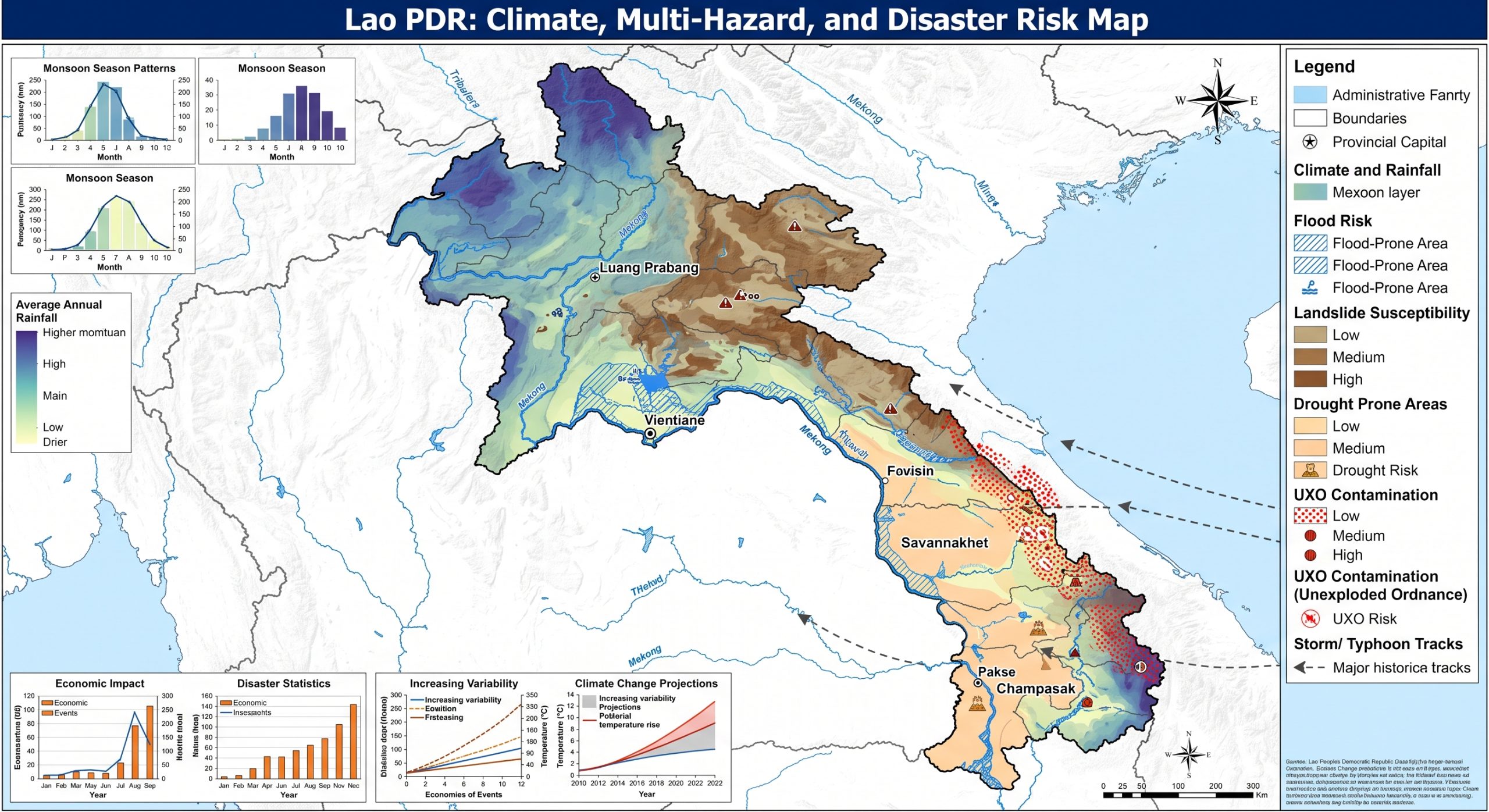
Lao PDR is highly exposed and vulnerable to climate change and multi-hazard risks, particularly floods, flash floods, droughts, storms, landslides, erosion, heat stress, water-resource variability, agricultural losses, forest degradation, and climate-sensitive health risks. Its vulnerability is shaped by mountainous terrain, the Mekong River system, monsoon rainfall variability, dependence on rainfed agriculture, hydropower development, rural poverty, remote settlements, limited infrastructure resilience, and high reliance on natural resources. Climate change is expected to intensify these vulnerabilities through rising temperatures, changing rainfall patterns, more variable Mekong hydrology, increased flood and drought risk, heavier extreme rainfall, slope instability, reduced agricultural productivity, and growing pressure on food security, water resources, transport, energy, ecosystems, and vulnerable rural communities.

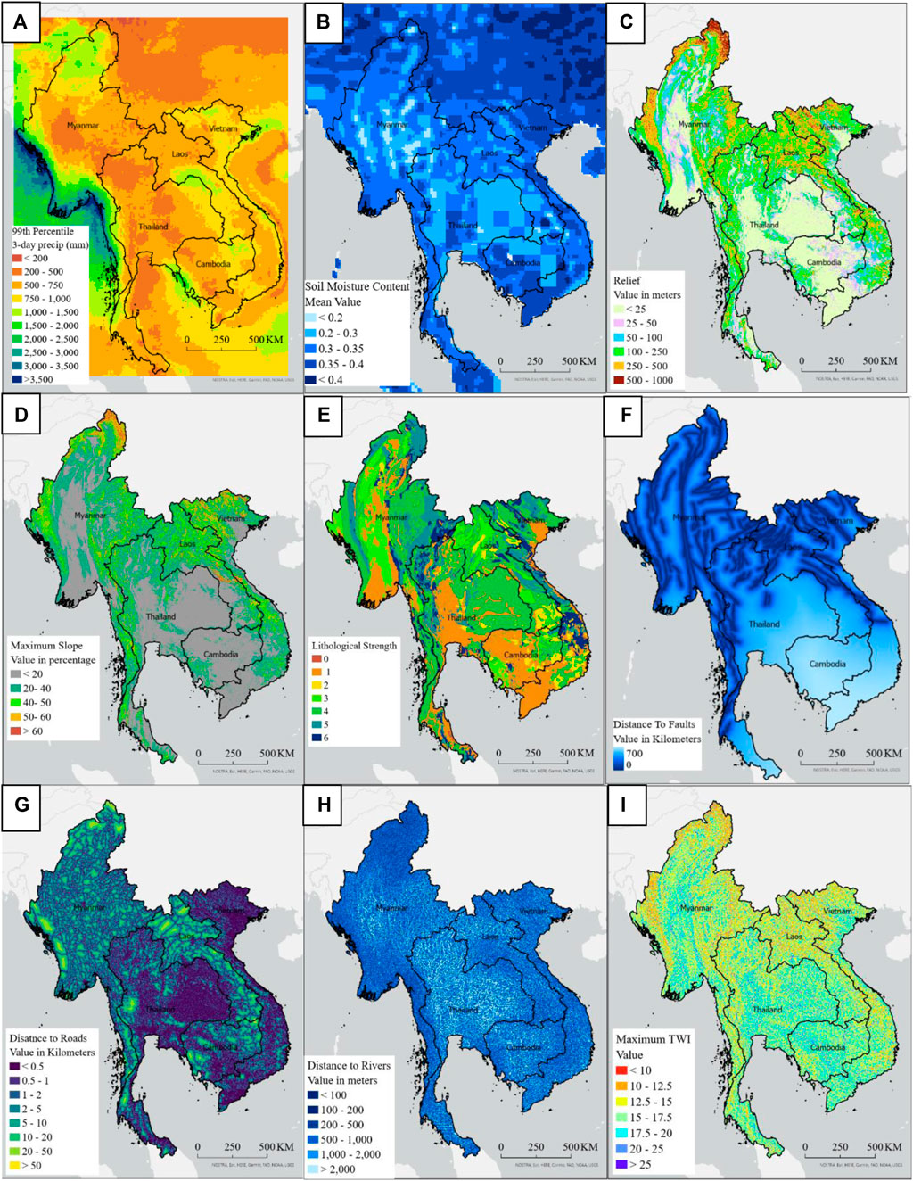
 1. Multi-hazard exposure
Lao People’s Democratic Republic is highly exposed and vulnerable to climate change and multi-hazard risks due to its mountainous terrain, dependence on the Mekong River system, monsoon rainfall variability, high reliance on rainfed and subsistence agriculture, hydropower development, natural-resource dependence, rural poverty, remote settlements, and limited infrastructure resilience. The country faces recurrent risks from floods, flash floods, droughts, storms, landslides, erosion, heat stress, water-resource variability, agricultural losses, forest degradation, and climate-sensitive health impacts. Climate change is expected to intensify these vulnerabilities through rising temperatures, changing rainfall patterns, greater Mekong hydrological variability, more severe floods and droughts, heavier extreme rainfall, slope instability, reduced agricultural productivity, and growing pressure on food security, water resources, hydropower, transport, ecosystems, and vulnerable rural communities. Strengthening multi-hazard early warning systems, impact-based forecasting, flood and drought risk management, landslide risk reduction, climate-resilient agriculture, watershed restoration, resilient infrastructure, disaster risk financing, and locally led adaptation is essential to reduce losses and protect Lao PDR’s development gains.

Lao PDR is exposed to high climate and disaster risks, with droughts, floods, and storms identified by GFDRR as the most prevalent hazards, and these hazards are expected to become more severe under climate change. GFDRR also notes that the 2015–2016 El Niño affected the country through lower agricultural yields, reduced hydropower production, and storm damages. (GFDRR)
The country’s broader disaster-risk profile includes floods, landslides, droughts, tropical storms, and cyclones, while UXO contamination adds an additional development and safety challenge in many areas. From 1970 to 2010, Lao PDR recorded 33 natural hazard events, mostly floods and droughts, affecting almost 9 million people and causing more than US$400 million in economic damage.
2. Flood and Mekong River vulnerability
Flooding is the country’s dominant natural hazard, with the Mekong River as a primary source of flood risk. Floods affect riverine communities, lowland agricultural areas, rural roads, bridges, schools, health facilities, markets, and water systems. The World Bank estimated annual expected losses from flood events in Lao PDR at around 2.8% to 3.6% of GDP, while a high-impact flood occurring on average once every 100 years could generate losses equivalent to about 11.7% of GDP.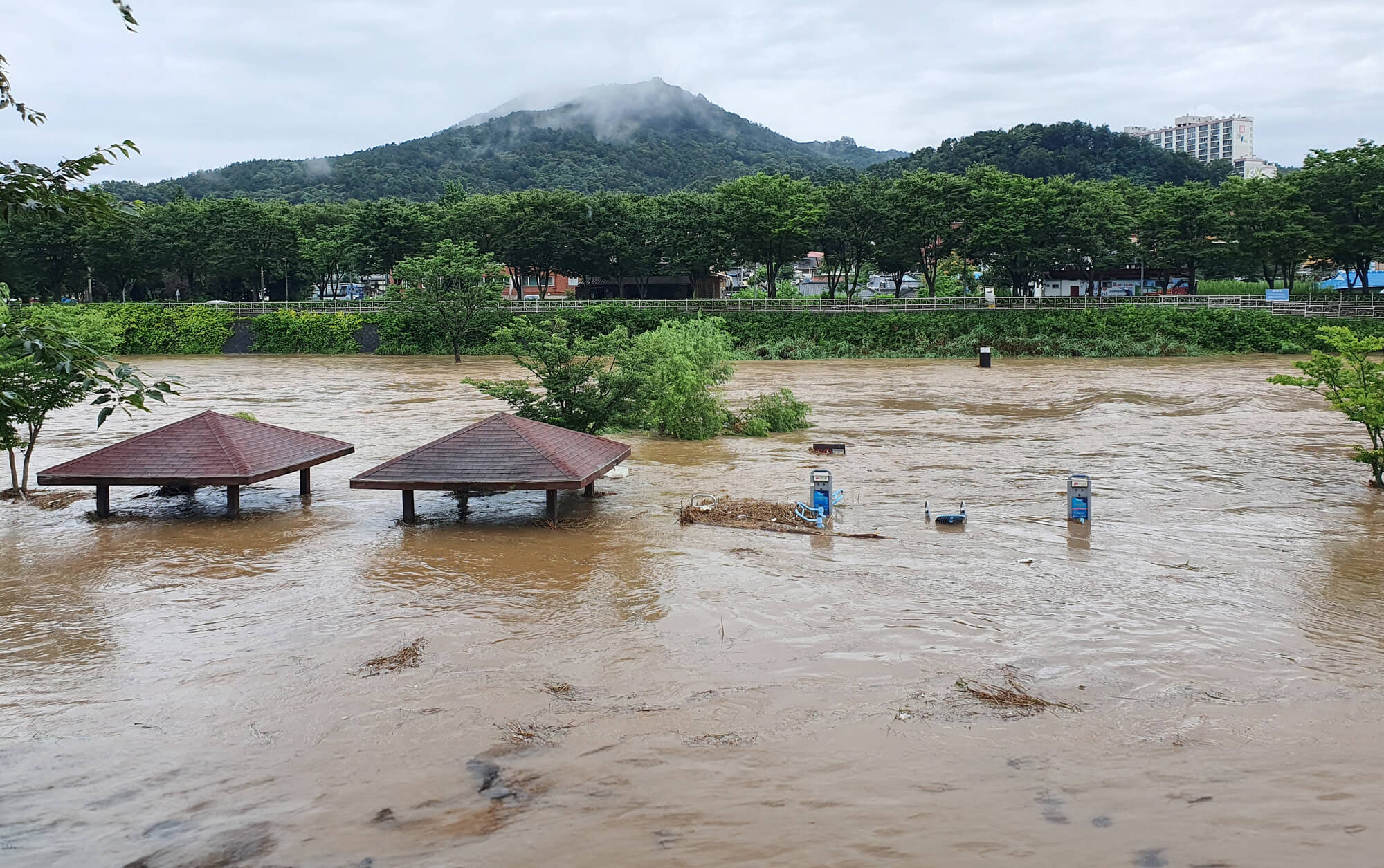
Flood risk is not uniform across the country. Riverine flooding is significant along the Mekong and its tributaries, while flash floods are a major concern in mountainous and steep catchments. Heavy rainfall can rapidly trigger floods, landslides, road washouts, riverbank erosion, crop losses, and isolation of remote communities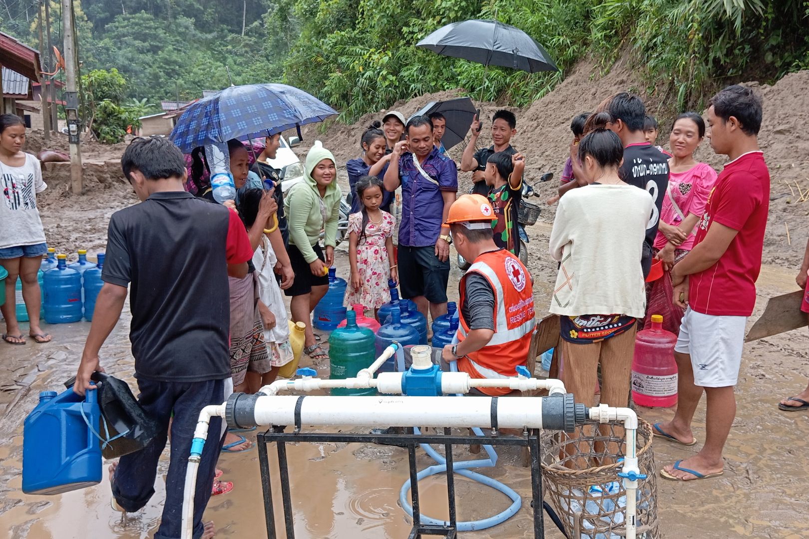
3. Drought and water-resource vulnerability
Drought is a major recurrent hazard, especially in areas dependent on rainfed agriculture, small reservoirs, shallow groundwater, and seasonal water availability. Drought affects rice production, livestock, fisheries, hydropower generation, drinking-water availability, and rural livelihoods. GFDRR specifically notes that the 2015–2016 El Niño reduced agricultural yields and hydropower production, showing how drought can create cascading impacts across food, energy, and income systems. (GFDRR)
Climate change is expected to increase both flood and drought risk through rising temperatures, changing rainfall patterns, and greater variability in the hydrological regime of the Mekong River. Historical records from 1951 to 2012 show warming of about 0.1°C per decade and rainfall increases averaging around 1.6 mm per decade, while future changes are expected to increase climate variability and water-management challenges.
4. Landslide, erosion, and mountain vulnerability
Because much of Lao PDR is mountainous, landslide and erosion risks are significant. Heavy rainfall, steep slopes, deforestation, road construction, mining, shifting cultivation, and weak slope stabilization can combine to trigger landslides and debris flows. These hazards damage rural roads, bridges, houses, agricultural land, irrigation systems, schools, and health posts.
Mountain communities are especially vulnerable because a landslide or washed-out bridge can isolate entire villages, delay emergency response, disrupt market access, and affect food supply. Landslide risk is therefore closely connected to transport resilience, rural development, watershed management, and land-use planning.
5. Agriculture, food security, and livelihood vulnerability
Agriculture is one of Lao PDR’s most climate-sensitive sectors. GFDRR notes that agriculture accounts for about 24% of GDP and 64% of employment, while around 80% of the Lao population practices subsistence agriculture. This means climate shocks directly affect livelihoods, income, food security, poverty, and recovery capacity. (GFDRR)
The 2018 Post-Disaster Needs Assessment also emphasized that roughly 70% of the population works in agriculture, which is heavily affected by climate-related events. Increased climate variability is projected to have serious impacts on crops, livestock, fisheries, and human health, with poor and vulnerable households expected to be most affected because they have fewer options to manage risk.
Key agricultural risks include:
| Sub-sector | Main climate risks |
|---|---|
| Rice production | Floods, droughts, delayed rains, crop-calendar disruption, water stress |
| Upland farming | Soil erosion, landslides, rainfall variability, land degradation |
| Livestock | Heat stress, water scarcity, disease risks, pasture degradation |
| Fisheries | River-flow changes, drought, flood disruption, sedimentation, habitat change |
| Smallholder livelihoods | Crop failure, market disruption, debt, reduced food stocks |
| Rural infrastructure | Road damage, irrigation damage, reduced access to inputs and markets |
6. Hydropower, energy, and infrastructure vulnerability
Lao PDR’s development model is strongly linked to natural-resource sectors, particularly hydropower, mining, and infrastructure development. The Mekong and its tributaries support hydropower generation, but hydropower is climate-sensitive because drought reduces water availability while extreme rainfall and floods can create dam-safety, sedimentation, spillway, and downstream flood-management risks.
The country’s economy has relied heavily on large-scale investments in mining and hydropower, but this has also contributed to natural-resource depletion and environmental degradation. UNEP’s country fiche reports that environmental degradation costs were estimated at 19.3% of GDP in 2017, highlighting the importance of integrating climate resilience, ecosystem protection, and risk screening into development planning. (Interactive Country Fiches)
Transport infrastructure is also highly exposed. Rural roads, bridges, culverts, and mountain routes are vulnerable to floods, landslides, erosion, and extreme rainfall. Road disruption can isolate communities, interrupt trade, delay emergency response, and limit access to schools, health services, and markets.
7. Urban and settlement vulnerability
Lao PDR is experiencing rapid urbanization, especially in Vientiane and secondary towns. Rapid urban growth can increase exposure to urban flooding, drainage congestion, waste-related blockage of waterways, heat stress, and infrastructure overload. UNEP notes that Lao PDR is experiencing rapid urbanization, creating new development challenges for the country. (Interactive Country Fiches)
Urban vulnerability is highest where poor drainage, informal settlements, low-lying land, weak solid-waste management, and floodplain development overlap. In rural areas, vulnerability is shaped by remoteness, weak housing, limited road access, dependence on natural resources, and limited access to early warning and recovery finance.
8. Sector-specific vulnerability summary
| Sector | Main climate and multi-hazard risks |
|---|---|
| Agriculture and food security | Floods, droughts, delayed rains, crop losses, livestock stress, erosion, pests |
| Water resources | Mekong flow variability, drought, flood contamination, sedimentation, competing water demand |
| Hydropower and energy | Drought-related low generation, flood risks, sedimentation, infrastructure exposure |
| Transport infrastructure | Landslides, road washouts, bridge damage, slope failure, rural isolation |
| Urban settlements | Urban flooding, poor drainage, heat stress, informal settlement exposure |
| Forests and ecosystems | Deforestation, land degradation, erosion, biodiversity loss, watershed degradation |
| Health | Heat stress, waterborne disease, vector-borne disease, flood-related service disruption |
| Public finance | Disaster recovery costs, damaged public assets, pressure on emergency budgets |
9. Social vulnerability
The most vulnerable groups include smallholder farmers, subsistence farming households, ethnic minority communities, upland communities, remote rural villages, women-headed households, children, older persons, people with disabilities, informal urban settlers, and households living in flood-prone, drought-prone, landslide-prone, or erosion-prone areas.
Vulnerability is highest where climate exposure overlaps with poverty, limited livelihood diversity, weak infrastructure, low savings, limited insurance coverage, poor access to early warning, and difficult physical access during emergencies. GFDRR highlights that poor households suffer the greatest disaster consequences because of higher vulnerability and reduced capacity to recover. (GFDRR)
10. Priority resilience needs
Lao PDR’s resilience agenda should prioritize multi-hazard early warning systems, flood forecasting, drought monitoring, landslide risk mapping, impact-based forecasting, climate-resilient agriculture, watershed management, resilient rural roads, hydropower risk management, urban drainage improvement, climate-health surveillance, disaster risk financing, and locally led adaptation.
A practical resilience package for Lao PDR should include:
| Priority area | Key actions |
|---|---|
| Early warning and anticipatory action | Impact-based warnings for floods, droughts, storms, landslides, heat, and river-level changes |
| Flood and landslide risk reduction | River-basin forecasting, slope-risk mapping, drainage improvement, road stabilization |
| Climate-resilient agriculture | Drought- and flood-tolerant crops, climate advisories, crop diversification, irrigation efficiency |
| Water and hydropower resilience | Mekong hydrological monitoring, dam-safety coordination, drought planning, sediment management |
| Rural infrastructure resilience | Climate-resilient roads, bridges, culverts, schools, health facilities, and water systems |
| Watershed and ecosystem restoration | Reforestation, soil conservation, erosion control, sustainable land management |
| Urban resilience | Stormwater drainage, flood zoning, waste management, heat-risk planning |
| Disaster risk financing | Contingency finance, scalable social protection, insurance options, resilient recovery funding |
Lao PDR’s adaptation priorities already focus on critical sectors including agriculture, forestry, water resources, transport and urban development, public health, and energy, which are the core systems requiring climate-resilient investment and risk-informed planning. (Lao PDR NDC)
The National Disaster Management Office of Lao People Democratic Republic was established in 1997 with support from UNDP (reinforcing action of the Ministry of Labor and Social Welfare). NDMO focuses on four functions as relief, disaster management planning, information and dissemination and training.

Context
Natural Hazard Risk
Lao People’s Democratic Republic (PDR) is exposed to high climate and disaster risks. Droughts, floods, and storms are the most prevalent hazards, and are expected to become more severe with climate change. Three of the five costliest natural disasters have taken place since 2009, including two floods in 2013. The 2015–16 El Niño, one of the strongest on record, impacted the country through lower yields, reduced hydropower production, and storm damages.
These events have significant impacts on the agriculture sector, a critical part of the economy, representing about 24 percent of gross domestic product and 64 percent of employment. The poor have suffered the brunt of disaster consequences in the aftermath of disasters, due to their higher vulnerability and reduced ability to recover. About 80 percent of the Lao population practices subsistence agriculture and lives on less than $2.5 per day.
Government Priorities
Lao PDR has incorporated disaster risk management (DRM) in its policies and institutions. With support from GFDRR, the government integrated climate risks and measures in its main planning documents, including a scaled-up focus on DRM in the Eighth National Socio-Economic Development Plan (2016–20). Key sectoral policies and strategies in agriculture, environment, housing, and transport have integrated climate and disaster risk considerations.
The Ministry of Natural Resources and Environment introduced DRM and climate change in its Vision 2030, Strategy 2025, and Action Plan 2020––in consort with a 2010 National Strategy on Climate Change. In 2017, the Ministry of Planning and Investment, with World Bank support, decreed climate and disaster risk considerations in the public investment review process. A climate change and disaster management law is currently being developed, together with a new five-year National Strategic Disaster Risk Management Plan.
The government also developed disaster risk financing mechanisms. The State Reserve Fund, established in 2013 under the Ministry of Finance, includes 3 percent of the annual expenditure budget. The Social Welfare Fund, established in 2015 under the Ministry of Social Welfare, covers disaster emergency relief.
To further advance its DRM agenda, government priorities include:
- Advancing legal frameworks to support DRM;
- Strengthening the disaster and climate resilience of the transport sector; and,
- Strengthening government capacity to respond to natural disaster events.
GFDRR progress to date
GFDRR has supported disaster risk management activities in Lao PDR since 2008. Following Typhoons Ketsana in 2009 and Haima in 2011, GFDRR supported damage and loss assessments that estimated losses at over $58 million and $63 million, respectively. The assessments helped leverage post-disaster funding from the government and donors and laid the groundwork for risk reduction activities. GFDRR helped rehabilitate damaged infrastructure and strengthened the government’s capacity to carry out future post-disaster assessments through trainings and developing a handbook.
GFDRR support has helped strengthen the legal framework for hydro-meteorological services and formulate a national strategy and standard operating procedures for early warning. Provincial and national risk profiles and a value for money strategy in reconstruction were also developed. With GFDRR assistance, DRM has been integrated in a urban development law and socioeconomic development plans at the national level and in the three provinces affected by Typhoon Ketsana.
GFDRR support is enabling improved disaster risk financial resilience in Lao PDR. Building on its 2012 report, “Advancing Disaster Risk Financing and Insurance in ASEAN Member States,” GFDRR crafted a feasibility study for risk financing and insurance options, enabling improved understanding of risk risk-informed decision-making. GFDRR has also supported a proposed Southeast Asia Disaster Resilience Insurance Facility for Cambodia, Lao PDR, and Myanmar. This would be the first regional catastrophe risk pool in Asia, building on similar GFDRR-supported initiatives in the Caribbean and in the Pacific.
Additionally, GFDRR support is helping the government develop DRM investment plans. This includes an integrated urban flood risk management plan for Muang Xay and major transport hubs in northern Laos and the capital city of Oudomxay Province. These efforts support preparing World Bank’s $30 million Lao PDR Southeast Asia Disaster Risk Management Project. GFDRR is also helping to improve the disaster and climate resilience of Lao PDR’s transport sector, with critical sections of selected provincial and district roads identified for interventions. These activities feed into a World Bank $25 million Lao road connectivity project.
GFDRR anticipates continued demand from the Government of Lao PDR to support:
- Promoting an integrated urban flood risk management;
- Strengthening the disaster and climate resilience of the transport sector;
- Strengthening disaster financial resilience; and,
- Enhance government capacity for DRM.
Important Documents
https://drive.google.com/drive/folders/1hYLsbzcvftUnk29VNfCfDEPXf0Qn8jRg?usp=drive_link
