MHEWC to conduct Comprehensive Multi-Hazard Early Warning System (MHEWS) Assessments
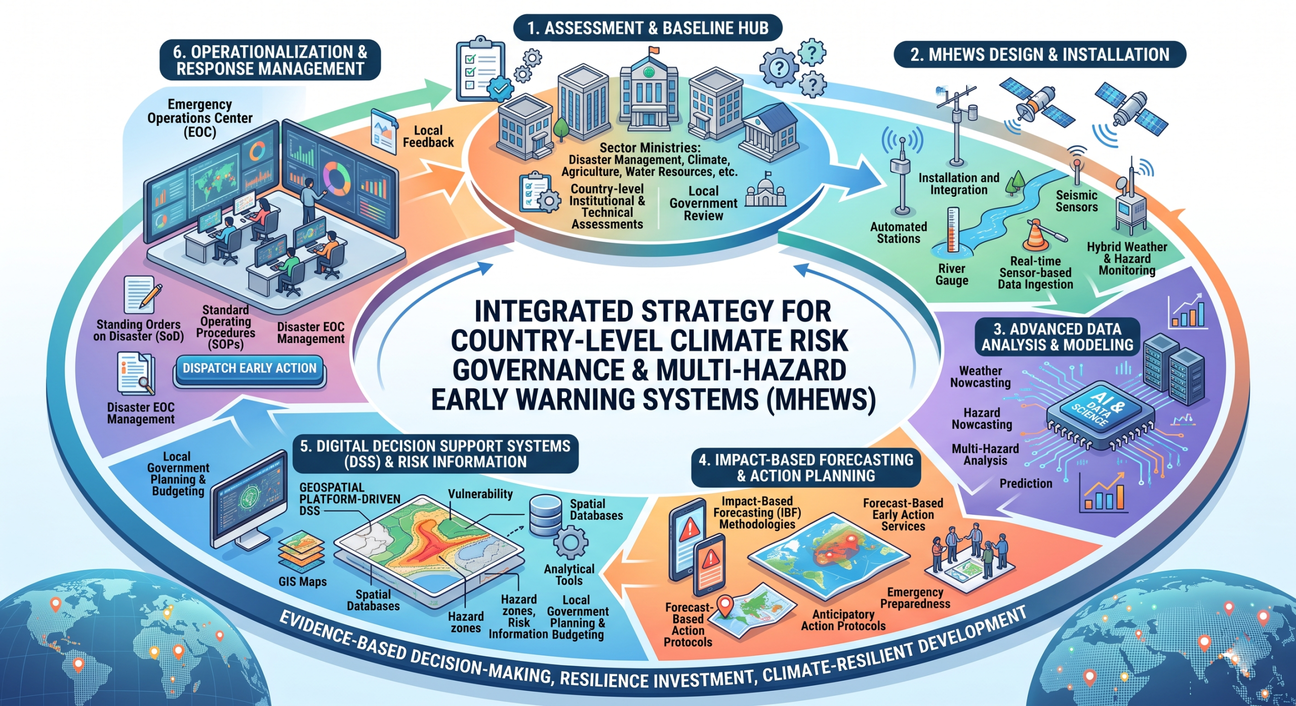
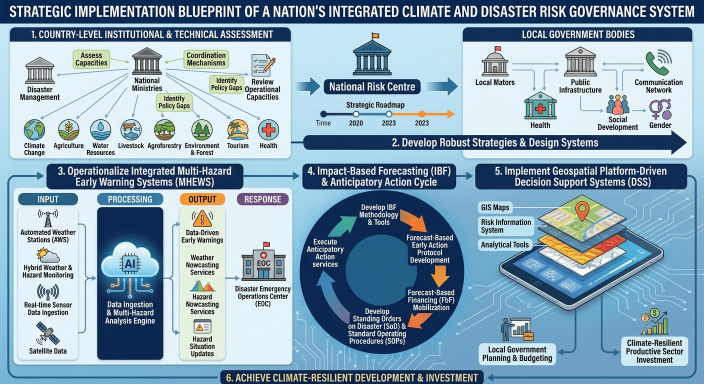
- Conduct country-level institutional and technical assessments of sector ministries and affiliated climate-vulnerable departments, including Disaster Management, Climate Change, Agriculture, Water Resources, Livestock, Fisheries, Agroforestry, Environment & Forest, Tourism, Health, Public Infrastructure, Communication Network, Social Development, Gender and other relevant sectors.
- Assess national climate risk governance systems by reviewing relevant local government and planning institutions, including ministries responsible for local government, decentralized local authorities, development planning, economy and finance, and blue economy. This will include identifying institutional arrangements, coordination mechanisms, policy gaps, and operational capacities related to climate risk management, multi-hazard disaster risk governance, and resilience planning.
- Develop robust strategies and support the design and implementation of informed climate risk management, disaster risk governance, and multi-hazard risk reduction systems.
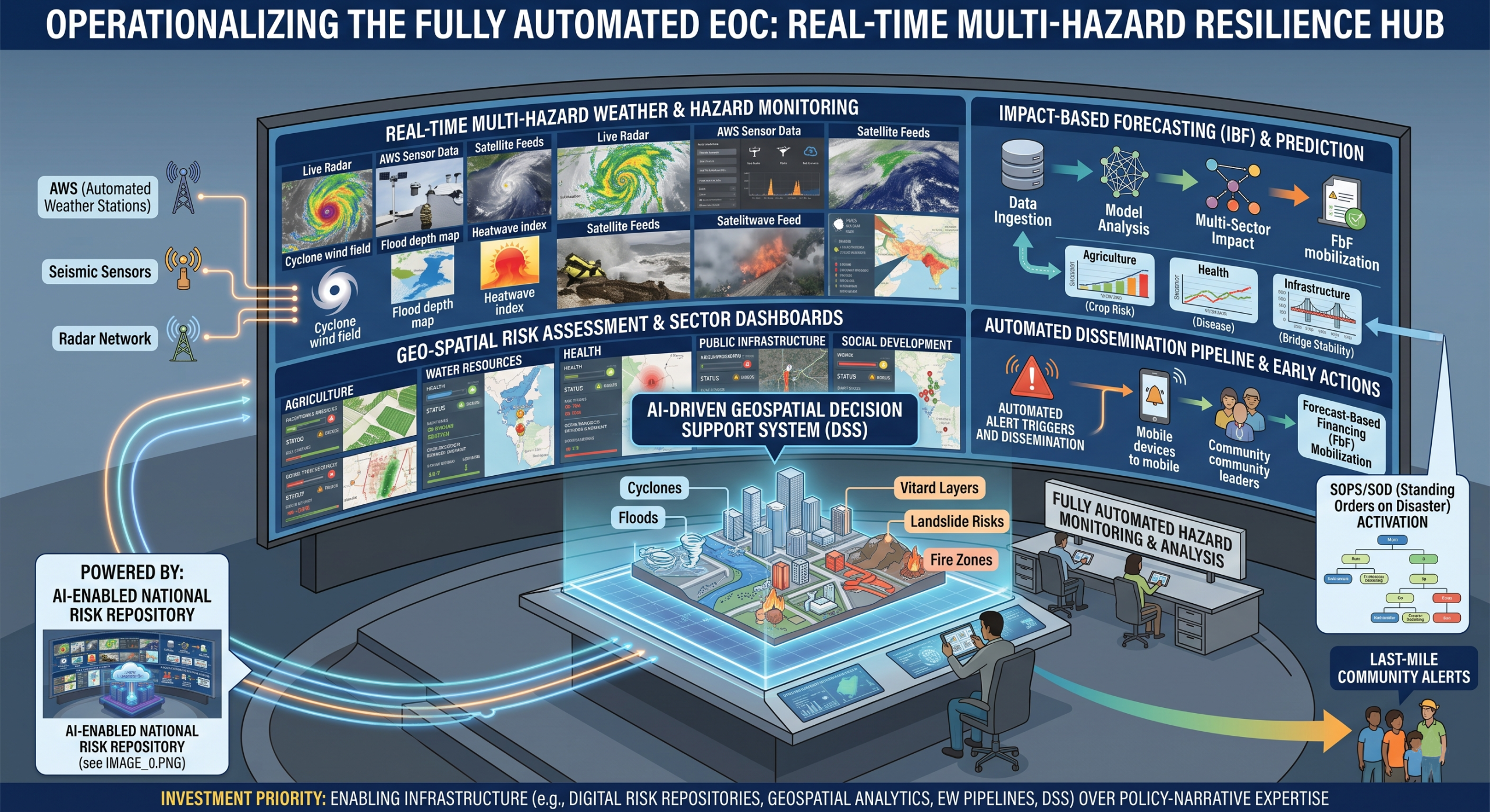
- Design and implement end-to-end Multi-Hazard Early Warning Systems (MHEWS), including the installation and integration of Automated Weather Stations (AWS), hybrid weather and hazard monitoring systems, real-time sensor-based data ingestion, data-driven early warning systems, weather nowcasting services, hazard nowcasting services, and hazard event situation update mechanisms.
- Develop methodologies, tools, guidelines, frameworks, and action plans for Impact-Based Forecasting (IBF), Forecast-Based Early Action, anticipatory action services, forecast-based emergency preparedness and response management systems, Forecast-Based Financing (FbF) mobilization, and Early Action Protocol development.
- Develop forecast-based geospatial Decision Support System (DSS)-supported Standing Orders on Disaster (SoD), Standard Operating Procedures (SOPs), and operational protocols for preparedness, response, and anticipatory action.
- Design, implement, and operationalize fully automated systems for hazard detection, monitoring, prediction, multi-hazard analysis, and Disaster Emergency Operations Center (EOC) management.
- Conduct climate and multi-hazard risk and vulnerability assessments to support evidence-based decision-making, sector planning, and resilience investment.
- Design and implement geospatial platform-driven Decision Support Systems for disaster risk governance, climate risk management, and multi-hazard early warning operations.
- Develop GIS maps, spatial databases, risk information systems, and analytical tools to support local governments and productive sectors in risk-informed planning, budgeting, investment prioritization, and climate-resilient development.
MHEWC conducts Disaster Risk Management Governance System Assessment for the countries
The assessment of the Disaster Risk Management (DRM) governance system will examine the institutional, technical, operational, human-resource, coordination, planning, information-management, and accountability capacities required for effective multi-hazard disaster risk management. The assessment will cover the following areas:
1. Institutional Structure and Technical Capacity
- Assess the existing institutional structure, mandates, roles, responsibilities, and coordination arrangements of institutions responsible for disaster risk management, meteorological services, hydrological services, geological monitoring, environmental monitoring, and other National Meteorological and Hydrological Services-related functions.
- Review institutional technical capacities for undertaking observation, monitoring, forecasting, risk assessment, warning generation, emergency coordination, disaster preparedness, response, recovery, and reconstruction activities.
- Assess the availability, qualifications, competencies, deployment, and retention of technical human resources required to perform meteorological, hydrological, climate, geospatial, early warning, risk assessment, emergency management, and information and communication technology functions.
- Identify institutional and technical human-resource gaps, including staffing shortages, competency gaps, training needs, succession-planning requirements, and dependence on external technical assistance.
2. Institutional ICT Infrastructure and Data-Management Capacity
- Assess existing institutional information and communication technology structures, governance arrangements, technical support mechanisms, and ICT management responsibilities.
- Review the availability, functionality, adequacy, interoperability, security, and maintenance of ICT facilities, including:
- Data centres and server infrastructure;
- Workstations and computing facilities;
- Communication networks;
- Internet and intranet connectivity;
- Cloud-based systems;
- Data-storage and backup facilities;
- Cybersecurity systems;
- Emergency communication equipment;
- Data-transmission systems; and
- Power backup and system-redundancy arrangements.
- Assess the adequacy and compatibility of institutional hardware, software, databases, analytical platforms, forecasting systems, GIS applications, remote-sensing tools, dashboards, mobile applications, and decision-support systems.
- Review institutional capacity for data acquisition, ingestion, validation, processing, analysis, storage, visualization, dissemination, archiving, recovery, and sharing.
- Assess data-governance arrangements, including data ownership, standards, quality assurance, metadata management, access rights, confidentiality, interoperability, data-sharing protocols, and institutional responsibilities.
3. Institutional Partnership, Coordination, and Accountability Framework
- Assess existing partnership and coordination arrangements among sector ministries, government departments, technical agencies, local governments, emergency services, humanitarian actors, civil society organizations, academic institutions, the private sector, media organizations, and development partners.
- Review the effectiveness of horizontal coordination across sectors and vertical coordination between national, provincial, district, municipal, and community levels.
- Assess the clarity of institutional mandates, reporting lines, decision-making authority, operational responsibilities, and accountability mechanisms.
- Examine the level of stakeholder participation and institutional ownership within an integrated and multi-sectoral DRM governance framework.
- Assess the availability and effectiveness of:
- Memoranda of understanding;
- Inter-agency agreements;
- Standard operating procedures;
- Data-sharing agreements;
- Emergency coordination protocols;
- Joint planning mechanisms;
- Sector working groups;
- National and local DRM platforms; and
- Monitoring and accountability frameworks.
- Identify institutional overlaps, coordination gaps, fragmented responsibilities, duplication of functions, and areas where accountability remains unclear.
4. National Disaster Management Agency Risk-Governance Capacity
- Assess the institutional, legal, policy, strategic, technical, financial, and operational capacity of the National Disaster Management Agency or equivalent authority.
- Review the agency’s ability to provide national leadership, policy direction, coordination, oversight, technical guidance, and operational support for disaster risk management.
- Assess institutional capacity for:
- Multi-hazard risk and vulnerability assessment;
- Exposure and vulnerability analysis;
- Disaster-risk profiling;
- Climate-risk assessment;
- Risk mapping;
- Disaster-loss and damage data management;
- Preparedness and contingency planning;
- Emergency coordination;
- Early warning and anticipatory action;
- Recovery and reconstruction planning;
- Disaster-risk financing; and
- Monitoring and evaluation.
- Review the agency’s capacity to translate risk information into policies, plans, investment decisions, preparedness actions, emergency operations, and resilient recovery programmes.
- Assess the availability of technical guidelines, operational manuals, assessment methodologies, planning tools, information systems, and qualified personnel.
5. Emergency Operations Centre Capacity
The Emergency Operations Centre assessment will examine its physical setup, system architecture, ICT infrastructure, technical capacity, operational readiness, functional arrangements, and linkages with field-level institutions.
The assessment will cover:
- EOC location, accessibility, physical security, workspace design, and operational layout;
- Command, control, coordination, communication, and information-management arrangements;
- Incident-management and emergency decision-making structures;
- EOC system architecture and technical design;
- ICT infrastructure, servers, computers, displays, dashboards, communication equipment, software platforms, databases, and backup systems;
- Integration with meteorological, hydrological, geological, health, security, humanitarian, and local-government information systems;
- Availability of emergency communication channels, including radio, telephone, satellite communication, mobile communication, email, web-based platforms, and mass-notification systems;
- Operational staffing, duty rosters, surge arrangements, technical support, and round-the-clock operational capacity;
- Standard operating procedures, activation protocols, escalation procedures, incident-action planning, reporting procedures, and deactivation arrangements;
- Capacity for receiving, integrating, validating, analysing, and visualizing field-level information;
- Capacity for processing situation reports, damage information, needs information, resource requests, operational updates, and early warning information;
- Field-level data-ingestion arrangements through mobile applications, survey tools, local government systems, sensors, monitoring stations, emergency responders, community volunteers, and humanitarian partners;
- Interoperability between national, subnational, district, municipal, and field-level emergency coordination systems;
- Data backup, cybersecurity, system redundancy, business continuity, and disaster-recovery arrangements;
- EOC simulation exercises, testing, maintenance, after-action reviews, and continuous improvement mechanisms.
Integrated Disaster Risk Management Planning Capacity
6. Risk-Informed DRM Planning Capacity
- Assess institutional capacity to develop and implement risk-informed disaster preparedness, emergency response, recovery, reconstruction, and resilience plans.
- Review whether DRM planning processes are informed by:
- Hazard assessments;
- Exposure and vulnerability data;
- Climate projections;
- Historical disaster-loss information;
- Multi-hazard risk scenarios;
- Impact-based forecasts;
- Critical infrastructure analysis;
- Community risk assessments; and
- Social, economic, environmental, and gender considerations.
- Assess the integration of sector ministries and departments in national and subnational DRM planning processes.
- Review the extent to which DRM is mainstreamed into sectoral plans for:
- Agriculture and food security;
- Water resources;
- Health;
- Education;
- Transport;
- Energy;
- Housing;
- Urban development;
- Environment;
- Social protection;
- Telecommunications;
- Local government;
- Finance and planning; and
- Critical infrastructure.
- Assess linkages between DRM plans, climate-change adaptation plans, development plans, humanitarian preparedness plans, public-investment programmes, and local development plans.
- Review the quality, consistency, implementation status, financing arrangements, monitoring systems, and updating mechanisms of preparedness, contingency, response, recovery, and reconstruction plans.
- Assess whether plans contain clearly defined responsibilities, activation thresholds, timelines, resource requirements, operational procedures, coordination arrangements, and accountability mechanisms.
7. ICT Tools and Standing Orders During Emergencies
- Review the availability, adequacy, and operational application of Standing Orders on Disaster, emergency directives, contingency procedures, standard operating procedures, and incident-management protocols.
- Assess whether institutional standing orders clearly define:
- Roles and responsibilities;
- Chains of command;
- Warning authorization;
- Emergency activation procedures;
- Information-reporting requirements;
- Inter-agency coordination arrangements;
- Resource-mobilization procedures;
- Evacuation responsibilities;
- Search-and-rescue responsibilities;
- Emergency logistics;
- Public communication;
- Damage and needs reporting; and
- Recovery coordination.
- Assess the use of ICT tools for emergency preparedness and operations, including:
- Emergency dashboards;
- Decision-support systems;
- GIS-based common operational pictures;
- Mobile data-collection applications;
- Incident-reporting platforms;
- Resource-tracking systems;
- Early warning dissemination platforms;
- Emergency communication systems;
- Social-media monitoring tools;
- Situation-reporting systems;
- Digital contingency plans; and
- Inter-agency information-sharing platforms.
- Examine whether digital tools and standing orders are integrated, regularly tested, updated, understood by responsible institutions, and supported by adequate training and simulation exercises.
Post-Disaster Damage, Loss, and Needs Assessment
8. PDNA Institutional Structure and Stakeholder Engagement
- Assess the existing national institutional framework for conducting Post-Disaster Needs Assessments.
- Review the roles and responsibilities of the national disaster management authority, planning and finance ministries, sector ministries, national statistical agencies, local governments, technical institutions, humanitarian organizations, civil society, private-sector actors, development partners, and affected communities.
- Assess the availability of a designated lead institution, sector-assessment teams, technical working groups, coordination arrangements, reporting structures, and quality-assurance mechanisms.
- Review stakeholder engagement throughout the PDNA process, including:
- Assessment planning;
- Methodology selection;
- Data collection;
- Field verification;
- Sector analysis;
- Damage and loss estimation;
- Recovery-needs identification;
- Validation;
- Report preparation;
- Prioritization; and
- Recovery planning.
- Assess the participation of women, persons with disabilities, older persons, displaced populations, marginalized communities, local authorities, affected households, businesses, and civil society organizations.
9. Institutional Capacity to Conduct PDNA
- Assess national and sectoral capacity to plan, coordinate, undertake, validate, and report a comprehensive PDNA.
- Review the availability of qualified technical personnel in:
- Economics;
- Engineering;
- Infrastructure;
- Agriculture;
- Livelihoods;
- Social sectors;
- Environment;
- Disaster risk reduction;
- Climate change;
- Gender and social inclusion;
- Statistics;
- GIS and remote sensing;
- Finance;
- Recovery planning; and
- Monitoring and evaluation.
- Assess institutional experience in conducting rapid assessments, sector assessments, damage and loss assessments, humanitarian needs assessments, and recovery-needs assessments.
- Review capacity for estimating:
- Physical damage;
- Economic losses;
- Service-delivery disruptions;
- Human and social impacts;
- Environmental impacts;
- Livelihood impacts;
- Governance impacts;
- Recovery requirements;
- Reconstruction costs; and
- Disaster-risk-reduction and Build Back Better requirements.
- Assess arrangements for coordination, data validation, quality control, financial estimation, reporting, dissemination, and integration of PDNA findings into recovery and reconstruction planning.
10. PDNA Methodology, Guidelines, and Assessment Process
- Review the availability and application of nationally approved PDNA methodologies, guidelines, templates, sector tools, data standards, and reporting formats.
- Assess the alignment of national methodologies with internationally recognised approaches for damage, loss, human-impact, needs, recovery, and reconstruction assessment.
- Review the full PDNA process, including:
- Activation and institutional mobilization;
- Assessment scoping and planning;
- Formation of sector teams;
- Baseline data compilation;
- Field data collection;
- Damage and loss estimation;
- Human-impact and needs assessment;
- Recovery-needs identification;
- Build Back Better analysis;
- Sector prioritization;
- Cost estimation;
- Validation and quality assurance;
- Report preparation;
- Government endorsement;
- Recovery-framework development; and
- Monitoring of recovery implementation.
- Assess the availability and quality of baseline datasets, administrative records, census data, sector inventories, asset databases, land-use data, infrastructure data, household information, market information, and historical disaster-loss databases.
11. ICT, GIS, Remote Sensing, and UAV Capacity for PDNA
- Assess institutional capacity to use digital technologies for rapid and comprehensive post-disaster assessment.
- Review the availability and application of:
- Mobile data-collection tools;
- Digital survey applications;
- Cloud-based assessment platforms;
- GIS databases;
- Web-GIS portals;
- Remote-sensing imagery;
- Satellite data;
- Unmanned aerial vehicles;
- Drone-based imaging;
- Global positioning systems;
- Digital elevation models;
- Image-processing software;
- Damage-classification tools;
- Artificial intelligence-assisted analysis;
- Digital dashboards; and
- Decision-support systems.
- Assess capacity to acquire, process, analyse, interpret, validate, store, and disseminate geospatial and remote-sensing data.
- Review institutional arrangements for obtaining pre-disaster and post-disaster imagery, including access to satellite imagery, drone operations, aerial surveys, open-source geospatial data, and commercial data providers.
- Assess compliance with UAV regulations, flight permissions, operational safety procedures, data-protection requirements, and ethical standards.
- Review interoperability between field-assessment tools, sector databases, EOC systems, GIS platforms, national statistics systems, and recovery-planning systems.
- Assess capacity to produce:
- Damage maps;
- Affected-population maps;
- Infrastructure-impact maps;
- Agricultural damage maps;
- Flood-extent maps;
- Landslide inventories;
- Building-damage classifications;
- Accessibility and logistics maps;
- Recovery-priority maps; and
- Spatial recovery-investment plans.
12. Expected Assessment Outputs
The assessment should generate:
- A DRM governance and institutional-capacity assessment report;
- An institutional mandate, coordination, and accountability matrix;
- A technical and human-resource capacity-gap analysis;
- An ICT infrastructure, systems, and data-management assessment;
- An EOC technical, operational, and functional-capacity assessment;
- A risk-informed DRM planning and sector-integration assessment;
- A review of Standing Orders on Disaster and emergency ICT tools;
- A national PDNA capacity and institutional-readiness assessment;
- A PDNA methodology, tools, data, GIS, remote-sensing, and UAV capacity assessment;
- A prioritized institutional strengthening and capacity-development plan;
- Recommendations for legal, policy, institutional, technical, financial, and operational reforms; and
- A phased roadmap for strengthening national and subnational DRM governance, EOC operations, integrated planning, and post-disaster assessment capacity.
This can also be converted into an assessment matrix with indicators, assessment questions, data sources, scoring criteria, identified gaps, and recommended actions.
…………………………………………………………………………
We would like to explore potential scopes of work and partnership opportunities with the National Disaster Management Organization (NDMO), Climate Change Department, and relevant sector ministries & Sector Departments, Stakeholders, actors at the country level.
…………………………………………………………………………
Subject: Looking forward to the scope of work and partnership opportunity
To,
The Director( Relevant Agency)
Dear Sir
Greetings from the Multi-Hazard Early Warning System Design and Implementation Center (MHEWC).
MHEWC provides technical solutions to strengthen Disaster Risk Management (DRM) governance systems, climate and multi-hazard risk management, and end-to-end early warning system design and implementation. We would be pleased to offer technical support to the National Disaster Management Organization (NDMO) ( Climate Change and other relevant sector Ministries/Deparments) in the following areas:
a) Upgrading NDMO ’s existing web portal into a geospatial, database-driven, and app-enabled Decision Support System (DSS) to support real-time disaster risk governance, planning, preparedness, response, and recovery management.
b) Conducting climate and multi-hazard risk and vulnerability assessments, including the preparation of geospatial hazard, exposure, vulnerability, and risk maps, and the establishment of a centralized risk information repository and database management system.
c) Assessing existing monitoring, observation, and early warning capacities and supporting NDMO in the installation, enhancement, and integration of observation networks, including Automated Weather Stations (AWS), hybrid weather and hazard monitoring systems, and sensor-ingested real-time data systems linked to a functional DSS.
d) Designing and operationalizing end-to-end multi-hazard early warning systems, including weather and hazard nowcasting services, impact-based forecasting, forecast-based anticipatory early action, forecast-based emergency preparedness and response management, forecast-based financing, Early Action Protocol development, and DSS-supported Standing Orders on Disaster and Standard Operating Procedures.
e) Supporting automated hazard detection, monitoring, prediction, and emergency operations management, including the design, implementation, and operationalization of a Multi-Hazard and Disaster Emergency Operations Center (EOC).
f) Developing GIS, database, and information tool-driven local government and productive sector-level risk-informed planning and budgeting systems to strengthen disaster risk reduction, climate change adaptation, nature-based solutions, locally led adaptation, and resilience planning.
g) Reviewing and upgrading multi-hazard preparedness, response, and recovery plans across administrative levels and relevant priority sectors, in alignment with NDMO’s institutional mandate and national disaster management priorities.
h) Providing any additional technical assistance as may be required by NDMO to strengthen national-to-last-mile disaster risk governance and early warning capacities.
We would welcome the opportunity to discuss NDMO’s priorities and explore how MHEWC can support the development of a practical implementation roadmap for strengthening multi-hazard early warning, risk information, and disaster risk governance systems.
We look forward to your kind response.
Sincerely,
Z M Sajjadul Islam
Advisor
Multi-Hazard Early Warning System Design and Implementation Center (MHEWC)
Web: www.mhewc.org
Email: sajjad@mhewc.org , zmsajjad@gmail.com
Phone & WhatsApp: +88 01711 979179