Mission and Vision of Multi-hazard Early Warning System Design & Implementation Center (MHEWC) for supporting the Global South
![]()
Grassroots development practitioners, marginalized groups, local government departments, smallholder entrepreneurs, last-mile value chain actors, and frontline communities all urgently need real-time, actionable information. Yet in many countries, critical data remains trapped in silos, stored on shelves, locked in fragmented systems, or controlled through rigid bureaucratic processes. This prevents the flow of timely, risk-informed information, which is essential for climate resilience and effective development planning. As a result, vulnerable last-mile communities lack accessible, tailored risk information and simplified early warning tools. The MHEWC initiative aims to break these silos, democratize access to information, and deliver easy-to-use solutions for countries across the Global South.
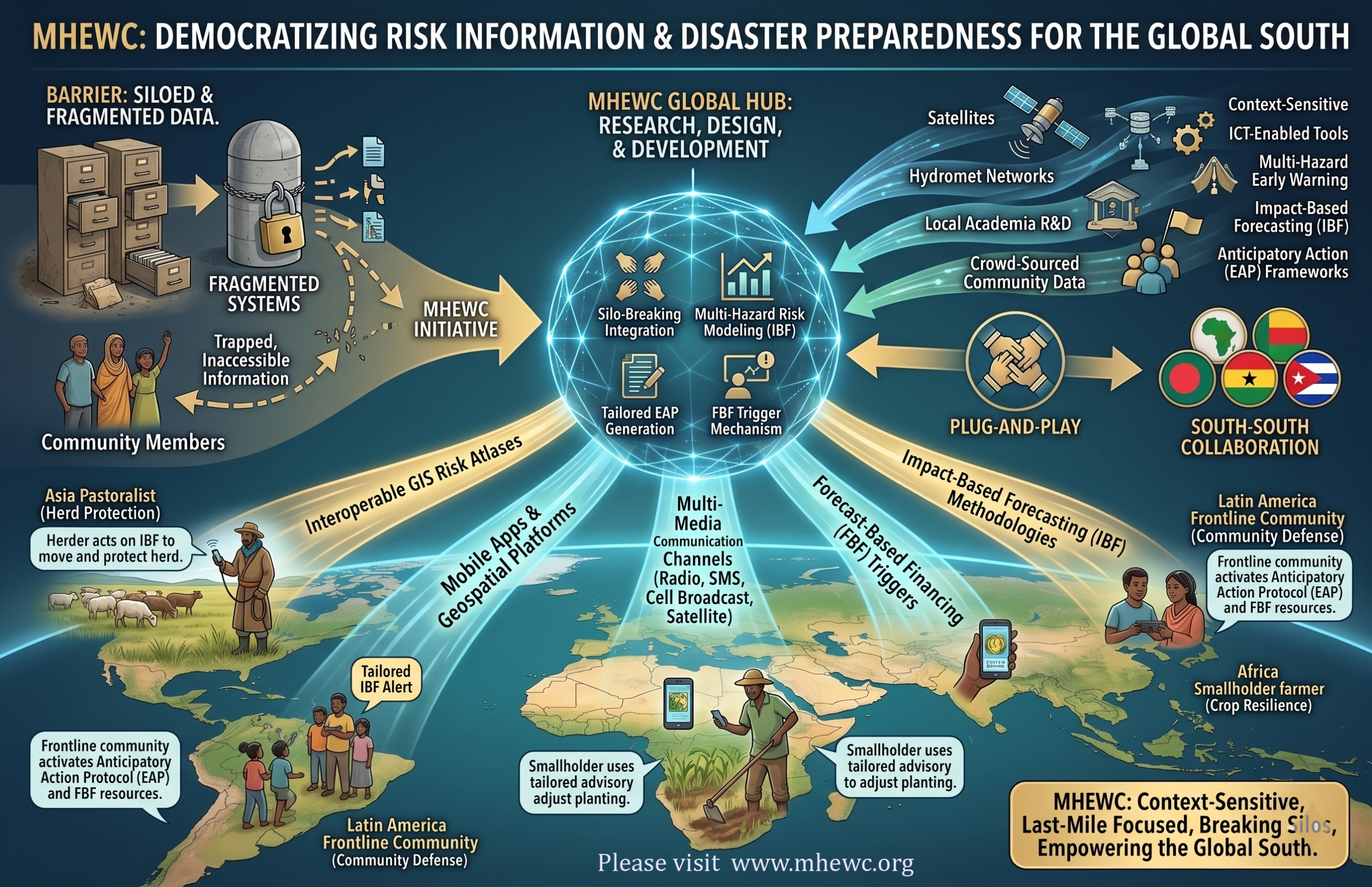
The Multi-Hazard Early Warning System Design & Implementation Center (MHEWC) is an emerging global platform that currently operates voluntarily, aiming to become a center of excellence in ICT-driven multi-hazard early warning systems (MHEWS). Its mission is to research, design, and develop robust, technology-enabled climate and multi-hazard risk-management hubs and tailored early-warning services.
MHEWC’s approach integrates county-level geography, topography, landscape-induced risks, and hydrometeorological vulnerabilities to ensure that early warning and risk management systems are context-sensitive and last-mile focused. It also seeks to address persistent barriers to effective risk governance, including weak multi-stakeholder coordination, sectoral misalignment, limited institutional capacity, and insufficient engagement of local R&D and academic institutions.
The Center provides comprehensive institutional assessments covering climate and multi-hazard risk governance structures, risk-assessment capacity, informed-planning tools, service-delivery gaps, and capacity-building needs to help countries develop a clear roadmap for strengthening their systems.
Functioning as a plug-and-play model, MHEWC harmonizes local expertise with proven south–south knowledge, tools, and affordable solutions to close operational gaps in risk management. Through this campaign, MHEWC promotes South–South collaboration on climate change and disaster risk management across Asia, Africa, and Latin America.
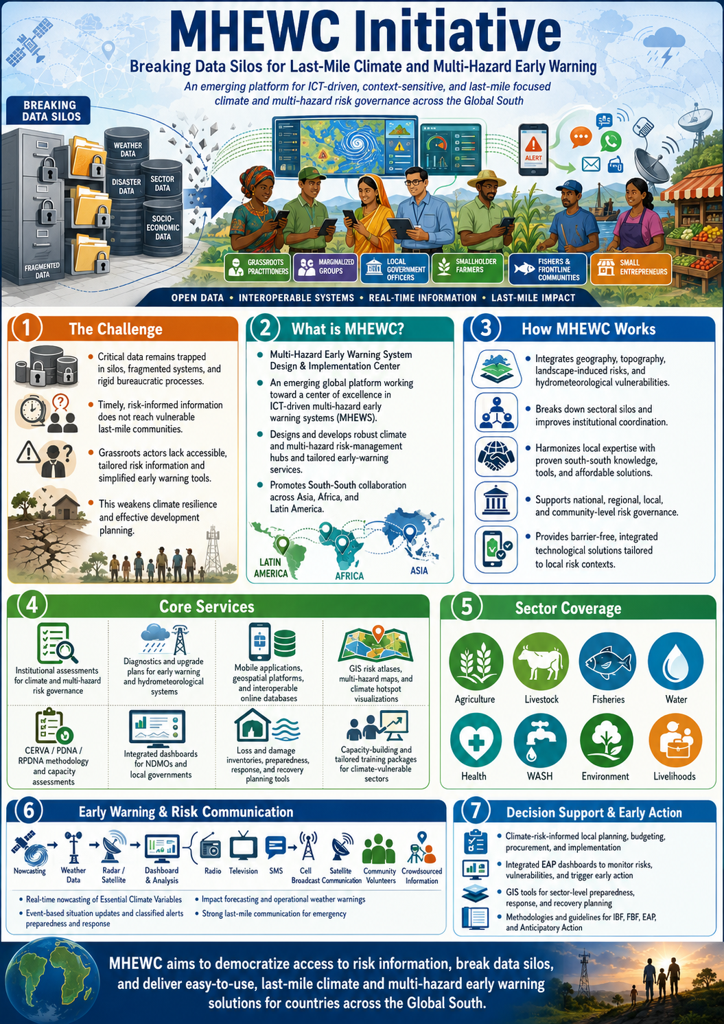
MHEWC aims to strengthen climate and multi-hazard risk governance by breaking down sectoral silos, improving institutional coordination, and deploying ICT-enabled tools, such as mobile applications, geospatial platforms, and interoperable online databases, to support climate-vulnerable sectors. It serves as an independent, barrier-free platform providing robust, integrated technological solutions tailored to local risk contexts.
MHEWC offers support for establishing new systems, diagnosing the operational capacity of existing early warning and hydrometeorological systems, and upgrading national MHEWC structures. Its ICT-driven integrated system connects climate-vulnerable sector departments, stakeholders, value-chain actors, and frontline communities to ensure seamless impact forecasting, operational weather warnings, and the dissemination of classified alerts.
The system design includes real-time nowcasting of Essential Climate Variables, event-based situation updates, and a strong risk-communication infrastructure using radio, television, SMS, cell broadcasts, satellite communication, community volunteers, and crowd-sourced information. This supports emergency preparedness and response during fast-onset hazard events.
MHEWC intended to promote digital, interoperable, and virtual local risk governance by addressing coordination and data-sharing barriers across national, regional, local, and community levels. It also evaluates national hydrometeorological services, institutional capacities, multi-hazard forecasting systems, storm surge and tropical storm warning capabilities, and provides comprehensive upgrade plans, methodologies, tools, and guidelines.
It conducts detailed assessments of vulnerability analysis methodologies, institutional capacity for CERVA/PDNA/RPDNA. It develops online geospatial and physical databases, GIS risk atlases, multi-hazard maps, and climate hotspot visualizations. MHEWC also provides full toolsets and process improvements for MIS/GIS systems.
Capacity-needs assessments and tailored training packages are developed for all climate-vulnerable sectors: agriculture, livestock, fisheries, water, health, WASH, environment, and livelihoods, to strengthen their ability to conduct risk and vulnerability assessments and to adopt ICT-integrated governance solutions.
MHEWC designs integrated dashboards for the National Disaster Management Organization (NDMO) and local governments to monitor risks, vulnerabilities, loss and damage inventories, and trigger early action through integrated EAP frameworks. It also develops GIS tools for sector-level preparedness, response, and recovery planning, and supports climate-risk-informed local government planning, budgeting, procurement, and implementation across key sectors.
Finally, MHEWC provides complete methodologies, tools, and guidelines for Impact-Based Forecasting (IBF), Forecast-Based Financing (FBF), Early Action Protocols (EAP), and Anticipatory Action frameworks.