Climate, multi-hazard disaster risk and vulnerability profile of South Sudan
1. Overall risk profile
South Sudan is one of the world’s most climate-vulnerable and disaster-fragile countries. Its risk profile is dominated by extreme flooding, riverine floods, long-duration inundation, drought, water scarcity, extreme heat, wildfire, food insecurity, disease outbreaks, displacement and conflict-climate interactions. The country’s disaster risk is not only a function of hazard exposure; it is intensified by conflict, weak infrastructure, low institutional capacity, poverty, limited hydrometeorological monitoring, dependence on rainfed livelihoods, and very low coping capacity. The World Bank’s 2026 Country Climate and Development Report describes South Sudan as trapped in a cycle of fragility, conflict and climate vulnerability, with climate change acting as a threat multiplier for displacement, food insecurity, resource conflict and social dislocation. Around 80% of the population depends on climate-vulnerable livelihoods, and more than half the population is chronically food insecure.
The country’s most severe recurring climate hazard is flooding. The World Bank notes that extreme flooding is now becoming the “new normal” and may cover up to one-quarter of the country in severe years, damaging livelihoods, cutting communities off from services, and worsening food insecurity. The same report estimates that South Sudan will require more than US$13 billion in climate adaptation investments by 2050. (World Bank)
2. Climate and geographic setting
South Sudan has a hot tropical savannah climate, with arid and semi-arid conditions in the far north and south-east, and more humid agroecological conditions in the south and south-west. The rainy season generally extends from April to November, with seasonal flooding along the White Nile and its tributaries. Rising water levels in Lake Victoria and upstream rainfall in the African Great Lakes and Ethiopian Highlands strongly influence flood conditions downstream in South Sudan. (NUPI)
Geographically, South Sudan is highly exposed because around half of its territory lies within the floodplains of the White Nile and its tributaries, and the country is centered around the Sudd, one of the world’s largest seasonal wetlands. The Sudd’s annual flood pulse sustains fisheries, flood-recession agriculture and agropastoral livelihoods, but prolonged and expanding inundation also creates major displacement, disease, infrastructure and access risks.
Climate projections indicate a hotter and hydrologically more volatile future. Under an SSP3-7.0 scenario, mean annual temperature is projected to increase by about 1.07°C by 2050 and 3.05°C by 2100 from 2024 values. Annual precipitation is projected to increase slightly on average, but with higher uncertainty and greater flood implications; under the same high-emissions scenario, annual precipitation is expected to rise by about 42.71 mm by 2050 and 164.02 mm by 2100, with increased rainfall upstream in the Great Lakes region likely to drive more severe flooding in South Sudan.
3. Multi-hazard profile
| Hazard | Risk level and dynamics | Main disaster-risk implications |
|---|---|---|
| Riverine / fluvial flooding | Very high national concern. ThinkHazard classifies river flood risk as high, while the World Bank ranks South Sudan among global flood-risk hotspots. (Think Hazard) | Long-duration inundation, population displacement, crop and livestock losses, isolation of settlements, destruction of roads, WASH contamination, health-system disruption and humanitarian access constraints. |
| Urban / pluvial flooding | ThinkHazard classifies urban flood hazard as high. Flood risk is amplified by poor drainage, weak road infrastructure, informal settlement patterns and limited maintenance. (Think Hazard) | Flooded settlements, damaged housing, market disruption, urban WASH contamination, blocked roads, school and health-facility disruption. |
| Sudd wetland expansion and permanent inundation | A major emerging compound-risk system. The Sudd’s annual maximum flood extent increased from a past average of about 67,000 km² during 2000–2018 to about 97,000 km² during 2019–2024, with future extremes projected at about 128,000 km² in the 2040s. | Permanent or semi-permanent displacement, loss of cropland and grazing land, livelihood transformation, oil-infrastructure exposure, isolation of communities and complex wetland-management trade-offs. |
| Drought and dry spells | ThinkHazard classifies water scarcity as high. Droughts occurred repeatedly in the 1990s, 2000s and 2010s; since 2009, major droughts occurred roughly every five years, including 2009, 2016 and 2021. The 2021 drought affected 7.7 million people. (Think Hazard) | Crop failure, livestock stress, water shortage, pastoralist mobility, resource competition, food insecurity and malnutrition. |
| Extreme heat | ThinkHazard classifies extreme heat hazard as high. Heat stress is expected to worsen as temperatures rise and hot nights become more frequent. (Think Hazard) | Heat exhaustion, reduced labour productivity, health risks for children and elderly people, livestock stress, school disruption and higher cooling-energy demand. |
| Wildfire / bushfire | ThinkHazard classifies wildfire hazard as high, especially relevant in dry-season grassland and savannah systems. (Think Hazard) | Loss of pasture, damage to settlements, ecosystem degradation, air-quality impacts and livelihood losses. |
| Disease outbreaks and climate-sensitive health risks | Flooding and heat interact with weak WASH and health systems. Floods increase dysentery and typhoid risks, while warmer conditions can extend vector-borne disease transmission seasons. | Malaria, waterborne disease, cholera risk, malnutrition-health feedbacks, disrupted prenatal care and reduced health access. |
| Earthquake | ThinkHazard classifies earthquake hazard as medium. It is not the dominant national risk but should be considered in resilient infrastructure planning. (Think Hazard) | Structural safety risk for public buildings, health facilities, schools, bridges and oil/energy assets. |
| Conflict and security hazards interacting with climate | Climate is not the sole driver of conflict, but floods, droughts and resource scarcity interact with cattle raiding, armed violence, land disputes, displacement and weak governance. (NUPI) | Displacement, blocked humanitarian access, intercommunal violence, land-grabbing, cattle-related conflict and erosion of coping mechanisms. |
4. Recent flood and disaster impacts
Flooding has become chronic rather than episodic in parts of South Sudan. UNICEF and UNDRR’s 2026 subnational INFORM risk report notes that renewed widespread flooding in 2024 affected over 1 million people across 42 counties and the Abyei Administrative Area, displaced about 271,000 people, and restricted accessibility across the country.
NUPI/SIPRI reports that by November 2024, about 1.4 million people had been affected by flooding, with more than 51% of flood-affected people located in Jonglei and Northern Bahr el Ghazal. Flooding also damaged cropland, drove up prices, intensified displacement and increased pressure on already fragile host communities. (NUPI)
5. Core vulnerability drivers
High livelihood dependence on climate-sensitive systems
South Sudan’s livelihoods are overwhelmingly climate-sensitive. Agriculture, livestock, fisheries, wild-food collection and natural-resource-based livelihoods dominate rural survival strategies. The World Bank estimates that about 80% of the population depends on climate-vulnerable livelihoods, including subsistence farming and livestock herding.
Rainfed agriculture and crop vulnerability
Agriculture is highly exposed because 95% of agricultural production is rainfed. Rainfall unpredictability affects planting dates, soil moisture, crop growth and yield stability. Almost 70% of grain and cereal production variability is linked to rainfall variability. Sorghum, which accounts for about 70% of cultivated area, is vulnerable to heat stress, with projected yield losses of about 8.1% by 2050 under dry/hot conditions and business-as-usual fragility assumptions. Cassava and sesame yields may decline by about 19.8% and 21%, respectively, by 2050 under the same scenario.
Livestock and pastoralist vulnerability
South Sudan has one of Africa’s largest livestock populations relative to its human population. Pastoralist systems are threatened by loss of pasture, reduced water access, disease pressure, flooding of grazing areas, cattle migration constraints and conflict over resources. The World Bank estimates aggregate climate shocks to livestock revenues at about -9.6% by 2050 and -24% by 2100 under a dry/hot climate and business-as-usual fragility scenario.
Weak infrastructure and limited access
Infrastructure vulnerability is severe. The World Bank reports that 98% of South Sudan’s roads are unsealed, while decades of conflict and underinvestment have left the country with weak road, rail, air and water transport systems. Flood-prone areas often lack adequate drainage, while drought-prone regions lack water storage and irrigation systems. Increased flooding is projected to increase infrastructure damage by 25% by 2050 and 64% by 2080 under SSP3-7.0 and business-as-usual development assumptions.
Water, sanitation and health vulnerability
Water insecurity is a central structural risk. More than 60% of the population, about 6.6 million people, use contaminated or at-risk water sources such as surface water and unprotected wells, while about 75%, roughly 8.2 million people, practice open defecation. Flooding therefore rapidly becomes a public-health crisis by contaminating water sources and increasing diarrhoeal disease, dysentery, typhoid and cholera risk. (World Bank)
Food insecurity and malnutrition
South Sudan’s climate risk is tightly connected to food-system collapse. IPC analysis for September 2025–July 2026 found that food insecurity and malnutrition remained extremely high, driven by localized conflict, expanding insecurity, displacement and widespread flooding that disrupted livelihoods and agricultural production. During the April–July 2026 lean-season projection, 7.55 million people, or 53% of the analysed population, were projected to face Crisis or worse acute food insecurity. (IPCInfo)
A June 2026 FAO-WFP Hunger Hotspots update projected 7.8 million people, or 55% of the population, to face Crisis or worse acute food insecurity between April and July 2026, including 2.5 million in Emergency and about 73,000 in Catastrophe, with four counties projected to face famine risk through July 2026. (World Food Programme)
6. Climate, mobility and conflict nexus
Climate hazards are increasingly displacement triggers. A 2026 Mixed Migration Centre country brief, based on interviews with 1,136 internally displaced people in Juba, Malakal and Jonglei, found that among IDPs primarily displaced by disasters, 91% were affected by flooding or storms, while drought affected 7% but with severe localized impacts. Nearly one-third of flood- and storm-affected respondents had experienced impacts for more than four years before displacement, showing long-term erosion of resilience. Housing destruction was the leading displacement trigger, reported by 80% of flood-affected respondents, followed by infrastructure damage and crop loss. (Mixed Migration Centre)
Climate shocks also interact with conflict. NUPI/SIPRI reports that droughts and floods increase competition between pastoralists and farmers over grazing land and water, contributing to local conflict, cattle raiding, looting and retaliatory violence. Flooding can also block return, increase land-grabbing risks and compound landmine exposure in some locations. (NUPI)
7. Sectoral vulnerability summary
Agriculture and food security: Highly exposed to rainfall variability, delayed rainfall onset, dry spells, floods, pests, crop disease and market disruption. Sorghum, cassava, sesame, maize, groundnuts and flood-recession agriculture are particularly vulnerable.
Livestock and pastoralism: Exposed to pasture loss, water scarcity, heat stress, disease outbreaks, cattle migration constraints, cattle raiding and resource conflict.
Fisheries and wetlands: The Sudd supports important fisheries and flood-based livelihoods, but permanent inundation, market isolation, poor cold chains and ecosystem stress reduce income potential.
Water and WASH: Floods contaminate surface water, wells and sanitation facilities; drought reduces water availability; weak service delivery increases disease risk.
Health: Heat stress, malaria, waterborne disease, malnutrition, maternal health disruption and mental-health impacts are major concerns. Climate shocks disproportionately affect children, elderly people, pregnant women, IDPs and people with disabilities.
Infrastructure and transport: Roads, bridges, airstrips, schools, clinics, markets, dikes, drainage systems and oil-related infrastructure are exposed to floods and prolonged inundation.
Energy and oil economy: Oil infrastructure is flood-exposed, while weak electricity access limits cooling, cold storage, health-service resilience, water pumping and irrigation.
Education: Flooding and heat disrupt schools, damage facilities, block access routes and reduce attendance, especially for displaced children.
Gender and protection: Women and girls face disproportionate burdens from water collection, caregiving, food insecurity, displacement, GBV risk and loss of livelihood assets. The World Bank highlights that women are disproportionately vulnerable because they rely heavily on subsistence farming and face reduced access to services and income after climate shocks.
8. Geographic risk hotspots
The most critical hotspots include:
Greater Upper Nile region: Unity, Upper Nile and Jonglei face severe flood, displacement, conflict, livestock and humanitarian access risks.
Sudd wetland and Nile floodplain: High exposure to chronic inundation, wetland expansion, livelihood transformation, population immobility and disease risk.
Northern Bahr el Ghazal and Warrap: Flooding, food insecurity, poverty and market disruption are major concerns.
Eastern Equatoria and south-eastern drylands: Drought, heat, pastoralist mobility stress, cattle conflict and water scarcity are key hazards.
Juba and other urban centers: Urban flood risk, heat stress, drainage constraints, informal settlement exposure and influx of displaced populations create growing urban disaster risk.
Oil-producing areas: Flooding threatens production, environmental contamination, road access and revenue stability.
9. Existing adaptation policy direction
South Sudan’s first National Adaptation Plan is structured around three pillars: building climate-resilient communities; building a climate-resilient economy and development trajectory; and building a climate-resilient environment and ecosystems. The NAP was intended to guide adaptation from 2021–2025 across nine priority sectors. (UNDP)
NAP Central summarizes South Sudan’s key climate hazards and risks as increasing temperatures, changing atmospheric circulation, decreased rainfall in some contexts, more frequent seasonal flooding and droughts, longer drought duration and higher drought intensity. It also notes that the country’s NDC estimated more than US$50 billion would be required for mitigation and adaptation actions across sectors until 2030. (napcentral.org)
10. Priority actions for climate resilience and disaster-risk reduction
Strengthen national and subnational hydrometeorological monitoring through automatic weather stations, river gauges, rain gauges, flood-depth sensors, satellite rainfall monitoring, hydrological modeling and community observation systems.
Develop impact-based multi-hazard early warning systems for river floods, flash floods, urban floods, drought, heatwaves, disease outbreaks and food-security shocks.
Establish a Sudd-focused flood-risk and livelihood adaptation programme, combining wetland hydrology, flood-extent mapping, safe-ground identification, fisheries development, flood-recession agriculture, flood-tolerant crops and planned relocation where necessary.
Upgrade flood and drought risk governance, including county and payam DRM committees, community dike committees, local evacuation planning, contingency planning, anticipatory action protocols and risk-informed local development planning.
Invest in climate-resilient agriculture and livestock systems, including drought- and flood-tolerant seeds, climate-smart extension, pasture management, animal health surveillance, water harvesting, small-scale irrigation and livelihood diversification.
Improve flood-resilient infrastructure, especially roads, bridges, culverts, airstrips, schools, clinics, water points, drainage systems and market access corridors.
Scale WASH and health preparedness, including flood-safe water systems, cholera preparedness, malaria control, mobile health teams, nutrition surveillance and climate-informed disease early warning.
Integrate climate, peace and security programming, ensuring that adaptation interventions do not intensify land disputes, cattle migration conflict or exclusion of displaced people. Peace-positive adaptation should support local resource-sharing agreements, joint livelihood assets and conflict-sensitive water/flood management.
Expand social protection and anticipatory finance, including shock-responsive cash transfers, forecast-based financing, livestock protection support, emergency seed and tools, and pre-positioned flood/drought response resources.
Improve geospatial CRVA and DSS systems, including national flood and drought risk layers, county-level vulnerability dashboards, displacement-risk analysis, critical infrastructure exposure mapping and local decision-support tools.
The World Bank’s recommended transition is clear: South Sudan needs to move from reactive humanitarian response toward a long-term, government-led, climate-resilient, conflict-sensitive water and disaster-risk management approach, built around hydrometeorological forecasting, resilient livelihoods, DRM capacity, social protection, spatial planning, and green-gray flood management infrastructure.
Ministry of Humanitarian Affairs and Disaster Management – South Sudan (http://www.mhadm.gov.ss )
IOM : Ten years after gaining independence and three years after signing the most recent peace agreement, people in South Sudan continue to face deteriorating humanitarian conditions. Conflict, sub-national violence, public health challenges and climatic shocks have severely affected people’s livelihoods and hindered access to essential services. The Human Development Index, launched in 1990 to look beyond gross domestic product as a measure of well-being, ranks South Sudan last globally. South Sudan’s life expectancy is 55, people spend just 5.5 years in school on average and earn USD 768 a year (World Bank 2022). An estimated 9.4 million people in South Sudan, including 2.2 million women, 4.9 million children and 337,000 refugees, are projected to need humanitarian assistance and protection services in 2023 – reflecting a 76 per cent of the country’s population, a 5 per cent increase from 2022 (OCHA 2022). An additional 212,000 people are estimated to have humanitarian and/or protection needs in the Abyei Administrative Area, a disputed territory between Sudan and South Sudan (OCHA 2022). Ongoing conflict combined with severe flooding has led to large-scale displacement. There are 2.2 million internally displaced persons (IDPs) in South Sudan, and more than 2.3 million South Sudanese are refugees in neighbouring countries (IOM DTM 2022). South Sudan’s 2023 Humanitarian Response Plan (HRP) targets 6.8 million people, including 3.4 million children and 1 million people with disabilities. Priority needs include food assistance, water, sanitation and hygiene (WASH), livelihoods and health[World Bank, 2022] .
According to the 2023 INFORM Risk Index, South Sudan is ranked as the second most vulnerable country globally to the impacts of natural hazards, including droughts and flooding. In some parts of the country, floodwaters from the 2019-2020 rainy season had not yet receded as of December 2022. Climate change combined with short-term changes, such as a change in the seasonality of rains, have indirect effects on peace and security (OCHA 2022).
Since the outbreak of fighting in Sudan on 15 April 2023, the influx of people fleeing the country has increased exponentially, with more than 75,000 individuals, including 90 per cent of South Sudanese nationals, crossing through 12 key border entry points along the Sudan-South Sudan border, as of 24 May 2023 . The real numbers are likely to be higher as some people entered the country without registration, with the average number of people arriving daily recorded at 3,500 individuals. The conflict in Sudan has already affected South Sudan’s economic outlook, particularly for northern States that rely heavily on imports from Sudan, leading to an increase in food prices and fuel costs. This could potentially exacerbate the protection risks and vulnerabilities of the population of the northern States but also returnees arriving from Sudan and increase food insecurity, negative coping mechanisms and acute humanitarian needs.
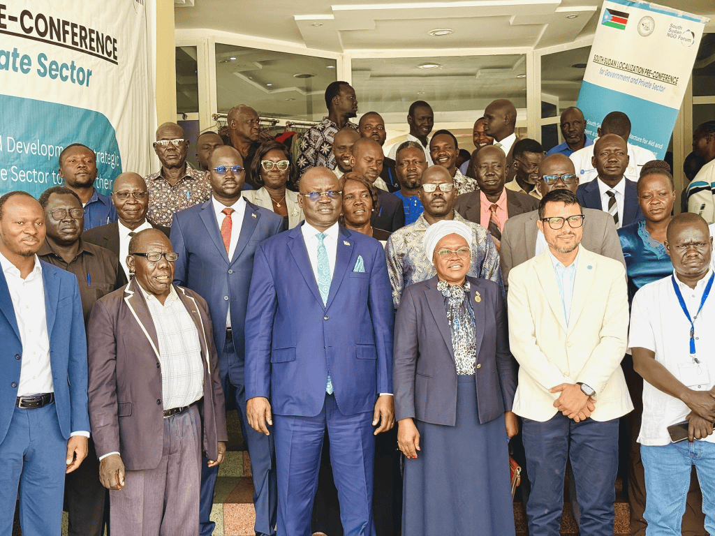
Flood in South Sudan
South Sudan: Floods
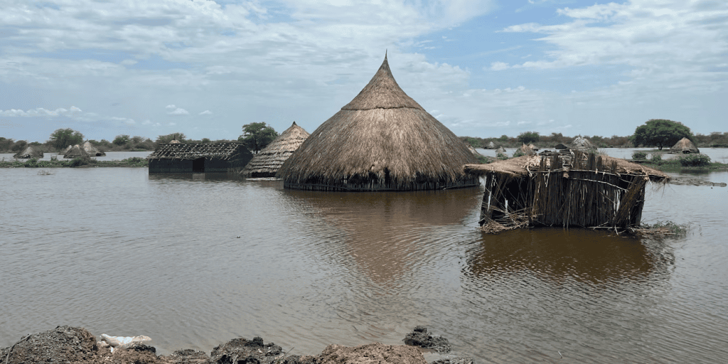
Since May 2024, South Sudan has experienced significant flooding, caused by heavy rainfall and the bursting of the Nile River banks. The floods have affected more than 700,000 people, caused extensive damage to homes and devastated livestock and crops. Through this emergency appeal, the IFRC and its membership aim to address the urgent needs of 300,000 people through health, WASH, shelter and livelihoods interventions.
South Sudan: Floods – Jul 2025
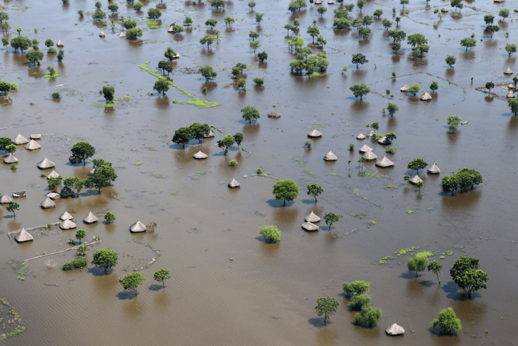
As of 30 July, flooding continues to impact an estimated 80,000 people in Mayendit and Bor South counties, in Unity and Jonglei states. While no flood-related displacement has been reported to date, communities remain at heightened risk due to prolonged exposure to floodwaters. By the end of July, 84,606 confirmed cholera cases and 1,477 related deaths were reported. Stagnant floodwaters, poor sanitation, and limited access to safe drinking water are exacerbating public health risks and increasing the likelihood of further disease outbreaks. Humanitarian partners are closely monitoring the situation and coordinating with health and WASH actors to strengthen disease surveillance, promote hygiene awareness, and address critical water and sanitation gaps. (OCHA, 31 Jul 2025)
Above-normal rainfall is forecast between July and November 2025, with an estimated 1.6 million people at risk of flooding across South Sudan. On 30–31 August, a section of the dyke on the western side of Old Fangak broke overnight, submerging the entire town. As of 1 September, flooding has affected approximately 263,000 people across Unity, Jonglei, and Upper Nile states. On 2 September, the Humanitarian Coordinator with Government led a high-level visit to Malakal, Upper Nile State, to support flood mitigation efforts and engage with communities at risk of flooding and cholera. (ECHO, 4 Sep 2025)
Heavy rainfall and rising water levels of the River Nile continue to inundate multiple areas across the country. As of 9 October, flooding has affected 886,106 people in 26 counties across six states, with Jonglei and Unity accounting for over 91 per cent. Nearly 287,300 people have been displaced across 16 counties, sheltering on higher ground amid widespread damage to homes, farmland, and infrastructure. Of the people affected, 624,289 people are in Jonglei State, about 182,860 people are in Unity State, some 29,374 are in Upper Nile State, about 24,505 are in Central Equatoria State, 14,500 are in Western Equatoria and 10,578 people are in Warrap State. (OCHA, 10 October 2025).