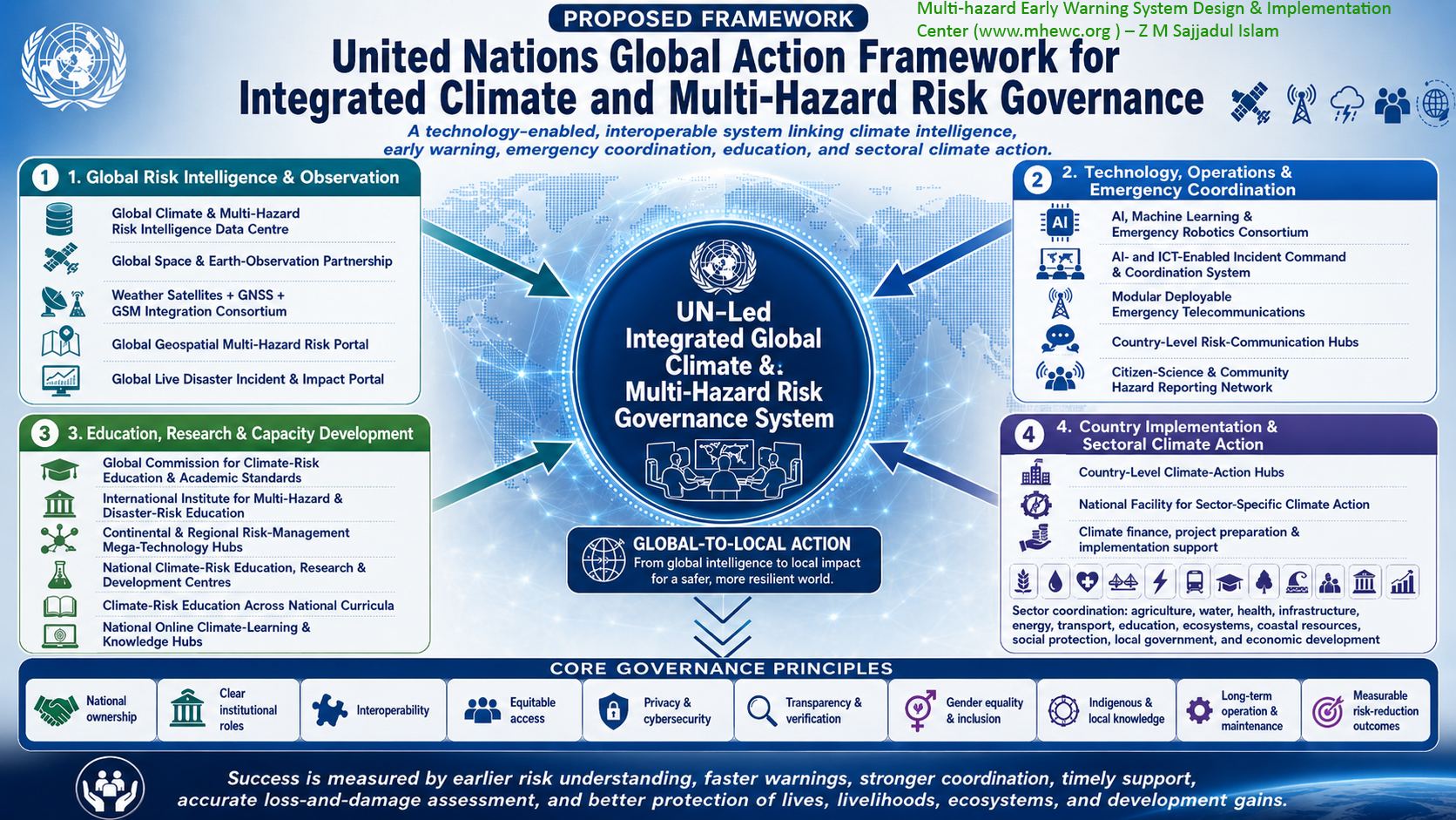
The United Nations and its relevant designated bodies must initiate and support a comprehensive programme for establishing an integrated, technology-enabled global climate and multi-hazard risk governance and management system. The program should move beyond policy advocacy and fragmented projects toward new climate risk intelligence gathering infrastructure development, system installation, networking, data and information maneuverability, coordinated operationalization, capacity development, and long-term maintenance of essential risk-management systems at global, regional, national, and local levels. United Nations must establish a global data center and information hub to integrate all UN-led climate action platforms with a data center for integrated and inclusive climate action decision-making. Working at the request of Member States and in partnership with existing UN agencies, national governments, regional organizations, scientific institutions, space agencies, universities, technology companies, telecommunications operators, civil society, and communities, the United Nations should help countries convert climate and disaster-risk policies into functional operational systems.
The programme should link: Earth observation and ground-based monitoring; climate and multi-hazard risk intelligence; artificial intelligence and geospatial technologies; forecasting and early warning; incident command and emergency telecommunications; anticipatory action and emergency response; disaster-impact and loss-and-damage assessment; education, research, and professional development; community reporting and risk communication; climate finance and investment planning; and monitoring, accountability, and institutional learning.
It is proposed that the United Nations lead and implement the following strategic agenda:
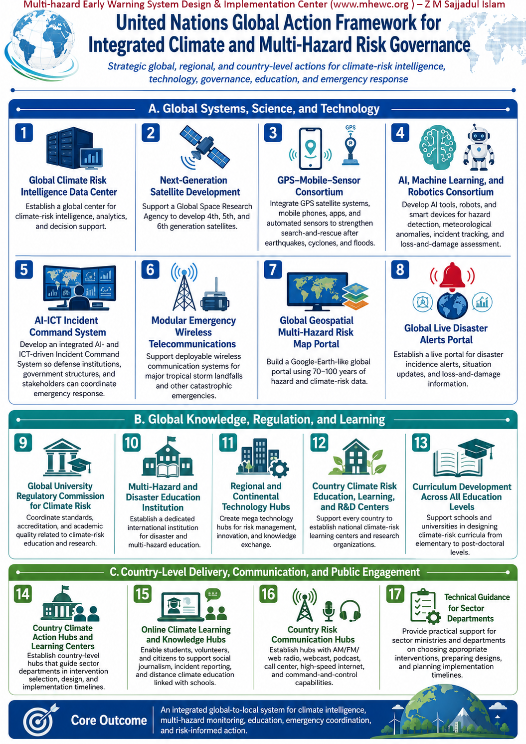
1) The UN should establish a Global Climate and Multi-Hazard Risk Intelligence Data Center
The United Nations should facilitate the establishment of a Global Climate and Multi-Hazard Risk Intelligence Data Center, which would be AI-programmable, cloud-computing, web-to-app linked, machine-learning-based, real-time data ingestion across the globe, satellite-linked, etc., as the central technical backbone of an internationally connected climate-risk governance and decision support system (DSS) (like Google Earth). The proposed giant data center should collect, integrate, analyze, interpret, and disseminate climate, hazard, exposure, vulnerability, impact, capacity, and loss-and-damage information required for global, regional, national, and local decision-making. The center should connect existing international, regional, and national data systems, as mentioned above. The centre should integrate: meteorological, hydrological, oceanographic, geological, and environmental observations; satellite and Earth-observation data; weather forecasts and climate projections; hazard, exposure, vulnerability, capacity, and impact data; population, health, poverty, livelihood, and displacement information; infrastructure, utility, and essential-service data; ecosystem and biodiversity information; historical disaster-loss records; post-disaster needs assessments; loss-and-damage information; community observations and Indigenous and local knowledge; and climate-finance commitments, expenditures, and results. The data center should establish interoperability standards so that country-level AI/GIS/ICT programmer can program themselves, can customize their interface to meet the needs of sector departments, can share classified metadata, metadata protocols, quality-control procedures, secure data-exchange mechanisms, and accessible analytical services. It should produce global and regional risk dashboards, scenario models, seasonal risk outlooks, impact forecasts, and decision-support products for governments, humanitarian organizations, development institutions, businesses, and communities.
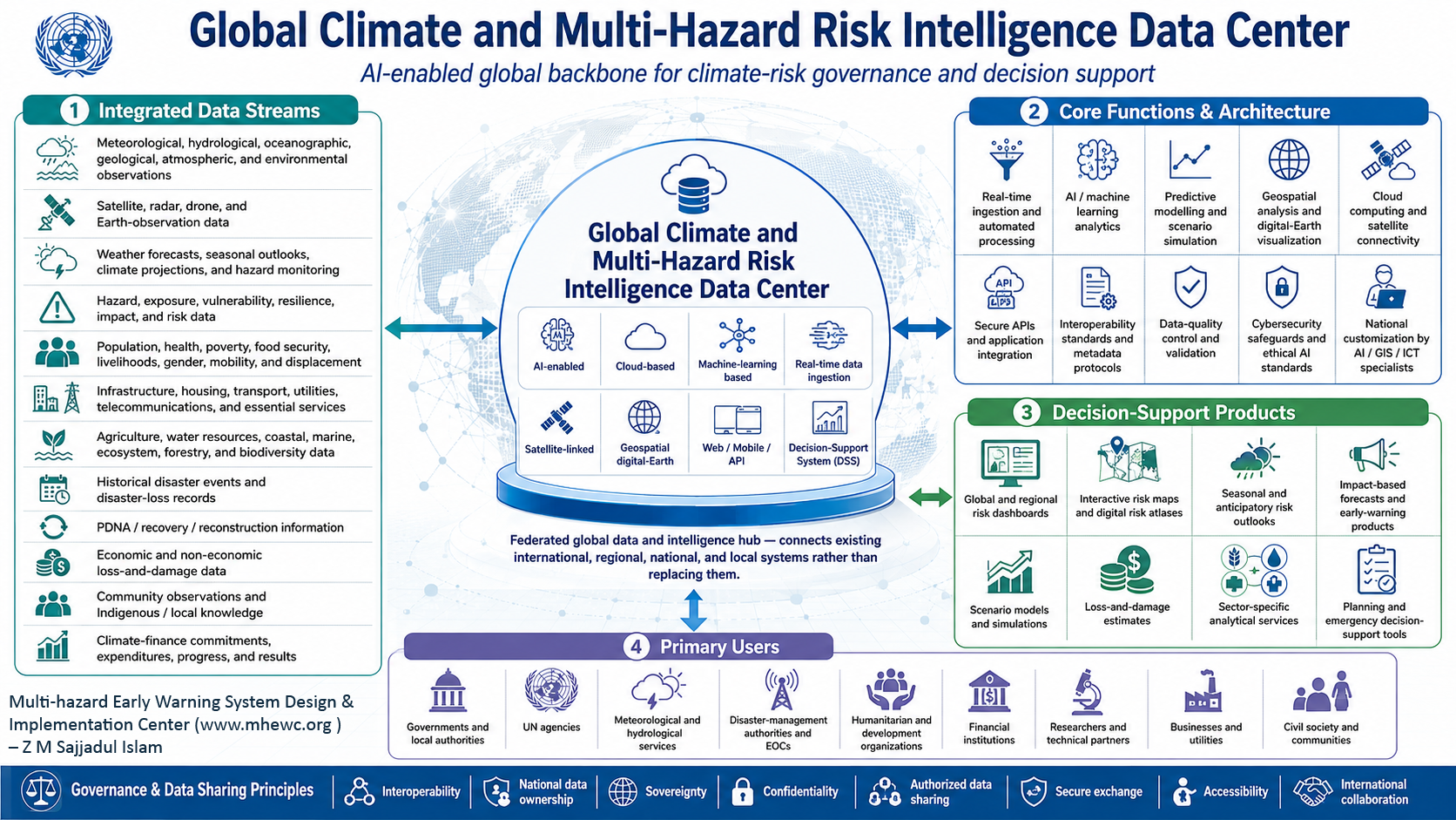
The proposed Global Climate and Multi-Hazard Risk Intelligence Data Center is the central technical backbone of an internationally connected climate-risk governance and decision-support system. The Center should operate as an AI-enabled, programmable, cloud-based, satellite-connected, and geospatially integrated platform capable of continuously ingesting, processing, analyzing, and visualizing real-time data from across the globe. It should provide interoperable web, mobile, and application programming interfaces and an interactive digital-Earth environment comparable in accessibility and functionality to Google Earth.
The Center should collect, integrate, analyze, interpret, and disseminate the climate, hazard, exposure, vulnerability, capacity, impact, and loss-and-damage intelligence required for decision-making at global, regional, national, subnational, and community levels. Its advanced analytical infrastructure should use artificial intelligence, machine learning, geospatial technologies, Earth observation, cloud computing, predictive modelling, and automated data-processing systems to transform diverse datasets into actionable risk intelligence.
Rather than replacing or duplicating existing institutions and platforms, the Center should serve as a federated global hub for data and intelligence. Through secure and specialized APIs, it should connect observation networks, databases, models, analytical platforms, and technical services operated by international, regional, national, and subnational meteorological, hydrological, geological, oceanographic, space, environmental, humanitarian, public-health, and disaster-management institutions.
The Center should integrate tailored datasets from the member states on: Meteorological, hydrological, oceanographic, geological, atmospheric, and environmental observations; Satellite, radar, drone, and other Earth-observation data; Weather forecasts, seasonal outlooks, climate projections, and hazard-monitoring products; Hazard, exposure, vulnerability, coping-capacity, resilience, impact, and risk data; Population, health, poverty, food-security, livelihood, gender, mobility, and displacement information; Infrastructure, housing, transportation, utility, telecommunications, and essential-service data; Agricultural, water-resource, coastal, marine, ecosystem, forestry, and biodiversity information; Historical disaster-event and loss databases; Post-Disaster Needs Assessments and recovery and reconstruction information; Economic and non-economic loss-and-damage data; Community-based observations and Indigenous and local knowledge; and Climate-finance commitments, allocations, expenditures, implementation progress, and measurable results.
The Center should establish common interoperability standards, data classifications, geospatial reference frameworks, metadata protocols, data-quality requirements, cybersecurity safeguards, ethical AI standards, and secure data-exchange mechanisms. These arrangements should respect national data ownership, sovereignty, confidentiality, and access restrictions while enabling authorized data sharing and international collaboration.
Its digital architecture should allow national and subnational AI, GIS, ICT, and data specialists to configure interfaces, develop applications, integrate national datasets, and customize analytical tools according to the operational needs of sector ministries, disaster-management authorities, meteorological and hydrological services, Emergency Operations Centers, humanitarian organizations, and local governments.
The Center should generate interactive global and regional risk maps, real-time risk dashboards, digital risk atlases, scenario and simulation models, seasonal and anticipatory risk outlooks, impact-based forecasts, early-warning products, loss-and-damage estimates, and sector-specific decision-support services. These products should support governments, United Nations agencies, humanitarian and development organizations, financial institutions, researchers, businesses, civil-society organizations, communities, and other stakeholders in undertaking risk-informed planning, anticipatory action, emergency preparedness, climate adaptation, resilient development, and disaster response.
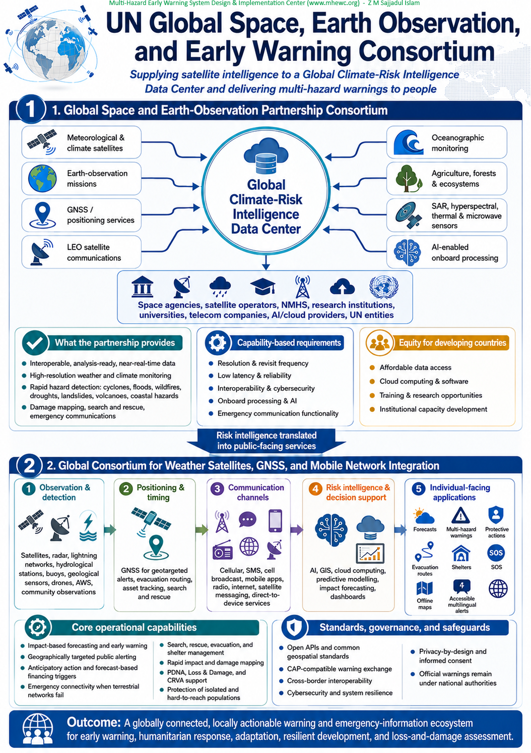
2) The United Nations should support the establishment of a Global Space and Earth Observation Partnership Consortium to supply high-quality datasets to a Global Climate-Risk Intelligence Data Center.
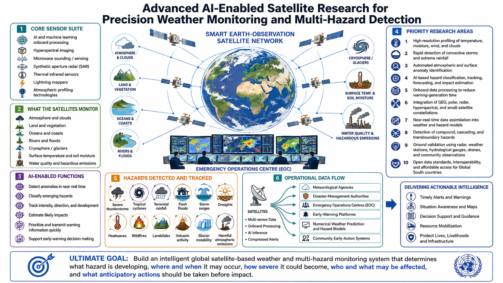
The United Nations should convene a Global Space and Earth-Observation Partnership consortium by involving national space agencies, satellite operators(GPS, Wather/meteriolgoical, hazard detection, environmental monitoring, remote sensing synchronous, oceanographic, Agriculture, LEO data communication, AI-instrumentalized, etc.), research institutions, universities, telecommunications companies, and relevant UN entities to architect this mega project (I am ready to support ). The partnership should provide high-quality, interoperable, analysis-ready, and near-real-time datasets to the proposed Global Climate and Multi-Hazard Risk Intelligence Data Center, able to support the development and application of next-generation satellite capabilities for: high-resolution weather and climate monitoring; rapid observation of cyclones, floods, wildfires, droughts, andslides, volcanic activity, and coastal hazards; atmospheric temperature, humidity, wind, rainfall, and greenhouse-gas measurement; soil-moisture, vegetation, snow, glacier, and water-resource monitoring; ocean temperature, wave, current, sea-level, and storm-surge monitoring; emergency telecommunications; satellite-based positioning and navigation; disaster damage mapping; search-and-rescue support; and continuity of communications where terrestrial systems have failed. Instead of relying on undefined “fourth, fifth, or sixth-generation” labels, the programme should establish capability-based requirements addressing resolution, revisit frequency, latency, reliability, interoperability, onboard processing, artificial intelligence, and emergency communication functionality. Developing countries should receive equitable access to satellite data, processing facilities, analytical software, technical training, and high-performance cloud computing.
The consortium should hold all relevant stakeholders accountable, e,g; national and regional space agencies, satellite owners and operators, National Meteorological and Hydrological Services, Earth-observation and remote-sensing institutions, oceanographic and environmental agencies, agricultural-monitoring organizations, universities, research institutions, telecommunications companies, cloud-computing and artificial-intelligence providers, and relevant United Nations entities to design and operationalize this flagship global initiative.
The Consortium should connect and coordinate satellite systems supporting: Global Navigation Satellite Systems, including positioning, navigation, timing, and emergency-location services; Meteorological and climate observation; Multi-hazard detection and environmental monitoring; Geostationary, polar-orbiting, and other Earth-observation missions; Low-Earth-orbit satellite communications; Oceanographic and coastal monitoring; Agricultural, forestry, ecosystem, and water-resource monitoring; Synthetic Aperture Radar and hyperspectral, multispectral, thermal, microwave, and lightning-observation systems; and AI-enabled instruments and onboard data-processing capabilities. The Consortium should support the research, development, deployment, coordination, and application of next-generation satellite capabilities for: High-resolution and near-real-time weather and climate monitoring; Rapid detection and tracking of cyclones, floods, landslides, wildfires, droughts, volcanic activity, severe storms, coastal hazards, and compound or cascading events; Measurement of atmospheric temperature, humidity, wind, precipitation, aerosols, air quality, and greenhouse gases; Monitoring of soil moisture, vegetation health, crops, forests, snow cover, glaciers, surface water, groundwater indicators, and water resources; Observation of ocean temperature, waves, currents, sea level, coastal change, storm surges, and marine ecosystems; Emergency telecommunications and direct-to-device warning dissemination; Satellite-based positioning, navigation, timing, and geolocation; Rapid disaster-impact and damage mapping; Detection and location of people, vessels, and aircraft requiring emergency assistance; Search-and-rescue planning and operational support; and Continuity of communications when terrestrial infrastructure is damaged, disrupted, overloaded, or unavailable.
The consortium needs to ensure that it conducts comprehensive research and development on “fourth, fifth, or sixth-generation satellites”; the program should establish clear capability-based requirements. These should address spatial, spectral, and temporal resolution; revisit frequency; data latency; geographic coverage; measurement accuracy; reliability; operational continuity; interoperability; cybersecurity; onboard processing; artificial intelligence; automated hazard detection; prioritized data transmission; and emergency-communication functionality.
The Consortium should also establish common technical standards for satellite tasking, sensor calibration, data formats, metadata, quality assurance, secure data exchange, open APIs, cloud-based processing, and integration with national and international decision-support systems. These standards would enable satellite-derived information to flow efficiently into the Global Climate and Multi-Hazard Risk Intelligence Data Center.
Developing countries and climate-vulnerable states should receive equitable and affordable access to satellite data, ground-receiving facilities, high-performance cloud computing, analytical software, AI and geospatial tools, technical training, research opportunities, and institutional capacity development. This would enable them to analyze satellite information independently, develop nationally appropriate applications, and use Earth-observation intelligence for early warning, anticipatory action, climate adaptation, disaster response, resilient development, and loss-and-damage assessment.
I stand ready to contribute my technical knowledge and professional experience in climate-risk assessment, multi-hazard early-warning systems, geospatial technologies, and disaster-risk governance to the design and implementation of this global initiative.
3) The UN should establish a Global Consortium for Weather Satellites, GNSS, and Global Mobile-System(GSM) integration for developing an app-based interface for individuals
The United Nations should establish a Global Consortium to integrate weather satellites, Global Navigation Satellite Systems (GNSS), and mobile communication networks, and to develop user-friendly applications that deliver location-specific weather and multi-hazard early-warning information directly to individuals.
The United Nations should facilitate the establishment of a Global Consortium for integrating weather and Earth-observation satellites, Global Navigation Satellite Systems (GNSS), terrestrial and satellite-enabled mobile communication networks, environmental sensors, geospatial platforms, and emergency applications. The Consortium should develop an interoperable global system capable of delivering location-specific weather information, multi-hazard warnings, emergency instructions, and humanitarian services directly to individuals through accessible, user-friendly applications.
The initiative should function as the public-facing and operational extension of the proposed Global Climate and Multi-Hazard Risk Intelligence Data Center. While the Data Center would integrate and analyze global risk information, the Consortium would help translate that intelligence into timely, understandable, and actionable services for governments, emergency responders, humanitarian organizations, businesses, communities, households, and individuals.
3.a) Proposed institutional composition: The Consortium should bring together: Relevant United Nations organizations; National governments and disaster-management authorities; National Meteorological and Hydrological Services; Geological, oceanographic, environmental, health, and space agencies; Satellite manufacturers, owners, and operators; Global and regional GNSS service providers; Mobile network operators and telecommunications regulators; Smartphone and other connected-device manufacturers; Artificial-intelligence, cloud-computing, geospatial, and software companies; Drone operators and environmental-sensor developers; Search-and-rescue and emergency-response organizations; Humanitarian and development agencies; Universities, technical institutes, and research organizations; Civil-society organizations and organizations of persons with disabilities; and Representatives of vulnerable, remote, Indigenous, and marginalized communities.
These partners should jointly design a globally interoperable but nationally adaptable system. The Consortium should not seek to create a single centralized application for every country. It should establish a common digital architecture, technical standards, APIs, software-development tools, and reference applications that governments and authorized organizations can customize according to their languages, institutions, hazards, laws, communication infrastructure, and community needs.
3.b) Integrated technological architecture :
The Consortium should connect complementary technologies into a unified “system of systems,” including:
- Observation and hazard-detection systems: Weather satellites, Earth-observation satellites, weather radar, lightning-detection networks, hydrological stations, ocean buoys, geological sensors, drones, automated weather stations, environmental sensors, and community-based observation networks.
- Positioning and timing systems: GNSS services should provide precise location, navigation, and timing information for geotargeted warnings, evacuation routing, emergency-vehicle navigation, asset tracking, field assessment, and search-and-rescue operations. GNSS itself should not be treated as a communications system; warning transmission should be provided through mobile, radio, internet, and satellite communication networks.
- Communication systems: Cellular networks, SMS, cell broadcast, mobile applications, radio, internet platforms, satellite communications, direct-to-device satellite services, and emergency communication systems should provide multiple and redundant channels for delivering warnings.
- Risk-intelligence and decision-support systems: Artificial intelligence, machine learning, GIS, cloud computing, predictive modelling, digital mapping, impact forecasting, and operational dashboards should convert raw observations into actionable risk information.
- Individual-facing applications: Mobile and web applications should communicate what hazard is expected, where and when it may occur, its probable severity and impacts, who and what may be affected, and what protective actions people should take before, during, and after the event.
3.c) Core operational capabilities :
The integrated system should support: Multi-hazard detection, monitoring, forecasting, and tracking; High-resolution and location-specific weather forecasting; Impact-based forecasting and early warning; Geographically targeted public alerting; Anticipatory-action and forecast-based financing triggers; Emergency connectivity when terrestrial communication networks fail; Search, rescue, evacuation, and shelter management; Incident command and emergency-response coordination; Tracking of response teams, relief supplies, vehicles, and essential equipment; Rapid disaster-impact and damage mapping; Post-Disaster Needs Assessments; Economic and non-economic loss-and-damage assessments; Climate Risk and Vulnerability Assessments; Recovery, rehabilitation, and reconstruction planning; Humanitarian response planning and logistics mobilization; Monitoring of land degradation, land-use and land-cover change, deforestation and forest degradation; Monitoring of sea-level rise, coastal erosion, glaciers, snow cover, surface-water bodies, drought, vegetation stress, and ecosystem change; and Protection of isolated, marginalized, displaced, and hard-to-reach populations.
3.d) Individual-facing application services
The Consortium should develop a reference application framework through which individuals can receive: Location-specific weather forecasts and multi-hazard warnings; Alert levels expressed through standardized colours, symbols, and plain language; Expected impact, uncertainty, timing, and recommended protective actions; Safe evacuation routes and directions to nearby shelters, hospitals, water points, and emergency services; Offline maps and instructions for areas with weak connectivity; Emergency contact numbers and verified official information; SOS requests and opt-in location sharing with authorized rescue services; Household safety check-ins and missing-person reporting; Information on road closures, damaged bridges, flooded areas, power disruptions, and unavailable services; Public-health, water, sanitation, food-security, and protection advisories; Accessible alerts for persons with visual, hearing, cognitive, mobility, or other disabilities; and Multilingual information adapted to national, local, and Indigenous languages.
Applications should operate effectively on low-cost devices and under low-bandwidth conditions. Critical warnings should not depend exclusively on smartphones or internet connectivity. They should also be disseminated through SMS, cell broadcast, satellite messaging, radio, television, sirens, public-address systems, and trusted community communication networks.
3.e) Humanitarian response and post-disaster applications
During emergencies, the platform should provide authorized responders with a common operational picture showing the hazard area, exposed population, affected infrastructure, evacuation routes, shelters, medical facilities, response teams, available relief supplies, and communication-network status.
Satellite imagery, drone observations, field reports, crowdsourced information, and administrative records should be combined to support rapid assessments of: Affected populations and priority humanitarian needs; Damaged housing, roads, bridges, utilities, hospitals, schools, and communications infrastructure; Crop, livestock, forest, ecosystem, and livelihood losses; Displacement and population movement; Accessibility and logistical constraints; Requirements for food, water, shelter, health care, protection, and sanitation; and Recovery and reconstruction costs and priorities.
Information submitted by individuals should be verified before being used operationally. Artificial intelligence may support detection, prioritization, and analysis, but official warnings and emergency decisions should remain under the authority of legally mandated national institutions.
3.f) Standards and interoperability
The Consortium should establish common standards and protocols covering: Data and metadata formats; Geospatial reference systems and open APIs; Multi-hazard warning terminology and alert levels; Common Alerting Protocol-compatible warning exchange; Geofencing and location-based alert delivery; Integration among satellites, sensors, mobile networks, applications, and government platforms; Data-quality assurance and source verification; Cybersecurity and system resilience; Privacy, consent, and responsible location-data management; Accessibility and multilingual communication; Authentication of official warnings; Cross-border and transboundary information exchange; and Continuity and redundancy during large-scale infrastructure failure.
The system should prevent misinformation, unauthorized alerts, discriminatory surveillance, commercial misuse of personal information, and unnecessary collection of location data. Privacy-by-design, informed consent, limited data retention, encryption, independent oversight, and clearly defined institutional accountability should be incorporated from the beginning.
3.g) Governance and institutional safeguards
The Consortium should complement existing international, regional, and national institutions rather than replacing or weakening their mandates. National Meteorological and Hydrological Services should retain responsibility for authoritative weather and climate information, while legally mandated disaster-management authorities should remain responsible for issuing public warnings and coordinating emergency action.
A UN-facilitated governing council could establish strategic direction, supported by a scientific and technical committee, an operational interoperability group, a data-governance and ethics panel, regional coordination centers, and designated national focal institutions. Governments should retain ownership and control over nationally generated data while participating in agreed arrangements for secure and responsible information exchange.
3.h) Equitable access and capacity development
Developing countries, Small Island Developing States, Least Developed Countries, landlocked countries, and fragile or conflict-affected states should receive equitable access to satellite data, mobile alerting infrastructure, cloud-computing services, analytical software, high-performance computing, technical training, application-development support, and system-maintenance resources.
The Consortium should help national programmers, GIS specialists, meteorologists, disaster managers, and humanitarian organizations customize the platform without rebuilding its core technologies. Open technical standards, reusable software components, regional innovation laboratories, training programmes, and long-term institutional financing should reduce dependency on external consultants and enable sustainable national ownership.
The Consortium would create a globally connected but locally actionable warning and emergency-information ecosystem. By linking satellite observation, precise positioning, mobile communication, artificial intelligence, geospatial analysis, and individual-facing applications, it would help ensure that every person regardless of location, income, language, gender, disability, or connectivity can receive timely risk information and understand what action to take before disaster impacts occur.
The Consortium would bring together UN organizations, national governments, meteorological and hydrological services, space agencies, satellite operators, mobile network operators, handset manufacturers, technology companies, search-and-rescue organizations, universities, research institutions, and humanitarian agencies. Its purpose would be to integrate weather and Earth-observation satellites, Global Navigation Satellite Systems NSS, terrestrial mobile networks, satellite communications, drones, environmental sensors, emergency applications, geospatial platforms and search-and-rescue technologies into a unified global capability for: Multi-hazard detection, monitoring and tracking; Precision weather forecasting and early warning; Location-based public alerting; Emergency connectivity when terrestrial networks fail; Search, rescue and evacuation; Incident and response coordination; Rapid post-disaster mapping; Post-Disaster Needs Assessment DNA; Disaster Loss and Damage assessment; Climate Risk and Vulnerability Assessment CRVA; Tracking land degradation, land cover and land use changes, sea level raise, deforestation and forecast degradation, surface waterbody management and tracking multi-hazard.
The apps are essentially intended to support humanitarian response planning and logistics mobilization; recovery and reconstruction planning; and the Protection of isolated, marginalized, and hard-to-reach populations. The Consortium should complement existing international institutions and technical systems, not replace their mandates. It should provide common standards, a research platform, operational protocols, and an interoperable digital architecture to connect currently fragmented technologies.
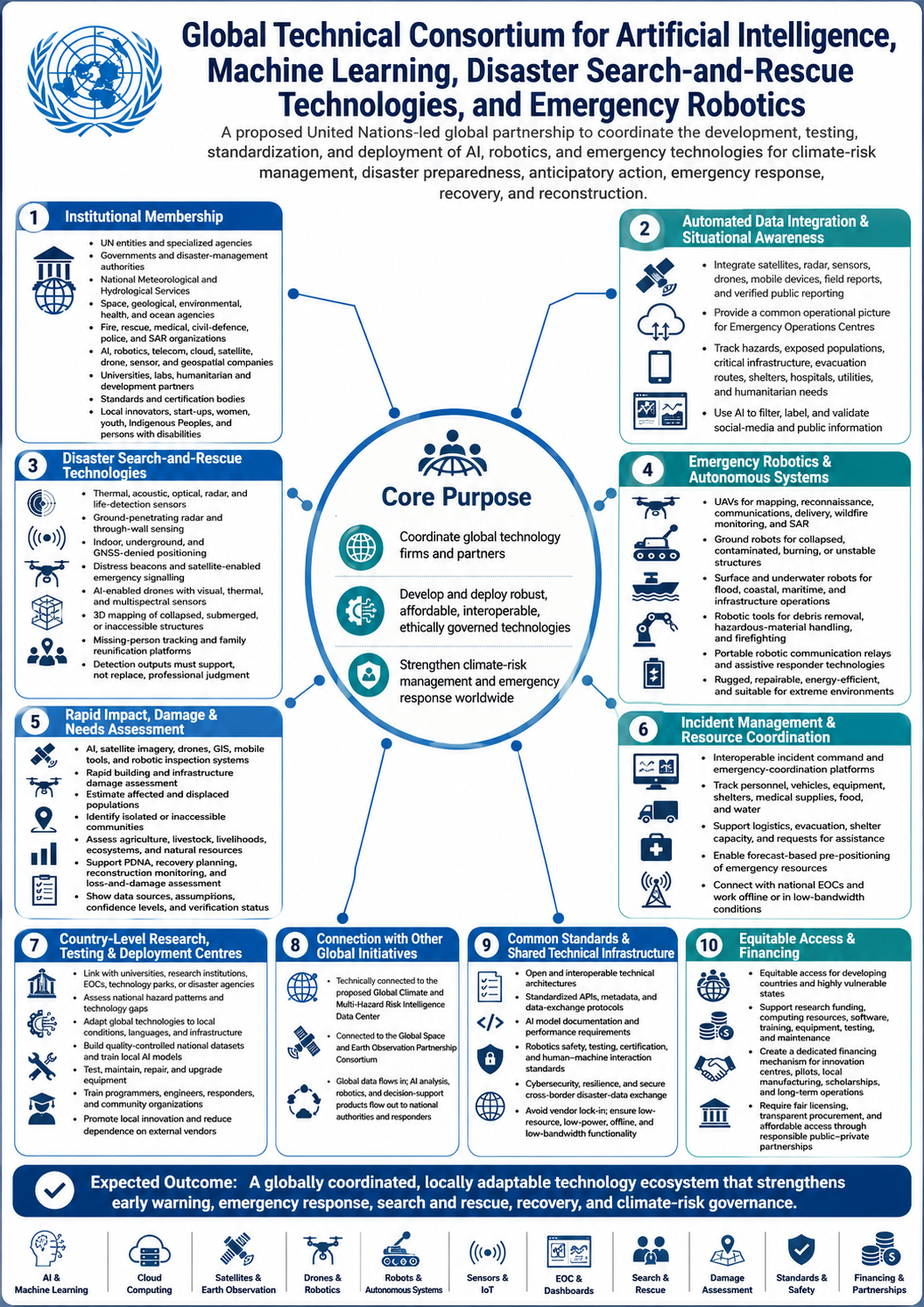
4) The United Nations Should Establish a Global Technical Consortium for Artificial Intelligence, Machine Learning, Disaster Search-and-Rescue Technologies, and Emergency Robotics
The United Nations should establish a Global Technical Consortium to coordinate global tech firms in developing and deploying robust Artificial Intelligence, Machine Learning, Robotics, and Autonomous Systems for Climate and Disaster Risk and emergency response management, disaster search-and-rescue technologies, and emergency robotics Research and Development. The consortium should support the development of: artificial intelligence for detecting atmospheric and surface-level weather anomalies; machine-learning systems for extreme-weather and hazard detection; automated analysis of satellite, radar, sensor, drone, and social-reporting data; impact-based forecasting and probabilistic risk modelling; wildfire, flood, landslide, drought, and coastal-risk detection; AI-assisted disaster-situation reporting; incident and resource-tracking platforms; rapid building and infrastructure damage assessment; automated estimation of affected populations; loss-and-damage data collection and verification; unmanned aerial vehicles for mapping and delivery; ground robots for collapsed-structure search and rescue; aquatic robots for flood and underwater inspection; autonomous environmental monitoring devices; and decision-support tools for emergency operations centres.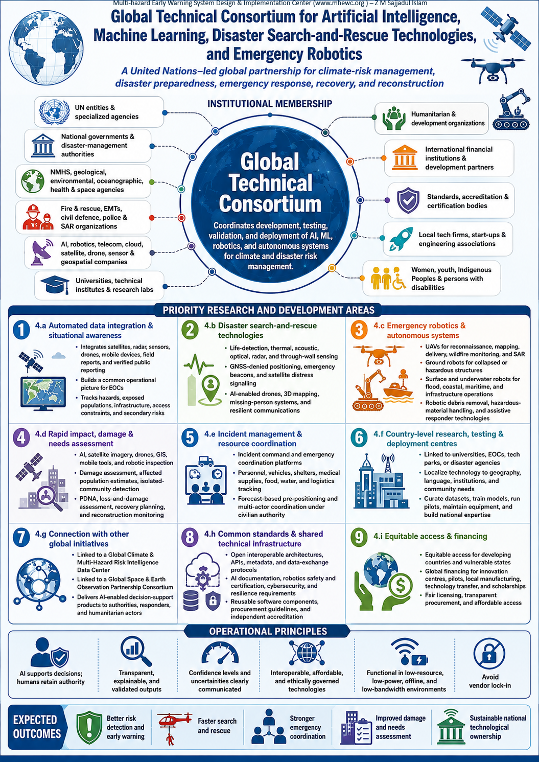
Its other purpose should be to coordinate global technology companies, governments, scientific institutions, humanitarian organizations, emergency responders, universities, and local innovators in developing, testing, validating, and deploying robust, affordable, interoperable, and ethically governed technologies for climate-risk management, disaster preparedness, anticipatory action, emergency response, recovery, and reconstruction.
Institutional membership
The Consortium should coordinate research, development, field testing, standardization, and operational deployment across the following areas.
4.a) Automated data integration and situational awareness
The Consortium should develop systems that combine information from satellites, radar, environmental sensors, drones, mobile devices, official reports, field teams, and appropriately verified public reporting. These systems should provide Emergency Operations Centres with a continuously updated common operational picture covering: Hazard development and projected impact areas; Exposed populations and critical infrastructure; Evacuation routes, shelters, hospitals, and emergency-service facilities; Road, bridge, airport, seaport, power, water, and telecommunications status; Locations of response teams, vehicles, equipment, and relief supplies; Humanitarian needs and access constraints; Displacement and population movement; and Emerging secondary and cascading risks. Develop AI apps for filtering information obtained from social media or unverified public sources and labeling, independently validated.
4.b) Disaster search-and-rescue technologies
The Consortium should promote the research, development, field testing, standardization, and deployment of advanced technologies that enable emergency teams to locate, communicate with, and rescue people affected by earthquakes, collapsed structures, floods, landslides, cyclones, wildfires, maritime emergencies, and other disasters.
Priority technologies should include: Thermal, acoustic, optical, radar, and life-detection sensors; Ground-penetrating radar and through-wall sensing systems; Indoor, underground, and GNSS-denied positioning technologies; Emergency beacons and satellite-enabled distress-signalling systems; AI-enabled drones equipped with visual, thermal, and multispectral sensors; AI-assisted identification of people, movement, heat signatures, voices, and other signs of life; Three-dimensional mapping of collapsed, unstable, submerged, or inaccessible structures; Real-time monitoring of structural stability, environmental hazards, and responder safety; Missing-person registration, identification, tracking, and family-reunification platforms; and Secure and resilient two-way communication systems connecting survivors, field teams, command centres, and emergency services.
Technology-generated findings should serve as decision-support information and should not replace the professional judgment of authorized search-and-rescue personnel. Wherever operational circumstances permit, detection results should be independently verified before high-risk rescue decisions are made. Systems should also clearly communicate their data sources, confidence levels, uncertainties, and possible limitations.
4.c) Emergency robotics and autonomous systems
The Consortium should support the safe development and operational use of: Uncrewed aerial vehicles for reconnaissance, mapping, communications support, emergency delivery, wildfire monitoring, and search and rescue; Ground robots for entering collapsed, contaminated, burning, unstable, or otherwise inaccessible structures; Uncrewed surface vessels for flood, river, coastal, and maritime rescue operations; Underwater robotic vehicles for inspecting submerged infrastructure, dams, bridges, ports, pipelines, and water systems; Robotic equipment for debris removal, hazardous-material handling, firefighting, and infrastructure inspection; Autonomous environmental-monitoring stations; Portable robotic communication relays for areas where terrestrial networks have failed; and Assistive technologies that improve responder safety, mobility, lifting capacity, and operational effectiveness. Emergency robots should be rugged, repairable, energy-efficient, transportable, and suitable for operation in extreme heat, rainfall, dust, smoke, floodwater, debris, and low-connectivity environments.
4.d) Rapid impact, damage, and needs assessment
Artificial intelligence, machine learning, satellite imagery, drones, GIS, mobile assessment tools, and robotic inspection systems should be integrated to support: Rapid building and infrastructure damage assessment; Automated estimation of affected and displaced populations; Identification of inaccessible or isolated communities; Agriculture, livestock, livelihood, ecosystem, and natural-resource loss assessment; Post-Disaster Needs Assessments; Economic and non-economic loss-and-damage assessment; Recovery and reconstruction planning; Monitoring of reconstruction progress; and Verification of reported impacts and assistance delivered. Automated estimates should be transparent about their data sources, assumptions, limitations, confidence levels, and verification status.
4.e) Incident management and resource coordination
The Consortium should develop interoperable platforms for: Incident command and emergency coordination; Deployment and tracking of response personnel; Management of vehicles, equipment, shelters, medical supplies, food, water, and relief materials; Humanitarian logistics and supply-chain planning; Search-and-rescue team coordination; Evacuation and shelter-capacity management; Recording requests for assistance and response status; Forecast-based pre-positioning of emergency resources; and Coordination among government, humanitarian, private-sector, military-support, and community-response actors under civilian authority. These platforms should connect with national Emergency Operations Centres and support offline and low-bandwidth operation during communication disruptions.
4.f) Country-level research, testing, and deployment centres
The global Consortium should be translated into operational capacity through country-level AI, robotics, and emergency-technology centres. Where practical, these centres should be established within or linked to existing universities, research institutions, Emergency Operations Centres, technology parks, or national disaster-management agencies rather than creating unnecessary parallel structures.
Each country-level centre should: Assess national hazard patterns, technology gaps, and operational requirements; Adapt global technologies to local geography, languages, infrastructure, institutions, and community needs; Develop and curate nationally relevant, quality-controlled datasets; Train AI models using representative local data; Test technologies through simulations, field exercises, and controlled operational pilots; Maintain, repair, and upgrade drones, robots, sensors, and communication equipment; Train programmers, engineers, emergency managers, responders, and community organizations; Support universities, start-ups, and local manufacturers in emergency-technology innovation; Develop national operating procedures and technology-deployment protocols; Evaluate system accuracy, reliability, safety, and interoperability; and Connect national systems with regional and global risk-intelligence platforms. Country-level centres should reduce dependence on external consultants and vendors by building sustainable national expertise, maintenance capacity, and technological ownership.
4.g) Connection with other global initiatives
The Consortium should be technically connected to the proposed Global Climate and Multi-Hazard Risk Intelligence Data Center and the Global Space and Earth Observation Partnership Consortium. Satellite, radar, sensor, and environmental data would enter through these global systems, while AI-enabled analysis, search-and-rescue tools, robotics, and operational decision-support products would be delivered to national authorities, Emergency Operations Centres, first responders, and humanitarian organizations.
4.h) Common standards and shared technical infrastructure
The Consortium should establish: Open and interoperable technical architectures; Standardized APIs, metadata, and data-exchange protocols; AI model documentation and performance requirements; Robotics safety, testing, and certification procedures; Human–machine interaction and emergency-operations standards; Cybersecurity and infrastructure-resilience requirements; Secure cross-border disaster-data exchange; Reference software, reusable technical components, and development toolkits; Technology-procurement and lifecycle-maintenance guidelines; and Independent testing and accreditation arrangements. Technologies should be designed to avoid vendor lock-in and remain functional in low-resource, low-power, offline, and low-bandwidth environments.
4.i) Equitable access and financing
The Consortium should support developing countries and highly vulnerable states should receive equitable access to research funding, technical knowledge, computing resources, software, training, equipment, testing facilities, and maintenance support. A dedicated global financing mechanism should support country-level innovation centers, pilot programs, local manufacturing, technology transfer, scholarships, and long-term operational costs. Public–private partnerships should require fair licensing, transparent procurement, responsible intellectual-property arrangements, and affordable access to technologies developed with public or international funding.
5) The UN should support member states in developing AI and ICT-Enabled Disaster Incident Command and Coordination System (ICS)
The United Nations should develop a standardized, interoperable and nationally adaptable AI and ICT-enabled Incident Command, Coordination and Management System unified digital framework through which civilian authorities, emergency services, local governments, defence and security institutions, humanitarian organizations, health services, utility providers, telecommunications operators, volunteers and private-sector actors can coordinate their responsibilities before impending multi-hazard, during & after disaster emergencies. Its institutional and operational architecture should clearly define mandates, command relationships, decision-making authority, reporting lines, information-sharing arrangements and accountability mechanisms across national, provincial, district, municipal and community levels. It should be configurable to each country’s legal framework, institutional structure, hazard profile, administrative system and emergency-management arrangements while maintaining internationally recognized principles of interoperability and information exchange.
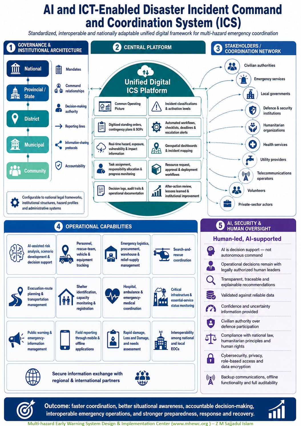
Artificial intelligence should serve strictly as a decision-support capability, not as an autonomous command authority. Responsibility for operational decisions, public warnings, evacuations, resource deployment and security-related actions must remain with legally authorized human decision-makers. AI-generated analyses and recommendations should be transparent, traceable, explainable, validated against reliable data and accompanied by clearly communicated confidence and uncertainty levels.
The United Nations should develop a standardized but nationally adaptable, AI and ICT-enabled Incident Command, Coordination and Management System to help Member States activate, implement, monitor and document disaster-related standing orders, emergency protocols, contingency plans and standard operating procedures. The United Nations should support countries in designing interoperable systems that enable civilian authorities, emergency services, defence and security institutions, local governments, humanitarian organizations, health services, utility providers, telecommunications operators, volunteers and private-sector actors to operate through a unified emergency-management structure. The platform should clearly define institutional mandates, command relationships, decision-making authority, reporting lines, information-sharing protocols and accountability at national and subnational levels.
The system should provide:
A real-time Common Operating Picture; Standardized incident types, classifications and activation levels; Clearly defined command, coordination and reporting arrangements; Digitized standing orders, contingency plans and SOPs; Automated workflow activation, checklists, deadlines and escalation alerts; Real-time hazard, exposure, vulnerability and impact information; AI-assisted risk analysis, scenario development and decision support; Geospatial operational dashboards and incident mapping; Personnel, rescue-team, vehicle and equipment tracking; Task assignment, responsibility allocation and progress monitoring; Resource-request, approval and deployment workflows; Emergency logistics, procurement, warehouse and relief-supply management; Search-and-rescue coordination; Evacuation-route planning and transportation management; Shelter identification, capacity monitoring and registration; Hospital, ambulance and emergency-medical coordination; Critical-infrastructure and essential-service status monitoring; Public-warning and emergency-information management; Field reporting through mobile and offline applications; Rapid damage, Loss and Damage, and needs assessment; Interoperability among national, provincial, district and municipal EOCs; Secure information exchange with regional and international partners; Decision logs, audit trails and operational documentation; and After-action review, lessons learned and institutional improvement.
Artificial intelligence should function as a decision-support capability rather than an autonomous command authority. Operational decisions, public warnings, resource deployments and security-related actions must remain under legally authorized human leadership. AI-generated recommendations should be transparent, traceable, validated against reliable data and accompanied by confidence and uncertainty information.
The participation of defence and security institutions should remain under appropriate civilian authority and comply with national legislation, international humanitarian principles, human rights obligations and clearly defined rules governing command, data access and information security. The system should also incorporate robust cybersecurity, privacy protection, role-based access, data encryption, backup communications, offline functionality and complete auditability to ensure dependable operation during major emergencies.
The United Nations should support countries in designing interoperable, AI- and ICT-enabled Incident Command Systems that enable civilian authorities, emergency services, defence and security institutions, local governments, humanitarian organizations, utility providers, telecommunications operators, health services, volunteers, and private-sector actors to work through a unified emergency-management structure.
The system should provide: a common operating picture; clearly defined command and coordination arrangements; standardized incident classifications; real-time hazard and impact information; personnel, vehicle, equipment, and relief-supply tracking; task assignment and progress monitoring; geospatial operational dashboards; evacuation and shelter-management tools; hospital and emergency-medical coordination; logistics and warehouse management; search-and-rescue coordination; public-information management; damage and needs assessment; interoperability between national and local emergency operations centres; and after-action review and institutional learning.
The participation of defence institutions should remain under appropriate civilian authority and comply with national laws, humanitarian principles, human rights, and clearly defined information-security protocols.
6) The UN should support member states in developing modular, rapidly deployable emergency telecommunications systems to establish resilient risk-communication and operational connectivity in remote, isolated, and hard-to-reach areas.
The United Nations should support the development and pre-positioning of modular, rapidly deployable emergency telecommunications packages for catastrophic cyclones, earthquakes, floods, tsunamis, wildfires, landslides, and compound emergencies. A modular package could include: satellite phones and satellite internet terminals; portable AM, FM, and shortwave radio transmitters; HF, VHF, and UHF radio systems; portable cellular base stations and cells-on-wheels; emergency Wi-Fi and mesh networks; drones or balloons carrying communication relays; solar-powered charging stations; portable generators and battery-storage systems; interoperable emergency frequencies; emergency call-centre equipment; deployable data servers; Common Alerting Protocol systems; and redundant communication links for emergency operations centres.
These systems should be stored in strategically selected locations, regularly tested, maintained, and activated through predefined standard operating procedures. Regional stockpiles should be available where national systems become overwhelmed. The United Nations should support Member States in designing, financing, procuring, pre-positioning, and operating modular, rapidly deployable emergency telecommunications systems. These systems should establish resilient risk communication and operational connectivity in remote, isolated, disaster-affected, and hard-to-reach areas, particularly where conventional telecommunications and electricity infrastructure is unavailable, damaged, congested, or completely disrupted.
The systems should be scalable from compact community-level communication kits to comprehensive national Emergency Operations Center packages and deployable during catastrophic cyclones, earthquakes, floods, tsunamis, landslides, wildfires, volcanic events, severe storms, public-health emergencies, and compound or cascading disasters.
Emergency telecommunications systems should maintain four essential communication flows:
- Authority-to-public communication: Delivering verified warnings, evacuation instructions, safety advisories, and information on shelters and essential services.
- Responder-to-responder communication: Connecting emergency managers, search-and-rescue teams, medical services, firefighters, police, civil-defence personnel, utility providers, humanitarian organizations, and local authorities.
- Community-to-authority communication: Enabling affected people to request assistance, report impacts, share priority needs, and communicate their locations.
- Operational data connectivity: Transmitting situation reports, maps, satellite imagery, drone feeds, weather and sensor data, logistics information, medical records, and resource-tracking information to and from Emergency Operations Centres.
6.a) The proposed modular system components
Each package should be assembled according to the hazard profile, terrain, population distribution, communication coverage, institutional capacity, and operational requirements of the country or deployment area.
Module | Principal components and functions |
Satellite connectivity | Portable geostationary and low-Earth-orbit satellite terminals, satellite phones, broadband satellite internet, emergency beacons, antennas, and satellite-enabled messaging devices |
Emergency radio | Portable AM, FM, and shortwave broadcasting equipment; HF, VHF, and UHF two-way radios; repeaters; radio gateways; and interoperable responder communication systems |
Temporary mobile networks | Portable cellular base stations, cells-on-wheels, compact network cores, rapidly deployable towers, and temporary voice and data services |
Local connectivity | Emergency Wi-Fi, community hotspots, mesh networks, offline local networks, and connectivity for shelters, hospitals, field offices, and response bases |
Airborne communication relays | Drones, tethered balloons, or other aerial platforms carrying temporary radio, mobile, or internet relay equipment |
Public-warning systems | Common Alerting Protocol–compatible systems, cell broadcast, SMS, sirens, public-address equipment, radio interruption systems, and multilingual warning applications |
Command and data systems | Emergency call-centre equipment, rugged laptops and tablets, deployable servers, GIS platforms, offline maps, incident-management software, and local data-storage and backup systems |
Emergency power | Solar-powered charging stations, portable generators, battery-storage systems, power-management equipment, fuel reserves, cables, adaptors, and charging facilities |
Cybersecurity and access control | Encryption, user authentication, device management, network monitoring, secure data exchange, backup procedures, and protection against unauthorized access |
Logistics and maintenance | Rugged transport cases, portable towers, antennas, tools, spare parts, replacement batteries, lighting, weather protection, and equipment inventories |
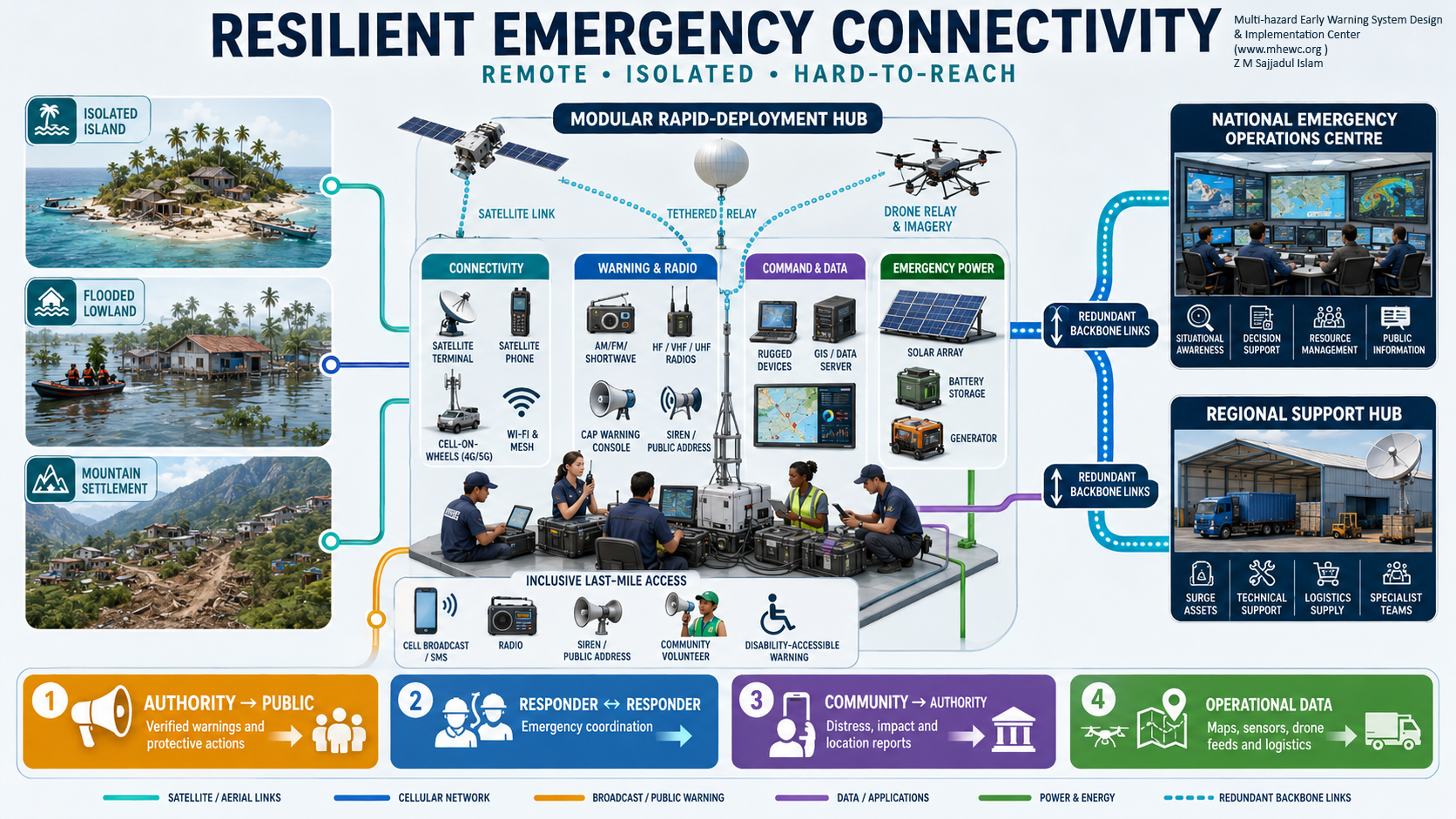
Once deployed, the system should support: Dissemination of authoritative multi-hazard warnings and emergency instructions; Coordination among national, provincial, district, municipal, and community authorities; Communication among search-and-rescue, medical, fire, security, utility, and humanitarian teams; Emergency calls, distress messages, missing-person reports, and family-reunification services; Telemedicine and communication between field medical teams and referral hospitals; Transmission of satellite imagery, drone observations, damage maps, and field-assessment data; Tracking of emergency personnel, vehicles, equipment, relief supplies, and evacuation movements; Coordination of food, water, shelter, health, protection, sanitation, and logistics services; Continuity of government and essential public services; Communication with remote communities, islands, mountainous areas, border regions, and displaced populations; and Restoration of basic public connectivity while permanent telecommunications networks are repaired.
6.b) Pre-positioning and regional stockpiles
Emergency telecommunications packages should be stored in strategically selected, hazard-informed locations that are secure, accessible, and sufficiently separated from major risk zones. National stockpiles should be positioned near transport hubs, Emergency Operations Centres, civil-defence facilities, airports, seaports, and regional response bases.
Regional stockpiles should also be established to provide surge support when national capacity is overwhelmed or multiple countries are affected simultaneously. These regional facilities should maintain: Ready-to-deploy equipment packages of different sizes; Trained emergency telecommunications teams; Standby transport and logistics arrangements; Updated equipment inventories and deployment records; Pre-negotiated customs and cross-border movement procedures; Agreements for temporary spectrum use and satellite-service activation; Spare parts, replacement batteries, fuel, and repair facilities; and Arrangements for equipment replenishment following deployment. Stockpiles should be designed around regional hazard patterns and should avoid being concentrated in locations exposed to the same catastrophic event.
6.c) Activation and deployment procedures
Every package should be governed by predefined standard operating procedures covering: Activation thresholds and authorized decision-makers; Rapid assessment of communication damage and operational requirements; Selection of the appropriate equipment modules; Release, transport, customs clearance, and delivery arrangements; Spectrum authorization and coordination with telecommunications regulators; Installation, testing, and connection to Emergency Operations Centres; User authentication and prioritization of emergency traffic; Technical support, maintenance, and cybersecurity monitoring; Handover to national or local institutions; Demobilization, inspection, repair, and restocking; and Post-deployment evaluation and documentation of lessons learned. Equipment should be capable of being transported by road, air, sea, small boats, or helicopters and installed by trained teams within clearly defined operational timeframes.
6.d) Interoperability and common standards
The United Nations should support common technical standards that allow equipment from different countries, organizations, and manufacturers to work together. These standards should cover: Radio and telecommunications interoperability; Common Alerting Protocol implementation; Open APIs and standardized data formats; Connection with national early-warning systems and Emergency Operations Centres; Cross-network communication gateways; Priority access and traffic management for emergency users; Pre-authorized national and regional emergency-frequency arrangements; Multilingual and disability-accessible warning formats; Cybersecurity, encryption, authentication, and data protection; Equipment durability, power efficiency, and environmental resistance; and Operation under low-bandwidth, intermittent, and offline conditions. The system should remain technology-neutral and avoid dependence on a single vendor, satellite operator, mobile network, or communication channel. Multiple redundant pathways should be maintained so that the failure of one system does not interrupt critical communication.
National disaster-management authorities should lead activation and operational coordination in accordance with national law. Telecommunications regulators should authorize spectrum use, while mobile network operators, broadcasters, satellite providers, utilities, emergency services, humanitarian organizations, and local governments should have clearly defined responsibilities.
The systems should integrate with nationally established Incident Command and Emergency Operations Centre arrangements. The United Nations should provide technical assistance, facilitate international interoperability, coordinate regional surge capacity, and support countries whose systems have been overwhelmed. These arrangements should strengthen, not replace, existing national institutions and international emergency-telecommunications mechanisms.
6.e) Inclusive last-mile communication
Emergency information should reach everyone, including people without smartphones, internet access, formal identification, or literacy. Warning and communication arrangements should therefore combine digital platforms with radio, sirens, public-address systems, community volunteers, local organizations, religious institutions, schools, health facilities, and traditional communication networks.
Messages should be multilingual, concise, accessible to persons with disabilities, and designed around the questions people need answered: What is happening? Where and when will it occur? How severe could it be? Who and what may be affected? What action should people take?
The United Nations should also facilitate advance agreements with satellite companies, telecommunications operators, equipment manufacturers, logistics providers, and energy companies to ensure rapid activation, affordable emergency services, technical support, and predictable replacement of damaged equipment.
7) Establish a Global Geospatial Multi-Hazard Risk Portal ( like Google Earth)
The United Nations should facilitate an interactive Global Geospatial Multi-Hazard Risk Portal with functionality comparable to widely used digital-Earth platforms, while focusing specifically on climate, disaster, vulnerability, exposure, and resilience information. Where reliable data exist, the portal should incorporate historical records covering approximately 50/70/100 years, while clearly documenting data gaps and uncertainties. It should provide: historical hazard footprints; disaster-event timelines; flood, cyclone, drought, wildfire, earthquake, landslide, tsunami, heatwave, and coastal-risk layers; climate trends and projected scenarios; exposed populations and settlements; critical infrastructure and essential services; agricultural, water, ecosystem, and livelihood information; vulnerability and coping-capacity indicators; evacuation routes, shelters, hospitals, and emergency facilities; historical impacts, losses, and damages; future risk scenarios; and downloadable data and analytical tools.
Different access levels may be required to protect personal information, critical infrastructure, national security, and sensitive community data. Public information should nevertheless remain accessible, understandable, and usable by schools, researchers, planners, businesses, civil society, and communities.
8) The UN should support developing a Global and Country-level Live Disaster Incident and Impact Portal
A Global Live Disaster Incident, Impact and Loss-and-Damage Portal should provide continuously updated information on major emergencies. It should display: incident location, type, severity, and status; observed and forecast hazard conditions; affected and at-risk areas; casualties, displacement, and affected populations; damage to housing and critical infrastructure; disruption of health, education, water, power, transport, and telecommunications; agricultural, livelihood, and ecosystem impacts; response activities and unmet needs; humanitarian-access constraints; provisional estimates of economic and non-economic loss and damage; and sources, verification status, confidence level, and time of update.
The portal must clearly distinguish between preliminary reports, modeled estimates, verified government figures, and independently validated assessments. This is essential to prevent misinformation and double-counting during fast-moving emergencies.
9)Establish a Global Commission for Climate-Risk Education and Academic Standards
Because education regulation remains primarily a national responsibility, the United Nations should establish a Global Commission for Climate-Risk Education, Qualifications and Academic Standards rather than a supranational university regulator.
In cooperation with national accreditation authorities, universities, professional associations, and technical institutions, the commission should: develop international competency frameworks; recommend minimum academic and training standards; support recognition of climate-risk qualifications; facilitate academic credit transfer and professional mobility; develop ethical standards for climate-risk professionals; review emerging technical skills and occupational requirements; promote quality assurance in climate and disaster education; support professional certification and continuing education; and maintain a global directory of recognized programmes and centres of excellence.
10) Establish an International Institute for Multi-Hazard and Disaster-Risk Education
An International Institute for Climate, Multi-Hazard and Disaster-Risk Education should offer specialized academic, professional, executive, and field-based training. Its programmes should cover: climate science and multi-hazard risk assessment; meteorology, hydrology, oceanography, and geospatial science; early warning and impact-based forecasting; emergency operations and incident command; humanitarian logistics and anticipatory action; resilient infrastructure and urban planning; climate finance and disaster-risk financing; loss-and-damage assessment; public health and climate-related disease risks; ecosystem-based adaptation; risk communication; humanitarian protection and inclusion; and artificial intelligence and emerging technologies.
The institute should operate through regional campuses, affiliated universities, online platforms, field laboratories, and professional-exchange programmes.
11) Establish Continental and Regional Risk-Management Mega Technology Hubs
Regional mega-technology hubs should give countries shared access to advanced systems that may be too expensive or technically demanding to establish independently. The hubs should provide: high-performance computing; numerical weather and climate modeling; hydrological, hydraulic, coastal, wildfire, and landslide modeling; satellite-data receiving and processing; artificial-intelligence laboratories; geospatial analysis and digital-twin development; drone and robotic-system testing; sensor calibration and equipment repair; cybersecurity and data-backup services; technology demonstrations and training; innovation and start-up incubation; and technical surge support during emergencies.
They should also promote regional manufacturing, assembly, maintenance, and adaptation of technologies to local environmental and operational conditions.
12) Establish National Climate-Risk Education, Research and Development Centres
Every country should be assisted in establishing or designating a National Climate-Risk Education, Learning, Innovation and Research Centre. Existing universities and technical institutions should be strengthened wherever possible. The centre should: conduct country-specific climate and multi-hazard research; translate global science into national and local applications; develop locally appropriate technologies and methodologies; maintain national research and knowledge repositories; evaluate climate and risk-reduction programmes; support government institutions with technical analysis; provide training to local governments and communities; document Indigenous and local knowledge; facilitate partnerships among universities, industries, and government; and support young researchers, women scientists, innovators, and entrepreneurs.
13) Integrate Climate-Risk Education throughout National Curricula
The United Nations should assist education ministries, national curriculum authorities, universities, and training institutions in integrating climate and multi-hazard risk education at: elementary level; secondary level; higher-secondary level; technical and vocational level; undergraduate level; graduate and postgraduate levels; doctoral and postdoctoral levels; and continuing professional-development level. Content should be age-appropriate, scientifically sound, locally relevant, action-oriented, and connected to the hazards, ecosystems, livelihoods, and social conditions of each country. Climate-risk learning should also be integrated into engineering, architecture, agriculture, medicine, economics, finance, law, public administration, education, journalism, information technology, social sciences, and development studies.
14) Establish every country-Level Climate-Action Hubs
Country-level Climate-Action and Climate-De-Risking Hubs should help governments convert policies and plans into coordinated investment and implementation programmes. Each hub should: maintain a national climate and multi-hazard risk picture; coordinate ministries, technical agencies, and local governments; review sectoral risks and institutional capacity; identify appropriate risk-reduction interventions; prioritize interventions according to urgency and expected benefits; develop implementation timelines and institutional responsibilities; prepare costed project pipelines; connect proposals with financing opportunities; monitor implementation and outcomes; and identify gaps requiring international assistance. The hub should strengthen, not replace, the authority of existing government institutions.
15) Establish National Online Climate-Learning and Knowledge Hubs
The United Nations should support every Member State in establishing an accessible, inclusive, and nationally owned online learning platform for climate change, environmental protection, disaster risk reduction, and emergency preparedness. The platform should serve students, teachers, volunteers, journalists, professionals, researchers, local government officials, community leaders, and the general public. The platform should provide: Age-appropriate climate and disaster-risk education; Teacher-training materials and instructional guidance; Live and recorded virtual classes; Localized hazard maps, risk profiles and case studies; Interactive simulations, exercises, quizzes and educational games; Volunteer preparedness and emergency-response training; Verified citizen-observation and incident-reporting tools; Household and community preparedness guidance; Professional development and certification courses; Open-access research, policy documents and technical resources; Materials adapted for persons with disabilities; Learning content in national and local languages; and Dedicated resources addressing the needs of vulnerable and hazard-exposed communities.
Schools, colleges, libraries and community centers could affiliate with the platform as supported climate-learning and distance-education centers. These institutions could provide facilitated sessions, internet access, shared digital devices, teacher support and locally relevant practical activities. Online education should complement, not replace, classroom teaching and community-based learning. The system must not exclude learners without reliable internet access, electricity or personal digital devices. Educational content should therefore also be distributed through radio, television, mobile phones, downloadable modules, memory cards, printed materials and offline learning packages.
The platform should incorporate low-bandwidth access, offline functionality, accessible formats and multiple dissemination channels to ensure that climate and disaster-risk knowledge reaches learners in remote, marginalized and hard-to-reach communities. Universities, scientific institutions, civil society organizations, media organizations, and private technology companies should be encouraged to contribute verified educational content while maintaining national quality assurance and accreditation standards.
16) Establish a National Citizen-Science and Community-Based Hazard Reporting Network
A structured citizen-science and trained-volunteer network should enable individuals and communities to contribute to environmental monitoring, social journalism, early warning, and disaster-situation reporting. Participants could report: rainfall and water levels; heat, drought, wildfire, and landslide indicators; coastal and river erosion; damage to infrastructure; disruption of essential services; localized disaster impacts; unmet humanitarian needs; and ecosystem and livelihood changes. Reports should be geotagged, time-stamped, moderated, and verified before being presented as official information. Contributors should receive training on safety, ethics, privacy, misinformation prevention, humanitarian protection, and responsible risk communication.
With support from the United Nations, Member States should establish an inclusive, nationally coordinated, and locally operated Citizen-Science and Community-Based Hazard Reporting Network (CAP Development) . The Network should enable trained individuals and community organizations to contribute safely and systematically to environmental monitoring, early warning, public-interest reporting, disaster-situation awareness, humanitarian needs assessment, and post-disaster recovery monitoring.
The Network should complement, not replace, official observation systems, National Meteorological and Hydrological Services, disaster-management authorities, emergency responders, scientific institutions, or professional assessment processes. Its role should be to fill local observation gaps, provide ground-level information, verify remote-sensing products, identify emerging impacts, and strengthen communication between communities and responsible authorities.
16.a) Objectives of the Network (Automated sensor ingested data gathering )
The Network should install real-time data gathering and event situation updates from the field level to have the event situation update. Expand environmental and hazard monitoring into underserved and hard-to-reach locations; Detect localized hazards and changing environmental conditions; provide ground-truth information for satellite, radar, modelled, and sensor-based products; Report disaster impacts and disruptions to essential services; Identify unmet humanitarian and protection needs; Monitor whether warnings have reached communities and prompted appropriate action; Strengthen two-way communication between communities and government institutions; Document ecosystem, livelihood, and climate-related changes; and Build public understanding of hazards, early warning, climate risks, and preparedness.
The Network should bring together community volunteers, local disaster-management committees, farmers, fishers, pastoralists, forestry workers, health workers, teachers, students, universities, women’s and youth organizations, Indigenous knowledge holders, organizations of persons with disabilities, local media, civil-society organizations, humanitarian volunteers, professional associations, and local-government representatives. Participation should be voluntary, inclusive, properly supervised, and based on clearly defined roles. Community observers should not be treated as emergency responders or instructed to enter hazardous areas unless they are formally trained, equipped, insured, and authorized to perform such duties.
17) Establish Country-Level Risk-Communication Hubs
Country-level Risk-Communication Hubs should provide redundant, inclusive, multilingual, and round-the-clock public-warning and emergency-information services.
Each hub should be equipped with: terrestrial AM, FM, and shortwave radio capability; internet radio and live webcasting; television and online video broadcasting; podcasts and recorded public-information services; high-speed and backup internet connections; satellite communication; cell broadcast and location-based alerts; SMS, mobile applications, and social-media dissemination; Common Alerting Protocol technology; an emergency call centre; accessible services for persons with disabilities; rumor monitoring and misinformation management; a media coordination facility; and a command-and-control room linked to national and local emergency operations centres. Warnings should be delivered in clear language and include the expected hazard, affected location, timing, severity, likely impacts, and specific protective actions.
18) Establish a National Facility for the Design, Financing, Coordination, and Implementation of Sector-Specific Climate Action.
A dedicated technical facility should help sector ministries and departments identify, design, prioritize, finance, and implement appropriate climate-risk interventions. The facility should support agriculture, water, health, infrastructure, energy, transport, settlements, education, ecosystems, coastal resources, social protection, local government, and economic-development institutions.
Its services should include: sector risk and institutional-capacity assessments; identification and comparison of intervention options; feasibility and cost-benefit analysis; maladaptation and environmental-safeguard screening; preparation of technical designs, budgets implementation timelines; assignment of institutional responsibilities; procurement and technology-selection support; development of financing proposals; results frameworks and performance indicators; monitoring, evaluation, accountability, and learning; and scaling of interventions proven to be effective.
The Facility should provide integrated technical and project-preparation support to institutions responsible for: Agriculture, food security, livestock and fisheries; Water resources, sanitation and irrigation; Public health and nutrition; Infrastructure, housing and human settlements; Energy and telecommunications; Transport and logistics; Education and research; Forests, biodiversity and ecosystems; Coastal and marine resources; Social protection and humanitarian assistance; Local government and urban development; and Industry, trade, tourism and wider economic development. Its support should ensure that sectoral interventions are evidence-based, technically feasible, financially viable, environmentally sustainable, socially inclusive and aligned with national climate commitments, development priorities and disaster-risk-reduction strategies.
The entire system should be governed by: respect for national sovereignty and national ownership; clear division of responsibilities among institutions; avoidance of unnecessary institutional duplication; open and interoperable technical standards; equitable access to data, technology, finance, and education; protection of privacy, data sovereignty, and cybersecurity; transparency and independent verification; civilian oversight of emergency-management systems; gender equality, disability inclusion, and social protection; recognition of Indigenous and local knowledge; long-term operation and maintenance planning; environmental sustainability and responsible technology use; and accountability for measurable risk-reduction outcomes.
The success of this United Nations–led initiative should ultimately be measured not by the number of platforms created or technologies installed, but by whether risks are understood earlier, warnings reach people faster, institutions act more effectively, communities receive timely support, emergency services remain connected, losses and damage are accurately assessed, and lives, livelihoods, ecosystems, and development gains are protected.
This proposal is protected by copyright. © 2026 Z M Sajjadul Islam, Advisor, Multi-Hazard Early Warning System Design and Implementation Center (MHEWC). All rights reserved. Any material quoted, reproduced, adapted, or extracted from this proposal must be properly cited and attributed to the author.
……………………………………………………………………………………………………………………………………………………….