AI and machine learning-enabled automated multi-hazard early warning sytem(EWS) architecture (Draft)
The copyright © 2026 Z M Sajjadul Islam, Advisor, Multi-Hazard Early Warning System Design and Implementation Center (MHEWC : www.mhewc.org & https://glocs.org/ ). All rights reserved. Any material quoted, reproduced, adapted, or extracted from this proposal must be properly cited and attributed to the author. Please call at +8801711979179, Email: zmsajjad@gmail.com
Background :
Considering the increasing speed, complexity, and unpredictability of changing weather conditions and meteorological phenomena, many hazardous events are now developing with very short lead times and, in some cases, with sudden onset. Recent experiences with localized microclimatic anomalies and variability, rapidly intensifying thunderstorms, cloudbursts, extreme rainfall, flash flooding, and other extremely damaging high-impact hydrometeorological events are creating significant operational challenges for national meteorological agencies, National Meteorological and Hydrological Services (NMHSs), and national disaster management organizations (NDMOs).
These erratic weather patterns indicate that conventional forecasting and warning approaches alone may no longer be sufficient to meet the demands of increasingly rapidly evolving hazards. A major transition is therefore required toward more highly instrumented, integrated, AI- and machine-learning-data-driven, and automated forecasting and warning systems. This transition should include strengthened atmospheric and surface observation networks, high-resolution numerical weather prediction(NWP), real-time data assimilation & NWP automation, AI and machine-learning-supported hazard detection, automated threshold recognition, automated impact-based forecasting, automated multi-hazard triggers and threshold-guided warning-level determination, automated Common Alerting Protocol (CAP) generation, and rapid multi-channel transmission and broadcasting of authoritative warnings to end-users and populations at risk. So that any automated observation, automated monitoring, automated detection, automated NWP prediction, and automated multi-channel broadcasts can happen round the clock; otherwise, the impacts, losses, and damages cannot be minimized, and they require highly prioritized investment for system deployment.
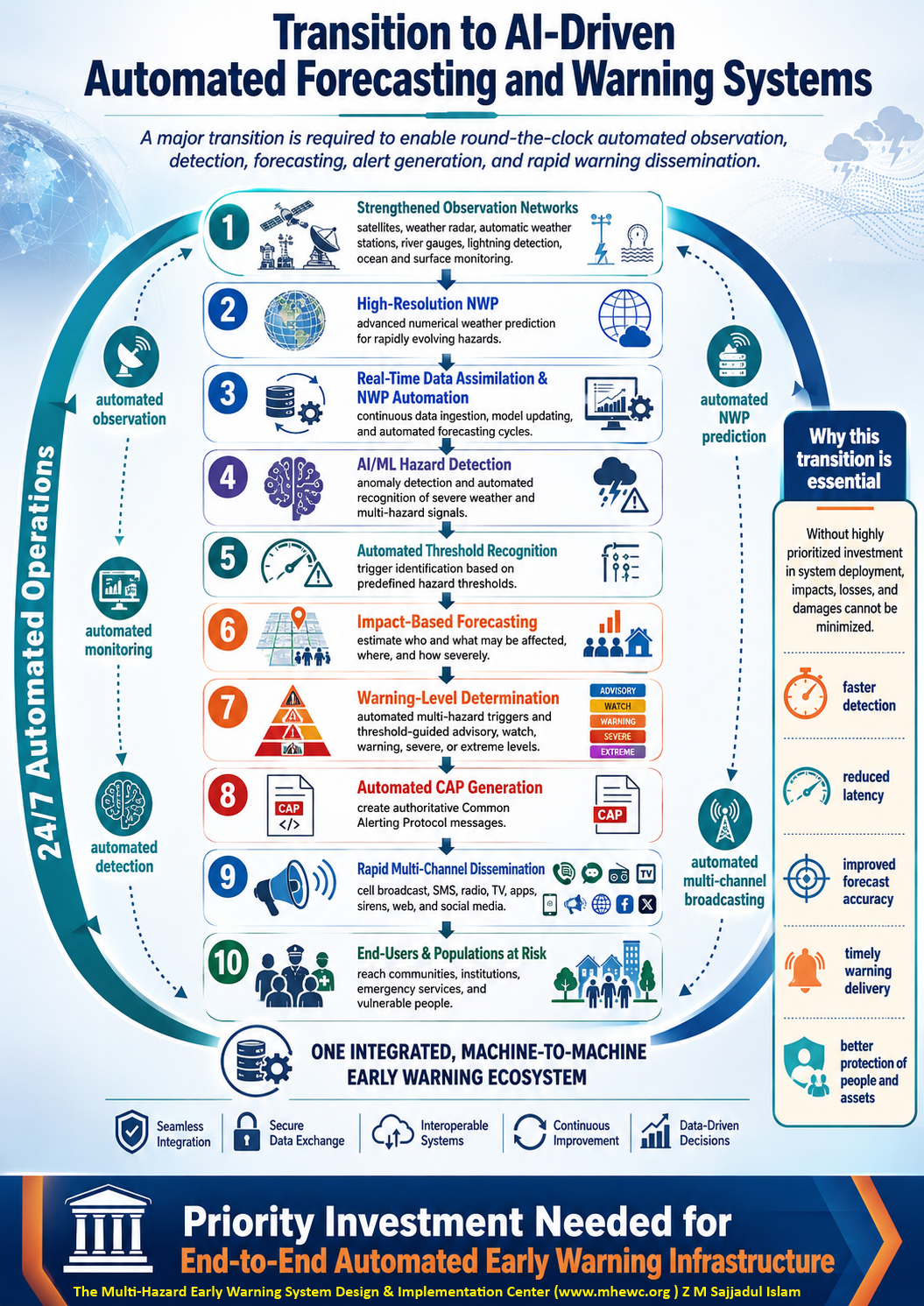
Recognizing the scale of this technological and operational paradigm shift, the Multi-Hazard Early Warning System Design and Implementation Center (MHEWC) encourages international meteorological centers, Data Collection or Production Centers (DCPCs), WMO Information System (WIS) stakeholders, Regional Specialized Meteorological Centers (RSMCs), NMHSs, universities, research institutions, technology developers, and other technical partners to intensify collaborative research, development, testing, and operational innovation.
Priority research and development should focus on establishing robust and interoperable systems for atmospheric and surface observation, real-time event and situation-data collection, high-resolution forecasting, rapid hazard identification, impact modeling, warning-threshold determination, CAP trigger generation, geographic targeting, automated dissemination, and continuous situation monitoring and alert updating.
The ultimate objective should be to move toward an integrated, machine-to-machine early warning architecture in which observations, forecasts, impact assessments, warning decisions, CAP alerts, and dissemination platforms operate as a synchronized end-to-end system. Such an approach could substantially reduce warning-generation latency, improve 24/7 operational continuity, and enable rapidly developing hazardous events to trigger timely, location-specific, actionable warnings even when conventional manual decision-making processes cannot respond quickly enough.
Introduction:
Intensive research and development are required to install and operationalize an AI and machine learning-enabled automated multi-hazard early warning architecture; advanced research and development of an AI and machine-learning-enabled automated Multi-hazard early warning architecture designed to accelerate hazard detection, impact forecasting, alert generation, and last-mile dissemination across the entire warning value chain.
The proposed automated system will continuously ingest and analyze Essential Climate Variables (ECVs) and other real-time Earth observation, meteorological, hydrological, oceanographic, environmental, geospatial, and ground-based monitoring data. These data streams may include satellite observations, weather radar, automatic weather stations, river and rainfall gauges, lightning detection networks, ocean buoys, IoT sensors, remote-sensing products, numerical weather prediction outputs, and verified community-level observations.
Using artificial intelligence, machine learning, anomaly detection algorithms, and predefined hazard trigger thresholds, the system will automatically identify unusual or rapidly evolving conditions that may indicate the onset or escalation of hazards such as floods, flash floods, cyclones, severe storms, extreme rainfall, droughts, heatwaves, landslides, wildfires, coastal inundation, and other climate and weather-related emergencies.
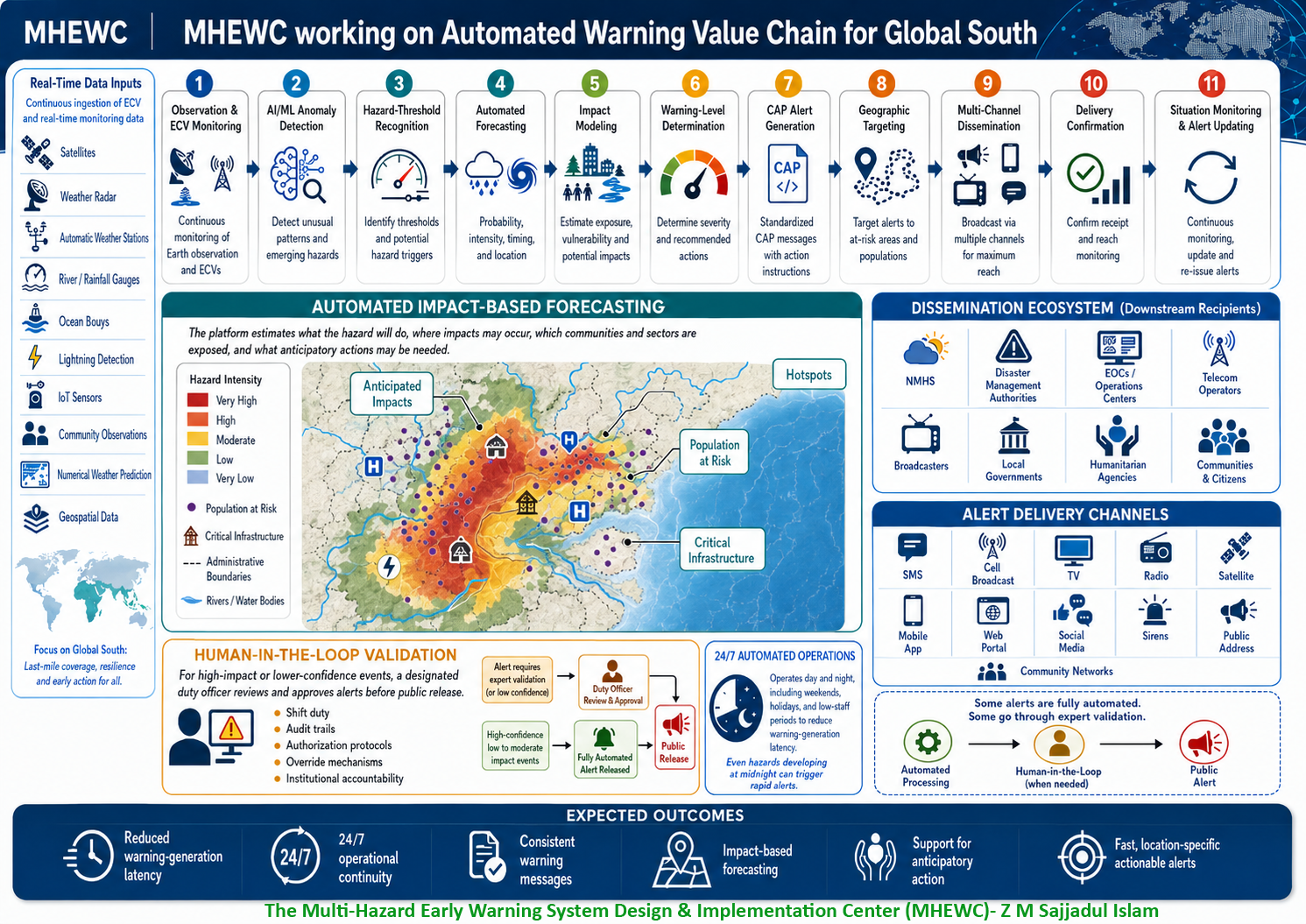
Once a hazard threshold or combination of thresholds is exceeded, the automated platform will assess the probability, intensity, spatial extent, expected timing, impact figures, and potential evolution of the event. It will then integrate hazard-induced anticipatory impact indicators with exposure, vulnerability, population, infrastructure, livelihood, and critical facility datasets to generate automated impact-based forecasts. Rather than communicating only the physical characteristics of an approaching hazard, the system will estimate what the event is likely to do, where the greatest impacts may occur, which communities and sectors are exposed, and what protective or anticipatory actions may be required. All the anticipated impacts and likelihoods will be visualized on a geospatial map.
Based on the assessed climate & multi-hazard risk and vulnerability, severity, confidence level, geographic coverage, and expected impacts, the system will automatically determine the appropriate warning level, alert category, geographic targeting, urgency, severity, certainty, and recommended protective actions. It will subsequently generate standardized Common Alerting Protocol (CAP) alerts and disaster alerts, supporting interoperability among national meteorological and hydrological services, disaster management authorities, emergency operations centers (EOCs), Situation Room, telecommunications operators, broadcasters, digital platforms, local governments, humanitarian agencies, and community-based warning networks.
The automation architecture is intended to operate on a 24-hour, 7-day basis, including during nights, weekends, holidays, and periods when operational staffing may be limited. For rapidly developing hazards, the system would be capable of triggering predefined dissemination workflows immediately after technical thresholds are validated and operational rules are met, significantly reducing delays associated with sequential manual processing and communication.
AI and machine learning algorithms to produce automated CAP-compliant alerts that would be distributed simultaneously through a redundant, multi-channel dissemination infrastructure, including cell broadcast, SMS, radio, television, satellite communication, mobile applications, web platforms, social media interfaces, sirens, public-address systems, emergency telecommunications networks, digital signage, community communication networks, and other location-based warning technologies. The architecture would enable the same authoritative warning to be delivered consistently across multiple channels within seconds or minutes of activation.
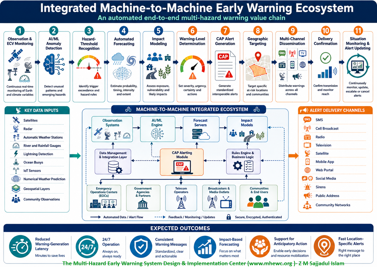
The system is therefore envisioned as an integrated machine-to-machine early warning ecosystem, synchronizing and integrating a step forward process from 1) Observation and ECV monitoring, 2) AI/ML anomaly detection ; 3) hazard threshold recognition; 4) automated forecasting;5) impact modeling; 6) warning-level determination; 7) CAP alert generation; 8) geographic targeting; 9) multichannel dissemination; 10) delivery confirmation;11) situation monitoring and alert updating.
An integrated machine-to-machine early warning ecosystem should function as a synchronized, interoperable, and continuously operating digital architecture that connects the entire warning value chain from environmental observation and hazard detection to automated alert generation, dissemination, delivery verification, and continuous situation updating. Rather than operating as separate institutional or technological components, the system would enable sensors, forecasting platforms, analytical engines, decision support systems, CAP servers, telecommunications networks, broadcasters, emergency platforms, and community-level dissemination channels to exchange data and automatically trigger predefined actions in near real time.
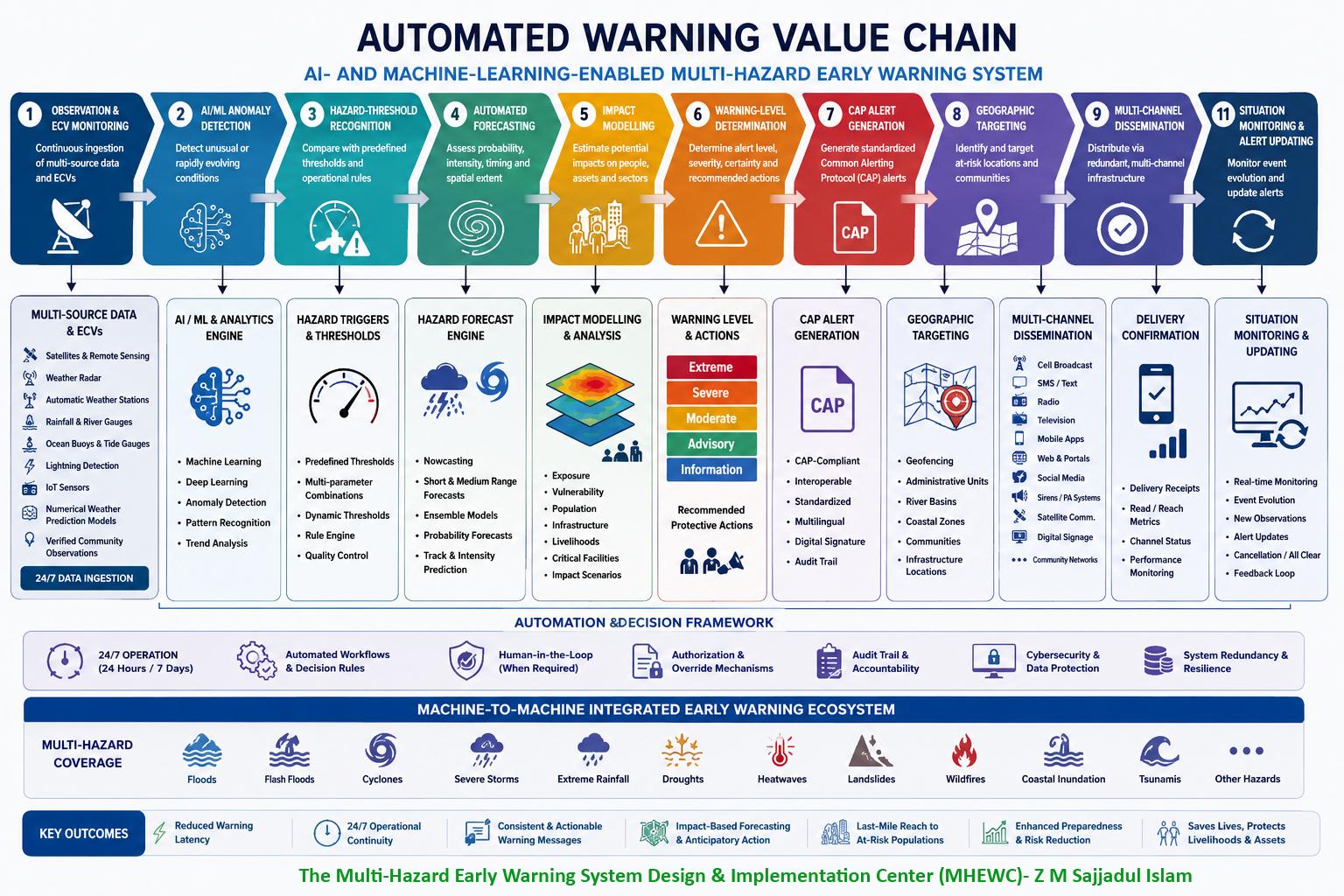
The architecture would operate through an interconnected step-forward process:
1) Observation and Essential Climate Variable (ECV) Monitoring
The system continuously acquires and integrates real-time and near-real-time data from multiple sources, including satellites, weather radar, automatic weather stations, rainfall and river gauges, ocean buoys, lightning detection networks, IoT sensors, hydrological monitoring stations, remote-sensing platforms, numerical weather prediction models, geospatial databases, and verified community observations. Essential Climate Variables and other environmental indicators are continuously monitored to establish the baseline conditions from which emerging hazards can be detected.
2) AI/ML for Detection of Anomalies
Artificial intelligence and machine learning algorithms automatically analyze incoming data streams to identify unusual patterns, rapid changes, abnormal trends, spatial clusters, or combinations of environmental variables that may indicate the emergence or intensification of a hazard. The analytical engine can compare current conditions with historical records, seasonal climatology, model outputs, and previously observed hazard signatures.
3) Hazard threshold recognition
Detected anomalies are evaluated against predefined and dynamically adjustable hazard thresholds, trigger levels, operational rules, and multiparameter criteria. These thresholds may include rainfall intensity and duration, river levels, wind speed, temperature, soil moisture, storm surge, drought indices, lightning density, wave height, landslide susceptibility, or combinations of indicators. When a threshold or combination of thresholds is reached, the system automatically initiates the next stage of the warning workflow.
4) Automated forecasting
Once a potential hazard is detected and validated through anomaly recognition and predefined trigger criteria, the system activates an automated forecasting engine designed to calculate, verify, and continuously update the critical parameters that determine the likely development and severity of the event. This forecasting engine would combine deterministic, probabilistic, statistical, physical, and AI/ML-based models to estimate the likelihood, magnitude, intensity, timing, duration, trajectory, rate of development, spatial extent, confidence level, and probable future evolution of the hazard.
The automated forecasting process would first calculate and verify the relevant hazard parameters and trigger thresholds associated with each hazard type. Depending on the event, these parameters may include rainfall intensity and accumulation, river discharge and water level, storm surge height, wind speed and direction, atmospheric pressure, temperature, soil moisture, drought indices, wave height, lightning density, soil saturation, slope instability, fire-weather indices, or other hazard-specific indicators. The system would continuously compare observed and forecast values against predefined operational thresholds, historical extremes, return periods, impact thresholds, and locally calibrated trigger levels.
A key function of the forecasting engine would be the automatic verification of hazard triggers. Instead of relying on a single threshold, the system could assess combinations of variables and multi-parameter conditions to reduce false alarms and improve forecast confidence. For example, a flash-flood trigger could combine short-duration rainfall intensity, antecedent soil moisture, catchment saturation, river response, terrain characteristics, and forecast precipitation. Similarly, a cyclone warning trigger could integrate wind speed, central pressure, storm trajectory, sea-surface temperature, expected rainfall, wave conditions, and projected storm surge.
The forecasting platform may integrate multiple complementary modeling approaches, including nowcasting, numerical weather prediction, ensemble forecasting, hydrological and hydraulic modeling, ocean and storm-surge modeling, statistical forecasting, remote-sensing-derived prediction, and AI/ML-based forecasting. These different model outputs can be blended using automated model weighting or consensus techniques to generate a more robust forecast and reduce dependence on any single model.
For rapidly developing hazards, nowcasting systems can provide very short-range forecasts by analysing high-frequency radar, satellite, lightning, rainfall, wind, and surface-observation data. These systems can be particularly important for severe thunderstorms, flash floods, extreme rainfall, lightning, localized windstorms, and rapidly intensifying convective systems where warning lead times may be measured in minutes rather than hours.
For longer lead times, numerical weather prediction and ensemble forecasting systems can provide probabilistic information on possible future scenarios. The automated engine can compare multiple model runs and ensemble members to determine the probability of threshold exceedance, quantify forecast uncertainty, identify the most likely event trajectory, and estimate the range of plausible outcomes. This allows the warning system to distinguish between low-confidence emerging risks and high-confidence severe events.
Hydrometeorological forecasting can also be dynamically linked so that atmospheric forecasts automatically drive hydrological, hydraulic, coastal, landslide, drought, or other hazard-specific models. Forecast rainfall, for example, may automatically feed river-basin models to estimate discharge and flood levels, while cyclone forecasts may feed storm-surge and coastal-inundation models. In this way, the forecasting architecture progresses from predicting meteorological conditions to forecasting actual hazard behavior.
The system should also support continuous forecast updating and data assimilation. As new satellite observations, radar scans, station measurements, river-gauge readings, ocean observations, IoT sensor data, community reports, or updated model outputs become available, the forecasting engine recalculates the event characteristics and modifies the forecast accordingly. This creates a dynamic forecasting process in which predictions become progressively more accurate as the event approaches and more observational evidence becomes available.
Artificial intelligence and machine learning can further enhance this process by identifying relationships between observed conditions, historical events, model biases, trigger exceedances, and actual hazard outcomes. Over time, the system can use verified event data to recalibrate forecasting models, refine thresholds, improve parameter weighting, detect recurring biases, and strengthen predictive performance. Such capabilities can support a self-improving forecasting environment, while still maintaining expert-defined operational rules and institutional oversight.
The automated forecasting engine should also quantify forecast confidence and uncertainty. Rather than producing only a single deterministic prediction, the system can calculate probability ranges, confidence intervals, scenario likelihoods, and threshold-exceedance probabilities. These uncertainty indicators can then be passed directly to the next stages of the warning value chain, including impact modeling and warning-level determination.
A mature automated forecasting architecture would therefore generate a continuously updated set of outputs such as: Hazard probability; expected magnitude and intensity; threshold exceedance; onset time; duration; trajectory; spatial extent ; rate of intensification; uncertainty and confidence; expected evolution; scenario updates. The objective is to transform forecasting from a predominantly manual, sequential process into a real-time, machine-to-machine predictive capability in which incoming observations automatically trigger model execution, parameter calculation, threshold verification, forecast updating, uncertainty analysis, and onward transmission of forecast outputs to impact-modeling and warning-decision systems.
In an integrated early warning architecture, the automated forecasting component therefore serves as the critical bridge between hazard detection and impact prediction, ensuring that the system not only recognizes that an abnormal condition is occurring, but also determines what is likely to happen next, when it will happen, where it will occur, how severe it may become, and with what level of confidence.
Considering all of these factors, dedicated AI- and machine-learning-based algorithms should be developed, calibrated, validated, and operationalized to automatically generate hazard forecasts, determine appropriate warning levels, and produce standardized Common Alerting Protocol (CAP) alerts based on real-time observations, forecast parameters, trigger thresholds, expected impacts, geographic targeting, and predefined operational rules.
5) Impact modeling for weather forecasting
Once a weather or climate-related hazard has been detected and forecast, the system should automatically translate the physical forecast into an assessment of its potential consequences for people, infrastructure, livelihoods, services, economic activities, ecosystems, and critical facilities. This represents the transition from conventional hazard forecasting describing what the weather will be to impact-based forecasting, which explains what the weather is likely to do, where the impacts may occur, who or what may be affected, and what actions may be required.
The impact-modeling engine would automatically combine real-time and forecast hazard information with geospatial datasets describing exposure, vulnerability, population distribution, buildings, infrastructure, land use, livelihoods, agriculture, critical facilities, mobility patterns, socioeconomic conditions, environmental characteristics, and historical impact information. Through this integration, the system can estimate the likely consequences of an approaching or evolving weather event at national, sub-national, local, and community levels.
For each forecast event, the impact-modeling process should first characterize the expected hazard intensity, probability, timing, duration, spatial footprint, trajectory, rate of development, and forecast confidence. These hazard parameters are then overlaid with exposure and vulnerability information to identify which populations, assets, sectors, and locations fall within the anticipated impact area.
For example, an extreme-rainfall forecast should not simply state that 150 mm of rainfall may occur within 24 hours. The automated impact model should assess where that rainfall may cause flash flooding, river flooding, urban drainage congestion, landslides, road disruption, crop damage, water contamination, displacement, or interruption of essential services. Similarly, a cyclone forecast should move beyond expected wind speed and storm track to estimate potential impacts from destructive winds, extreme rainfall, storm surge, coastal inundation, infrastructure damage, power disruption, transportation interruption, agricultural losses, and population displacement.
The system may therefore apply the basic analytical relationship: Forecast Hazard × Exposure × Vulnerability × Susceptibility/Fragility = Expected Impact
However, operational impact modeling should go beyond a simple static overlay. AI, machine learning, GIS, remote sensing, statistical analysis, historical loss databases, vulnerability functions, fragility curves, digital elevation models, hydrological models, population datasets, and sector-specific impact thresholds can be integrated to estimate the probable consequences of different hazard intensities.
The impact-modeling engine could analyze several interconnected components:
5.1)Hazard characteristics:
Forecast rainfall, wind speed, temperature, river discharge, storm surge, wave height, lightning activity, soil moisture, drought conditions, fire-weather indices, or other weather-related parameters are translated into spatial hazard-intensity layers.
5.2)Exposure analysis:
The system identifies the people and assets located within the forecast hazard footprint. This may include population settlements, households, schools, hospitals, roads, bridges, airports, ports, telecommunications infrastructure, power facilities, water systems, agricultural areas, livestock, industries, markets, evacuation centres, and other critical assets.
5.3)Vulnerability and fragility Analysis:
The system assesses how susceptible exposed populations and assets are to the expected hazard intensity. Vulnerability indicators may include housing quality, poverty, age, disability-related accessibility needs, settlement type, access to services, infrastructure condition, livelihood dependence, building materials, drainage capacity, agricultural sensitivity, and historical disaster impacts.
5.4)Dynamic mobility analysis:
Where data are available, the system may incorporate mobility and time-dependent exposure information. Population exposure can vary considerably between daytime and night-time, weekdays and holidays, seasonal migration periods, market days, tourism seasons, school hours, or evacuation periods. Dynamic exposure modeling can therefore improve the accuracy of location-specific impact forecasts.
5.5)Critical infrastructure and service disruption:
Impact models should evaluate the probability that weather hazards will disrupt essential infrastructure and services. This may include electricity networks, telecommunications, hospitals, water-supply systems, transportation corridors, bridges, ports, airports, schools, emergency facilities, and supply chains. Understanding potential service disruption is particularly important for emergency planning and anticipatory action.
5.6)Livelihood and economic impacts:
Forecast hazards can be linked with agricultural calendars, crop types, livestock concentrations, fisheries, markets, industrial areas, tourism facilities, and other livelihood datasets to estimate possible economic disruption and livelihood losses. For example, the same rainfall intensity may have very different consequences depending on whether it occurs during planting, flowering, harvesting, or post-harvest periods.
5.7) Environmental and ecosystem impacts:
Impact modeling may also include forests, wetlands, coastal ecosystems, river basins, soil conditions, erosion-prone areas, wildfire-sensitive landscapes, and other environmental assets. This can support forecasting of secondary impacts such as erosion, sedimentation, water-quality deterioration, ecosystem degradation, or post-event landslide risk. The modelling platform should also assess compound and cascading impacts. Weather hazards frequently do not occur in isolation. Extreme rainfall may produce flash flooding, river flooding, landslides, infrastructure failure, power disruption, transport interruption, and disease risks in sequence. Cyclones may simultaneously generate destructive winds, storm surge, coastal inundation, extreme rainfall, flooding, saline-water intrusion, and telecommunications failure. Automated modelling should therefore evaluate interconnected hazard and impact pathways rather than treating each consequence independently.
AI and machine-learning algorithms can strengthen impact modelling by analysing relationships between historical weather conditions, hazard intensity, exposure patterns, vulnerability indicators, recorded damage, disruption, casualties, displacement, agricultural losses, and service interruptions. These relationships can help predict the expected severity of future impacts when similar combinations of conditions arise.
The system should also use impact thresholds in addition to physical hazard thresholds. For example, a particular rainfall amount may produce little disruption in one location but severe flooding in another because of differences in topography, drainage, urbanization, soil saturation, river conditions, or settlement vulnerability. Therefore, warning decisions should increasingly be based on location-specific impact thresholds rather than uniform meteorological thresholds alone.
Automated impact modeling should generate several possible scenarios where forecast uncertainty remains significant. These could include: Most likely scenario ; reasonable worst-case scenario ; lower-impact scenario. Each scenario can identify the probable geographic footprint, exposed population, affected assets, anticipated service disruptions, and required preparedness or early-action measures. Probabilistic modelling can also estimate the likelihood of exceeding specific impact thresholds. For example: 30% probability: localized flooding and minor road disruption, 60% probability: widespread urban flooding and transport interruption, 80% probability: severe flooding affecting settlements, critical infrastructure, and essential services. This approach allows decision-makers to act before certainty becomes absolute.
The impact-modeling engine should continuously update its analysis as new weather observations and forecasts become available. Updated radar information, satellite products, automatic weather station data, river levels, soil-moisture observations, community reports, emergency-service information, and model outputs can automatically modify the predicted impact footprint. The system can therefore increase or decrease the expected severity, extend or reduce affected areas, and revise population and infrastructure exposure estimates as the event evolves.
Impact forecasts should ultimately generate operational outputs such as: Forecast Hazard, Hazard Intensity Map, Exposure Analysis, Vulnerability Analysis, Impact Probability, Expected Severity, Affected Population, Critical Infrastructure at Risk, Sectoral Impacts, Priority Geographic Areas, Recommended Early Actions.
The resulting information should automatically feed into the next stage of the warning value chain warning-level determination. If the model predicts severe impacts on densely populated communities, hospitals, transport networks, coastal settlements, agricultural areas, or other critical assets, the system may automatically recommend escalation to a higher warning category even when the underlying meteorological parameter alone would not normally justify such escalation.
Impact modeling should also be linked to anticipatory action and emergency preparedness protocols. Once predefined impact thresholds are reached, the system could trigger recommendations or pre-authorized actions such as evacuation readiness, pre-positioning of emergency supplies, activation of emergency operation centres, protection of critical infrastructure, temporary school closure, livestock relocation, reservoir management, deployment of rescue resources, or activation of forecast-based financing mechanisms.
The objective is therefore to establish an automated weather-to-impact intelligence chain: a) Weather Observation b) Weather Forecast c) Hazard Forecast d) Exposure Analysis e) Vulnerability Analysis f) Impact Modelling g) Impact Probability h) Impact Severity i) Geographic Prioritization j) Warning Decision and finally h) Protective and Anticipatory Action. Through this architecture, the early warning system would no longer simply forecast rainfall, wind, temperature, river levels, or storm tracks. It is an impact forecast that predicts the likely human, infrastructural, economic, livelihood, and environmental consequences of the predicted weather. The forecast validation authorities and communities to understand not only what weather is coming, but more importantly what that weather is likely to do and what actions should be taken before the impacts occur in advance.
6) Warning level determination
Based on forecast confidence, hazard severity, expected impacts, geographic coverage, lead time, and predefined operational criteria, the system automatically determines the appropriate warning level. This may include advisory, watch, warning, severe, or extreme categories, together with urgency, severity, certainty, recommended protective actions, escalation procedures, and sector-specific response measures.
Forecast confidence means the degree of trust or reliability assigned to a forecast, based on the strength, consistency, quality, and uncertainty of the evidence supporting it. It answers the operational question: “How confident are we that the forecast scenario and its predicted magnitude, timing, location, and impacts are reasonably correct?”
In an automated Multi-Hazard Early Warning System, forecast confidence should not be based on one model alone. It can be calculated from several factors, including:
- Agreement among ensemble members: whether multiple model simulations indicate similar outcomes.
- Agreement among different forecasting models: whether NWP, AI/ML, hydrological, ocean, or other models produce consistent results.
- Observational confirmation: whether radar, satellites, AWS, river gauges, lightning sensors, buoys, or ground observations support the forecast.
- Model skill and historical performance: how accurately the model has previously predicted similar events in the same location and season.
- Data quality and availability: completeness, timeliness, accuracy, and spatial density of observational data.
- Forecast lead time: confidence generally changes as the event approaches and additional observations become available.
- Track and spatial uncertainty: uncertainty about exactly where the event or highest impacts will occur.
- Intensity uncertainty: confidence in predicted rainfall, wind speed, river level, surge height, temperature, or other hazard parameters.
- Timing uncertainty: confidence regarding onset, peak, duration, and ending time.
- Threshold-exceedance probability: likelihood that predefined warning or impact thresholds will actually be exceeded.
- Consistency between successive forecasts: whether consecutive model runs maintain, strengthen, weaken, or substantially shift the forecast scenario.
- AI/ML confidence scores: probabilistic confidence generated from historical training, pattern recognition, model verification, and real-time observations.
Forecast Confidence = Model Agreement + Ensemble Consistency + Observational Verification + Historical Model Skill + Data Quality + Temporal/Spatial Certainty. It could then be operationally classified, for example, as Very Low , Low , Moderate , High ,Very High, with nationally calibrated quantitative criteria behind each category.
For example, suppose ensemble forecasts indicate a 75% probability of rainfall exceeding 150 mm/24 hours, several NWP models show the same affected area, radar and satellite observations confirm rapidly developing convection, and successive forecast runs remain consistent. The system may assign High Forecast Confidence. If models disagree substantially on rainfall amounts and location and observations provide weak confirmation, confidence might remain Low or Moderate, even though one model predicts an extreme event.
Importantly, forecast confidence is not the same as hazard severity. A forecast can indicate a very severe event with low confidence, or a moderate event with very high confidence. Warning-level determination should therefore consider both independently: Hazard Severity + Probability + Forecast Confidence + Expected Impact + Exposure/Vulnerability + Lead Time = Warning Decision
6.1) Hazard severity assessment
The warning engine should first assess the forecast physical intensity of the hazard against predefined hazard-specific thresholds. Depending on the hazard, relevant parameters may include: rainfall intensity and accumulated precipitation, river level and discharge; flood depth and flow velocity; wind speed and gust intensity, cyclone category and central pressure; storm-surge height; wave height; extreme temperature; heat index; drought severity; lightning density; soil saturation; landslide probability; fire-weather index; snowfall or snow accumulation; visibility; coastal inundation depth; and other nationally defined hazard indicators.
Observed and forecast parameters would automatically be compared against historical records, return periods, operational thresholds, climatological extremes, and locally calibrated hazard-trigger values. The system can therefore determine whether the event represents a minor, moderate, significant, severe, or extreme physical hazard.
6.2) Probability and forecast confidence
Warning decisions should not depend only on forecast intensity. The system should determine the probability that the event will occur and quantify the confidence associated with the forecast. This may include: Probability of occurrence, probability of threshold exceedance , ensemble agreement , model consistency , observational confirmation , forecast confidence.
For example, an extremely severe scenario with only a very low probability may require a different warning response from a moderately severe event with very high certainty. The warning engine could therefore classify forecast confidence as: Very Low , Low , Moderate , High , Very High or according to nationally approved categories.
AI/ML algorithms can continuously compare forecasts from different models, observations, ensemble members, radar, satellite products, and historical forecast performance to estimate the reliability of the warning decision.
6.3) Expected impact severity
The warning level should be strongly influenced by what the forecast hazard is expected to do, rather than only by the magnitude of the physical hazard.
The system should therefore analyze projected: fatalities and injuries; population exposure; displacement potential; housing damage; agricultural losses; livestock impacts; road and bridge disruption; power outages; telecommunications disruption; interruption of water supply; health-service disruption; impacts on schools; damage to critical infrastructure; transportation interruption; livelihood losses; coastal inundation; environmental impacts; and cascading or secondary hazards.
An event that is meteorologically moderate but affects a highly vulnerable, densely populated location may consequently justify a higher warning level than a stronger event occurring over an unpopulated area.
The operational logic should therefore recognize: Hazard intensity does not automatically equal impact severity.
6.4) Exposure and vulnerability consideration
Warning-level determination should incorporate the characteristics of the population and assets within the forecast impact area. The decision engine may analyse: Population density → settlement type → poverty → housing condition → age distribution → accessibility requirements → livelihood sensitivity → infrastructure fragility → evacuation capacity → historical disaster impacts. For example, identical rainfall forecasts may generate different warning levels for two locations if one is a well-drained urban area while the other contains highly flood-prone informal settlements. This allows warnings to become location-specific, vulnerability-sensitive, and impact-oriented.
6.5) Geographic coverage
The system should determine the precise spatial extent for which the warning applies. Using GIS and geospatial forecasting, warning levels may be assigned at multiple scales, including: national; province or state; district; Union/Commune/Traditional Authority; Village; municipality; river basin; coastal zone; watershed; urban neighborhood; community; transportation corridor; geofenced polygon; or other hazard-specific areas. Different locations within the same weather system may therefore receive different warning levels. For example: Area A – Advisory, Area B – Watch, Area C – Warning, Area D – Extreme Warning. This prevents unnecessary nationwide alerts and enables more precise geographic targeting of at-risk populations.
6.6) Lead-Time assessment
Available lead time is another critical variable. The system should automatically calculate: Forecast generation time , expected hazard onset , available warning lead time , minimum action time required. A slowly evolving river flood may provide several days of lead time, whereas a flash flood, tornado, severe thunderstorm, landslide, or tsunami may provide only minutes. Warning logic should therefore account for how quickly people and institutions must act. Where lead time is extremely short, the system can prioritize immediate dissemination and predefined protective instructions instead of waiting for extended sequential approval procedures.
6.7) Rate of hazard intensification
The warning engine should also detect whether conditions are stable, gradually worsening, or rapidly intensifying.
AI/ML systems can continuously analyze: Rate of change , acceleration, threshold proximity, threshold exceedance, probability of further intensification. Rapid intensification should be able to trigger an automatic escalation from one warning category to another. For example: Advisory, Watch , Warning, Severe/Extreme Warning if observed and forecast conditions deteriorate rapidly.
6.8) Warning-level classification
Based on the combined assessment, the system would determine the appropriate nationally approved warning category. A configurable framework might include:
Advisory : Potentially hazardous conditions are developing; increased awareness is recommended.
Watch : Conditions are favourable for a hazardous event or there is an increasing probability that significant impacts may occur; preparedness measures should begin.
Warning : A hazardous event is occurring, imminent, or highly likely and protective action is required.
Severe Warning : Major or potentially life-threatening impacts are expected, requiring immediate preparedness, evacuation, emergency-response, or other protective actions.
Extreme/Emergency warning: Catastrophic or exceptionally dangerous conditions are imminent or occurring, requiring urgent life-saving action.
These categories should remain nationally configurable, since terminology, colour coding, thresholds, mandates, and authorization requirements vary among countries and hazards.
6.9) Multi-Parameter decision matrix
The system should apply a predefined Warning Decision Matrix rather than relying on one trigger alone.
For example:
- Hazard Intensity + Impact Severity + Probability + Confidence + Exposure + Lead Time = Recommended Warning Level.
- A simplified conceptual matrix could operate as follows: Low hazard + low impact + low probability = Monitoring/No Warning
- Moderate hazard + limited impact + moderate probability = Advisory
- Significant hazard + increasing impact probability = Watch
- High hazard + significant expected impacts + high confidence = Warning
- Very high hazard + severe impacts + high probability = Severe Warning
- Extreme hazard + catastrophic consequences + imminent occurrence > Extreme/Emergency Warning
The exact thresholds should be scientifically calibrated, hazard-specific, location-specific, periodically reviewed, and approved by the responsible national authority.
6.10) AI/ML-Supported warning decision
AI and machine-learning algorithms can support warning-level determination by analyzing historical relationships between: Forecast conditions > hazard occurrence > observed impacts > warning levels previously issued > actions taken > actual outcomes.
Over time, the system can identify patterns associated with under-warning, over-warning, missed events, false alarms, and successful warning decisions. Machine learning could therefore support: probability estimation; threshold optimization; pattern recognition; impact classification; warning-level recommendations; forecast confidence scoring; geographic prioritization; anomaly detection; escalation prediction; and false-alarm reduction.
However, operational warning rules should remain transparent, auditable, institutionally approved, and capable of being overridden by authorized personnel.
6.11) Urgency determination
Once the warning level is determined, the platform should calculate the urgency of the event. Depending on the applicable CAP or national warning framework, urgency may indicate whether protective action is required: Immediately > within a short period > within several hours > within several days > preparation only. Urgency should be determined from the expected onset time, rate of intensification, required evacuation time, population vulnerability, and expected consequences.
6.12) Severity determination
The system should classify the expected severity of consequences. The classification may distinguish among: Minor > Moderate > Severe > Extreme based on anticipated impacts on: life and safety + livelihoods + infrastructure + services + economy + environment. This severity classification can subsequently populate the corresponding fields within the CAP alert.
6.13) Certainty determination
The platform should separately determine the level of certainty associated with the event. Certainty may be derived from: observational confirmation; model agreement; ensemble probabilities; forecast consistency; historical model skill; forecast verification/fitness checking from radar and satellite confirmation; sensor verification; and AI/ML confidence scores. An alert may therefore distinguish between an event that is possible, likely, observed, or highly certain, according to the terminology used by the applicable warning framework.
6.14) Automatic protective-action selection
Warning determination should not end with assigning a colour or warning category. The system should automatically associate each warning level and expected impact with appropriate protective and anticipatory actions. Depending on the hazard, recommended actions might include: monitor official information; avoid low-lying areas; move livestock and equipment; suspend fishing activities; secure boats and coastal assets; avoid unnecessary travel; close schools; protect critical infrastructure; activate emergency operation centres; pre-position emergency supplies; deploy search-and-rescue resources; evacuate designated areas; move to higher ground; activate shelters; or initiate forecast-based financing and anticipatory action. Protective recommendations should be hazard-specific, geographically relevant, actionable, and understandable by the intended population.
6.15) Sector-specific warning measures
The same hazard may have different implications for different sectors. The automated warning engine should therefore generate differentiated guidance for: General population; Disaster management; Health; Agriculture; Fisheries; Water resources; Transport; Aviation; Maritime operations; Energy; Telecommunications; Education; Local government; Humanitarian agencies.
For example, a cyclone warning might simultaneously trigger: Public: prepare for evacuation. Ports: suspend vessel movement. Fisheries: return vessels to safe harbour. Hospitals: activate emergency staffing. Power utilities: prepare repair teams. Local governments: open shelters. Humanitarian agencies: pre-position emergency supplies. This transforms the warning into an operational decision-support product.
6.16) Automatic escalation and de-escalation
Warning levels should remain dynamic throughout the hazard’s life cycle. As new observations and forecasts become available, the system continuously recalculates: Hazard severity > probability > confidence > impact > exposure > warning level. If conditions deteriorate, the system can automatically recommend or trigger escalation: Watch > Warning > Severe Warning > Extreme Warning. Similarly, when conditions improve: Extreme Warning > Warning > Advisory > All Clear/Termination. This creates a continuously updated warning process rather than a one-time decision.
6.17) Human-in-the-loop and automated authorization
Different warning levels may require different authorization arrangements. For predictable, high-confidence, rapidly evolving hazards, governments may establish pre-authorized machine-to-machine warning procedures where scientifically validated thresholds automatically trigger dissemination. For example: Threshold reached > verified automatically > warning level calculated > CAP generated > dissemination initiated. For high-impact, uncertain, unprecedented, or politically sensitive events, the system may instead require: AI recommendation > forecaster validation > authorized approval > CAP issuance. A hybrid system can therefore balance speed, scientific reliability, institutional accountability, and public safety.
6.18) Auditability and decision transparency
Every warning-level decision should generate a complete digital audit trail documenting: observations used; forecast models used; thresholds reached; probabilities calculated; confidence levels; impact estimates; warning-level recommendation; algorithm version; authorization status; time of decision; alert issuance; subsequent updates; and any human override. Such traceability is essential for accountability, post-event analysis, system improvement, and public trust.
6.19 ) Automated CAP alert generation.
The CAP engine can automatically translate the warning decision into interoperable alert fields, geographic polygons, timestamps, instructions, severity, urgency, certainty, and dissemination parameters.
Integrated warning decision chain
The complete automated decision process can therefore operate as:
Hazard Forecast > Threshold Verification > Probability Assessment > Forecast Confidence > Exposure & Vulnerability Analysis > Impact Severity > Geographic Prioritization > Lead-Time Assessment > Warning-Level Determination > Urgency, Severity & Certainty Classification > Protective-Action Selection > Authorization > CAP Alert Generation > Multi-Channel Dissemination.
The objective is to transform warning-level determination from a largely subjective or manually sequential process into a scientifically calibrated, impact-based, transparent, auditable, and machine-readable decision system capable of converting complex forecast information into a clear operational warning within seconds or minutes.
In this architecture, the essential question changes from simply:
“How severe will the weather or hazard be?”
to:
“How likely is the event, how severe will its consequences be, who and what will be affected, how much time remains to act, and what warning level and protective action are required now?”
This approach would enable an automated Multi-Hazard Early Warning System to issue faster, more geographically precise, impact-oriented, and actionable warnings, while maintaining human oversight, institutional accountability, and configurable national warning protocols where required.
7) CAP Alert generation
The warning decision is automatically converted into a standardized Common Alerting Protocol (CAP) message. The CAP alert can include the hazard type, affected area, urgency, severity, certainty, effective time, expiry time, recommended actions, instructions, source authority, language, geospatial polygons, and other standardized metadata. CAP enables a single authoritative alert to be understood and redistributed by multiple systems and communication platforms without having to manually recreate the warning for each channel.
8) Geographic targeting
The system identifies the precise locations, administrative units, communities, infrastructure corridors, river basins, coastal zones, urban areas, or other geographic areas expected to be affected. Geofencing, GIS layers, exposure databases, mobile network location systems, and location-based alerting technologies can then be used to ensure that warnings are directed primarily to populations and institutions within the threatened area.
9) Multi-channel dissemination
Once authorized or automatically triggered under predefined rules, the warning is simultaneously distributed through a redundant dissemination infrastructure. Channels may include cell broadcast, SMS, radio, television, satellite communication, mobile applications, websites, social media platforms, sirens, public address systems, digital signage, emergency telecommunications systems, local government networks, community organizations, and other last-mile communication mechanisms. A multichannel approach increases the probability that warnings will reach people even when individual communication systems are disrupted.
9) Delivery confirmation
The system does not end with transmission. It continuously verifies whether alerts have actually reached intended communication gateways, broadcasters, telecom networks, local authorities, devices, and target populations. Delivery receipts, transmission logs, network acknowledgments, platform analytics, geographic reach indicators, and other feedback mechanisms can be used to identify gaps, delays, failed channels, or underserved areas. Where necessary, the system can automatically activate alternative dissemination routes.
11) Situation Monitoring and Alert updating
Following dissemination, the automated ecosystem continues monitoring the evolving hazard and its impacts. New observations, updated forecasts, field reports, sensor readings, community feedback, and emergency operation information are continuously incorporated into the system. Alerts can therefore be updated, escalated, downgraded, extended, geographically modified, or canceled as conditions change. This creates a continuous feedback loop rather than a one-time warning process.
Together, these eleven functions establish a closed-loop, machine-to-machine early warning architecture in which information flows continuously from observation to analysis, decision, communication, verification, and reassessment. The system can operate 24 hours a day, seven days a week, enabling rapidly evolving hazards to be detected and communicated without waiting for conventional office-hour procedures.
For highly time-critical and well-understood hazards, predefined thresholds and authorization rules could enable preauthorized automated warning workflows with minimal or no real-time human intervention. For high-impact, uncertain, or complex events, the same architecture can retain human-in-the-loop validation, institutional authorization, escalation protocols, audit trails, cybersecurity controls, override mechanisms, and accountability safeguards.
The ultimate objective is to transform the early warning value chain from a sequence of manually disconnected processes into an integrated, intelligent, interoperable and continuously learning warning ecosystem capable of detecting hazards, forecasting their consequences, determining appropriate warning levels, generating standardized alerts, reaching the right population through multiple channels, verifying delivery, and continuously updating warnings as the situation evolves.
Integrated Machine-to-Machine Warning Value Chain: Observation & ECV Monitoring > AI/ML Anomaly Detection > Hazard Threshold Recognition > Automated Forecasting > Impact Modeling > Warning Level Determination > CAP Alert Generation > Geographic Targeting > Multi-Channel Dissemination > Delivery Confirmation > Situation Monitoring & Alert Updating > Continuous Feedback to Observation and Forecasting.
A county-level national hazard and disaster declaration framework needs to be instrumented with an AI-automated system so that highly time-critical alerts can be disseminated through pre-authorized workflows with minimal or no real-time human intervention, particularly for hazards where minutes can determine whether exposed populations receive sufficient lead time to act. For higher-impact or lower-confidence events, human-in-the-loop validation which is an automated AI/ML early warning system can detect hazards, assess impacts, and prepare alerts automatically, but a designated human expert or authorized duty officer (remaining on shift duty ) reviews and approves certain outputs before public dissemination (for time-critical hazard alerts, landslides, flash flooding, mudslides, infrastructure collapse, etc.). Escalation rules, audit trails, authorization protocols, and override mechanisms can remain embedded within the system to maintain institutional accountability and prevent erroneous alerts.
Way Forward: What we can do, what we are currently doing, and what we plan to do. Please share progress, ongoing initiatives, and future plans:
The objective of MHEWC’s automation initiative extends far beyond automating forecasting alone. It is intended to stimulate intensive international research, innovation, and technology development among universities, research institutions, technical agencies, private-sector technology providers, and early warning practitioners, while advancing the establishment of a fully integrated, intelligent, interoperable, and end-to-end Multi-Hazard Early Warning System (MHEWS).
The envisioned architecture would be capable of continuously detecting emerging hazards, identifying abnormal environmental and climatic conditions, interpreting their potential impacts, determining warning thresholds and levels, generating actionable, location-specific alerts, and rapidly and reliably disseminating those warnings to populations at risk through a highly automated, machine-to-machine operational process.
Ultimately, such an architecture could significantly reduce warning-generation and dissemination latency, strengthen uninterrupted 24/7 operational continuity, improve the consistency, accuracy, and timeliness of warning messages, and enhance impact-based forecasting, forecast-based financing, anticipatory action, and emergency preparedness. It would also help ensure that a rapidly developing extreme event, even one emerging at midnight or during periods of limited staffing, can trigger an immediate, authoritative, geographically targeted, and actionable warning without being delayed by conventional office-hour decision-making procedures.
MHEWC therefore envisages this initiative not merely as a technological automation programme, but as a platform for international research and development, scientific collaboration, AI and machine-learning innovation, interoperability, and operational transformation across the entire early warning value chain. Let’s schedule a technical call to discuss developing a partnership for innovation and system deployment.