Climate risk and vulnerabilities of Tajikistan
Tajikistan is highly vulnerable to climate change and multi-hazard risks because of its steep mountainous terrain, active seismic setting, glacier-fed river systems, fragile slopes, high dependence on water resources, climate-sensitive agriculture, hydropower dependence, limited transport connectivity, and exposure of rural and mountain communities to recurrent disasters. Tajikistan is a landlocked lower-middle-income country in Central Asia, and its mountainous geography strongly shapes its disaster and climate-risk profile. (World Bank)
Tajikistan is highly exposed and vulnerable to climate change and multi-hazard risks due to its steep mountainous terrain, active seismic setting, glacier-fed river systems, fragile slopes, dependence on water resources, hydropower and irrigated agriculture, and exposure of rural and mountain communities to recurrent disasters. The country faces major risks from earthquakes, floods, flash floods, mudflows, landslides, avalanches, droughts, heat stress, glacier retreat, glacial lake outburst floods, water scarcity, soil erosion, agricultural losses, hydropower disruption, and climate-sensitive health impacts. Climate change is expected to intensify these vulnerabilities through rising temperatures, accelerated glacier melt, more variable river flows, more intense rainfall extremes, increased flood and landslide risk, drought stress, reduced long-term water reliability, and growing pressure on food security, water security, energy, transport, public health, ecosystems, and vulnerable highland and rural communities. Strengthening multi-hazard early warning systems, impact-based forecasting, glacier and GLOF monitoring, flood and mudflow risk reduction, earthquake-safe infrastructure, drought and water-resource management, climate-resilient agriculture, hydropower resilience, resilient mountain transport, disaster risk financing, and locally led adaptation is essential to reduce losses and protect Tajikistan’s development gains.
1. Multi-hazard exposure
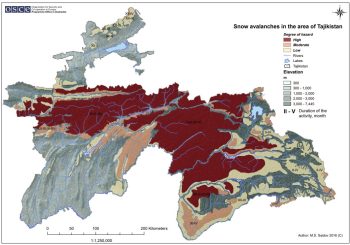
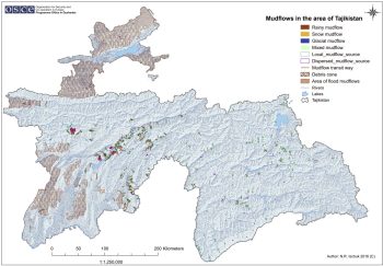
Tajikistan’s major hazards include earthquakes, floods, mudflows, landslides, flash floods, avalanches, rockfalls, droughts, extreme temperatures, and glacier-related hazards. UNDRR’s country disaster-risk profile identifies mudflows as the most commonly registered hazard, followed by floods, landslides, flash floods, and earthquakes. (PreventionWeb) GFDRR similarly emphasizes that Tajikistan’s steep mountainous terrain makes the country highly susceptible to earthquakes, floods, landslides, and avalanches. (GFDRR)
Risk is geographically differentiated. The Pamir and Gorno-Badakhshan mountain areas face glacier retreat, GLOFs, avalanches, earthquakes, landslides, mudflows, road isolation, and water-system disruption. The Rasht Valley, Khatlon, Sughd, Zeravshan Valley, Vakhsh basin, Pyanj basin, and mountain-to-lowland corridors face different combinations of flash floods, landslides, mudflows, drought, heat stress, irrigation stress, and agricultural losses. (Climate Change Knowledge Portal)
 2
2
2. Climate change as a risk multiplier
Climate change is making Tajikistan’s risk profile more complex because the country’s development depends heavily on the water-energy-agriculture nexus. The World Bank’s Tajikistan Country Climate and Development Report states that intense climate shocks threaten Tajikistan’s water, energy, agriculture, and connectivity systems. (World Bank) Climate-driven changes in temperature, precipitation, glacier melt, and runoff are increasing river-flow variability, threatening hydropower and water supply, reducing agricultural water availability, and complicating regional water-management arrangements. (World Bank)
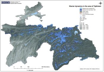
The World Bank/ADB climate-risk profile warns that glacier decline may reduce the regularity of water flows and could result in drying of some watersheds. (Climate Change Knowledge Portal) UNEP reported in 2025 that Tajikistan’s temperatures have risen at twice the global average, more than 1,000 glaciers have disappeared in recent decades, and 1,826 natural disasters were recorded between 2020 and 2023, underlining the country’s high exposure to climate-related shocks. (UNEP – UN Environment Programme)
3. Glacier retreat, GLOFs, water security, and hydropower vulnerability
Glacier retreat is one of Tajikistan’s most strategic long-term climate vulnerabilities. Glaciers and snowpack regulate river flows, irrigation water, hydropower generation, ecosystems, and downstream water availability. Tajikistan’s National Strategy for Adaptation to Climate Change notes that Fedchenko Glacier, the country’s largest glacier, has retreated by about 1 km and lost approximately 5 km³ of ice since the beginning of the 20th century. (Climate Policy Radar)
Glacier retreat can increase short- to medium-term risks through glacial lake growth, unstable slopes, floods, landslides, and mudflows, while also creating long-term risks to dry-season water availability. UNDP notes that glacier retreat is increasing climate-related risks across Central Asia, including floods, landslides, and water-management challenges. (UNDP) For Tajikistan, this is especially important because water is central to hydropower, irrigated agriculture, drinking water, and regional cooperation. (World Bank)
4. Flood, flash-flood, mudflow, and landslide vulnerability
Floods, flash floods, mudflows, and landslides are among Tajikistan’s most frequent and damaging hazards. Heavy rainfall, rapid snowmelt, glacier melt, unstable slopes, deforestation, road cutting, poor drainage, and settlement expansion in narrow valleys can quickly generate destructive flows that damage homes, roads, bridges, irrigation canals, schools, health facilities, electricity lines, water systems, and farmland. (PreventionWeb)
Climate change is expected to intensify simultaneous flooding and associated hazards such as landslides and mudslides, affecting lives, livelihoods, and infrastructure. (ReliefWeb) Mountain transport corridors are particularly vulnerable because a single landslide, mudflow, avalanche, or bridge failure can isolate communities, disrupt markets, delay emergency response, and increase recovery costs. (GFDRR)
5. Earthquake and cascading-risk vulnerability
Earthquake risk remains central to Tajikistan’s multi-hazard profile. Tajikistan lies in an active seismic region, and earthquakes can damage housing, schools, health facilities, dams, roads, bridges, hydropower assets, water systems, and public buildings. In mountainous areas, earthquakes can trigger cascading hazards such as landslides, rockfalls, avalanches, dam instability, road blockages, and secondary mudflows. (PreventionWeb)
Seismic risk is especially important where older buildings, remote settlements, narrow valleys, critical infrastructure corridors, and hydropower or reservoir assets overlap with landslide-prone terrain. Earthquake risk reduction therefore needs to be integrated with landslide mapping, resilient road design, school and hospital safety, dam safety, and community preparedness.
6. Drought, agriculture, and food-security vulnerability
Agriculture is highly climate-sensitive in Tajikistan because rural livelihoods depend on irrigated and rainfed farming, livestock, orchards, pastures, local water systems, and seasonal labour. Climate change threatens agricultural production and rural livelihoods through reduced rainfall, melting glaciers, floods, droughts, hailstorms, extreme temperatures, pests, soil erosion, and irrigation-water stress. (World Bank)
Drought and heat stress can reduce crop yields, pasture productivity, livestock health, and household income, while floods and mudflows can destroy fields, irrigation canals, rural roads, and market access. The World Bank’s climate and development work highlights that adapting water, hydropower, transport, agriculture, and land systems is central to Tajikistan’s climate resilience. (World Bank)
7. Water-energy-agriculture nexus vulnerability
Tajikistan’s climate risk is strongly concentrated in the water-energy-agriculture nexus. Water supports hydropower generation, irrigation, drinking water, ecosystems, and downstream transboundary flows. The World Bank notes that climate change in Tajikistan is largely about water, bringing more variability and instability to the country’s water resources, with growing risks for power production in winter, agriculture downstream in summer, and extremes such as glacial melt outbursts, floods, and droughts. (Open Knowledge Repository)
This nexus creates cascading risk. Reduced winter hydropower availability can affect energy security; reduced summer irrigation water can affect crops and food security; and floods or mudflows can damage hydropower, transport, and irrigation infrastructure. Record-low water levels at Nurek Hydropower Plant in 2024 were cited by the World Bank as an example of how runoff shifts are complicating water and energy management. (World Bank)
8. Health and social vulnerability
Climate change can worsen health risks through heat stress, unsafe water, diarrhoeal disease, malnutrition, disaster-related injuries, respiratory stress from dust and smoke, mental stress after displacement, and disruption of health services during floods, landslides, mudflows, avalanches, or earthquakes. Tajikistan’s climate-risk profile identifies health, water, agriculture, energy, and transport as key vulnerable systems. (Asian Development Bank)
The most vulnerable groups include smallholder farmers, rural households, women-headed households, children, older persons, people with disabilities, low-income households, mountain communities, households living along unstable slopes or flood-prone river channels, communities dependent on irrigation and livestock, and remote settlements with limited road access. Vulnerability is highest where climate exposure overlaps with poverty, weak housing, limited savings, poor road access, limited insurance, inadequate WASH systems, and weak last-mile early warning.
9. Sector-specific vulnerability summary
| Sector | Main climate and multi-hazard risks |
|---|---|
| Water resources | Glacier retreat, snowmelt variability, drought, flood contamination, declining flow reliability, transboundary water stress |
| Hydropower and energy | Runoff variability, sedimentation, floods, mudflows, dam safety concerns, winter energy stress |
| Agriculture and food security | Drought, heat stress, irrigation shortage, floods, hail, pests, soil erosion, crop losses |
| Livestock and pastures | Drought, pasture degradation, water scarcity, avalanches, livestock disease, fodder shortages |
| Transport infrastructure | Landslides, mudflows, avalanches, rockfalls, floods, earthquake damage, road isolation |
| Mountain communities | GLOFs, avalanches, landslides, earthquakes, water stress, access disruption |
| Urban and valley settlements | Floods, mudflows, drainage stress, seismic risk, heat exposure |
| Health | Heat stress, waterborne disease, malnutrition, injury, service disruption after disasters |
| Ecosystems and forests | Land degradation, erosion, drought stress, biodiversity loss, watershed degradation |
10. Priority resilience needs
Tajikistan’s resilience agenda should prioritize multi-hazard early warning systems, impact-based forecasting, glacier and GLOF monitoring, flood and mudflow forecasting, earthquake preparedness, drought monitoring, water-resource management, climate-resilient agriculture, hydropower risk screening, resilient transport corridors, watershed restoration, disaster risk financing, and locally led adaptation.
Tajikistan’s National Adaptation Plan process aims to strengthen institutional arrangements and capacities for adaptation planning and mainstream climate adaptation into national and sectoral policies. (Adaptation UNDP) Its National Strategy for Adaptation to Climate Change up to 2030 identifies adaptation priorities across climate-sensitive sectors, including energy, water resources, transport, and agriculture. (UNFCCC)
| Priority area | Key actions |
|---|---|
| Early warning and anticipatory action | Impact-based warnings for floods, mudflows, landslides, avalanches, drought, heat, GLOFs, and earthquakes |
| Glacier and GLOF risk management | Glacier monitoring, glacial-lake mapping, downstream hazard modelling, sirens, evacuation routes, community drills |
| Flood and mudflow risk reduction | River-basin forecasting, slope stabilization, drainage improvement, protective works, floodplain zoning |
| Earthquake resilience | Seismic-safe construction, retrofitting schools and hospitals, dam safety, emergency preparedness |
| Water security | Integrated water-resource management, irrigation efficiency, reservoir operation, groundwater monitoring, transboundary cooperation |
| Climate-resilient agriculture | Drought- and heat-tolerant crops, agro-climate advisories, soil conservation, efficient irrigation, crop insurance |
| Transport resilience | Climate- and seismic-resilient roads, bridge protection, landslide-risk screening, safe mountain corridors |
| Risk financing and governance | Contingency finance, disaster insurance, forecast-based financing, resilient recovery, local adaptation planning |