Climate risk and vulnerabilities of Brunei Darussalam
Brunei Darussalam is vulnerable to climate change and multi-hazard risks, particularly flash floods, river flooding, tidal flooding, coastal erosion, sea-level rise, landslides, strong winds, forest and bush fires, haze, heat stress, drought, water-quality impacts, and biodiversity loss. Although the country is less exposed to major earthquakes and typhoons than many countries in the region, its heavy rainfall regime, coastal geography, urban drainage pressures, peatland fire risk, low-lying estuarine areas, and climate-sensitive food, water, fisheries, infrastructure, health, and ecosystem systems create significant vulnerability. Strengthening multi-hazard early warning systems, flood and coastal risk management, climate-resilient infrastructure, peatland and forest-fire control, water security, ecosystem protection, and community-level preparedness is essential to reduce future climate and disaster losses.
Brunei Darussalam is exposed to a distinct climate and multi-hazard risk profile shaped by its equatorial climate, heavy rainfall, low-lying coastal areas, river systems, peatlands, urban concentration in Brunei-Muara, oil and gas infrastructure, coastal economic assets, and high dependence on climate-sensitive ecosystems. Compared with many countries in Southeast Asia, Brunei is generally less exposed to major earthquakes and typhoons, but it faces increasing risks from flash floods, river flooding, tidal flooding, coastal erosion, sea-level rise, landslides, strong winds, forest and bush fires, haze, heat stress, drought, water-quality impacts, and biodiversity loss. Brunei’s NDC 3.0 states that the country is already experiencing climate shifts, including warming and increased rainfall, contributing to more frequent and severe flash floods, forest fires, strong winds, and landslides.
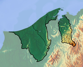
Geography of Brunei
1. Multi-hazard exposure
Brunei has an equatorial climate with high humidity, warm temperatures, and heavy rainfall throughout the year. Its NDC reports average annual rainfall of around 3,000 mm, with rainfall varying from about 2,500 mm annually along the coast to 7,500 mm in the interior. It also notes that mean temperature has increased by 1.25°C since 1970, and that 2019 recorded both the highest daily rainfall and the highest number of forest-fire cases.
The country’s key hazards are mainly hydrometeorological and climate-related rather than tectonic. Brunei’s NDC describes the country as generally free from major natural disasters such as earthquakes and typhoons, but affected by seasonal monsoon rainfall. The main climate-induced disaster categories identified in Brunei’s National Adaptation Plan include forest and bush fires, flash floods and flooding, landslides, fallen trees, and rooftop damage due to strong winds.
2. Flood and urban drainage vulnerability
Flooding is one of Brunei’s most important recurrent climate hazards. The National Adaptation Plan identifies two main forms of flooding: flash floods, which occur within minutes or hours due to intense rainfall, and slow-onset flooding, which develops over hours or days due to prolonged rainfall, river overflow, or tides. It further identifies river floodplain flooding, tidal flooding, and localized flooding caused by drainage obstruction or inadequate culverts and bridges.
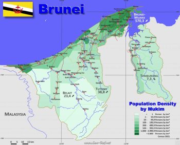
Flood risk is spatially differentiated. Belait and Tutong districts are prone to river floodplain flooding, Temburong is likely to experience tidal flooding, and Brunei-Muara has recorded the highest number of flood cases, partly because it is the most urbanized district and rapid development can overwhelm drainage systems. In remote parts of Belait, floods can last longer because of limited access, long travel distances from emergency services, and occasional reliance on river transport, reinforcing the importance of community preparedness.
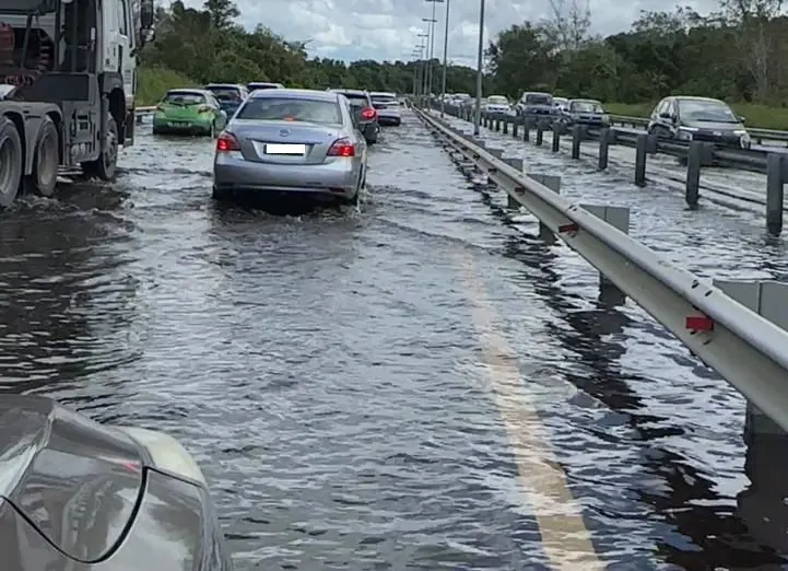
Flooding causes long traffic queues along Brunei’s Muara–Tutong Highway

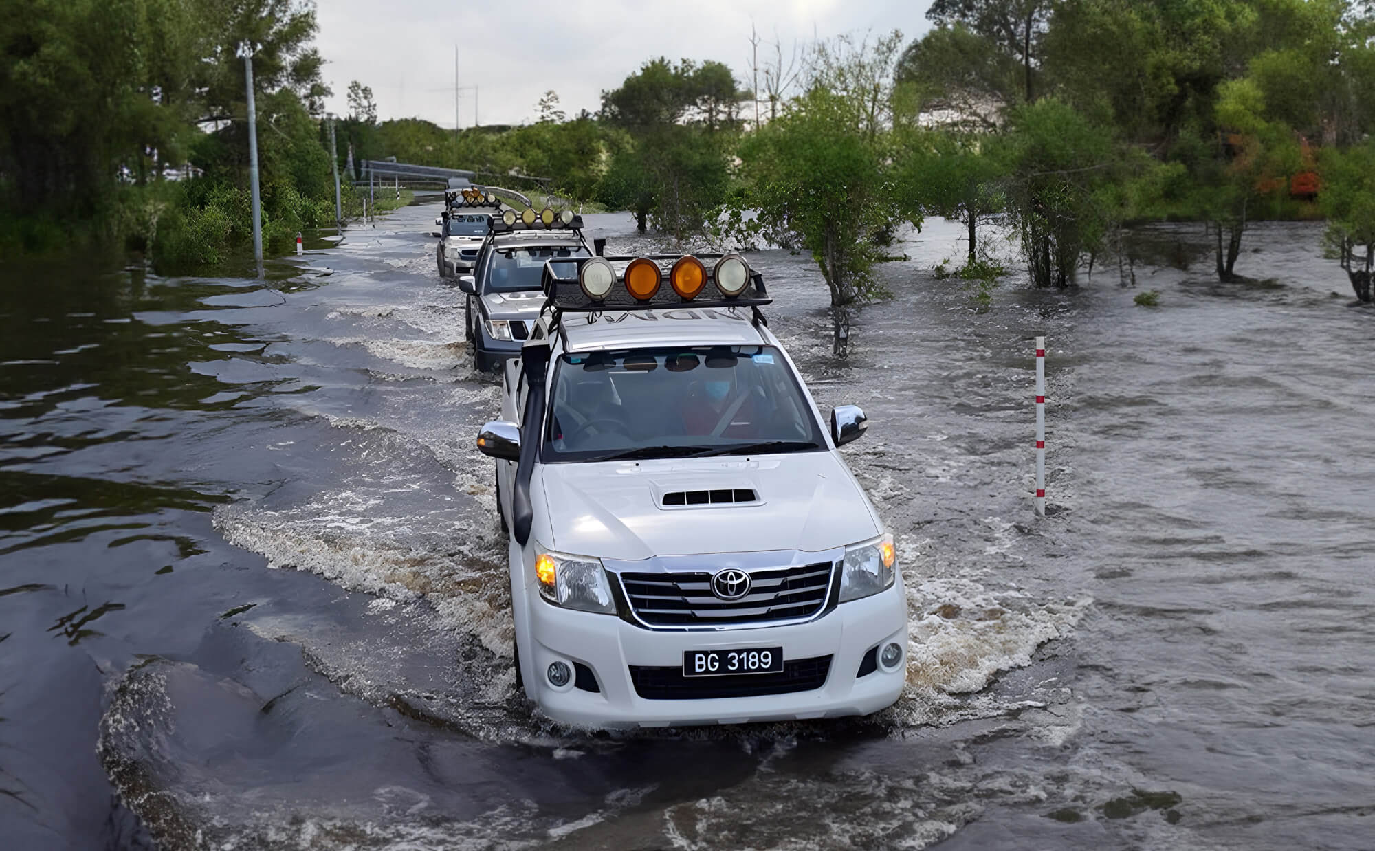
Flash floods inundate Brunei, Temburong district worst-hit
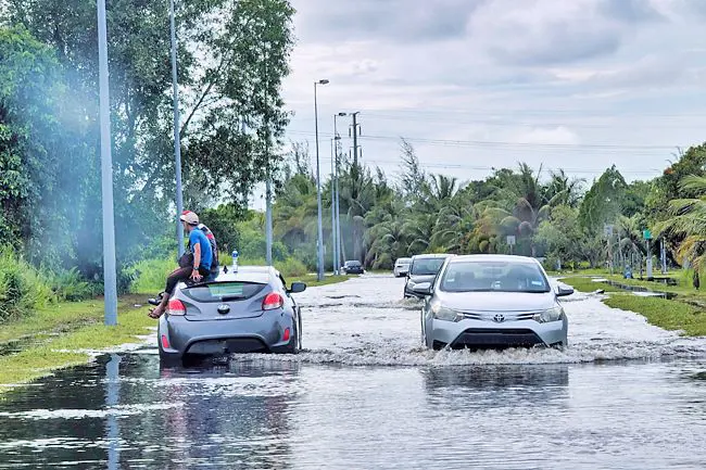
Heavy flooding hits Brunei’s Belait districts after overnight rainfall

Seria is a very vulnerable area for flooding
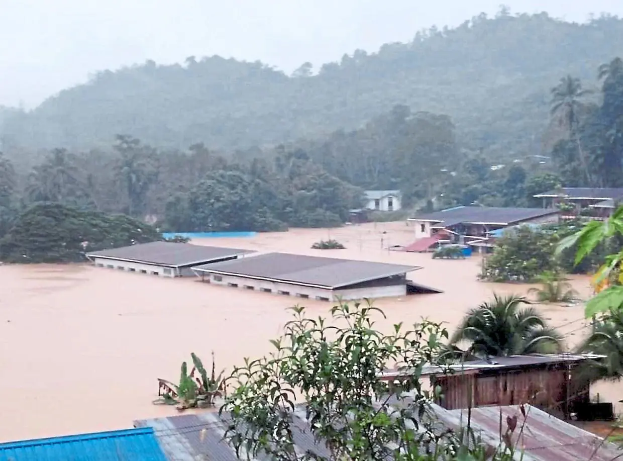
Paitan hit hardest by floods -Homes and buildings in Paitan submerged under floodwaters following heavy rain.
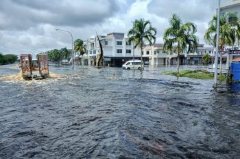
Main road into Senadin inundated by floodwater this morning.
3. Coastal vulnerability and sea-level rise
Coastal risk is a major long-term concern for Brunei Darussalam. The National Adaptation Plan reports that the country protects a 130-km coastline, with over 57 km safeguarded through measures such as sand nourishment, coastal barriers, seawalls, and headlands. It also notes that flood mitigation measures include retention and detention ponds, pump stations, levees, bunds, and tidal barriers.
Despite these measures, Brunei’s coastline has faced erosion for many years, ranging from beach loss to cliff erosion, threatening residents, infrastructure, and economic hubs along the coast. The National Adaptation Plan reports that sea level is increasing by about 5.0–5.5 mm per year, with sea-level rise projected at around 0.44–0.45 m by the end of the 21st century; it also identifies Belait as potentially the most impacted district, with additional concern from land subsidence estimated at 30 mm per year.
4. Forest fire, haze, and drought vulnerability
Forest and bush fires are an important hazard, especially during hotter and drier El Niño periods. Brunei’s National Adaptation Plan notes that forest and bush fires became evident in 2016 and 2019, both El Niño years, and that peat swamp forest fires in Belait are linked to dried-out peat conditions caused by lowered water tables around industrial and residential infrastructure.
Fire and haze risks have cascading effects on public health, transport safety, biodiversity, tourism, agriculture, and air quality. The NAP’s hazard register links increased temperature and drought with forest fire, haze, dehydration, heat-related illness, cardiovascular disease, poor air quality, forest loss, crop damage, pest and disease outbreaks, unreliable utilities, and infrastructure design stress.
5. Landslide and strong-wind vulnerability
Landslides are less frequent than floods but still significant in developed and sloping areas. Brunei’s NAP notes that landslide incidents mainly occur in developed areas, especially Brunei-Muara, where public and private properties are located near slopes affected by soil erosion and ground movement. Continuous monsoon rainfall can further destabilize slopes by saturating loose soil.
Strong winds during monsoon conditions can also cause fallen trees and rooftop damage, particularly where aging infrastructure, exposed settlements, and storm surges interact.
6. Sector-specific vulnerabilities
| Sector | Main climate and hazard risks |
|---|---|
| Urban settlements and infrastructure | Flash floods, drainage failure, landslides, strong winds, road disruption, service interruption |
| Coastal zones | Sea-level rise, coastal erosion, tidal flooding, saltwater intrusion, storm surge, infrastructure exposure |
| Water resources | Flood contamination, drought stress, saltwater intrusion, groundwater depletion, water scarcity |
| Agriculture and food security | Heat stress, pests, plant diseases, drought stress, soil erosion, crop failure, irrigation challenges |
| Fisheries and aquaculture | Sea-surface warming, ocean acidification, salinity change, damaged fishing infrastructure |
| Forests and biodiversity | Forest fires, haze, drought, habitat loss, pest and disease outbreaks, biodiversity loss |
| Health and livelihoods | Heat illness, dengue and vector-borne disease, waterborne disease, disrupted medical access |
| Energy and economy | Infrastructure exposure, supply disruption, coastal asset risk, dependence on oil and gas systems |
Agriculture and food security are particularly sensitive to temperature and rainfall changes. Brunei’s NAP notes that elevated temperatures can accelerate pest life cycles, changing humidity and rainfall can increase plant diseases, reduced or unpredictable rainfall can induce drought stress and reduce yields, and erratic precipitation can complicate irrigation and increase soil erosion. Fisheries and aquaculture are also vulnerable to rising sea-surface temperatures, ocean acidification, salinity change, disrupted habitats, and damage to fishing and aquaculture infrastructure.
7. Health and social vulnerability
Brunei has relatively strong public services, but climate change still creates health and livelihood risks. The NAP states that rising temperatures can worsen heat-related illness, affect vector-borne diseases such as dengue, and that changing rainfall patterns can affect water quality and sanitation, increasing waterborne disease risks. Extreme weather can also damage health infrastructure, disrupt medical services, and limit access to care.
The most vulnerable groups include people living in flood-prone or low-lying areas, coastal communities, residents near unstable slopes, people exposed to haze and poor air quality, older persons, children, outdoor workers, lower-income households, remote communities with limited road access, and people whose livelihoods depend on agriculture, fisheries, forests, or small businesses.
8. Priority resilience needs
Brunei Darussalam’s resilience agenda should prioritize multi-hazard early warning systems, urban flood management, coastal protection, sea-level-rise monitoring, drainage upgrading, river-basin and catchment management, peatland fire prevention, haze preparedness, slope stabilization, climate-resilient infrastructure, water-security planning, climate-smart agriculture, fisheries resilience, ecosystem-based adaptation, health surveillance, and community preparedness.
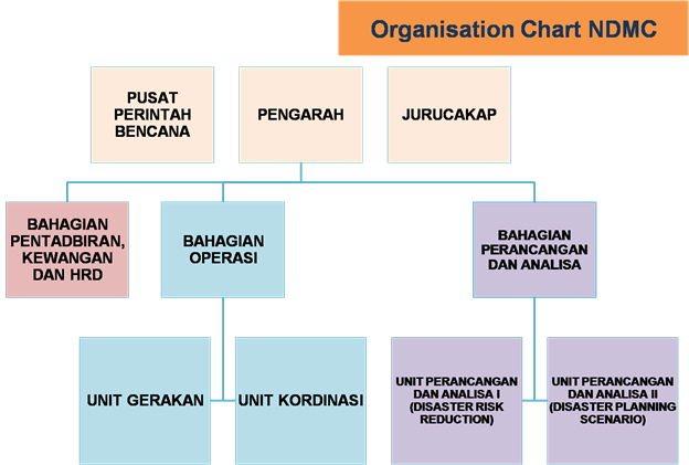
National Disaster Management Centre (NDMC) : Brunei Darussalam

TINDAKAN MENGHADAPI BANJIR
APA PERLU DIBUATKetahui tempat-tempat penempatan sementara.Simpan air minum dalam kontena bersih dan bekalan pertolongan kecemasan. Simpan dokumen-dokumen penting. Sentiasa mengambil maklum melalui radio, televisyen mengenai keadaan cuaca dan amaran banjir.
SEMASA BANJIRPergi ke kawasan yang lebih tinggi dan selamat.Jika air semakin naik tolong matikan semua peralatan elektrik.Jangan bermain air banjir kerana kemungkinan ada bahaya seperti sengatan binatang, penyakit, aliran kejutan elektrik dan sebagainya.Jangan cuba menyeberangi sunai atau longkang yang beraliran deras.Jika kenderaan terhenti, tinggalkan tempat itu serta-merta dan cari tempat selamat.Hubungi 995 untuk Jabatan Bomba dan Penyelamat untuk meminta bantuan dan ikuti perkembangan terkini.
SESUDAH BANJIRKembali ke rumah apabila sudah diumumkan selamat. Jangan terus masuk ke dalam rumah sehingga semuanya dipastikan selamat daripada bahaya.Gunakan air bersih. Beri bantuan untuk menyusun kembali barang-barang yang dipindahkan.
HINDARI PERKARA BERIKUT:-Jangan meminum air banjir.Jangan menyentuh mana-mana kabel atau wayar elektrik yang jatuh.Jangan dibiarkan kanak-kanak bermain berhampiran longkang atau sungai.
JIKA BISKITA BERADA DI DALAM KENDERAANBerjaga-jaga terhadap tanda-tanda banjir dan sentiasa mengikut arahan pihak berkuasa.Elakkan memandu ke kawasan jalan yang dilanda banjir jika kurang pasti kedalamannya.Jika kenderaan biskita terhenti di kawasan banjir segera tinggalkan dan pergi ke kawasan yang lebih tinggi dan selamat.Jangan memandu melalui air banjir yang deras kerana boleh membahayakan biskita.Hubungi 995 untuk Jabatan Bomba dan Penyelamat atau 993 untuk Pasukan Polis Diraja Brunei jika memerlukan bantuan.Beri isyarat kecemasan seperti melambai atau berteriak.
JIKA BERADA DI ATAS JALAN RAYAIkut panduan papan tanda dan amaran paras air banjir.Tunggu di tempat tinggi atau tempat tidak ditenggelami air sehingga penyelamat sampai ke tempat kejadian.Sila hubungi 140 untuk Pusat Pemedulian Pelanggan Jabatan Kerja Raya dan 995 untuk Jabatan Bomba dan Penyelamat bagi melaporkan kejadian banjir.
Nadi atau pusat penyelarasan, arahan dan kawalan, serta komunikasi bagi sumber maklumat bencana di seluruh Negara dan serantau;
Akan mengambil alih perintah dan kawalan District Emergency Operation Centre (DEOC) jika sumber dan kapasiti operasi di luar kemampuannya tahap daerah;
Duty Staff officer (DSO) akan menjalankan tugas memantau kejadian bencana dengan dibantu oleh DCC Watch Keeper yang mengetuai pasukan yang bertugas mengikut jadual harian yang ditetapkan.
Despite the notion of Southeast Asia being a hazard and disaster hotspot and Brunei Darussalam being perceived as a low hazard risk country, this perception is somewhat counteracted because Brunei has its own series of hazard occurrences. An example is the occurrences of small-scale but cumulatively destructive floods.
Flooding and landslides are the most frequent natural hazards that occur annually in the country and are common during the northeast monsoon, generally from October to January. December and January are the wettest months and generally see high-intensity rainfall that can cause flash floods in low-lying areas as well as flooding in floodplain areas, particularly in the major catchments in the Tutong and Belait Districts, these floodplain inundations normally recede after about two weeks. The occurrences of continuous rainfall is also one of the trigger factors for landslides. Although Brunei is not in the typhoon-belt zone, strong winds can occur regularly due to the tail-end effect of typhoon activities during the southwest monsoon. Strong winds are also common during cold surges and heavy thunderstorms.
In Brunei Darussalam, two types of flooding are observed: slow onset and flash floods with minimum or little mud debris. The interior regions of the country, which consist of alluvial plains, are prone to seasonal flooding (slow onset) during monsoon seasons.
Landslides are infrequent but mainly occur in developed areas, affecting public and private properties situated within sloping proximity due to soil erosion and ground movement. Mud and loose soil from terraced hills cause damage to houses and buildings in immediate proximity, which have lead to few fatalities reported. Debris clearance, temporary relocation, and slope stabilizing projects such as retaining wall measures are taken to mitigate these damages.
Elevated temperatures and drier spells related to more variable rainy seasons indicate that experience of forest fires of Brunei will increase in the coming decades as climate change effects take hold. Brunei has witnessed an increased number of forest fires during dry seasons in recent years. The Brunei Fire and Rescue Department (BFRD) recorded a total of 1,116 incidents of forest and grass fires in 2015 alone. More recently, BFRD reported more than 550 forest and bushfires in 2021 with a total of about 300 hectares of land affected. Fire intensity can be exacerbated by strong dry winds that lead to uncontrollable fire spread. In most cases, a forest fire in Brunei is a “ground fire” because of the consistent burning of peat soil rich in organic contents. Fire in peat soils burns and spreads slowly in comparison to dried leaves, woods, or branches of trees. Ground fires damage the ground cover of the forest floor and decrease the nutrients available in the soil that take hundreds of years to build up.
Like many other coastal regions, Brunei Darussalam is still susceptible to strong seasonal winds and storm surges, especially during the Inter-Monsoon seasons. The Inter-Monsoon seasons typically occur between November and March which, according to the Brunei Darussalam Meteorological Department (BDMD) can bring strong northeasterly winds of up to 37 km/h, Brunei Darussalam can experience strong winds, particularly along its northern coast. However, Brunei Darussalam is still located in a region that is vulnerable to the effects of climate change causing more frequent and severe weather events. Brunei Darussalam could become more susceptible to these hazards in the future if climate change continues to exacerbate extreme weather patterns.
Operations Division
| Liaison and coordination of operational actions with related agencies. Responsible for the Disaster Command Center (DCC) which operates 24 hours; DCC tasks are based on the Incident Command System (ICS) as per NaSOP; Two main functions:- | |
| Movement Unit Plan and conduct periodic practical exercises to test the level of preparedness of agencies in facing disasters; Testing existing SOPs to strengthen joint operational actions; Collect disaster teachings and exercises for the purpose of strengthening any SOPs; Identify training needs based on operational experience and teaching during disaster training; Manage and train emergency initial assessment teams; Ensure that all parties involved in joint operations implement their respective NaSOPs and SOPs; Ensure that all parties related to disaster management prepare, update and apply their respective SOPs in acting during joint operations; Ensure all operational actions run smoothly as planned, and; Coordinate the movement of local and foreign initial assessment teams. | Coordination Unit – Ensure that all actions at the scene are coordinated during joint operations. – Among the tasks are as follows:-Improve and strengthen the preparedness of all agencies to handle all types of disasters; Monitor and control the movement of assets used in disaster operations including human resources, vehicles, logistical assets, etc., as well as victims and affected residents; Provide a complete inventory and logistics system that shows the current location and status of all resources and is updated from time to time. Anticipate, prepare and coordinate logistical requirements either in the Central Reserve or in agencies to be deployed during joint operational actions; Maintain a storage system that shows the status of all deployed assets; Prepare and update the list and database of ‘earmarked assets’ of the Centre and also government agencies and the private sector for use in disaster operations including a list of experts; and, Improve and strengthen capabilities in terms of equipment and tools, etc. so that the response measures taken are consistent and effective. |
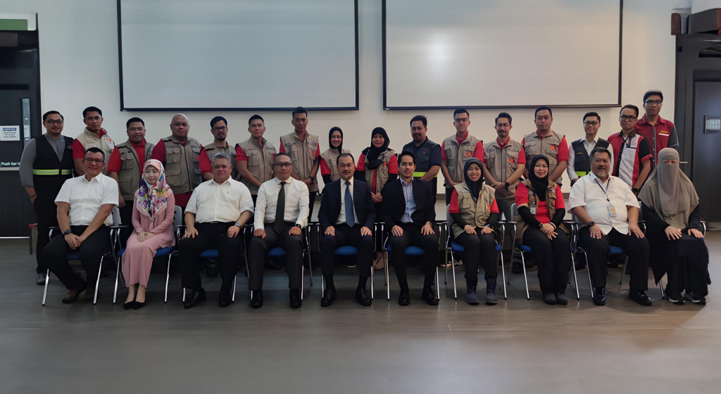
The NDMC with ASEAN-ERAT Members from Brunei Darussalam
Download Documents on Brunei Darussalam
https://drive.google.com/drive/folders/1fNTmXHkiGYOm9xtn7zZs19mNHxJijLoJ?usp=drive_link
====================================================================
An appeal to National Disaster Management Centre (NDMC), Brunei Darussalam
Dear Sir,
Greetings from the Multi-hazard Early Warning System Design &
Implementation Center (MHEWC).
MHEWC provides technical solutions to strengthen Disaster Risk
Management (DRM) governance systems. We would like to offer our support
to the National Disaster Management Centre (NDMC), Brunei Darussalam, in
the following areas:
a) Upgrading the existing web portal into a geospatial, database- and
app-enabled Decision Support System (DSS).
b) Conducting multi-hazard risk assessments; producing geospatial hazard
and risk maps; and establishing and managing a centralized repository
and database management system.
c) Assessing existing monitoring and observation capacities and
supporting NDMC in the installation and enhancement of observation
networks, including automatic data ingestion into a real-time DSS, ICT
enablement, and a data-driven hazard detection and warning mechanism
from national to last-mile levels.
d) Reviewing and upgrading multi-hazard preparedness, response, and
recovery plans across administrative levels and priority sectors.
e) Providing additional technical assistance as required by NDMC.
We would welcome the opportunity to discuss NDMC’s priorities and
propose an implementation roadmap.
We look forward to your kind response.
Sincerely,
Z M Sajjadul Islam
Director
Multi-hazard Early Warning Design and Implementation Center (MHEWC)
Web: mhewc.org
Phone & WhatsApp: +88 01711 979179
Email : zmsajjad@gmail.com