Riesgos climáticos y vulnerabilidades de Colombia – Climate risk and vulnerabilities of Colombia
Climate risk and vulnerabilities of Colombia
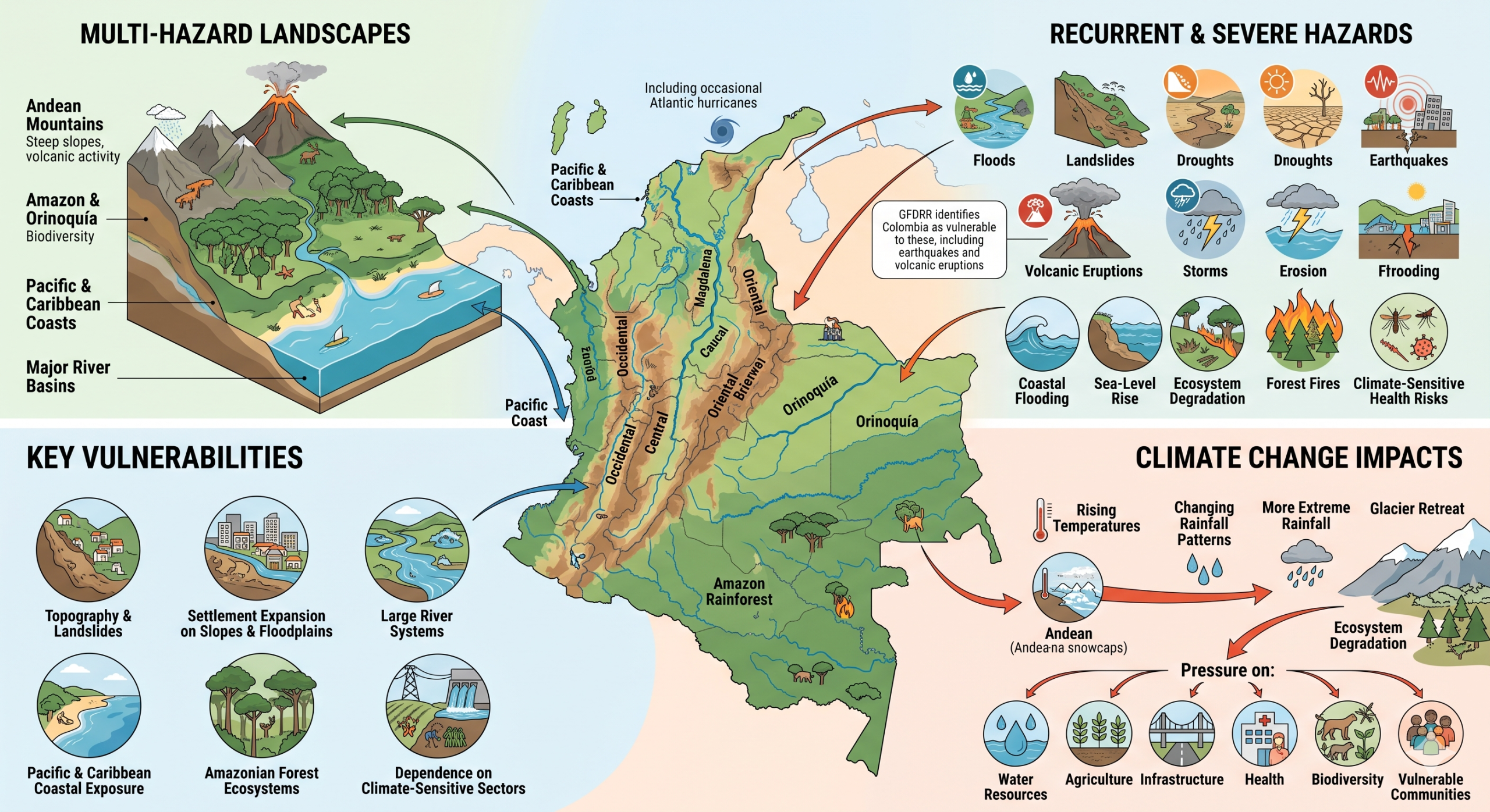
Colombia is exposed to a complex climate and multi-hazard risk profile shaped by its Andean mountain systems, Amazon and Orinoquía regions, Pacific and Caribbean coastlines, major river basins, high biodiversity, rapid urbanization, and exposure to both hydrometeorological and geophysical hazards. The country faces recurrent risks from floods, landslides, droughts, earthquakes, volcanic eruptions, storms, coastal flooding, sea-level rise, erosion, ecosystem degradation, forest fires, and climate-sensitive health risks. GFDRR identifies Colombia as vulnerable to floods, landslides, earthquakes, volcanic eruptions, and occasional Atlantic hurricanes. (gfdrr.org)
Colombia is highly vulnerable to climate change and multi-hazard risks due to its exposure to floods, landslides, droughts, earthquakes, volcanic eruptions, storms, coastal flooding, sea-level rise, and ecosystem degradation. Its mountainous topography, settlement expansion on steep slopes and floodplains, large river systems, Pacific and Caribbean coastal exposure, Amazonian forest ecosystems, and dependence on climate-sensitive sectors increase the scale and complexity of risk. Climate change is expected to intensify these vulnerabilities through rising temperatures, changing rainfall patterns, more extreme rainfall, riverine and coastal flooding, drought stress, glacier retreat, ecosystem degradation, forest fires, and increasing pressure on water resources, agriculture, infrastructure, health, biodiversity, and vulnerable communities.


1. Multi-hazard exposure
Colombia’s hazard profile combines hydrometeorological, geological, and ecosystem-related risks. Floods and landslides are among the most frequent and damaging hazards, especially in the Andean region, river valleys, steep slopes, and urban areas where settlements, roads, and infrastructure are exposed to intense rainfall and unstable terrain. Colombia is also exposed to earthquakes and volcanic eruptions because of its tectonic and volcanic setting. The OECD notes that Colombia is exposed to earthquakes, volcanic eruptions, floods, droughts, and storms across much of the country. (OECD)

2. Climate change as a risk multiplier
Climate change is expected to increase the frequency and intensity of riverine and coastal floods, while more extreme rainfall can generate localized flooding, flash floods, and landslides. The lower basins and valleys of major rivers, including the Magdalena, Cauca, Sinú, Atrato, and Putumayo, are highly susceptible to flooding, while the Pacific and Caribbean coasts are vulnerable to coastal flooding linked to rising seas and storm surges. (dicf.unepgrid.ch)
Climate change also increases drought stress, water-security risks, agricultural losses, heat exposure, ecosystem degradation, and forest-fire conditions. These risks are especially important because Colombia’s development depends heavily on water resources, hydropower, agriculture, biodiversity, forests, transport corridors, and urban infrastructure.
3. Key vulnerabilities
Flood and landslide vulnerability:
Floods and landslides are major recurrent risks in Colombia. High rainfall, steep Andean slopes, deforestation, soil erosion, informal settlements, poor drainage, and settlement growth in hazard-prone areas increase vulnerability. These hazards can damage housing, roads, bridges, schools, health facilities, water systems, and agricultural land.
Drought and water-security vulnerability:
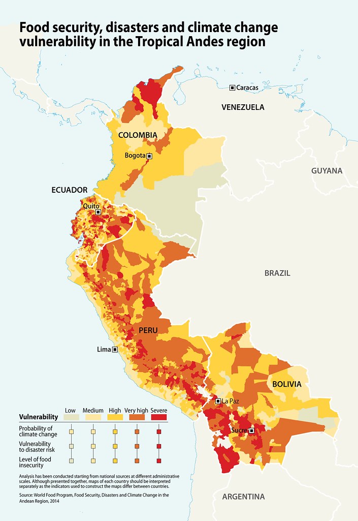
Drought risk affects agriculture, water supply, hydropower, ecosystems, river transport, and rural livelihoods. Climate variability associated with El Niño and La Niña can intensify droughts and floods, creating alternating water-scarcity and flood-risk pressures across different regions.
Agriculture and rural livelihoods:
Colombia’s agriculture is exposed to rainfall variability, drought, floods, landslides, pests, diseases, soil degradation, and changing growing conditions. Smallholder farmers, Indigenous communities, Afro-descendant communities, rural workers, and households dependent on climate-sensitive livelihoods are particularly vulnerable.
Coastal and island vulnerability:
Colombia’s Pacific and Caribbean coasts face sea-level rise, coastal erosion, coastal flooding, storm surge, saltwater intrusion, ecosystem loss, and risks to tourism, fisheries, ports, coastal settlements, and mangroves. Coastal communities with limited infrastructure and livelihood alternatives face heightened exposure.
Amazon, forests, and biodiversity:
Colombia is one of the world’s most biodiverse countries, and its forests and ecosystems are critical for water regulation, carbon storage, disaster-risk reduction, and livelihoods. Deforestation, land grabbing, forest fires, drought, and climate change increase ecosystem vulnerability. In 2024, Colombia’s deforestation reportedly rose by 43%, with the Amazon accounting for more than 65% of forest loss, driven by fires, drought, land grabbing, livestock expansion, illegal roads, and illicit crops. (Reuters)
Urban vulnerability:
Urban areas such as Bogotá, Medellín, Cali, Barranquilla, Cartagena, and other cities face risks from flooding, landslides, heat stress, water shortages, poor drainage, informal settlements, and exposed transport systems. Hillside settlements are particularly vulnerable to landslides and flooding; recent reporting on Medellín highlights how hillside informal settlements have developed local adaptation actions such as rainwater harvesting, reforestation, eco-gardens, and water-management systems. (The Guardian)
4. Sector-specific risk summary
| Sector | Main climate and hazard risks |
|---|---|
| Water resources | Drought, flood contamination, river variability, glacier retreat, watershed degradation |
| Agriculture and food security | Drought, floods, landslides, pests, diseases, soil erosion, crop losses |
| Urban settlements | Flooding, landslides, poor drainage, informal settlement exposure, heat stress |
| Transport infrastructure | Road washouts, slope failure, bridge damage, river flooding, landslide disruption |
| Coastal zones | Sea-level rise, coastal erosion, storm surge, saltwater intrusion, coastal flooding |
| Forests and biodiversity | Deforestation, fire, drought stress, ecosystem degradation, biodiversity loss |
| Health | Heat stress, vector-borne disease, waterborne disease, disaster-related service disruption |
| Energy | Hydropower variability, drought impacts on reservoirs, infrastructure exposure |
5. Social vulnerability
The most vulnerable groups include low-income urban households, informal settlers, rural communities, smallholder farmers, Indigenous peoples, Afro-descendant communities, women-headed households, children, older persons, people with disabilities, displaced populations, and communities living on unstable slopes, floodplains, coastal zones, or drought-prone areas. Vulnerability is highest where hazard exposure overlaps with poverty, insecure land tenure, weak housing, limited savings, low insurance coverage, and restricted access to early warning, basic services, and recovery support.
6. Priority resilience needs
Colombia’s resilience agenda should prioritize multi-hazard early warning systems, flood and landslide forecasting, drought monitoring, watershed management, climate-resilient agriculture, ecosystem-based adaptation, forest and fire-risk management, coastal-zone adaptation, resilient urban drainage, slope stabilization, seismic and volcanic risk reduction, risk-informed land-use planning, disaster risk financing, and shock-responsive social protection.
Colombia’s National Adaptation Plan aims to reduce national vulnerability and increase response capacity to climate-change threats and impacts. (Minambiente) A strong risk-management approach should therefore connect climate adaptation, disaster risk reduction, territorial planning, infrastructure resilience, ecosystem protection, and locally led adaptation.
Climate Change and Risk Management
Directorate of Climate Change and Risk Management
Its main objective is to develop the necessary technical and operational foundations to advance climate change management in the different sectors and territories of the country, in partnership with public and private actors at the local, national and international levels.
Among its main functions is to provide the technical elements required for the development of public policies, plans, projects and programs on climate change, with a low-carbon approach that will strengthen the country’s development.
Additionally, it establishes guidelines for preventing ecological risk in coordination with the entities that comprise the National System for Disaster Prevention and Response. It guides the assessment of the vulnerability impacts on biodiversity and its ecosystem services due to the effects of climate change, among other factors.
Climate Change and Risk Management – Documents
Guides
Guide to Climate Change Considerations for Land Use Planning
No. 1 Published: May 30, 2024
August 5, 2022, “Through which the Guide for the formulation and implementation of the Comprehensive Territorial Climate Change Management Plans –PIGCCTis established .”
No. 2 Published: October 31, 2022
No. 3 Published: October 31, 2022
No. 4 Published: October 31, 2022
Guide to empowered territories for climate action
No. 5 Published: December 6, 2021

Mission
IDIGER undertakes actions and generates guidelines for disaster risk management and adaptation to climate change, within the framework of the SDGR-CC coordination in the Capital District, in order to protect people at risk and achieve the sustainable development of Bogotá DC
Vision
By 2030, the District will have better capabilities to manage disaster risk and the effects of climate change, through territorial intervention and effective coordination of the SDGR-CC by IDIGER, for the construction of a resilient city.
Strategic Objectives 2024-2027
1. Generate knowledge of the risk and effects of climate change through the analysis of general and detailed information to define actions for risk reduction, adaptation to climate change and disaster management in the city.
2. Safeguard the lives of families located in high-risk, non-mitigable areas in Bogotá, which were recommended through technical documents and/or judicial rulings to the resettlement program.
3. Increase risk reduction and climate change adaptation actions in the Local Planning Units (UPL) that have risk analysis in the Capital District.
4. Strengthen risk governance and adaptation to climate change through community action.
5. Strengthen institutional, sectoral and community capacities for risk management and adaptation to climate change at the local level.
6. Coordinate and implement actions that promote risk reduction and adaptation to climate change through the management and promotion of Sustainable Urban Drainage Systems (SUDS) as a Nature-Based Solution.
7. Develop sectoral management for the articulation and/or adoption of risk management and climate change planning instruments with climate change reduction and adaptation actions.
8. Optimize logistical, technical, institutional and management capabilities for the proper handling of emergencies or disasters associated with threatening phenomena of diverse origins that occur in Bogotá DC
9. Coordinate the actors of the SDGRCC with guidelines, mechanisms, instruments and spaces for participation, to strengthen knowledge and risk reduction, emergency and disaster management, as well as climate change adaptation measures in the Capital District.
10. Strengthen the implementation of the policies of the integrated planning and management model and the complementary management systems that support the fulfillment of IDIGER’s mission for the effective enjoyment of citizens’ rights.
11. Implement the strategy of service to citizens and stakeholders of IDIGER, providing comprehensive solutions for access to information and improvement in the provision of services, ensuring quality, warmth and timeliness in harmony with the principles of transparency, prevention and fight against corruption.


IDIGER process map
Update to the National Risk Management Plan 2015-2030

The National Disaster Risk Management Plan (PNGRD) “A Development Strategy” 2015-2030, is the country’s roadmap for sectors and territories to coordinate the mobilization of resources and human capital to advance actions to understand, prevent, and reduce risk and manage disaster situations.
In the second update of this instrument, in addition to setting an objective for each of the processes of disaster risk management (risk knowledge, risk reduction and disaster management), we ensure that social and community participation and the strengthening of risk governance become key pieces for advancing effective actions to reduce our risk conditions and face the challenges posed by the adaptation of our territories to the effects of climate change in the coming years.
Decree adopting the second update of the PNGRD 0978 of August 2, 2024
2nd Update National Risk Management Plan 2015 – 2030
WHAT IS THE NATIONAL DISASTER RISK MANAGEMENT PLAN ?
Colombia’s National Disaster Risk Management Plan is a development strategy that serves as a roadmap for the country to convene the various stakeholders of the National Disaster Risk Management System (SNGRD) to implement joint actions for the social process of risk management, contributing to security, improved quality of life, and sustainable development.
The PNGRD was adopted by Presidential Decree 308 of 2016, following a formulation process carried out within the framework of Decree 1081 of 2015 (Chapter 2, Procedure for the Issuance and Updating of the National Disaster Risk Management Plan) and updated by Presidential Decree 1478 of August 3, 2022.
From its general objective and its five specific objectives, Colombia’s National Disaster Risk Management Plan is aligned with the four priorities established in the Sendai Framework 2015-2030:
- Understanding disaster risk
- Strengthen disaster risk governance to manage disaster risk
- Investing in disaster risk reduction for resilience
- Increase disaster preparedness for an effective response, and “build back better” in the areas of recovery, rehabilitation and reconstruction
With the expected objective in the next 15 years: The substantial reduction of disaster risk and losses caused by disasters, both in lives, livelihoods and health, as well as in physical, social, cultural and environmental assets of people, businesses, communities and countries.
HOW IS THE PNGRD ARTICULATED INTO THE
COUNTRY’S DEVELOPMENT PLANNING?
The PNGRD incorporates and aims to align with the Sustainable Development Goals and climate change adaptation. The fundamental goal shared by disaster risk management and climate change adaptation is to reduce disaster risk and the associated losses and damages resulting from climatic, hydrological, and socio-natural events, with potential increases in the intensity and frequency of future extreme events exacerbated by the effects of global warming.
To this end, it defines programs and projects that address the following strategic lines related to these themes:
- Synergies between adaptation and mitigation
- Socio-ecosystem-based adaptation
- Integration of climate change adaptation and risk management, including the design and implementation of an early warning system
- Adaptation of basic infrastructure and sectors of the economy
- Incorporation of adaptation and resilience considerations into sectoral, territorial and development planning
- Promoting climate change education to generate behavioral changes.
All of this is aimed at reducing vulnerability and increasing the resilience of communities through mitigation and adaptation measures.
WHAT ARE THE APPROACHES AND OBJECTIVES OF THE PNGRD?


WHAT ARE THE GOALS OF THE PNGRD BY 2030?
- Reduce the number of deaths nationwide caused by unintentional anthropogenic natural events (hereinafter simply events) by 2030 and reduce the national death rate caused by events to 3.5 people per 100,000 inhabitants in the period 2015-2030, compared to the decade 2005-2014.
Definition: Refers to the number of confirmed deaths or people missing or presumed dead in an event or after the impact of an event.
- Reduce the number of people affected in the country by 2030 and reduce the rate of people affected by events to 6,215 people per 100,000 inhabitants in the period 2015-2030, compared to the decade 2005-2014.
Definition: Refers to the number of people affected in their property, infrastructure and/or livelihoods in an event or after the impact of an event. - Reduce the number of homes destroyed directly by recurring events in the period 2015-2030 compared to the decade 2005-2014.
Definition: Refers to the number of homes destroyed in a recurring event or after the impact caused by a recurring event (Floods, Landslides, Flash Floods) - Reduce the number of school buildings affected by events in the period 2015-2030 compared to the decade 2005-2014
Definition: Refers to the number of school buildings affected by an event or after the impact caused by a recurring event (Floods, Mass Movements, Flash Floods). - Reduce damage caused by events to drinking water services in the period 2015-2030 compared to the decade 2005-2014.
Definition: Refers to the number of aqueducts affected in an event or after the impact of a recurring event (Floods, Mass Movements, Flash Floods).
HOW IS THE PROGRAMMATIC COMPONENT STRUCTURED?
The programmatic and investment component of the PNGRD defines, for each of the formulated strategies, the programs and investment projects, indicating their objectives and goals, those responsible for their implementation, as well as the sources of financing and the resources allocated for this purpose in the short, medium, and long term. The PNGRD’s implementation period spans three constitutional government terms, allowing for its alignment with the respective development plans implemented for the 2015-2030 period.Twenty-three sectors participated in defining the programmatic component, validating the information, and it is expected that the defined goals and programs will be incorporated into their short-, medium-, and long-term action plans. The participating sectors, with 49 affiliated, linked, and strategic allied entities, were the following: 1) Interior, 2) Foreign Affairs, 3) Finance and Public Credit, 4) Justice and Law, 5) National Defense, 6) Agriculture, Fisheries, and Rural Development, 7) Health and Social Protection, 8) Labor, 9) Mining and Energy, 10) Commerce, Industry, and Tourism, 11) National Education, 12) Environment and Sustainable Development, 13) Housing, City, and Territory, 14) Information and Communication Technologies, 15) Transportation, 16) Culture, Recreation, and Sports, 17) Presidency of the Republic, 18) National Planning Department (DNP), 19) Public Service, 20) Social Inclusion and Reconciliation, 21) Statistical Information, 22) Sports Administration, and 23) Science and Technology. Similarly, territorial entities such as departments and municipalities participated.The National Disaster Risk Management Plan will have funding resources to implement and fulfill its general and programmatic components, aiming to achieve sectoral impact on the execution of projects at the national and territorial levels. To this end, national, regional, departmental, district, and municipal entities that are part of the National System must include in their annual budgets the necessary budget allocations for carrying out their responsibilities regarding risk assessment and reduction, and disaster management (Article 53, Law 1523/2012). These allocations will be guided by the projects proposed and agreed upon in the programmatic component of the National Disaster Risk Management Plan for the short, medium, and long term.
MONITORING AND EVALUATION OF THE PNGRD
In accordance with the provisions of Decree 1478 of 2022, which adopts the first update of the 2015-2030 National Disaster Risk Management Plan (PNGDR), Article 1 states that the National Unit for Disaster Risk Management will be responsible for monitoring the PNGRD through an annual report based on progress information provided by each of the government sectors with responsibilities in the PNGRD, the National Disaster Risk Management Committees, and the Territorial Disaster Risk Management Councils.Likewise, the monitoring and evaluation must present the progress in achieving the objectives, goals, and budget execution of the projects. The monitoring andevaluation of the plan must constitute a tool for continuous improvement that clearly and realistically presents the actions of the government and society in general in integrating disaster risk management as an element of development, quality of life, and territorial security through a national planning instrument.
First report: monitoring and evaluation – PNGRD
Second report: monitoring and evaluation – PNGRD
Third report: monitoring and evaluation – PNGRD
Fourth report: monitoring and evaluation – PNGRD
Fifth report: monitoring and evaluation – PNGRD
Sixth report: monitoring and evaluation – PNGRD
VII report: monitoring and evaluation – PNGRD
VIII report: monitoring and evaluation – PNGRD
IX report: monitoring and evaluation – PNGRD
X report: monitoring and evaluation – PNGRD
XI report: monitoring and evaluation – PNGRD
XII report: monitoring and evaluation – PNGRD
XIII report: monitoring and evaluation – PNGRD
XIV report: monitoring and evaluation – PNGRD
XV report: monitoring and evaluation – PNGRD
PNGRD Executive Report August 2024
XVI Monitoring Report to the PNGRD
Executive Report PNGRD August 2025
Monitoring of disaster risk management actions by territorial and sectoral actors – SIPNGRD Annual Report
As part of the National Disaster Risk Management System, territorial entities (32 departments and 1,102 municipalities) and national sectors contribute to the development of this Plan by implementing projects aimed at risk assessment, prospective and corrective risk reduction, and disaster management from the preparedness phase to emergency response, all within a framework of institutional and community strengthening.
At the local level, the Departmental and Municipal Offices of Disaster Risk Management, as leaders of their Territorial Councils established for this purpose, coordinate all information related to the National Disaster Risk Management Plan (PNGDR) (2015-2030) through their respective administrations (government cabinet secretariats, operational entities, and environmental and health authorities). Similarly, the Ministries lead this sectoral report and coordinate it jointly with their affiliated and associated entities.
Considering the above, the annual Monitoring and Evaluation Report for the National Disaster Risk Management Plan (PNGNDR) is compiled based on the execution and reporting of the actions projected in the short, medium, and long term within the PNGRD. Currently, an Information System for the National Disaster Risk Management Plan (SIPNGRD) is available for each stakeholder to report their progress.