Climate risk and vulnerabilities of Ghana
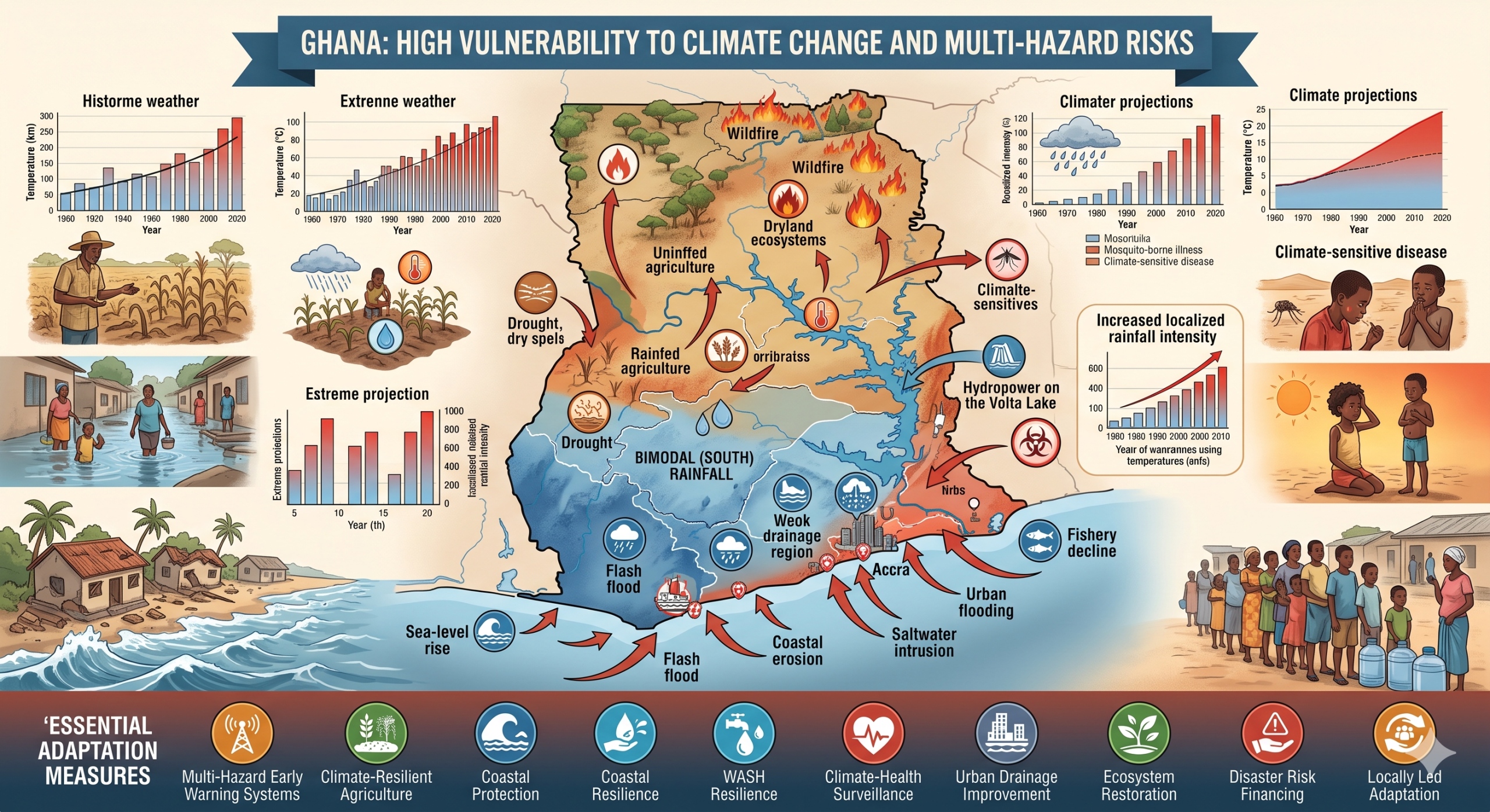
Ghana is highly exposed and vulnerable to climate change and multi-hazard risks due to its dependence on rainfed agriculture, climate-sensitive water resources, exposed coastal settlements, rapid urbanization, weak drainage systems, northern dryland livelihood stress, and reliance on fisheries, forests, hydropower, markets and informal livelihoods. The country faces major risks from floods, flash floods, urban flooding, drought, erratic rainfall, extreme heat, coastal erosion, sea-level rise, saltwater intrusion, wildfires, crop failure, fisheries decline, water stress, food insecurity, climate-sensitive diseases, infrastructure damage and public-finance pressure. Climate change is expected to intensify these vulnerabilities through rising temperatures, more severe dry conditions, heavier localized rainfall, increased flood risk, coastal inundation, reduced agricultural productivity, water-resource stress, public-health risks and growing pressure on vulnerable coastal, rural and urban communities. Strengthening multi-hazard early warning systems, impact-based forecasting, flood and drought risk management, climate-resilient agriculture, coastal protection, WASH resilience, climate-health surveillance, urban drainage improvement, ecosystem restoration, disaster risk financing and locally led adaptation is essential to reduce losses and protect Ghana’s development gains.
Ghana is highly vulnerable to climate change and multi-hazard risks because its economy, food systems, water resources, coastal settlements, fisheries, hydropower, ecosystems, and urban infrastructure are strongly climate-sensitive. The country faces recurrent floods, flash floods, drought, dry spells, extreme heat, coastal erosion, sea-level rise, saltwater intrusion, severe storms, wildfires, crop pests, water stress, food insecurity, climate-sensitive disease risks, and infrastructure disruption. Ghana’s official climate information describes a tropical climate shaped by wet and dry seasons, with bimodal rainfall in the south and unimodal rainfall in the north, creating distinct regional exposure patterns.
1. Multi-hazard exposure
Ghana’s main climate and disaster risks include flooding, drought, coastal erosion, coastal flooding, heatwaves, wildfires, storms, crop pests, water stress, food insecurity and disease outbreaks. A recent disaster-risk-financing framework identifies Ghana’s principal growing risks as floods, droughts, epidemics and coastal erosion, with climate change, rapid urbanization and socio-economic vulnerability increasing losses and fiscal pressure. (UNDP)
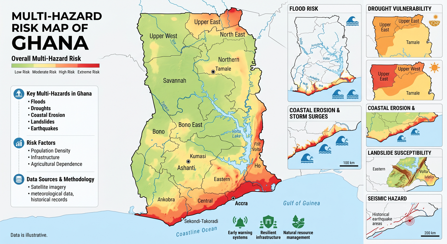
The risk profile differs sharply by geography. Northern Ghana is more exposed to drought, dry spells, erratic rainfall, food insecurity, livestock stress, bushfires and low adaptive capacity. Southern and coastal Ghana, including Accra, Tema, Keta, Ada, Cape Coast, Sekondi-Takoradi and other coastal towns, is highly exposed to urban flooding, sea-level rise, coastal erosion, saltwater intrusion, storm surge and sanitation-related health risks. The Volta, White Volta, Black Volta, Pra, Ankobra and Tano river systems also create riverine-flood and water-resource-management risks.
2. Climate change as a development risk multiplier
Climate change is a major development risk for Ghana because it affects agriculture, water resources, energy, fisheries, coastal settlements, urban infrastructure, health, biodiversity, transport and public finance. The World Bank climate-risk profile projects heightened dry conditions and increasing pressure on water resources by mid-century and notes that Ghana’s agriculture sector is highly vulnerable to climate variability and change. (Climate Change Knowledge Portal)
Ghana’s updated NDC includes 47 adaptation and mitigation programmes of action across 19 policy areas, aiming to build the resilience of more than 38 million people while reducing emissions and generating green jobs. This reflects the cross-sector nature of Ghana’s climate risk, where adaptation is not only an environmental priority but a development, livelihoods, health, infrastructure and public-finance priority. (UNFCCC)
3. Flood, flash-flood and urban vulnerability
Flooding is one of Ghana’s most recurrent and damaging hazards. Heavy rainfall, blocked drains, weak solid-waste management, poor spatial planning, settlement in flood-prone areas, insufficient drainage capacity and river overflow combine to create frequent urban and peri-urban flooding. Accra and other southern cities are particularly exposed because rapid urban growth has increased impervious surfaces, drainage pressure and settlement in flood-prone zones.
Floods damage houses, roads, bridges, schools, clinics, markets, drainage systems, water points, latrines, crops, household assets and small businesses. UNESCO reported that Ghana’s 2023 floods displaced about 35,800 people, illustrating the scale of water-related disaster risk and the need for improved flood forecasting, basin management, early warning and resilient drainage systems. (UNESCO)
4. Drought, dry spells and northern livelihood vulnerability
Drought and dry spells are major hazards, especially in northern Ghana, where livelihoods depend heavily on rainfed agriculture, livestock, forestry resources and seasonal water availability. UNDP notes that vulnerability to drought in Ghana has strong geographic and socio-economic patterns, with the northern regions among the most vulnerable because of low adaptive capacity and heavy dependence on rainfed agriculture and forestry.
Drought affects Ghana through reduced crop yields, livestock stress, lower water availability, food-price increases, reduced household income, bushfire risk, poor nutrition and seasonal migration pressure. UNESCO reported estimated crop revenue losses of US$1.88 billion by the 2024 drought and a 35% reduction in maize production, showing how climate shocks translate directly into food-security and livelihood risks. (UNESCO)
5. Agriculture, food security and rural livelihood vulnerability
Agriculture is one of Ghana’s most climate-sensitive sectors. More than 80% of agricultural production is rainfall-dependent, while only about 2% of irrigation potential is used, making farmers highly exposed to rainfall variability, drought, floods, pests and temperature stress. (PMC)
| Sub-sector | Main climate and hazard risks |
|---|---|
| Rainfed maize, millet, sorghum and rice | Drought, delayed rains, dry spells, floods, heat stress, crop failure |
| Cocoa and tree crops | Heat stress, rainfall shifts, drought, pests, diseases, reduced yields |
| Vegetables and horticulture | Water shortages, floods, pest outbreaks, heat stress, post-harvest losses |
| Livestock | Water scarcity, pasture decline, heat stress, disease, bushfire impacts |
| Fisheries and aquaculture | Coastal erosion, warming waters, lagoon degradation, storm damage, salinity shifts |
| Rural livelihoods | Reduced income, food insecurity, migration pressure, asset depletion |
Cocoa is particularly important because Ghana is a major global producer, and drought and heat stress in Ghana and Côte d’Ivoire have been linked to major cocoa-price shocks. Climate-related disruption in cocoa zones can therefore affect farmer incomes, export earnings, household food security and global commodity markets. (The Guardian)
6. Coastal erosion, sea-level rise and saltwater intrusion
Coastal risk is one of Ghana’s most strategic vulnerabilities. The country’s eastern and central coastline is exposed to coastal erosion, sea-level rise, tidal flooding, saltwater intrusion, storm surge, beach loss, lagoon flooding and damage to coastal infrastructure. Ghana’s national adaptation strategy identifies coastal erosion and saltwater intrusion as major coastal-zone challenges, with the east coast especially affected and communities in Ada, Keta, Ningo and Prampram at risk of losing houses and infrastructure. (UNDP Climate Change Adaptation)
Coastal erosion threatens fishing villages, roads, markets, schools, churches, cemeteries, tourism assets, ports, landing beaches, lagoons and wetlands. In eastern coastal communities such as Keta and Ada, erosion and flooding are not only physical hazards; they create livelihood disruption, cultural loss, displacement pressure and public-health risks for fishing and low-income coastal households.
7. Water resources, hydropower and WASH vulnerability
Water resources in Ghana are vulnerable to drought, rainfall variability, flood contamination, catchment degradation, illegal mining pollution, urban demand growth, irrigation demand and climate-sensitive river flows. The World Bank climate profile notes that basin flows could decline significantly by mid-century, increasing pressure on water allocation, hydropower, irrigation, domestic water supply and ecosystems. (Climate Change Knowledge Portal)
WASH vulnerability is linked to both drought and flood extremes. Drought reduces safe-water availability and hygiene capacity, while floods contaminate wells, drains, latrines, surface water and sanitation systems. This increases risks of diarrhoeal disease, cholera and other waterborne diseases, especially in informal settlements, flood-prone urban areas and rural communities with limited safe-water infrastructure.
8. Heat, wildfire and health vulnerability
Rising temperatures increase heat stress, dehydration, labour-productivity losses, crop water demand, livestock stress, wildfire risk and public-health pressure. Ghana’s official climate information notes strong seasonal temperature patterns, with peak temperatures typically occurring in March, while climate-change assessments identify rising temperatures and changing rainfall as major risks. (Climate Change Knowledge Portal)
Climate change can worsen health risks through heat-related illness, malaria, dengue, cholera, diarrhoeal disease, malnutrition, flood injuries and service disruption. Ghana’s updated climate commitments and adaptation planning recognize health, water, agriculture, infrastructure and coastal zones as key sectors requiring resilience measures. (UNFCCC)
9. Ecosystems, forests, biodiversity and fisheries vulnerability
Ghana’s forests, savannas, wetlands, mangroves, lagoons, river basins and coastal ecosystems are climate-sensitive. Drought and heat can increase forest degradation, bushfire risk and biodiversity stress, while heavy rainfall and floods can accelerate erosion, sedimentation and pollution of rivers and lagoons. Coastal ecosystems are additionally threatened by sea-level rise, erosion, mangrove loss, lagoon salinization and fisheries-habitat degradation.
Fisheries and coastal livelihoods are vulnerable to warming waters, coastal erosion, storm damage, changing fish distribution, lagoon degradation, illegal fishing pressure and reduced landing-site safety. These risks are especially serious for fishing communities along the Gulf of Guinea where livelihoods, food security and cultural identity are closely tied to the sea.
10. Infrastructure, cities and settlement vulnerability
Ghana’s infrastructure risk is high in flood-prone, coastal and rapidly urbanizing areas. Roads, bridges, culverts, markets, schools, clinics, drains, water systems, power assets, ports, coastal roads and informal settlements are exposed to heavy rainfall, poor drainage, flooding, erosion and coastal inundation. The Global Shield gap analysis notes that Ghana’s entire coastal area is vulnerable to coastal erosion and flooding, while several cities in the south are vulnerable to flooding. (The Global Shield against Climate Risks)
Urban vulnerability is particularly important in Accra, Tema, Kumasi, Sekondi-Takoradi, Cape Coast, Koforidua and Tamale, where floods, heat, poor drainage, informal settlement exposure, solid-waste blockage and service pressures can overlap. Flood events in urban areas can rapidly damage livelihoods because traders, transport workers, informal businesses and low-income households often lack insurance and savings.
11. Sector-specific vulnerability summary
| Sector | Main climate and multi-hazard risks |
|---|---|
| Agriculture and food security | Drought, erratic rainfall, floods, heat stress, crop pests, reduced yields, price shocks |
| Water resources | Reduced basin flows, drought, flood contamination, pollution, water-allocation stress |
| Coastal settlements | Coastal erosion, sea-level rise, storm surge, tidal flooding, saltwater intrusion |
| Fisheries and aquaculture | Warming waters, coastal erosion, lagoon degradation, rough seas, fish-stock shifts |
| Health and WASH | Heat stress, malaria, cholera, diarrhoeal disease, flood contamination, malnutrition |
| Urban areas | Flash flooding, poor drainage, informal settlement exposure, heat stress, sanitation failure |
| Infrastructure | Road flooding, bridge damage, drainage failure, coastal road exposure, utility disruption |
| Forests and biodiversity | Wildfire, drought stress, ecosystem degradation, erosion, mangrove and wetland loss |
| Public finance | Disaster response costs, crop losses, infrastructure repair, climate-risk-financing gaps |
12. Social vulnerability
The most vulnerable groups include smallholder farmers, livestock keepers, fishing communities, coastal households, informal urban residents, women-headed households, children, older persons, people with disabilities, low-income households, market traders, and communities in drought-prone northern districts or flood-prone coastal and urban areas.
Vulnerability is highest where climate exposure overlaps with poverty, limited irrigation, weak drainage, poor housing, low savings, limited insurance, unsafe water, insecure land tenure, dependence on rainfed farming or fishing, and limited access to early warning and climate information.
13. Priority resilience needs
Ghana’s resilience agenda should prioritize multi-hazard early warning systems, impact-based forecasting, flood forecasting, drought early warning, climate-resilient agriculture, coastal protection, water-security planning, WASH resilience, health surveillance, urban drainage improvement, ecosystem restoration, disaster risk financing and locally led adaptation.
| Priority area | Key actions |
|---|---|
| Early warning and anticipatory action | Impact-based alerts for floods, drought, heat, coastal flooding, crop stress, disease outbreaks and bushfires |
| Flood-risk management | Urban drainage upgrading, floodplain zoning, basin forecasting, solid-waste control, evacuation planning |
| Drought resilience | Seasonal forecasting, drought contingency plans, water harvesting, irrigation efficiency, drought-tolerant crops |
| Climate-resilient agriculture | Agro-climate advisories, improved seeds, soil moisture conservation, pest surveillance, crop insurance |
| Coastal resilience | Shoreline monitoring, nature-based buffers, mangrove restoration, coastal zoning, protection of fishing settlements |
| Water and WASH security | Watershed protection, safe water systems, flood-safe sanitation, pollution control, groundwater monitoring |
| Health resilience | Heat-health planning, malaria/cholera surveillance, nutrition monitoring, climate-resilient health facilities |
| Risk financing and governance | Contingency funds, insurance, forecast-based financing, social protection, climate-risk screening of public investments |
National Disaster Management Organisation (NADMO)
The Food and Agriculture Organization of the United Nations (FAO) and the National Disaster Management Organisation (NADMO), on 16th September 2025,

Strategic Objectives
- To improve Human and Institutional Capacity.
- To promote Disaster Risk Reduction (DRR) and Climate Change Risk Management through the establishment of National and Regional Platforms for all Stakeholders.
- To strengthen Disaster Prevention and Response Mechanisms.
- To link NADMO’s Disaster Prevention and Management Programmes to the GPRS and re-afforestation through effective social mobilisation for disaster prevention and poverty reduction.
General Objectives
Disaster Management Objectives
In the 1980’s, it was observed that the number of disasters and their impacts were increasing worldwide. This situation alarmed the United Nation Organisation which held various conferences on the issue, leading to the UN declaration of GAD 44/236 of 1989 declaring the 1990’s as the International Decade for Natural Disaster Reduction (IDNDR).
This was followed by the conference on Natural Disaster Reduction held in Yokohama, Japan in May 1994. The conference established the International Strategy for Disaster Reduction (ISDR) to replace the defunct IDNDR. The Yokohama strategy for a safe world and its plan of action mandated each country to establish a permanent disaster management organization.
In response to the Yokohama strategy for a safer world and plan of action, the National Disaster Management Organization (NADMO) was established by act 517 of 1996 to manage disasters and similar emergencies in the country.
It was structured and placed under the ministry of the interior, to enable it coordinate all the relevant civil authorities at the national, regional and district levels. NADMO functions under a National secretariat, ten (10) Regional secretariats, two hundred and forty-three (243) Metropolitan, Municipal and District secretariat and over nine hundred (900) Zonal offices throughout the country.
Our Yearly Activities

World Civil Defence Day
1st March
World Civil Defence Day which was created by decision of the ICDO General Assembly in 1990 is celebrated every …

World Humanitarian Day
19th August
The United Nations’ (UN) World Humanitarian Day is held on August 19 each year …

International Day For Disaster Reduction
13th October
The International Day for Disaster Reduction is a day to celebrate how people and communities are reducing their risk …