Informed Climate Action: Framework, Approaches and Actionable Strategies………..
[ The copyright © 2026 Z M Sajjadul Islam, Advisor, Multi-Hazard Early Warning System Design and Implementation Center (MHEWC – www.mhewc.org www.glocs.org ). All rights reserved. Any material quoted, reproduced, adapted, or extracted from this proposal must be properly cited and attributed to the author. Please call at +8801711979179, Email: zmsajjad@gmail.com ]
Z M Sajjadul Islam – Advisor-MHEWC
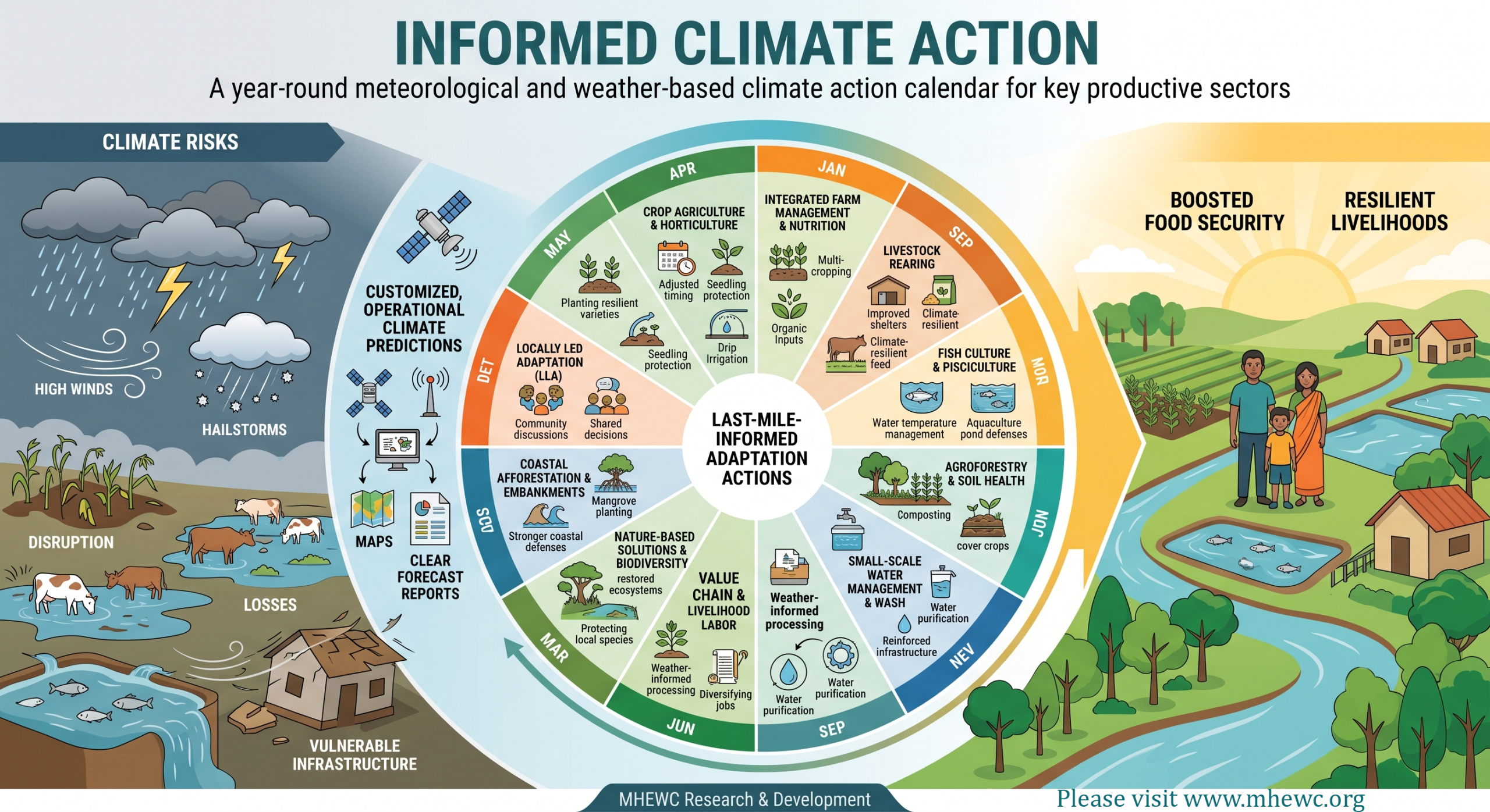
Climate change–induced weather and meteorological anomalies are creating severe disruption across productive livelihood sectors, including crop agriculture, livestock rearing, aquaculture, inland and marine fisheries, and agroforestry. Increasingly erratic weather patterns and the rapid onset of hazardous events such as damaging gusty winds, sudden thunderstorms, torrential rainfall, and hailstorms are causing significant losses to livelihood assets, including standing crops, seedlings, saplings, poorly built houses, and other vulnerable physical infrastructure and basic services.
At the same time, we are experiencing intermittent good weather and climate conditions for the productive sectors and elements. The favorable climate windows that occur intermittently within the season are still not being adequately predicted or projected by the local meteorological service. It means the productive sectors need customized, operational, and reliable climate predictions for frontline seasonal activities to boost food security and livelihoods.
In response, MHEWC aims to conduct research and development on last-mile-informed adaptation actions. This includes action research to develop a year-round meteorological and weather-based climate action calendar to guide adaptation interventions in key sectors. Priority areas may include informed and adaptive crop agriculture, horticulture(seedling/sapling), integrated Farm Management, Integrated nutrition management, WASH activties, Small scale water management, Value chain management, livelihood-sustaining labor activities, weather- and climate-informed livestock rearing, fish culture, pisciculture, agroforestry, soil health improvement actions, adaptive nature-based solutions, locally led adaptation (LLA) options, biodiversity conservation measures, coastal afforestation, and plantations along embankments.
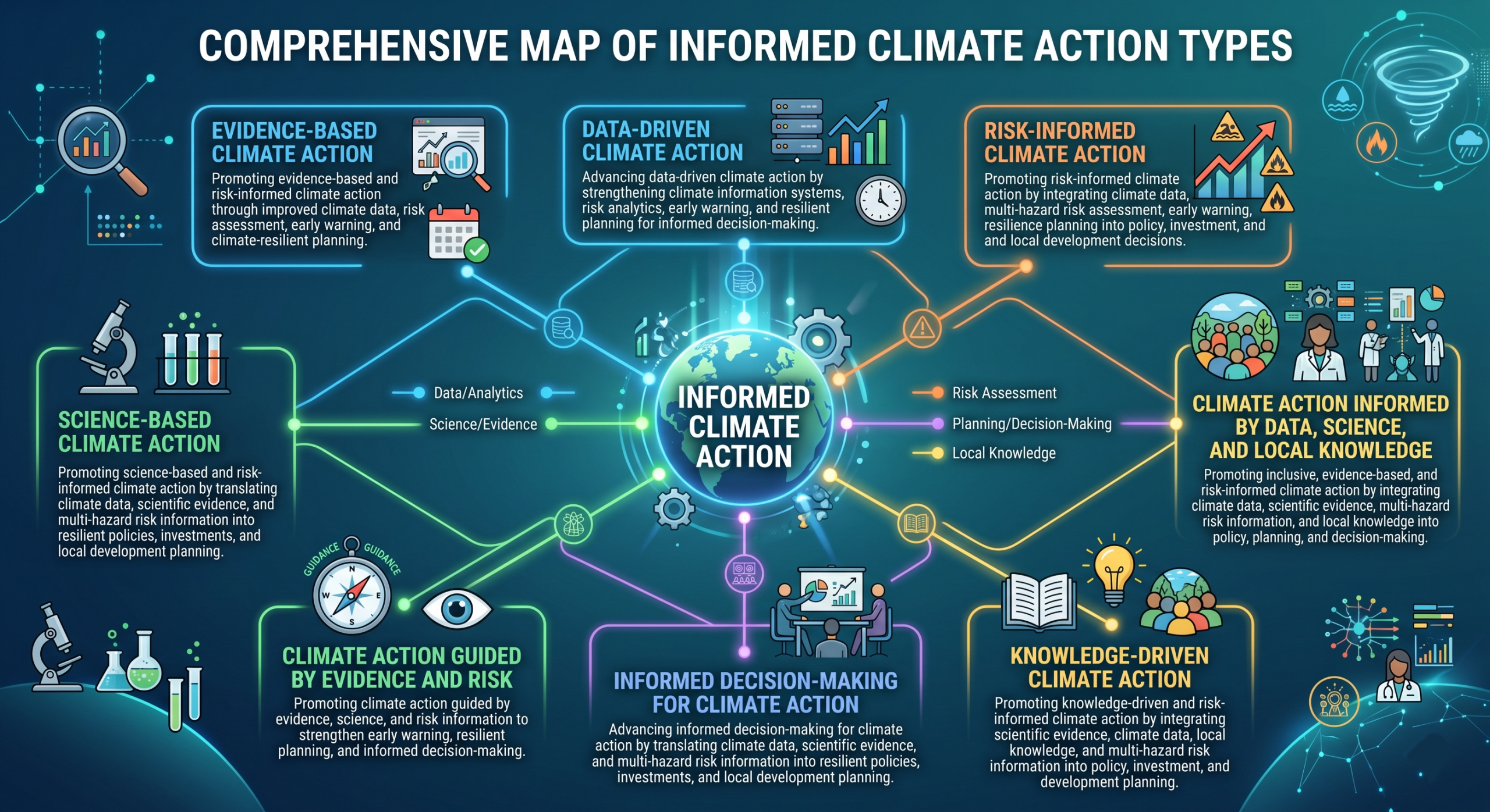
Types of Informed Climate Actions
- Evidence-Based Climate Action
Promoting evidence-based and risk-informed climate action through improved climate data, risk assessment, early warning, and climate-resilient planning.
- Data-Driven Climate Action
Advancing data-driven climate action by strengthening climate information systems, risk analytics, early warning, and resilient planning for informed decision-making.
- Risk-Informed Climate Action
Promoting risk-informed climate action by integrating climate data, multi-hazard risk assessment, early warning, and resilience planning into policy, investment, and local development decisions.
- Science-Based Climate Action
Promoting science-based and risk-informed climate action by translating climate data, scientific evidence, and multi-hazard risk information into resilient policies, investments, and local development planning.
- Climate Action Guided by Evidence and Risk
Promoting climate action guided by evidence, science, and risk information to strengthen early warning, resilient planning, and informed decision-making
- Informed Decision-Making for Climate Action
Advancing informed decision-making for climate action by translating climate data, scientific evidence, and multi-hazard risk information into resilient policies, investments, and local development planning.
- Knowledge-Driven Climate Action
Promoting knowledge-driven and risk-informed climate action by integrating scientific evidence, climate data, local knowledge, and multi-hazard risk information into policy, investment, and development planning.
- Climate Action Informed by Data, Science, and Local Knowledge
Promoting inclusive, evidence-based, and risk-informed climate action by integrating climate data, scientific evidence, multi-hazard risk information, and local knowledge into policy, planning, and decision-making.
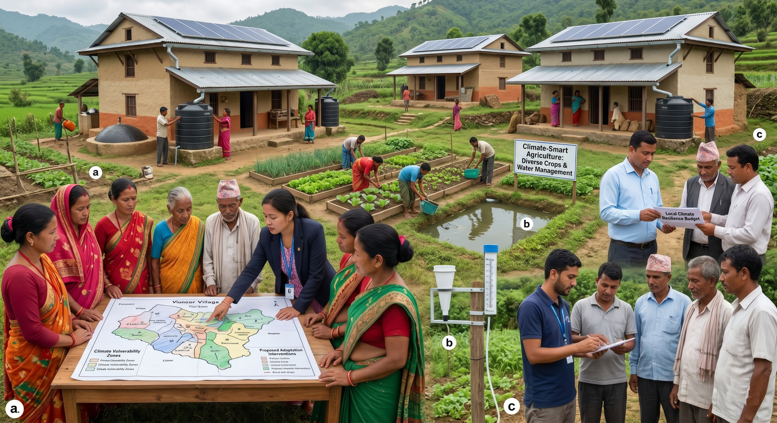
MHEWC supports informed climate action through the following areas:
a) Diagnosis of local climate systems and development of community-based adaptation interventions:
MHEWC supports the diagnosis of local climate regimes, the identification of adaptation indicators, and the planning of community-based adaptation schemes and projects. It also assists last-mile local actors and stakeholders in effectively implementing these initiatives.
b) Climate Early Warning & Good Climate/Weather Awareness System development to inform local elements, landscape, biodiversity, agroecology, agroclimatic, specific adaptation planning, scheme design, and implementation:
MHEWC supports the design and implementation of locally relevant adaptation actions and schemes grounded in local biodiversity, ecology, surface hydrology, agroecology, soil health, and the hydrological cycle. We specialize in community-level climate risk assessment, developing a good climate awareness system complementing local season ahead favorable for crop diversity/variety, impending ecologically friendly climate and weather pattern for the season, and development of climate-sensitive adaptive agriculture, aquaculture, livestock farming, integrated farm management techniques, and community-based adaptation scheme/project planning, design, and implementation.
c) Support local governments, last-mile actors, and stakeholders in climate resilience planning, budgeting, and scheme development:
MHEWC assists last-mile local governments in conducting sector-level climate risk assessments, planning resilient recovery and development, and establishing local climate change adaptation, mitigation, resilience planning, and budgeting systems.
d) Climate-Resilient Model Household and Community Development :
MHEWC supports last-mile local actors, communities, and households in designing and developing inclusive, natural resource-based model households. These resilience models are intended to help households absorb and withstand climate shocks. The design approach emphasizes the use of locally available renewable resources and appropriate renewable energy technologies, including solar PV, biogas digesters, water harvesting systems for irrigation and drinking water, small-scale water resource management, micro-hydro schemes, and wind power systems.
MHEWC empowers grassroots actors and rural households to design and implement inclusive, climate-adaptive model homes that can withstand environmental shocks. These resilient households utilize locally available renewable resources and green technologies, including solar power, biogas, improved cookstoves, rainwater harvesting, wind, and micro-hydro systems, to meet daily cooking and lighting needs. Ultimately, this sustainable approach comprehensively strengthens a community’s water, sanitation (WASH), food, livelihood, and green energy security.
Delivering “good climate” alerts to the frontline workers and farmers
Delivering “good climate” alerts is a critical, yet often overlooked, task for local weather and meteorological services and national meteorological & hydrological services organizations (NMHS), which is a critical gap in modern climate adaptation strategies. Most meteorological services and agricultural policies are heavily skewed toward disaster risk reduction, focusing almost entirely on early warning systems for rapid-onset hazards such as sudden thunderstorms, hail, and torrential rain. However, as it rightly points out, resilience isn’t just about surviving the bad days; it is about maximizing the good ones. Failing to project and utilize intermittent favorable climate windows leaves immense productive potential unutilized, directly threatening food security and the economic stability of frontline sectors.
The Value of Predicting “Favorable weather & climate Windows”
When erratic weather is the norm, a sudden three-to-five-day window of optimal temperature, stable winds, and clear skies becomes a highly valuable asset. Knowing exactly when these micro-seasons will occur allows for decisive, high-yield actions:
Crop Agriculture: Farmers can time the application of fertilizers and pest management so they aren’t immediately washed away by unexpected rain. They can also strategically harvest vulnerable crops, such as timing the Boro rice harvest in low-lying areas just before sudden flash floods or hailstorms hit.
Fisheries and Aquaculture: Inland and marine fishers can confidently navigate waters to maximize their catch yields without risking their lives, boats, or nets to sudden squalls.
Agroforestry & Livestock: Producers can safely transport vulnerable seedlings, schedule sapling planting during optimal soil moisture windows, and manage livestock foraging safely.
Moving Toward Customized Operational Services
To bridge this gap, local meteorological services must transition from generic weather reporting to providing localized, actionable agrometeorological forecasting. This requires:
Hyper-Local Data Grids: Moving beyond broad regional averages to micro-climate forecasting, utilizing localized weather stations integrated directly into specific agro-ecological zones.
Sector-Specific Advisories: Translating standard meteorological data into operational, sector-specific directives (e.g., translating “low humidity and moderate winds” into “an optimal 48-hour window for grain drying and marine transit”).
Proactive Opportunity Capture: Shifting the narrative from purely defensive (evacuation and securing assets) to offensive (maximizing planting, harvesting, and fishing activities during guaranteed safe windows).
To help visualize how capitalizing on these positive predictive windows can drastically change livelihood outcomes compared to traditional risk-avoidance, I have generated an interactive simulator below.

Applicability of Good Weather and Climate Alerts
Good Weather and Climate Alerts should be designed as short-range, operational, and sector-specific forecasts that identify favorable climate windows for frontline livelihood, adaptation, and resilience-building actions. These alerts should support vulnerable sectors and their key operational elements, including crop agriculture, conservation agriculture, subsistence farming, livestock management, fisheries, aquaculture, pisciculture, water management and retention, water harvesting, WASH services, drinking water supply, soil health improvement, afforestation and tree plantation, integrated farm management, integrated pest management, integrated nutrition management, coastal protection, small-scale water management, flood control, biodiversity management, and other locally driven adaptation actions.
Rather than limiting weather services to passive meteorological broadcasting, the system should translate short-, medium-, and long-range forecasts into practical, impact-oriented, and action-based advisories. These advisories should inform farmers, frontline workers, local institutions, and sector actors about what actions can be safely and productively undertaken during favorable weather and climate conditions. This includes guidance on planting, irrigation, harvesting, livestock care, fish culture, pest management, water storage, embankment maintenance, tree plantation, soil improvement, and other climate-sensitive livelihood activities.
Customized operational forecasts should therefore be developed for each frontline sector and activity. These forecasts should identify not only potential hazards but also favorable climate opportunities that can be used to improve productivity, reduce exposure, strengthen preparedness, and minimize loss and damage. When frontline workers and farmers receive timely, understandable, and location-specific weather and climate information, they can take early actions that protect livelihoods, improve food security, and reduce climate-related risks.
To make these customized operational predictions truly effective, appropriate communication channels must be designed and deployed for delivering Good Weather and Climate Alerts to frontline workers, farmers, fishers, livestock keepers, local service providers, and community institutions. Since these favorable climate windows are highly operational and time-sensitive, the dissemination mechanism must be deeply embedded in local communities and aligned with their daily livelihood activities.
The dissemination structure may include the following elements:
- Sector-specific advisory bulletins
Develop simple and actionable advisories for agriculture, livestock, fisheries, water management, WASH, coastal protection, forestry, and local adaptation actions. Each bulletin should clearly explain what favorable weather condition is expected, where it is expected, when it will occur, and what actions should be taken. - Localized last-mile communication channels
Deliver alerts through SMS, voice messages, mobile applications, community radio, WhatsApp groups, local notice boards, extension workers, farmer field schools, cooperatives, community volunteers, and local government networks. - Frontline worker–led dissemination
Engage agricultural extension officers, livestock officers, fisheries officers, health workers, WASH facilitators, disaster management volunteers, community-based organizations, and local government representatives as trusted intermediaries for translating forecasts into practical action. - Impact-based and action-oriented messaging
Shift communication from technical weather language to impact-based messages. Instead of only stating expected rainfall, temperature, wind speed, or humidity, alerts should explain the likely opportunity or risk and recommend specific actions for each sector. - Forecast-based anticipatory action
Link Good Weather and Climate Alerts with forecast-based anticipatory actions. This means using favorable climate windows to trigger early livelihood actions, such as seedbed preparation, crop protection, water storage, fish pond preparation, livestock vaccination, fodder preservation, embankment repair, drainage cleaning, and tree plantation. - Community feedback and verification
Establish feedback mechanisms so that farmers, fishers, livestock keepers, women’s groups, local leaders, and frontline workers can report whether the alerts were useful, accurate, timely, and actionable. This feedback should be used to improve future forecast customization and communication. - Integration with local planning and service delivery
Good Weather and Climate Alerts should be embedded into local development planning, agricultural calendars, disaster preparedness plans, climate adaptation actions, food security interventions, and sectoral service delivery systems. Through this approach, Good Weather and Climate Alerts can become a practical decision-support tool for frontline communities. They can help transform weather and climate information into timely, localized, and productive actions that reduce loss and damage, enhance livelihood resilience, and strengthen climate-adaptive development at the local level. - Integration into Existing MHEWS and EWEA Protocols “Good climate” notifications should not require an entirely new communication infrastructure. Instead, they should be integrated into existing Multi-Hazard Early Warning Systems (MHEWS). The same architecture used to deploy Early Warning for Early Action (EWEA) protocols for impending cyclones or floods can be utilized to push “Favorable Window” alerts. If the system is trusted to save lives during a crisis, it will be trusted to secure yields during optimal conditions.
- Cascading to the Grassroots Level: The National-level broadcasts rarely trigger local action. The alerts must cascade through local governance and agricultural structures directly to the field. Translating meteorological data into sector-specific advisories at the district level and then pushing those advisories down to the sub-district, union, and commune levels ensures the information is contextually relevant. Agricultural extension officers and local committee members at the Union level can then contextualize the alert for specific communities (e.g., advising a specific village to begin harvesting based on local topography).
- Utilizing Multi-Channel ICT Delivery: Depending on the digital literacy and infrastructure of the specific community, a mix of high-tech and low-tech channels ensures maximum penetration:
- Targeted SMS and Voice (IVR): Sending location-specific voice messages in the local dialect directly to farmers’ and fishers’ mobile phones. The message must focus on the action rather than the weather (e.g., “A 4-day dry window begins tomorrow. This is the optimal time to complete harvesting and begin grain drying.”).
- Digital Display Boards: Installing low-cost, solar-powered digital displays at community hubs, local markets, or Union centers that show color-coded windows for safe fishing or planting.
- Community Radio: Still one of the most effective tools for reaching remote agricultural and coastal communities with hyper-local agrometeorological advice.
11. Establishing Feedback Loops : Delivering the alert is only the first step; validating its impact is critical for refining future predictions. Extension workers can utilize digital data collection methodologies to report back on the utilization of these climate windows. By deploying mobile forms via platforms like KoboToolbox or using Computer-Assisted Personal Interviewing (CAPI) techniques during routine field visits, you can quickly gather data on how many households successfully adjusted their activities based on the alert and calculate the resulting impact on their livelihood yield. By defining the exact operational windows for these productive sectors and leveraging established local networks to deliver them, we can turn erratic weather from a constant threat into an intermittently exploitable asset. This is the critical operational pivot. Without this feedback loop, a “good climate” forecasting system remains a one-way megaphone. You never actually know if the alert translates into a protected livelihood. To operationalize this using digital data collection methodologies like CAPI and KoboToolbox, the process must be lightweight for the extension workers and highly structured to feed directly back into the early warning design.
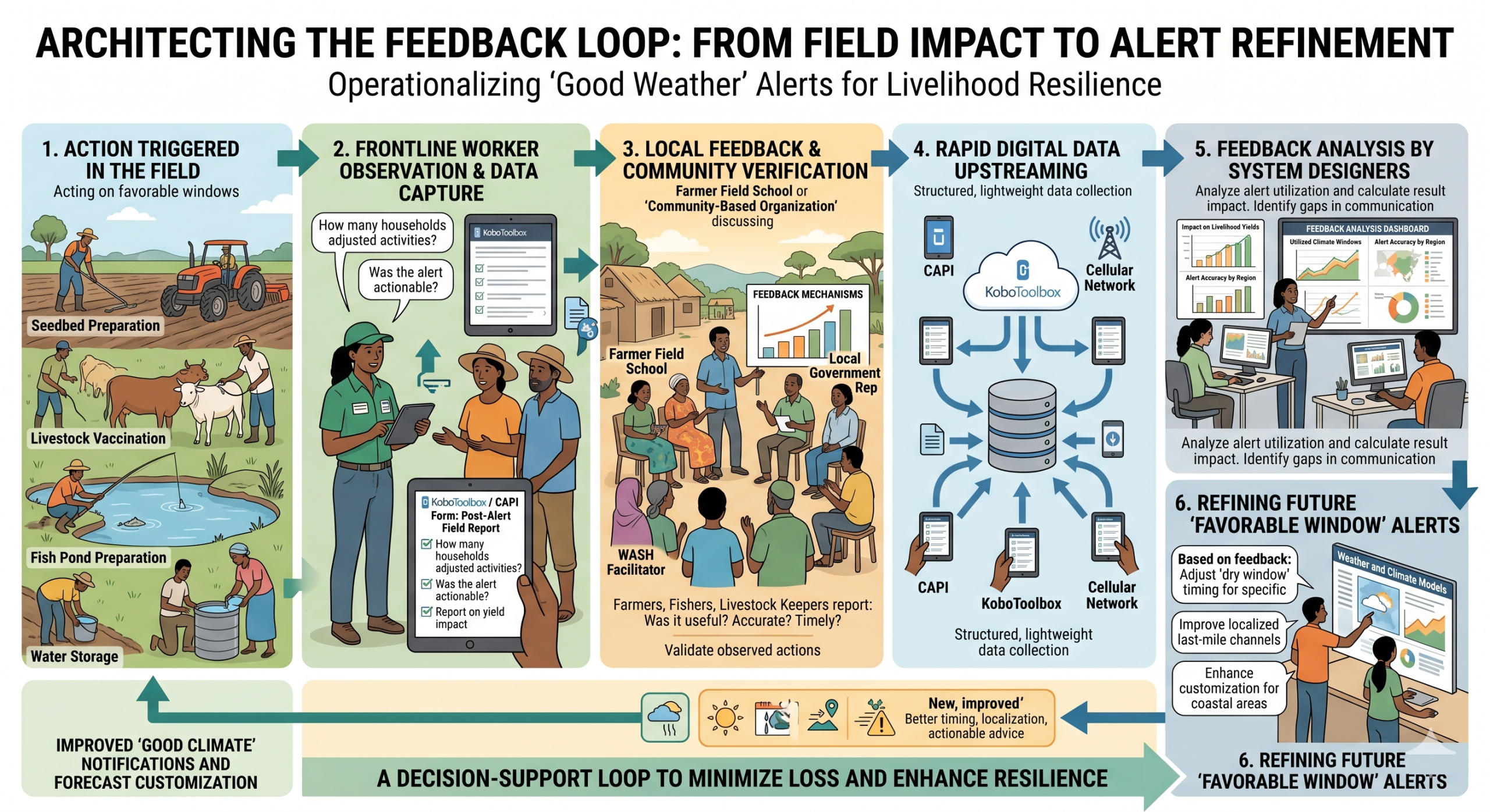
Here is how to architect that feedback loop from the field back to the system designers.
a) Structuring the CAPI/KoboToolbox Instrument
The field survey must be rapid (under 5 minutes) to ensure high completion rates during routine extension visits. It should capture the entire lifecycle of the alert: reception, comprehension, action, and outcome.
Data Category | Question Type (Kobo) | Purpose |
Location Tracking | geopoint | Captures GPS coordinates for spatial analysis. |
Alert Reception | select_one (Yes/No) | Did the household receive the “Favorable Window” alert? |
Comprehension | select_one | Could they accurately repeat the required action? |
Action Taken | select_multiple | Which actions did they take? (e.g., Sowing, Harvesting). |
Barrier to Action | select_one | If no action was taken, why? (e.g., Lack of labor, late notice). |
Yield Estimation | integer / decimal | Estimated loss avoided or yield gained (e.g., kg of crop saved). |
When deploying this across local governance tiers—from district down to the Upazila and Union levels—order and timing are critical.
c) Deploy Post-Window CAPI Instruments:
Immediately after a favorable climate window closes, dispatch the KoboToolbox forms to the mobile devices of agricultural extension workers and Union-level volunteers.
d) Conduct Targeted Field Sampling:
Extension workers conduct rapid interviews with a randomized sample of farmers and fishers across targeted agro-ecological zones, capturing responses and geolocation data entirely offline.
e) Export and Spatial Overlay:
Once devices sync, export the dataset from KoboToolbox as a CSV for statistical analysis and as a GeoJSON file. Overlay this GeoJSON data onto existing GIS maps of the region.
f) Analyze Delivery vs. Action Gaps:
Identify spatial bottlenecks. If an entire Union received the alert but took no action, analyze the “Barrier to Action” data to determine if the issue was the alert’s timing, terminology, or external resource deficits.
g) Refine MHEWS Protocols:
Feed these insights directly back into the system design. Adjust the lead-time of the alerts, rewrite the advisories using better local terminology, and re-calibrate the next broadcast
h) Calculating the Livelihood Impact
To justify the continued investment in “good climate” predictions, you must quantify the economic benefit. The feedback loop provides the baseline for this calculation. By comparing the yield outcomes of households that received and acted on the alert (the test group) against those who did not (the control group), you can calculate the Loss Avoided.
Aggregating this data over a season allows system designers to prove that proactive opportunity capture directly reduces the economic risk metrics such as Probable Maximum Loss (PML) typically associated with erratic weather events.
Good climate Prediction :
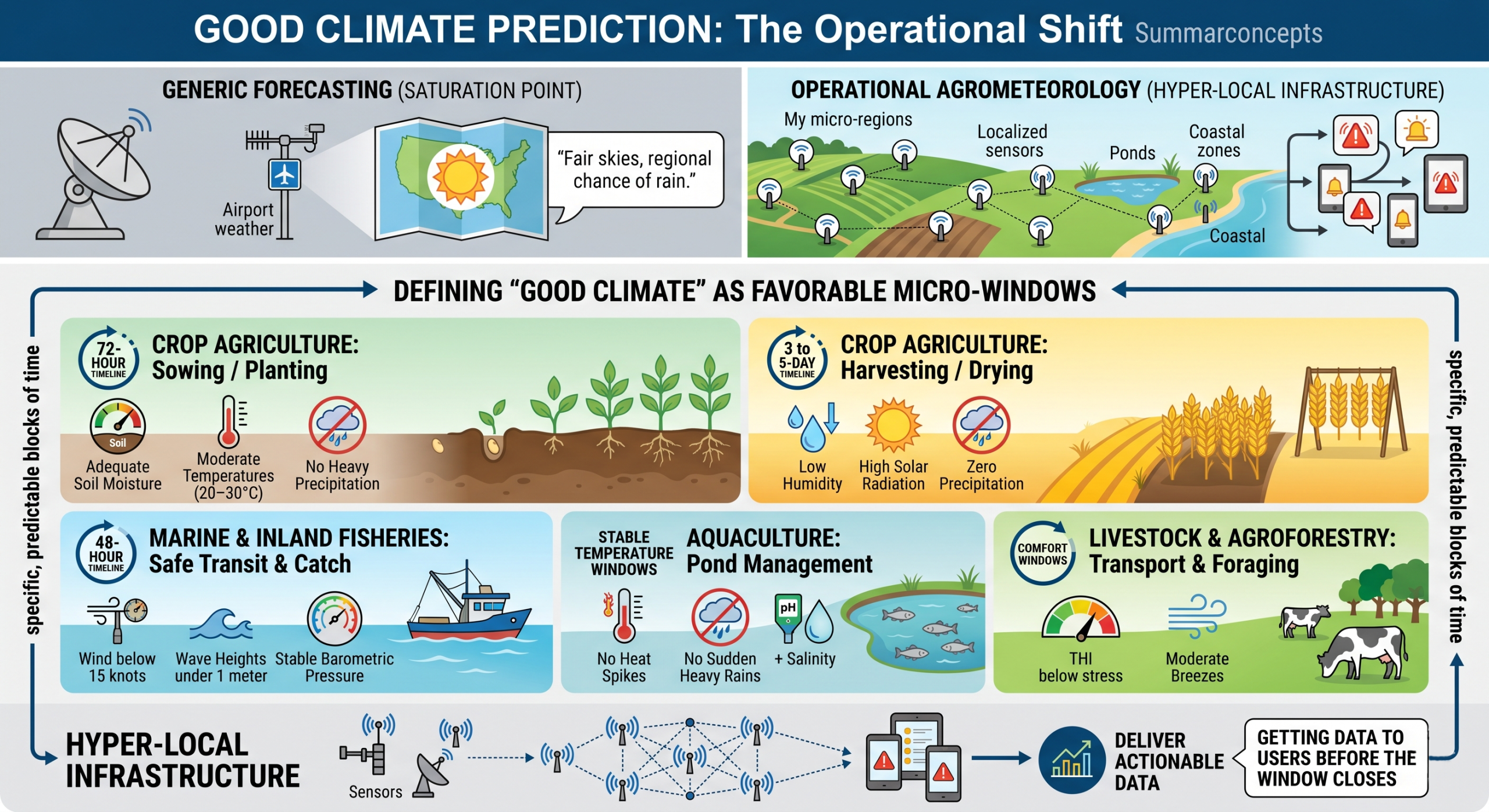
In the context of erratic weather and climate adaptation, “good climate” is not a universally fixed state like a “sunny day.” It is highly operational and relevant. A perfect day for a fisherman might be disastrous for a farmer needing to dry crops. Instead of general forecasts, we need to define “good climate” as favorable micro-windows specific, predictable blocks of time where atmospheric conditions perfectly align with a biological or operational need. To build localized, actionable forecasting, meteorological services must break down what “good” actually means for each sector.
Sector-Specific “Good Climate” Windows
| Sector | Activity | Operational “Good Climate” Definition |
| Crop Agriculture | Sowing / Planting | 72-hour window of adequate soil moisture, moderate temperatures (e.g., 20–30°C), and no heavy precipitation forecasted, allowing seeds to establish without washing away. |
| Crop Agriculture | Harvesting / Drying | 3 to 5-day window of low humidity, high solar radiation, and zero precipitation to prevent post-harvest rot and maximize grain drying. |
| Marine & Inland Fisheries | Safe Transit & Catch | 48-hour window of wind speeds below 15 knots, wave heights under 1 meter, and stable barometric pressure (indicating no sudden squalls or thunderstorms). |
| Aquaculture | Pond Management | Stable temperature windows without extreme heat spikes (which deplete oxygen levels in ponds) or sudden heavy rains (which alter water pH and salinity rapidly). |
| Livestock & Agroforestry | Transport & Foraging | Periods where the Temperature-Humidity Index (THI) remains below heat-stress thresholds, combined with moderate breezes. |
To capture these windows, we have to move beyond regional satellite data and rely on hyper-local infrastructure.
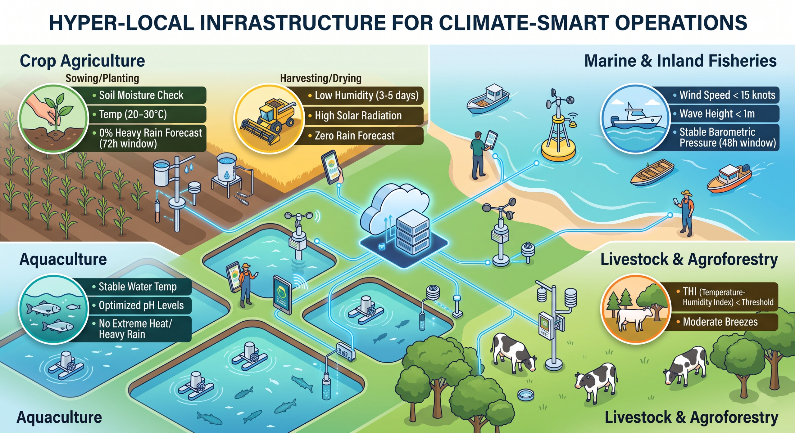
The shift from generic forecasting to operational agrometeorology requires sensors placed directly in the fields, ponds, and coastal zones. A weather station 50 kilometers away at an airport cannot accurately predict a 48-hour moisture window for a specific valley’s rice harvest.
If we can accurately define and predict these specific parameters, the next challenge is getting that data into the hands of those who need it before the window closes.
How can we translate these hyper-local ‘good climate’ metrics into easily understandable and actionable advisories for frontline workers, crop-farmers, livestockers, and fishers?
Translating raw meteorological data into actionable advisories requires a shift from scientific reporting to behavioral communication. The goal is to ensure that a farmer or fisher immediately understands not just what the weather is doing, but exactly what they need to do in response.
Here are the most effective methodologies for translating these metrics into high-impact advisories:
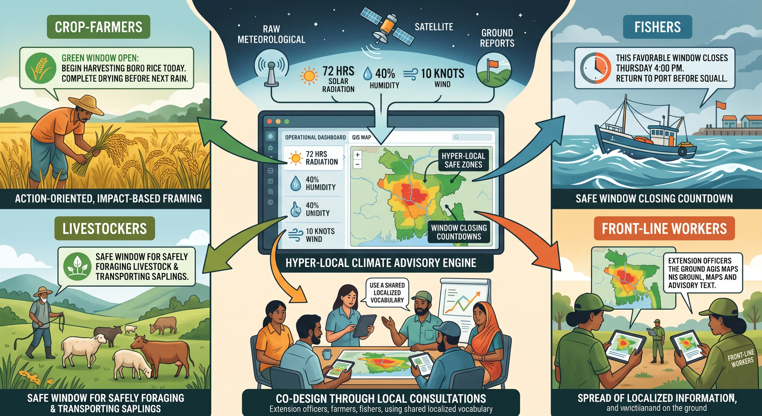
1. Co-Design Through Local Consultations
The advisories to be co-designed with the end-users. Running local consultations at the District, Sub-District, Commune, and village levels to gather frontline feedback is a highly effective way to build a localized vocabulary. By holding validation workshops to synthesize these grassroots recommendations, the resulting advisories will use the exact phrases, idioms, and agricultural benchmarks that the community already trusts and understands.
2. Visual Translation via Geospatial Tools
Numbers like “40% humidity” or “10 knots of wind” are abstract. Translating these metrics into visual formats removes the guesswork. Utilizing GIS and remote sensing tools allows for the creation of hyper-local, color-coded maps. Instead of sending raw data, agricultural extension officers receive a spatial dashboard indicating exact safe zones—for example, mapping out which specific villages are currently in a “green zone” for applying fertilizer without runoff risk, or which coastal inlets are safe for navigation.
3. Action-Oriented, Impact-Based Framing
Advisories must follow the core principles of Early Warning for Early Action (EWEA) by focusing on the necessary action rather than the atmospheric condition.
Poor Translation: “Forecast: 72 hours of uninterrupted solar radiation, 25°C, 30% humidity.”
Actionable Translation: “Green Window Open: You have 3 days of safe, dry weather. Begin harvesting Boro rice today to ensure complete drying before the next rain cycle.”
4. Holistic Integration Across Productive Sectors
A single weather anomaly impacts multiple elements of a household’s livelihood. Translating metrics through the lens of Integrated Farm Management ensures the advice is comprehensive. A single “Good Climate” advisory could provide layered guidance: “Safe weather window for the next 48 hours: Optimal time to transport saplings, safely forage livestock, and maintain aquaculture pond levels without sudden rain disruption.”
5. Clear “Window Closing” Countdowns
One of the most effective ways to drive action is to clearly communicate the duration and the end of the favorable window. Formulating the advisory as a countdown creates a sense of safe urgency. Advisories should explicitly state: “This favorable window will close on Thursday evening. Complete all deep-water fishing and return to port by 4:00 PM Thursday before squall conditions return.” By grounding the language in validated local terminology, utilizing geospatial visualizations, and keeping the focus strictly on sector-specific actions, the data is transformed from a simple forecast into an operational tool for maximizing livelihood yields.
To make meteorological data truly actionable for a farmer, the alert needs to directly answer the question: “What should the farmer/livestocker/fisher do on the farm today?”
Raw data causes decision paralysis. To drive action, the translation process must convert atmospheric conditions into clear, localized agricultural directives. Here is a framework for structuring that translation:
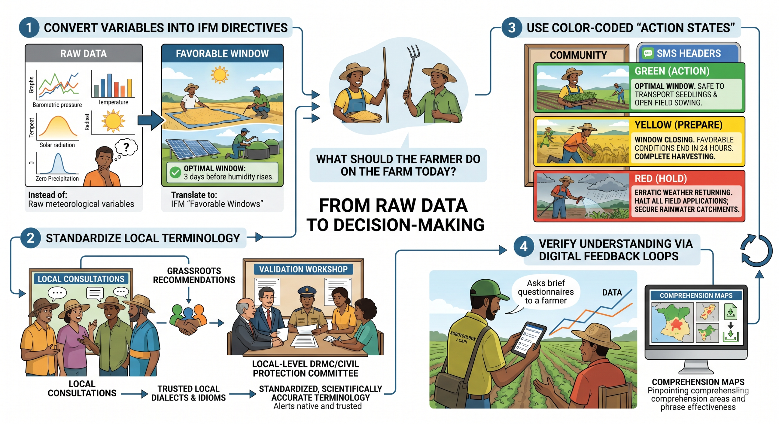
- Convert Variables into IFM Directives
Farmers do not need to know the barometric pressure; they need to know if it is safe to apply inputs or harvest. The meteorological service must map these “favorable windows” directly to the seasonal agricultural calendar and Integrated Farm Management (IFM) practices.
- Instead of: “Forecast indicates 72 hours of 28°C temperatures, moderate solar radiation, and zero precipitation.”
- Translate to: “Favorable Window: Optimal conditions for drying harvested grain and performing maintenance on solar PV and biogas digesters. Farmers have 3 days before humidity rises.”
- Standardize Local Terminology
An alert fails if the vocabulary does not resonate with the local farming community. Conducting localized consultations at the local level ensures that the messaging uses trusted local dialects and farming idioms. Bringing those grassroots recommendations together for a centralized validation process, such as a workshop at the local-level Disaster Risk Management Committee (DRMC)/Civil Protection Committee (CPC), allows individuals to create standardized, scientifically accurate terminology that still feels entirely native to the frontline farmer.
- Use Color-Coded “Action States”
Instead of dense text, translate the data into simple, universally understood visual cues for community display boards or brief, actionable headers for SMS.
- Green (Action): “Optimal Window. Safe to transport seedlings and begin open-field sowing.”
- Yellow (Prepare): “Window Closing. Favorable conditions end in 24 hours. Complete harvesting.”
- Red (Hold): “Erratic Weather Returning. Halt all field applications; secure rainwater harvesting catchments.”
- Verify Understanding via Digital Feedback Loops
The individual must actively measure whether the translated alert was understood and acted upon. Agricultural extension workers can use digital data collection tools to ground-truth the alerts during routine field visits. Deploying brief, structured questionnaires via KoboToolbox or utilizing Computer-Assisted Personal Interviewing (CAPI) allows field staff to rapidly assess farmer comprehension. By collecting this data and exporting the results as CSV or GeoJSON files to map comprehension geographically can pinpoint exactly which phrases or alert formats are working and which need to be refined for the next favorable climate window.
We intend to undertake extensive research and development on this issue. We would therefore welcome your partnership and financial support to help advance the required Research and Development efforts and strengthen evidence-based solutions in this area. Please contact: zmsajjad@gmail.com , WhatsApp : + 88 01711 979179
Please visit community-based climate change adaptation actions at https://www.facebook.com/localclimate.adaptiveliving