Warning: Array to string conversion in /home/mhewcorg/public_html/wp-includes/class-wp-embed.php on line 469
Climate risk and vulnerabilities of Armenia
Armenia is highly vulnerable to climate change and multi-hazard risks due to its mountainous terrain, active seismic setting, landlocked geography, water-resource constraints, dependence on climate-sensitive agriculture, exposure to floods and landslides, and increasing risks from drought, heat stress, hail, mudflows, forest degradation, and rural livelihood vulnerability. Armenia’s population and economy are exposed to both earthquakes and floods, with earthquakes posing the higher-impact but lower-probability risk. (PreventionWeb)
Armenia is highly exposed and vulnerable to climate change and multi-hazard risks due to its mountainous terrain, active seismic setting, water-resource constraints, climate-sensitive agriculture, fragile slopes, rural livelihood dependence, and aging infrastructure. The country faces major risks from earthquakes, droughts, floods, flash floods, landslides, mudflows, hailstorms, heat stress, water scarcity, forest degradation, agricultural losses, and climate-sensitive health impacts. Climate change is expected to intensify these vulnerabilities through rising temperatures, more severe droughts, extreme precipitation events, increased flood and landslide risk, water stress, reduced agricultural productivity, and growing pressure on infrastructure, health, ecosystems, energy, tourism, and vulnerable communities. Strengthening multi-hazard early warning systems, impact-based forecasting, earthquake-safe infrastructure, flood and landslide risk reduction, integrated drought management, water security, climate-resilient agriculture, forest and watershed restoration, disaster risk financing, and locally led adaptation is essential to reduce losses and protect Armenia’s development gains.
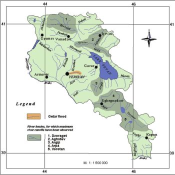
The hydrological network of the Republic of Armenia
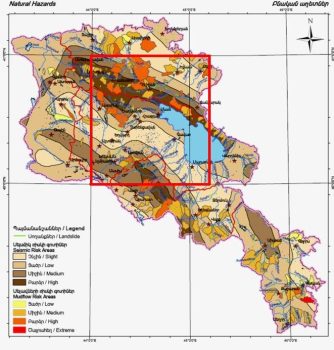
Map of national hazards of Armenia, Caucus and study aria shown by red rectangle
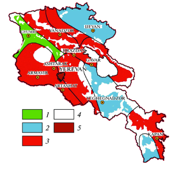
Map of maximum seismic risk of residential buildings for the territory of Armenia
1. Multi-hazard exposure
Armenia’s main hazards include earthquakes, floods, droughts, hailstorms, landslides, mudflows, heatwaves, wildfires, soil erosion, and water scarcity. GFDRR reports that Armenia lost well over US$1.5 billion between 1994 and 2014 from natural hazards such as floods, earthquakes, and droughts, showing that disaster risk is already a major development concern. (GFDRR)
Earthquake risk remains one of Armenia’s most severe disaster risks, while floods, droughts, hailstorms, and landslides create frequent and localized losses. The World Bank notes that floods in 2010 caused an estimated US$10 million in damage and that Armenia also faces droughts, hailstorms, and landslides beyond seismic hazards. (World Bank)
2. Climate change as a risk multiplier
Climate change is increasing Armenia’s exposure to drought, heat stress, floods, hail, and landslides. The World Bank’s Armenia Country Climate and Development Report states that Armenia is highly vulnerable to climate impacts, particularly floods, droughts, heat stress, hail, and landslides. It also estimates that climate impacts on the water and agriculture sectors alone could reduce the economy by up to 3% by 2060 and increase poverty by up to 2.7 percentage points by 2030. (World Bank)
The most serious climate-change impacts expected in Armenia include more severe drought and more extreme precipitation events, which can lead to increased mudslides and landslides. (IMF eLibrary)
3. Flood, landslide, and mudflow vulnerability
Floods and landslides are major risks in Armenia’s mountainous and valley landscapes. Heavy rainfall, rapid snowmelt, steep slopes, degraded catchments, deforestation, road cutting, poor drainage, and settlement expansion in exposed areas can trigger flash floods, mudflows, landslides, erosion, road damage, bridge failure, and damage to houses, schools, health facilities, water systems, and agricultural land.
The World Bank climate profile highlights that increased flood and landslide hazards require strong disaster risk reduction attention, especially for poorer rural communities. (Climate Change Knowledge Portal)
4. Drought, water scarcity, and agricultural vulnerability
Drought is one of Armenia’s most important climate risks. Agriculture, irrigation, rural livelihoods, hydropower, drinking-water supply, and ecosystems depend on reliable precipitation, snowmelt, groundwater, reservoirs, and river flows. Increasing temperatures and reduced precipitation in agricultural valleys are expected to increase aridity and threaten sector viability. (IMF)
Armenia is also developing an Integrated Drought Management Plan, building on the country’s National Adaptation Plan process and adaptation priorities across forest ecosystems, human health, water resources, agriculture, energy, human settlements and infrastructure, and tourism. (GWPO-GWP)
5. Earthquake and infrastructure vulnerability
Armenia’s seismic risk is a central feature of its multi-hazard profile. GFDRR’s disaster risk profile identifies earthquakes as posing the greater risk of a high-impact event compared with floods, even though such events are lower probability. (PreventionWeb)
Earthquake vulnerability is especially important for urban settlements, schools, hospitals, housing, transport corridors, water systems, energy infrastructure, and public buildings. In mountainous areas, earthquakes can also trigger landslides, rockfalls, road blockages, and cascading impacts on emergency access and recovery.
6. Sector-specific vulnerability summary
| Sector | Main climate and multi-hazard risks |
|---|---|
| Agriculture and food security | Drought, heat stress, hail, frost, floods, irrigation stress, crop losses, soil erosion |
| Water resources | Reduced precipitation, snowmelt variability, drought, groundwater stress, flood contamination |
| Settlements and infrastructure | Earthquakes, floods, landslides, mudflows, drainage failure, aging infrastructure |
| Transport | Landslides, mudflows, rockfalls, flood damage, bridge and road disruption |
| Health | Heat stress, air pollution, waterborne disease after floods, disaster-related service disruption |
| Forests and ecosystems | Drought stress, wildfire risk, forest degradation, biodiversity loss, erosion |
| Energy | Hydropower variability, heat-related demand, infrastructure exposure to floods and seismic hazards |
| Tourism | Landslides, heat stress, water scarcity, wildfire risk, mountain-road disruption |
7. Social vulnerability
The most vulnerable groups include smallholder farmers, rural households, low-income communities, elderly people, children, people with disabilities, women-headed households, communities in flood- and landslide-prone valleys, households dependent on rainfed agriculture, and people living in earthquake-prone or poorly constructed buildings.
Vulnerability is highest where hazard exposure overlaps with poverty, limited access to insurance, weak housing, aging infrastructure, low savings, limited irrigation access, and restricted access to timely early warning and recovery support.
8. Priority resilience needs
Armenia’s resilience agenda should prioritize multi-hazard early warning systems, impact-based forecasting, earthquake risk reduction, flood and landslide forecasting, drought monitoring, hail-risk management, climate-resilient agriculture, integrated water-resource management, forest and watershed restoration, resilient infrastructure, disaster risk financing, and locally led adaptation.
| Priority area | Key actions |
|---|---|
| Early warning and anticipatory action | Impact-based warnings for floods, droughts, heat, hail, landslides, mudflows, wildfires, and earthquakes |
| Flood and landslide risk reduction | Hazard mapping, slope stabilization, drainage improvement, riverbank protection, road-risk screening |
| Earthquake resilience | Seismic-safe construction, retrofitting schools and hospitals, emergency drills, resilient lifeline infrastructure |
| Drought and water security | Integrated drought management, reservoir planning, groundwater monitoring, irrigation efficiency, water-saving technologies |
| Climate-resilient agriculture | Drought- and heat-tolerant crops, hail protection, agro-climate advisories, crop insurance, soil conservation |
| Forest and ecosystem resilience | Reforestation, wildfire preparedness, watershed restoration, erosion control, biodiversity protection |
| Urban and infrastructure resilience | Risk-informed land-use planning, resilient roads and bridges, climate-proofed water and energy systems |
| Risk financing | Contingency finance, insurance mechanisms, forecast-based financing, resilient recovery planning |
Ministry of Internal Affairs of the RA Rescue Service https://rescue.mia.gov.am/
In 1988, the earthquake of Spitak revealed many issues related to civil protection (CP) system in Armenia and became the main impetus of radical reorganization of that system and creating of Emergency Management Administration of Government of Armenia.
In 1991 the Emergency Management Administration was set up, and Stepan Badalyan was appointed the Head of EMA. The CP headquarter with its all units, which was acting in Armenia from 1961, in the end of 1991 has been put under the Emergency Management Administration. The Administration, in contrast to the narrow frame of the civil protection activities in the past, accepted a new, wide approach to the organization of the whole system from a conceptual, professional, and legal point of view, based on the possible occurrence of large-scale disasters and accidents, their classification, and risk assessment.
Projections suggest Armenia could experience warming at levels significantly above the global average, with potential warming of 4.7°C by the 2090s, above the 1986–2005 baseline, under the highest emissions pathway (RCP8)
DISASTER RISK MANAGEMENT IN ARMENIA
The main aim of Disaster Management (DM) direction is to reduce the vulnerability and increase the resilience of the population towards natural and man-made disasters through disaster risk reduction on a community level and strengthen Disaster Preparedness and Response structure of the Armenian Red Cross Society (ARCS).
Located on the Alps-Himalaya seismic zone, Armenia has historically been prone to earthquakes. The last devastating earthquake in 1988 rocked Spitak, killing 25,000 people and injuring 19,000, severely damaging 517,000 homes and causing an estimated economic loss of US$ 15-20 billion in Northern parts of the country. Floods in the country also pose serious danger. For instance, flooding in 2010 caused an estimated US$ 10 million in damage. However, this list of natural disasters is not complete; Armenia also faces other hazards such as droughts, hail storms and landslides. The Government of Armenia has recognized the importance of disaster risk management, highlighting that natural hazards threaten the country’s development. In this regard, the World Bank Group is offering support to further advance disaster resilience in the country by launching the Armenia National Disaster Risk Management Program. PROGRAM OVERVIEW: Funding: US$1.75 million Duration: 2.5 years, starting from 2015 Key counterparts: Ministry of Territorial Administration and Emergency Situations, Ministry of Urban Development, Ministry of Education and Science, Ministry of Finance, other relevant government agencies, Yerevan Municipality and other relevant Marz and communities in Armenia. The National Disaster Risk Management Program is aimed at supporting the Government of Armenia to further advance disaster resilience by: (1) improving disaster risk information; (2) enhancing disaster risk reduction; (3) strengthening disaster preparedness; and (4) improving understanding of fiscal disaster risks and risk financing options.
Array
Subject: Looking forward to the scope of work and partnership opportunity with the Ministry of Emergency Situations – Armenia
To,
The Director of Rescue Service(RS) – Deputy Minister of IA, Armenia
Dear Sir,
Greetings from the Multi-Hazard Early Warning System Design and Implementation Center (MHEWC).
MHEWC provides technical solutions to strengthen Disaster Risk Management (DRM) governance systems, climate and multi-hazard risk management, and end-to-end early warning system design and implementation. We would be pleased to offer technical support to the Rescue Service(RS) – National Committee for Disaster Management, Armenia in the following areas:
a) Upgrading RS’s existing web portal into a geospatial, database-driven, and app-enabled Decision Support System (DSS) to support real-time disaster risk governance, planning, preparedness, response, and recovery management.
b) Conducting climate and multi-hazard risk and vulnerability assessments, including the preparation of geospatial hazard, exposure, vulnerability, and risk maps, and the establishment of a centralized risk information repository and database management system.
c) Assessing existing monitoring, observation, and early warning capacities and supporting RS in the installation, enhancement, and integration of observation networks, including Automated Weather Stations (AWS), hybrid weather and hazard monitoring systems, and sensor-ingested real-time data systems linked to a functional DSS.
d) Designing and operationalizing end-to-end multi-hazard early warning systems, including weather and hazard nowcasting services, impact-based forecasting, forecast-based anticipatory early action, forecast-based emergency preparedness and response management, forecast-based financing, Early Action Protocol development, and DSS-supported Standing Orders on Disaster and Standard Operating Procedures.
e) Supporting automated hazard detection, monitoring, prediction, and emergency operations management, including the design, implementation, and operationalization of a Multi-Hazard and Disaster Emergency Operations Center (EOC).
f) Developing GIS, database, and information tool-driven local government and productive sector-level risk-informed planning and budgeting systems to strengthen disaster risk reduction, climate change adaptation, nature-based solutions, locally led adaptation, and resilience planning.
g) Reviewing and upgrading multi-hazard preparedness, response, and recovery plans across administrative levels and relevant priority sectors, in alignment with RS’s institutional mandate and national disaster management priorities.
h) Providing any additional technical assistance as may be required by RS to strengthen national-to-last-mile disaster risk governance and early warning capacities.
We would welcome the opportunity to discuss RS’s priorities and explore how MHEWC can support the development of a practical implementation roadmap for strengthening multi-hazard early warning, risk information, and disaster risk governance systems.
We look forward to your kind response.
Sincerely,
Z M Sajjadul Islam
Director
Multi-Hazard Early Warning System Design and Implementation Center (MHEWC)
Web: mhewc.org
Email: [ sajjad@mhewc.org ] [ zmsajjad@gmail.com ]
Phone & WhatsApp: +88 01711 979179