Climate risk and vulnerabilities of Angola
Angola is highly vulnerable to climate change and multi-hazard risks due to its diverse climate zones, long Atlantic coastline, drought-prone southern provinces, flood-prone river basins and urban settlements, dependence on rainfed agriculture and pastoral livelihoods, high rural poverty, rapid urban growth, water-resource stress, and exposure of infrastructure, ecosystems, and coastal communities to recurrent shocks.
Angola is highly exposed and vulnerable to climate change and multi-hazard risks due to recurrent droughts in the south, intense floods, rainfall variability, water scarcity, coastal erosion, sea-level rise, land degradation, rapid urbanization, and dependence on climate-sensitive agriculture, livestock, fisheries, forests, and water resources. The country faces growing risks from prolonged drought, flash floods, riverine and urban flooding, coastal hazards, crop failure, livestock losses, food insecurity, biodiversity loss, and climate-sensitive health impacts. Climate change is expected to intensify these vulnerabilities through rising temperatures, longer dry spells, heavier rainfall events, worsening water stress, flood damage, soil erosion, and increased pressure on livelihoods, infrastructure, public health, ecosystems, and vulnerable rural and coastal communities. Strengthening multi-hazard early warning systems, drought and flood forecasting, water security, climate-resilient agriculture, livestock resilience, coastal adaptation, urban drainage, disaster risk financing, and locally led adaptation is essential to reduce losses and protect Angola’s development gains.

Forest or tree canopy loss between 2000 and 2015 derived from data described by Hansen et al. (2013), updated and available from http://earthenginepartners.appspot.com/science-2013-global-forest. Percentage forest cover in the year 2000 is shown in shades of green. Red areas are those which, by 2015, had lost all the forest or canopy cover that still remained in 2000. (Source: Hansen/UMD/Google/NASA)
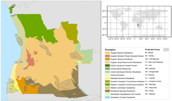
Map of Angola. The 15 WWF ecoregions represented in Angola are displayed together with the network of protected areas (see text for details). doi:10.1371/journal.pone.0103403.g001

Map of Angola showing ecoregions according to Burgess et al. (2004). Records of the Nucras scalaris type series depicted in red, and the new record in orange.
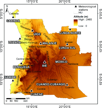
Map of the HUs of Angola. Location of the 12 meteorological stations
1. Multi-hazard exposure
Angola’s main climate and disaster risks include droughts, floods, storms, flash floods, coastal erosion, sea-level rise, soil erosion, land degradation, forest and biodiversity loss, food insecurity, and public-health risks. The World Bank’s Angola Country Climate and Development Report states that the country is already experiencing increasingly severe and frequent climate hazards, including prolonged droughts in the south, while climate-related disasters such as floods, storms, and droughts cost Angola nearly US$1.2 billion between 2005 and 2017. It also reports that droughts alone affect about one million Angolans per year on average. (World Bank)
Angola’s 2025 NDC identifies adaptation as a central national priority because of the country’s vulnerability to prolonged droughts, intense floods, coastal erosion, and biodiversity loss, with resilience actions needed across agriculture, water resources, public health, coastal zones, and other key sectors. (UNFCCC)
2. Drought, water scarcity, and southern Angola vulnerability
Drought is Angola’s most critical slow-onset climate risk, especially in the southern provinces such as Cunene, Namibe, Huíla, Cuando Cubango, and parts of Benguela. Repeated droughts reduce water availability, degrade pasture, weaken livestock, reduce crop yields, increase food insecurity, and force households to adopt negative coping strategies such as distress livestock sales, migration, charcoal production, and reduced food consumption.
The 2012–2016 drought recovery assessment for Angola emphasized longer-term recovery measures for the southern region, including water harvesting, community irrigation, reforestation, drought-resistant crop varieties, sustainable farming practices, livelihood diversification, and actions to reduce deforestation and land degradation. (Service for Foreign Policy Instruments)
3. Flood, flash-flood, and urban vulnerability
Flooding is a major recurrent hazard in Angola, particularly in riverine areas, low-lying settlements, informal urban neighborhoods, and coastal cities. Heavy rainfall can trigger flash floods, river overflow, drainage failure, erosion, road damage, housing losses, water contamination, and disease outbreaks.
Urban flood vulnerability is especially important in Luanda and other fast-growing coastal and peri-urban settlements, where drainage systems, informal housing, waste blockage, settlement expansion in flood-prone areas, and inadequate urban planning increase risk. Coastal cities also face combined risks from flooding, storm surge, sea-level rise, groundwater contamination, and water-supply stress. Research on water-resource management in Angola’s coastal settlements notes that the country’s high vulnerability is increasingly recognized in national climate adaptation planning. (IIED)
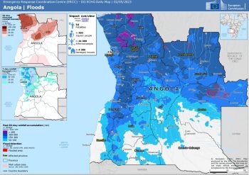
Emergency Response Coordination Centre (ERCC) – DG ECHO Daily Map | 02/05/2023 , EU
4. Coastal vulnerability and sea-level rise
Angola’s Atlantic coastline is exposed to coastal erosion, sea-level rise, coastal flooding, storm surge, saltwater intrusion, and damage to ports, roads, fisheries, housing, tourism assets, and coastal infrastructure. Coastal vulnerability is particularly important because Angola’s major economic and administrative assets are concentrated near the coast, including Luanda and key port and industrial zones.
Earlier climate adaptation analysis identified coastal areas as facing increased damage from storm surges combined with sea-level rise, while heavy rainfall and flooding also increase risks to livelihoods and infrastructure. (research.fit.edu)
5. Agriculture, livestock, and food-security vulnerability
Agriculture is one of Angola’s most climate-sensitive sectors. Smallholder farmers depend heavily on rainfall, local seed systems, soil fertility, access to water, and functioning rural infrastructure. Drought, irregular rainfall, floods, crop pests, soil erosion, livestock disease, and water scarcity can reduce production and deepen rural poverty.
Angola’s NAPA emphasizes the vulnerability of agriculture, especially small-scale farming, and highlights the importance of climate-based agricultural planning, agro-ecological models, locally appropriate seeds, soil and water conservation, forestry, agriculture, and coastal-zone adaptation. (UNFCCC)
6. Sector-specific vulnerability summary
| Sector | Main climate and multi-hazard risks |
|---|---|
| Agriculture and food security | Drought, erratic rainfall, floods, crop failure, pests, soil erosion, reduced yields |
| Livestock and pastoralism | Water scarcity, pasture degradation, livestock mortality, disease, livelihood losses |
| Water resources | Drought, reduced river flows, groundwater stress, flood contamination, poor rural water access |
| Coastal zones | Coastal erosion, sea-level rise, storm surge, saltwater intrusion, infrastructure exposure |
| Urban settlements | Flash floods, drainage failure, informal settlement exposure, water contamination |
| Health | Malnutrition, diarrhoeal disease, malaria and vector-borne disease risks, heat stress |
| Ecosystems and biodiversity | Deforestation, land degradation, soil erosion, biodiversity loss, reduced ecosystem services |
| Infrastructure | Road washouts, bridge damage, flood disruption, coastal asset exposure, water-system damage |
7. Social vulnerability
The most vulnerable groups include smallholder farmers, pastoralists, agro-pastoral households, rural communities in drought-prone southern Angola, low-income urban households, informal settlers, coastal communities, women-headed households, children, older persons, people with disabilities, and households dependent on climate-sensitive agriculture, livestock, fisheries, forests, or informal livelihoods.
Vulnerability is highest where climate exposure overlaps with poverty, weak housing, limited safe water access, low savings, weak rural infrastructure, poor market access, limited insurance, and inadequate access to timely early warning and recovery support.
8. Priority resilience needs
Angola’s resilience agenda should prioritize multi-hazard early warning systems, drought monitoring, flood forecasting, impact-based forecasting, water-security planning, climate-resilient agriculture, drought-resistant crops, livestock and rangeland management, coastal-zone protection, urban drainage improvement, ecosystem restoration, climate-health surveillance, disaster risk financing, and locally led adaptation.
A practical resilience package should include:
| Priority area | Key actions |
|---|---|
| Early warning and anticipatory action | Impact-based warnings for drought, floods, storms, heat, food insecurity, and coastal hazards |
| Drought and water security | Water harvesting, groundwater monitoring, borehole rehabilitation, small-scale irrigation, drought contingency planning |
| Climate-resilient agriculture | Drought-tolerant seeds, agro-climate advisories, soil and water conservation, crop diversification |
| Livestock resilience | Rangeland management, livestock vaccination, fodder systems, water-point protection, livelihood diversification |
| Flood-risk management | River and urban flood mapping, drainage upgrading, flood-safe settlement planning, community preparedness |
| Coastal resilience | Coastal erosion monitoring, mangrove and wetland protection, coastal infrastructure risk screening |
| Health and nutrition resilience | Climate-informed disease surveillance, nutrition support, flood-safe WASH systems |
| Risk governance and financing | Local disaster planning, contingency finance, forecast-based financing, resilient recovery investment |
Relevent Documents :
The National Commission for Civil Protection (CNPC) – A Comissão Nacional de Proteção Civil (CNPC)
and
National Civil Protection and. Firefighter Service (SNPCB) – e o Serviço Nacional de Proteção Civil e Bombeiros (SNPCB)
The Government of Angola recognises the country’s vulnerability to climate change and is aware of the impacts the country has already suffered. Floods, droughts, soil erosion,and rising sea levels are the main effects of climate change in the country, according to a report by the Ministry of Environment.
The main institutional body responsible for DRR and management is the National Commission for Civil Protection, through the DRR Direction.
The Strategic Disaster Risk Prevention and Reduction Plan 2013-2017 refers to a Risk Reduction and Prevention Technical Committee, constituted by the ministerial departments with leadership responsibility in this field. The National Strategy to Climate Change 2018-2030 (ENAC) results from the need to articulate objectives, instruments, and institutions in the pursuit of the latest challenges facing the country.
Climate
Angola is a large African country, located in the southern hemisphere and overlooking the Atlantic Ocean, and its climate is tempered by a cool sea current along the coast and by the altitude in the plateau, which is found in the interior.
The result is a sub-tropical climate almost everywhere. From May to August, ie the austral winter, there is a cool and dry season (called Cacimbo), while in the austral summer, there’s usually a hot and rainy season, which runs from mid-September to April in the north-east, from mid-October to April in the center, from November to March in the south, while along the coast, it only goes from February to April in Luanda, and it’s almost non-existent on the southern coast (which is therefore desert).
The cool sea current that flows along the coast, the Benguela Current, makes the climate mild and dry, at least in the central and southern parts; in the southernmost part of the coast, the climate is even desert. In inland areas, the rains are generally more abundant than on the coast, but here too, they are more abundant in the center and north because of the greater proximity to the Equator.