Research & Development on Multi-Hazard Early Warning System (EWS)
- AI-enabled hazard detection and multi-hazard early warning systems, integrating AI-driven reconnaissance surface observations, IoT sensor-based, and acquisition of crowdsourced weather variables, hazard onset detection, event situational awareness, and hazard hotspot tracking.
- IoT sensor, AI, UAV, and drone–driven monitoring systems for climate change and multi-hazard exposure, risk, and vulnerability assessment of climate-vulnerable productive sectors, including agriculture, livestock, fisheries, water resources, environment, forests, ecology and biodiversity, and human and food security.
- IoT sensor, AI, UAV, and drone–enabled rapid post-disaster loss, damage, and needs assessment (RPDNA) to support timely response, recovery planning, and evidence-based decision-making.
Overall Goal
To design, develop, and operationalize a robust, AI- and ICT-driven multi-hazard early warning and disaster risk management system integrating satellite, UAV/Drone, ground sensors, and human intelligence, to minimize losses and damages (L&Ds) and protect vulnerable communities and ecosystems.
Specific Objectives
- Develop a multi-hazard early warning system (EWS) integrating advanced sensors, AI models, and multi-source data.
- Design and test an AI-driven Rapid Post-disaster Damage, Loss, and Needs Assessment (RPDNA) system.
- Conceptualize and prototype a new generation weather satellite system with multi-sensor payloads tailored for hazardous weather and risk element detection.
- Develop an integrated hazard detection and reconnaissance architecture using UAVs/Drones, satellites, and ground-based sensors.
- Design and validate AI-supported forecast-driven anticipatory early action protocols for humanitarian and climate frontline actors.
- Build a unified AI-ICT platform that fuses satellite anomalies, ground sensors, AI alerts, and human observations into a single operational EWS.
- Develop a monitoring system for environmental degradation and critical ecosystems (sanctuaries, estuaries, reserve forests, ecologically critical areas, agro-ecology).
R&D Components :
Research Package 1: Multi-Hazard Early Warning System (Core R&D)
Focus:
Robust research and development on a multi-hazard EWS that can handle cyclones, floods, landslides, heatwaves, storm surges, wildfires, etc.
Key Tasks:
- Define priority hazards, risk indicators, and thresholds.
- Design architecture for real-time data ingestion from:
- Weather satellites
- UAV/Drone platforms
- Ground-based sensors (hydro-met, seismic, air quality, etc.)
- Human/field reports
- Develop hazard-specific AI models for:
- Nowcasting and short-term forecasting
- Anomaly detection in environmental and weather parameters
- Integrate outputs into operational dashboards for:
- Weather Department
- National Disaster Management Organization (NDMO)
- Humanitarian coordination centers
Outputs:
- System architecture & prototype multi-hazard EWS.
- Algorithms and thresholds for multiple hazard types.
- Operational guidelines and SOPs for EWS activation.
Research Package 2: AI-Driven Rapid Post-Disaster Damage, Loss, and Needs Assessment (RPDNA)
Focus:
An AI-driven system to conduct Rapid Post-disaster Damage, Loss, and Needs Assessment (RPDNA).
Key Tasks:
- Use before/after satellite imagery, UAV reconnaissance imagery, and ground photos to:
- Detect building damage, road blockage, crop loss, and infrastructure disruption.
- Develop computer vision models for:
- Change detection
- Damage classification (none, minor, major, destroyed)
- Link RPDNA outputs to:
- Loss & Damage (L&D) estimates
- Immediate needs (shelter, WASH, health, food, logistics)
- Create RPDNA dashboards for NDMO, government agencies, and humanitarian clusters.
Outputs:
- AI-based RPDNA tool and interface.
- Standardized RPDNA methodology and indicators.
- Data-sharing protocols with humanitarian actors.
Research Package 3: New Weather Satellite Design with Multi-Sensor Payload
Focus:
New design of weather satellite with installations of multiple sensors for detecting hazardous weather variations and multi-hazard risk elements, capable of sending real-time alerts to the Weather Department and NDMO.
Key Tasks:
- Define sensor suite:
- Multispectral/hyperspectral imagers
- Microwave radiometers
- Lightning mapper
- Atmospheric sounders
- Environmental monitoring bands (aerosols, dust, smoke, ash)
- Specify performance requirements:
- Spatial, temporal, and spectral resolution
- Latency for near-real-time alerts
- Design onboard AI concepts for:
- Edge processing
- Onboard anomaly detection
- Priority downlink of critical data
- Integrate alert channels (e.g., direct broadcast to national receiving stations and NDMO).
Outputs:
- Concept design document for next-generation weather satellite.
- Sensor requirement specifications for hazardous weather and risk monitoring.
- Data format and downlink protocol specifications.
Research Package 4: Multi-Platform Hazard Detection (Satellite + UAV/Drone + Recon UAV + Ground Sensors)
Focus:
Research a robust hazard detection system that fuses information from UAV/Drone, Satellite sensors, Reconnaissance UAVs, ground sensors, etc.
Key Tasks:
- Map the roles of each platform:
- Satellites – wide-area, continuous monitoring
- UAV/Drone – high-resolution local reconnaissance
- Ground sensors – localized, high-precision, real-time data
- Develop data fusion algorithms for combining:
- Spaceborne
- Airborne
- Ground-based datasets
- Optimize tasking logic: AI triggers a UAV reconnaissance mission when:
- Satellite detects anomalies
- Ground sensor crosses threshold
- Human observation report is validated
Outputs:
- Hazard detection and reconnaissance workflow.
- Data fusion algorithms and operational prototype.
- Procedures for coordinated satellite–UAV–ground deployment.
Research Package 5: AI-Supported Forecast-Driven Anticipatory Early Action Protocol
Focus:
Conduct research on an AI-system-supported, forecast-driven, precision early warning + anticipatory action protocol, synchronized with risk and vulnerability elements and risk repository databases.
Key Tasks:
- Build a risk repository database:
- Exposure (population, housing, infrastructure, crops)
- Vulnerability (poverty, disability, access to services, protection needs)
- Historical impact and L&D data
- Link forecast outputs (probabilistic hazard forecasts) with:
- Triggers for anticipatory actions
- Pre-defined response plans and financing windows
- Design AI decision-support tools that:
- Propose where, when, and what anticipatory actions should be taken
- Optimize resource allocation (cash, NFIs, evacuation, protection measures)
- Co-create protocols with:
- Humanitarian actors
- Government agencies
- Local “climate frontline” communities and organizations
Outputs:
- Forecast-based financing/early action trigger model.
- Anticipatory action SOPs and protocol.
- Risk and vulnerability repository and interface.
Research Package 6: AI-ICT System for Integrated Reconnaissance & Early Warning
Focus:
AI and ICT system design for Reconnaissance (satellite, Drone, UAV, ground-level sensors) of rapidly developing hazardous conditions, synthesizing multiple sources of datasets and building a robust AI-ICT-driven EWS.
Data sources to be synchronized:
- Satellite-detected parametric anomalies
- Ground-level sensor anomalies
- AI-processed and generated alerts
- Human observation (crowdsourced, field teams)
- UAV/Drone reconnaissance data
Key Tasks:
- Design a unified data platform:
- Real-time ingestion
- Harmonization and standardization of formats
- Metadata and quality flags
- Develop AI engines for:
- Multi-source anomaly correlation
- Confidence scoring and false-alarm reduction
- Automatic generation of coherent alerts and situation summaries
- Implement role-based dashboards for:
- Weather Dept, NDMO, line ministries
- Humanitarian actors and local authorities
Outputs:
- Integrated AI-ICT EWS platform (prototype).
- APIs and data-sharing standards.
- Training materials and capacity-building modules.
Research Package 7: Environmental Degradation and Ecosystem Monitoring System
Focus:
System design for monitoring AI-driven UAV/Drone/sensor-based environmental degradation in:
- Wildlife sanctuaries
- Estuaries and coastal zones
- Reserve forests
- Ecologically critical areas (ECA)
- Protected/conservation areas
- Agro-ecological zones
Key Tasks:
- Define ecological indicators:
- Deforestation, land cover change, erosion
- Wetland shrinkage, salinity intrusion
- Habitat fragmentation, fire scars
- Crop health and agro-ecological stress
- Develop satellite + UAV monitoring workflows:
- Regular baseline mapping
- Event-based reconnaissance (e.g., after storms, floods)
- Design AI models for:
- Land cover classification
- Degradation trend analysis
- Hotspot identification
- Integrate outputs into EWS as slow-onset hazard signals (e.g., long-term environmental degradation increasing disaster risk).
Outputs:
- Ecosystem monitoring system prototype.
- Ecological risk layers integrated into the risk repository.
- Maps and dashboards for environmental authorities.
- Cross-Cutting Themes
- Data Governance & Interoperability
Open standards, APIs, and data-sharing agreements among the Weather Dept, NDMO, and humanitarian actors. - Ethics, Privacy, and Community Engagement
Responsible AI, community participation, inclusion of marginalized groups. - Capacity Building & Sustainability
Training for government, local universities, and humanitarian agencies to run and maintain the systems.
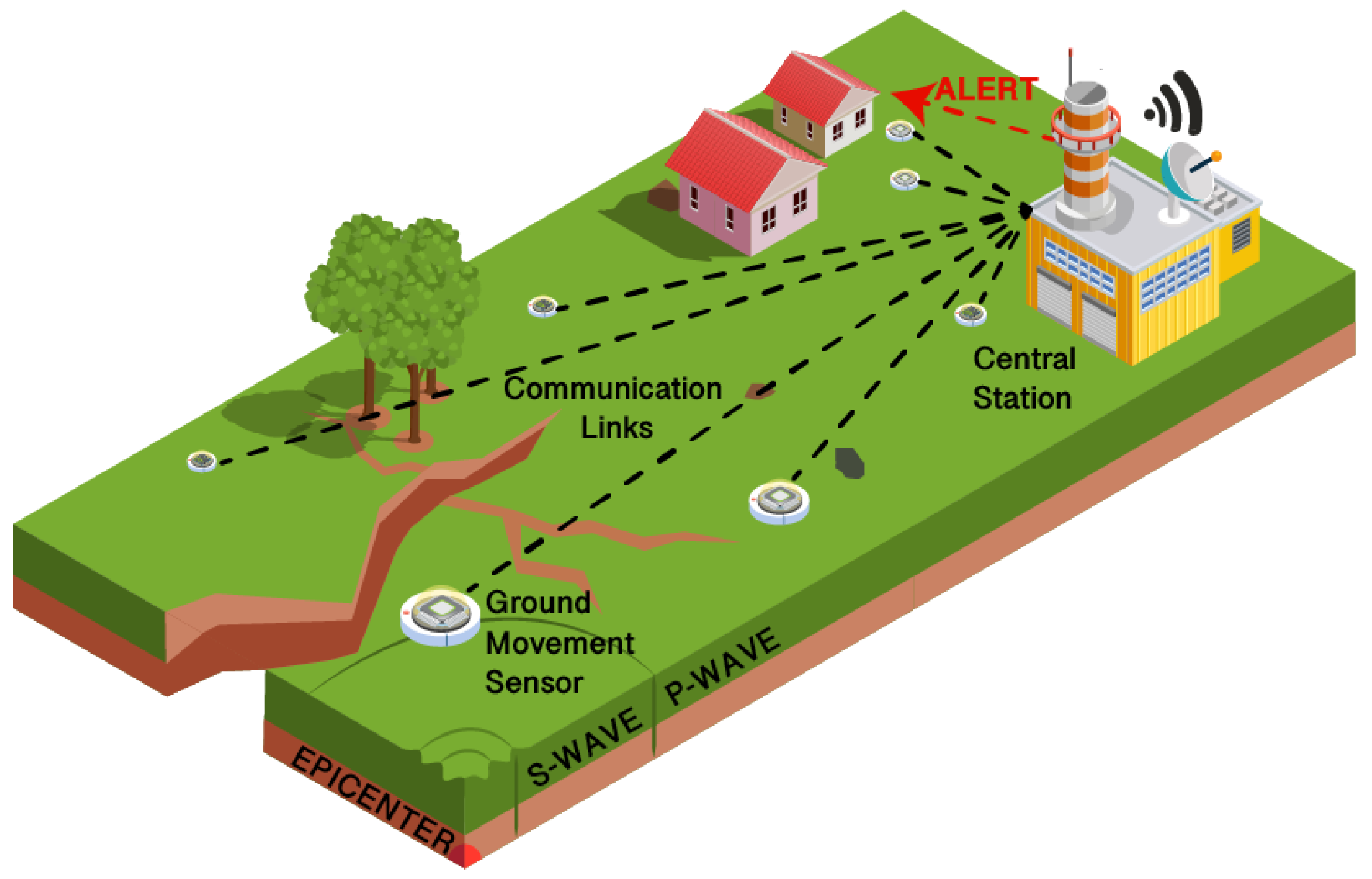
Figure: Internet of Things Solutions for Early Warning Systems: A Review (by  Marco Esposito ,Lorenzo Palma ,Alberto Belli ,Luisiana Sabbatini and Paola Pierleoni
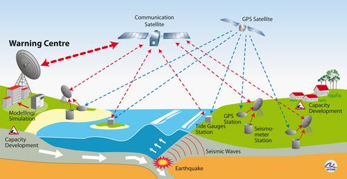
Technical concept of GITEWS 
|
Please Support Research projects :
Seeking partnerships, collaboration, and support from international donor agencies, global climate foundations, glocal R&D organizations, and global multi-national enterprises to provide financial support for conducting extensive research, robust EWS system design, IT programming, and AI system development.
The Multi-hazard Early Warning System Design & Implementation Center (MHEWC) www.mhewc.org engaged in Research and Development (R&D) to develop L&D assessment tools to quantify the ground-level elements impacted by disasters using GIS, RS (SAR image) & GPS tools, and UAV (drone, aerial photographs) captured elements to compare pre- & post-disaster impact levels and develop a strategy on how to minimize L&Ds. Please finance MHEWC to create the most advanced tools (GIS, RS, GPS, drone/UAV-captured elements, repository database queried by Artificial Intelligence) to support the sector department in minimizing L&Ds.
R&D on hazard detection, automated public alerts, command & control systems on emergency preparedness, evacuation deployment for lifesaving, extent of areas and L&Ds elements, and overall combat readiness(inclusive social participatory dynamics) for addressing multi-hazards, disaster threats, and emergencies.
Pleading for funds from climate funding windows, foundations, multinational companies-led CSRs, the UN, and INGOs, etc., please provide funds to carry out much-needed R&D to detect threats of impending dangerous weather events, instrumentalize the EOC/Command & control room with robust multi-hazard early warning systems, and enhance the hazard-combat readiness of inclusive social-participatory dynamics forces to combat disasters.
Seeking funds for establishing a big complex of the Multi-hazard Early Warning System Design & Implementation Center (MHEWC)