Climate risk and vulnerabilities of the Philippines
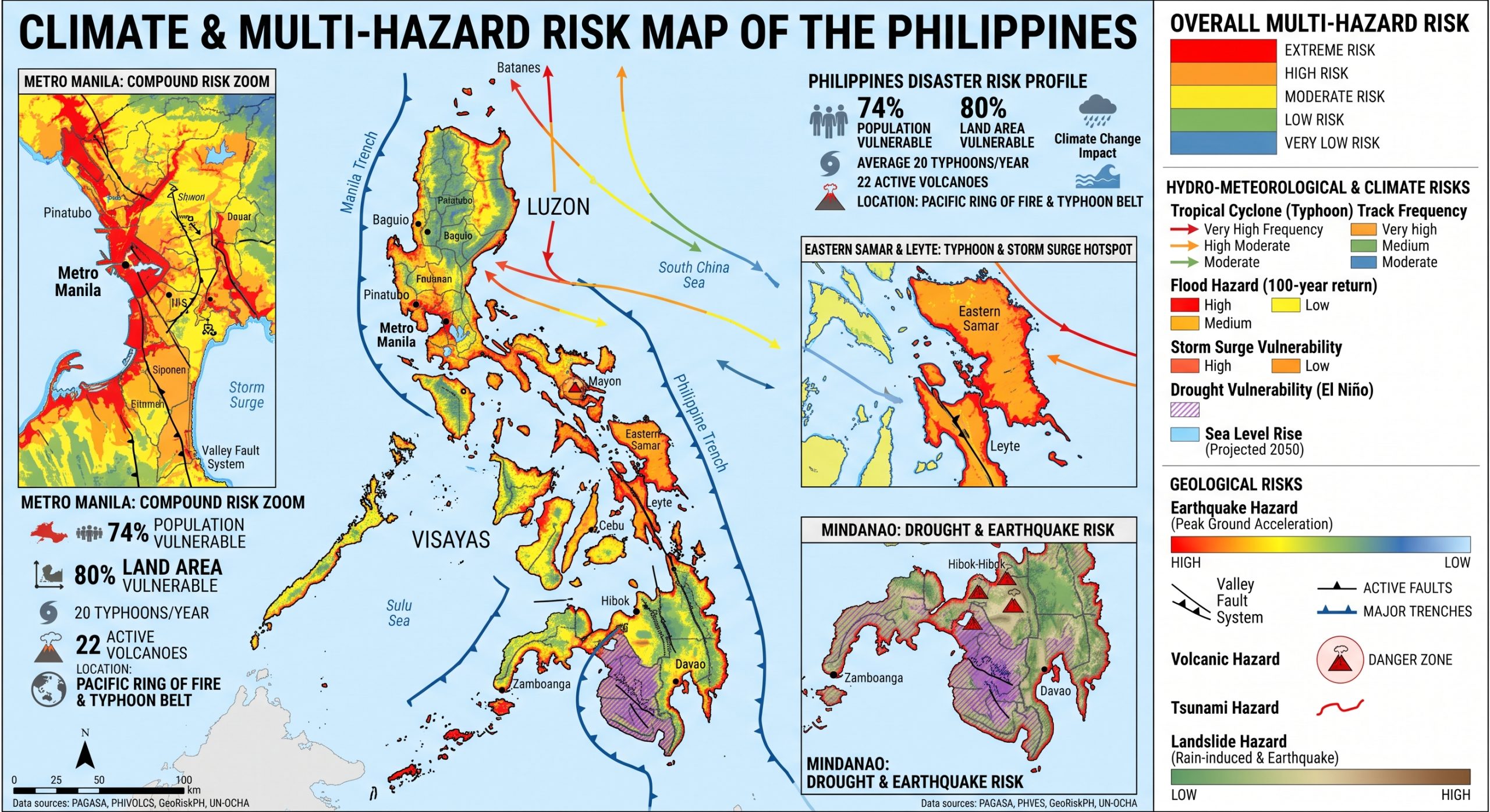
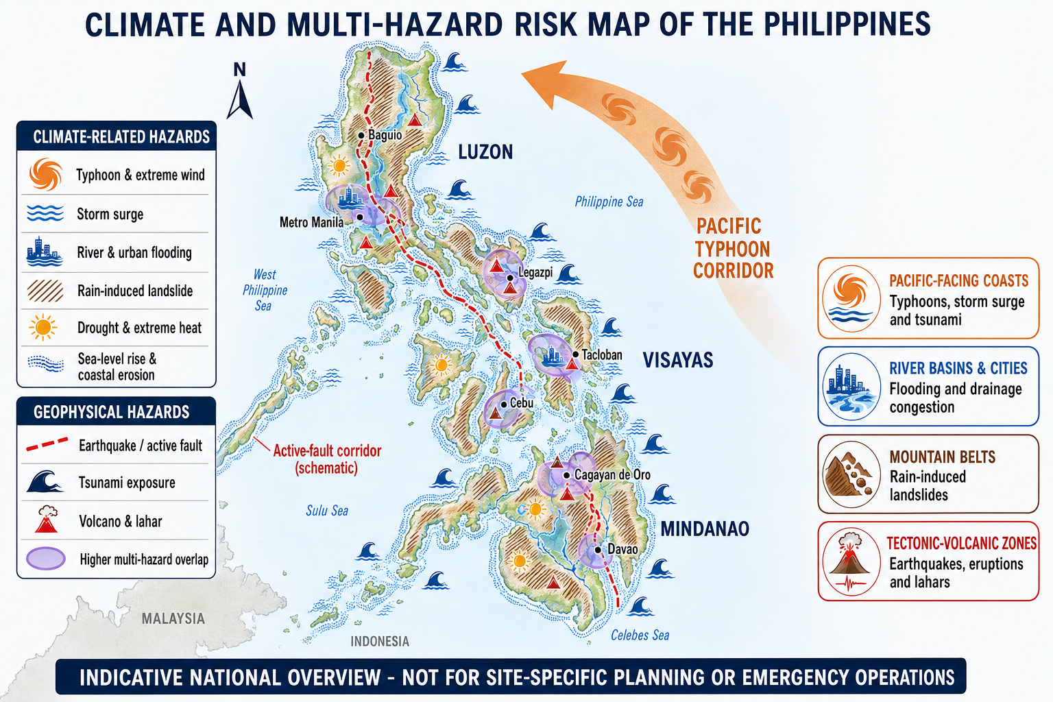
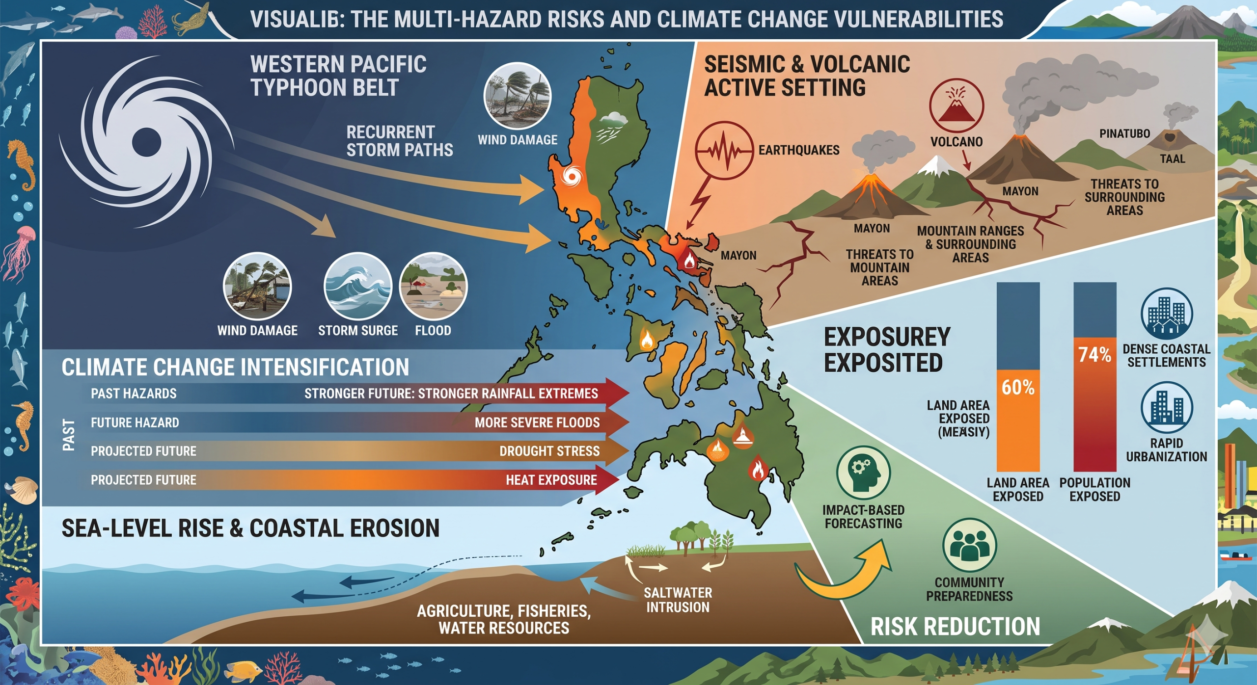
The Philippines is one of the world’s most exposed countries to climate and multi-hazard risks because of its archipelagic geography, location in the western Pacific typhoon belt, long coastline, mountainous and volcanic terrain, active seismic setting, dense coastal settlements, rapid urbanization, and dependence on climate-sensitive sectors such as agriculture, fisheries, water resources, tourism, transport, energy, health, and coastal ecosystems.
The Philippines is highly exposed and vulnerable to climate change and multi-hazard risks due to its archipelagic geography, long coastline, western Pacific typhoon exposure, active seismic and volcanic setting, mountainous terrain, dense coastal and urban settlements, and dependence on climate-sensitive livelihoods. The country faces recurrent and severe risks from typhoons, storm surges, coastal flooding, riverine and urban floods, flash floods, landslides, droughts, heat stress, sea-level rise, coastal erosion, saltwater intrusion, earthquakes, tsunamis, volcanic eruptions, and ecosystem degradation. Climate change is expected to intensify these vulnerabilities through stronger rainfall extremes, more severe storm and flood impacts, sea-level rise, drought stress, heat exposure, water-security pressures, and growing risks to agriculture, fisheries, infrastructure, health, ecosystems, and vulnerable communities. Strengthening multi-hazard early warning systems, impact-based forecasting, coastal protection, flood and landslide risk reduction, earthquake and tsunami preparedness, climate-resilient agriculture, ecosystem-based adaptation, disaster risk financing, and locally led community preparedness is essential to reduce losses and protect the Philippines’ development gains.
The Philippines faces a very wide hazard profile. Major risks include typhoons, tropical storms, floods, storm surges, landslides, earthquakes, volcanic eruptions, tsunamis, droughts, extreme heat, coastal erosion, and sea-level rise. GFDRR describes the Philippines as among the countries with the greatest exposure to natural disaster risk worldwide, with earthquakes, typhoons, flooding, volcanic eruptions, and landslides all presenting major threats. (GFDRR)
The World Bank Climate Change Knowledge Portal notes that the Philippines is highly prone to disasters triggered by natural hazards, with estimates indicating that around 60% of land area and 74% of the population are exposed to multiple hazards. (Climate Change Knowledge Portal) This makes disaster risk a central development issue rather than only an emergency-response concern.
Climate Change Vulnerability Mapping for Southeast Asia
Posted by Dave Petley
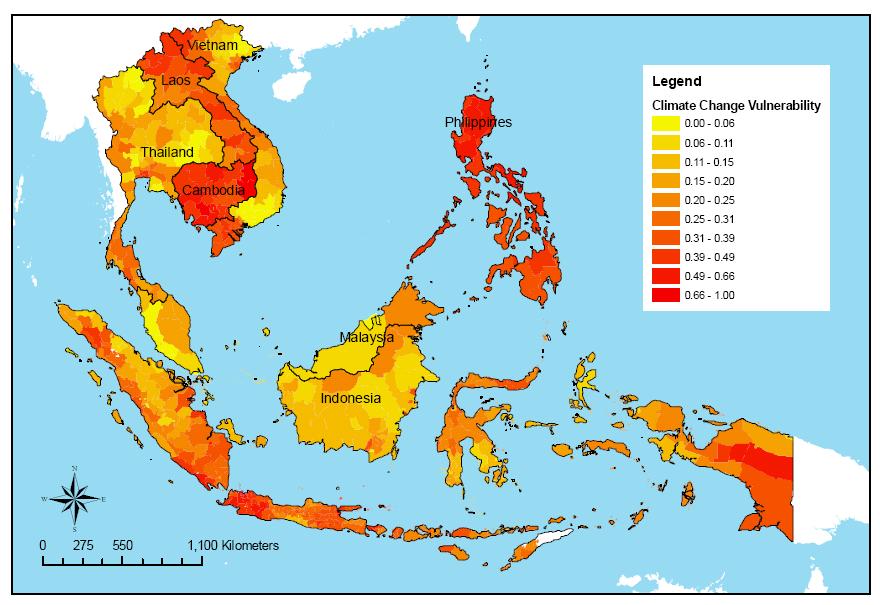
A very interesting report was released last week by the Economy and Environment Program for Southeast Asia (EEPSEA) in which an attempt has been made to map the pattern of vulnerability across the region to climate change. The aim of the project, for which the report is available online, was to “identify which regions in Southeast Asia are the most vulnerable to climate change.” This is a fairly bold thing to try to do, so lets take a look at what they have achieved and how they have done so.
The researchers have taken as a starting point maps of five hazards – cyclones, drought, floods, landslides and coastal inundation (sea level change). In each case they have used an external dataset to indicate the hazard associated with each of these events – so, for example, for landslides they have used the NGI landslide hazard maps produced in the World Bank Natural Disaster Hotspots project (Fig. 1), whereas for sea level change they have modelled the inundation associated with a 5 m increase in sea level.
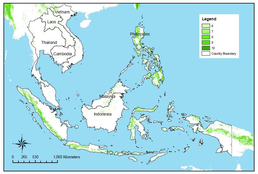
For each hazard a scale of 1-10 has been used, with 10 being highest hazard and 1 the lowest. For each cell on the map, the average score across the five hazards was then taken as an indication of the overall hazard. I will return to this below. The outcome of this analysis is termed the “Multiple Climate Hazard Index”. The resultant map is shown in Fig. 2 below.

This map has then been combined with data for population density (incorporating areas that are ecologically protected) and “adaptive capability” (defined as “the degree to which adjustments in practices, processes, or structures can moderate or offset potential damage or take advantage of opportunities (from climate change).” The latter has used expert judgement to create an index based upon data on education, poverty, income inequality and suchlike. These three indicators have then been averaged to determine the level of vulnerability to climate change (Fig. 3).
2. Climate change as a risk multiplier
Climate change is increasing the intensity and complexity of risk in the Philippines. The country already experiences severe losses from tropical cyclones, floods, landslides, droughts, and coastal hazards, while climate change is expected to worsen rainfall extremes, sea-level rise, heat stress, water insecurity, and ecosystem degradation. The Government’s climate information platform identifies key climate-change impacts including rainfall-pattern changes, droughts, biodiversity and food-security threats, sea-level rise, public-health risks, and increased vulnerability among groups such as women and Indigenous peoples. (NICCDIES)
Recent scientific attribution also points to worsening tropical cyclone conditions. Reuters reported that climate change has increased the likelihood of severe typhoon conditions affecting the Philippines, with warmer oceans contributing to stronger rainfall and wind impacts. (Reuters)
3. Typhoon, storm-surge, and coastal vulnerability
Typhoons are among the Philippines’ most damaging hazards. The country is frequently affected by tropical cyclones that bring destructive winds, extreme rainfall, storm surges, coastal flooding, landslides, river flooding, and infrastructure damage. Coastal provinces, small islands, low-lying settlements, fishing communities, ports, tourism zones, and coastal roads are especially exposed.
Storm surge is a major concern in eastern and central coastal areas, particularly where low-lying settlements, weak housing, limited evacuation access, and exposed livelihoods overlap. Typhoon-related impacts can damage homes, schools, health facilities, power systems, roads, bridges, crops, fishing boats, aquaculture ponds, and water systems.
4. Flood, flash-flood, and landslide vulnerability
Floods are recurrent across the Philippines, including riverine floods, flash floods, urban floods, and coastal floods. Heavy rainfall from typhoons, monsoon systems, localized storms, poor drainage, river overflow, deforestation, land-use change, and settlement in floodplains all increase flood risk.
Landslides are also severe, especially in mountainous and deforested areas, road-cut slopes, mining zones, upland settlements, and areas exposed to typhoon-triggered rainfall. Floods and landslides often occur together, creating cascading impacts on housing, roads, bridges, agriculture, water systems, electricity, schools, health services, and emergency access.
5. Earthquake, tsunami, and volcanic vulnerability
The Philippines is located along the Pacific Ring of Fire, making it highly exposed to earthquakes, volcanic eruptions, and tsunamis. GFDRR identifies earthquakes and volcanic eruptions as major hazards for the country alongside typhoons, floods, and landslides. (GFDRR)
Recent seismic events underline the country’s continuing earthquake exposure. Reuters reported that a powerful 7.8-magnitude earthquake struck off Sarangani province in southern Philippines in June 2026, causing deaths, injuries, damaged buildings, power and water disruption, aftershocks, and tsunami warnings. (Reuters)
Earthquake and volcanic risks threaten housing, schools, hospitals, roads, bridges, ports, power systems, water systems, and telecommunications. Volcanic eruptions can also generate ashfall, lahars, pyroclastic flows, crop damage, water contamination, respiratory illness, displacement, and transport disruption.
6. Drought, El Niño, heat, and water-security vulnerability
Drought and heat stress are growing concerns, particularly during El Niño periods. Drought affects agriculture, drinking water, hydropower, irrigation, fisheries, livestock, forests, and household food security. Areas dependent on rainfed agriculture and shallow water sources are especially vulnerable.
Heat stress affects health, labour productivity, agriculture, electricity demand, and urban living conditions. Outdoor workers, farmers, fisherfolk, construction workers, street vendors, children, older persons, pregnant women, and people with chronic illnesses face heightened heat-related risks.
7. Agriculture, fisheries, and food-security vulnerability
Agriculture and fisheries are highly climate-sensitive. Rice, maize, coconut, banana, sugarcane, vegetables, livestock, aquaculture, and coastal fisheries are exposed to typhoons, floods, droughts, heat stress, salinity intrusion, pests, diseases, and market disruption.
| Sub-sector | Main climate and hazard risks |
|---|---|
| Rice and maize | Floods, drought, heat stress, crop-calendar disruption, pest outbreaks |
| Coconut, banana, and high-value crops | Typhoon wind damage, flooding, landslides, disease outbreaks |
| Livestock | Heat stress, disease, water scarcity, feed shortages, flood losses |
| Fisheries | Storms, rough seas, damaged boats, reef degradation, ocean warming |
| Aquaculture | Flooding, salinity shifts, disease, storm surge, pond damage |
| Rural livelihoods | Crop loss, debt, food-price shocks, market-access disruption |
8. Coastal, marine, and ecosystem vulnerability
The Philippines’ coastal and marine ecosystems are highly exposed to sea-level rise, ocean warming, acidification, coral bleaching, coastal erosion, mangrove degradation, and storm damage. These ecosystems are central to fisheries, tourism, shoreline protection, biodiversity, and food security.
Mangroves, coral reefs, seagrasses, watersheds, and forests provide natural protection against storms, floods, erosion, and landslides. Their degradation increases disaster risk by reducing natural buffers and weakening livelihood systems.
9. Urban and infrastructure vulnerability
Major urban areas such as Metro Manila, Cebu, Davao, Cagayan de Oro, Iloilo, Tacloban, Zamboanga, and other rapidly growing cities face combined risks from urban flooding, drainage congestion, heat stress, earthquakes, landslides, coastal flooding, and infrastructure overload.
Urban vulnerability is highest where exposure overlaps with:
| Vulnerability driver | Risk implication |
|---|---|
| Informal settlements | Weak housing, poor drainage, flood and landslide exposure |
| Coastal expansion | Storm surge, sea-level rise, erosion, tidal flooding |
| Aging infrastructure | Road, bridge, drainage, water, and power disruption |
| High-density areas | Emergency-access constraints and heat-island effects |
| Low-income households | Limited savings, low insurance coverage, slower recovery |
10. Social vulnerability
The most vulnerable groups include low-income households, informal settlers, coastal communities, smallholder farmers, fisherfolk, Indigenous peoples, upland communities, women-headed households, children, older persons, people with disabilities, migrants, and communities living in flood-prone, landslide-prone, drought-prone, coastal, seismic, or volcanic-risk areas.
Vulnerability is highest where hazard exposure overlaps with poverty, weak housing, insecure land tenure, limited livelihood options, poor access to early warning, limited evacuation capacity, and low access to recovery finance.
11. Priority resilience needs
The Philippines’ resilience agenda should prioritize multi-hazard early warning systems, impact-based forecasting, typhoon and storm-surge preparedness, flood and landslide risk reduction, earthquake and tsunami preparedness, volcanic monitoring, drought early warning, heat-health planning, climate-resilient agriculture, coastal-zone management, ecosystem-based adaptation, resilient infrastructure, disaster risk financing, and locally led adaptation.
The Philippines’ National Adaptation Plan aims to reduce climate vulnerability by strengthening adaptive capacity and integrating adaptation into policies, programs, and government activities. (NICCDIES)
Practical resilience package
| Priority area | Key actions |
|---|---|
| Early warning and anticipatory action | Impact-based warnings for typhoons, floods, storm surge, landslides, drought, heat, earthquakes, tsunamis, and volcanic hazards |
| Coastal resilience | Storm-surge mapping, mangrove restoration, coastal zoning, evacuation routes, resilient shelters |
| Flood and landslide risk reduction | Basin forecasting, drainage upgrading, slope stabilization, landslide susceptibility mapping |
| Geophysical risk management | Earthquake-safe construction, tsunami evacuation planning, volcanic hazard monitoring |
| Climate-smart agriculture | Drought-, flood-, heat-, and salinity-tolerant crops; climate advisories; crop insurance |
| Urban resilience | Drainage improvement, risk-informed land-use planning, informal settlement upgrading, heat-risk planning |
| Ecosystem-based adaptation | Mangrove, reef, watershed, and forest restoration for natural protection |
| Risk financing and recovery | Contingency finance, insurance, forecast-based financing, shock-responsive social protection |
The National Disaster Risk Reduction and Management Council (NDRRMC)- Philippines https://ndrrmc.gov.ph
The National Disaster Risk Reduction & Management Council (NDRRMC), formerly known as the National Disaster Coordinating Council (NDCC), is a working group of various government, non-government, civil sector, and private sector organizations of the Government of the Republic of the Philippines established by Republic Act 10121 of 2009. The Office of Civil Defense administers it under the Department of National Defense. The Council is responsible for ensuring the protection and welfare of the people during disasters or emergencies.
The NDRRMC plans and leads the guiding activities in the field of communication, warning signals, emergency, transportation, evacuation, rescue, engineering, health and rehabilitation, public education, and auxiliary services such as firefighting and the police in the country.
Member Agencies
National Mapping and Resource Information Authority (NAMRIA) |
Department of Human Settlements and Urban Development(DHSUD) |
League of Provinces of the Philippines (LPP) |
League of Cities of the Philippines (LCP) |
Local Flood Early Warning Systems in the Philippines
The Challenge
Extreme local weather events, such as heavy rainfalls that are limited to certain regions, are increasing in their frequency and intensity, but are often not recorded by the national warning centres. In small and medium-sized river basins, water levels may rise rapidly, and often do not leave enough time to issue warning alerts. Insufficient registration of such recurring events, in addition to limited coping strategies, pose major challenges to local government units and their communities.
Objectives
To avoid damage and losses related to flood risks, we offered a flexible, robust and cost-effective local early warning system that can be operated by local government units to enable communities to respond to warning messages appropriately and in a timely manner. Thus, evacuations can be initiated and material goods can be protected. In this way, a comprehensive and sustainable contribution to disaster risk management was made at the local level.
Approach
The Deutsche Gesellschaft für Internationale Zusammenarbeit (GIZ) GmbH has developed an integrated approach for Local Flood Early Warning Systems (LFEWS) in the Philippines. LFEWS combine the capacities of the national meteorological authority, local government units and the communities. The approach focuses on small to medium-sized river basins and is tailored to local conditions. Where necessary, the system may be supplemented with GIS data and satellite information. Data on the extent and frequency of rising water levels provide important information for risk maps that can be used to prepare or adapt land-use plans.
The prevented damages and losses associated with flood events significantly ease the financial burden on private households and district budgets and usually amortises the costs of running and maintaining the LFEWS within a few years.
Early warning must be understood as a system. A complete and effective early warning system comprises four inter-connected components. The LFEWS approach includes all four pillars of an effective “end-to-end” early warning system:

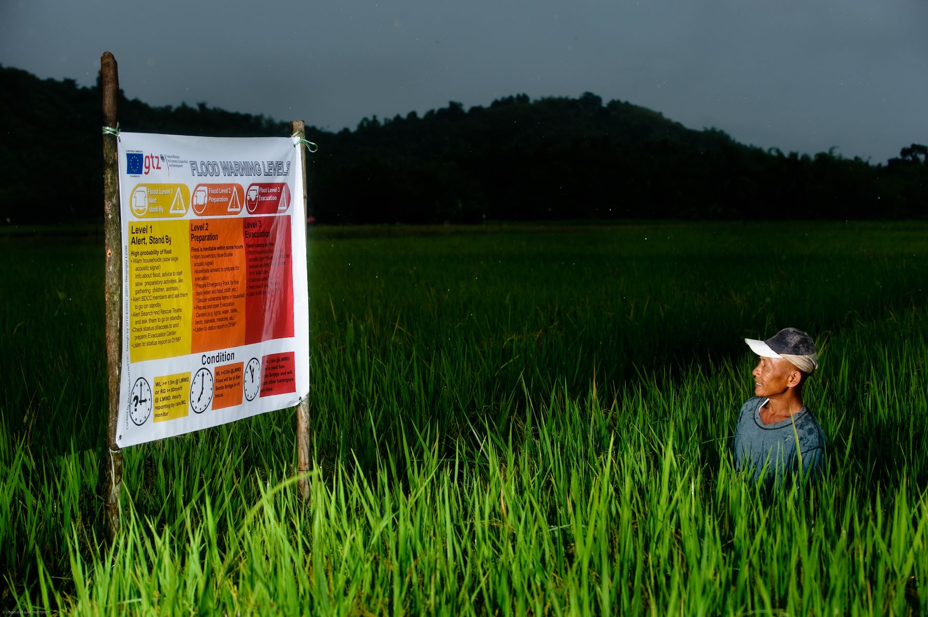
When the early warning system measures a potentially dangerous rise of the upstream water level as a result of heavy rain, the information is automatically sent to a local operations centre, which in turn informs the districts at risk. From there, a warning message based on standardised alert levels is disseminated to the communities, using simple but effective communication channels. Disaster response teams and authorities in the districts have been trained and equipped to support the process. A network of evacuation centres provides shelter if a disaster strikes.
Within the framework of the GIDRM, the LFEWS approach was replicated in other regions that present a similar risk profile. A pilot project in Vietnam was launched in 2014; fact-finding missions have also been conducted in Myanmar and Thailand.
In addition to the customized replication of this proven approach, the integration of innovative real-time forecasting technologies is planned within the context of GIDRM I. Furthermore, a systematic connection with national early warning systems, such as for tsunamis or cyclones needs to be ensured. The institutional capacities that are established at the local government unit level through LFEWS can facilitate this process.
Besides further improvements in local early warning relating to heavy rainfall and flash floods, another focus was on the integration of landslides and appropriate and precise landslide early warning mechanisms. Pilot measures have been running since 2010 to test the performance of motion sensors.
Partners
In close cooperation with the Philippine partners, including local government units as well as the Department of Science and Technology (DOST) and the Philippine Atmospheric, Geophysical and Astronomical Services Administration (PAGASA), GIZ has implemented 16 LFEWS in twelve provinces across the country, from which 750,000 people have been benefiting since 2007.
To further develop the local early warning system approach, GIDRM I closely cooperated with the University of Potsdam in Germany.
GIDRM I also collaborated with three partner projects in Thailand, Vietnam and the Philippines.
© Dave Martinez
More Information
For more information on GIDRM I and early warning systems, please visit our resources.
Improved Management of Extreme Events through Ecosystem-based Adaptation in Watersheds (ECOSWat) (commissioned by BMUB)
Flood Management and Drainage of Medium-sized Cities to Adapt to Climate Change (commissioned by BMZ)
Programme on Sustainable Management of Natural Resources (ENRD) (commissioned by BMZ)