Climate risk and vulnerabilities of Thailand (Detailed)
Thailand is highly vulnerable to climate change and multi-hazard risks due to its monsoon climate, extensive river basins, low-lying central plains, long coastlines along the Gulf of Thailand and Andaman Sea, rapidly urbanizing settlements, climate-sensitive agriculture, tourism dependence, and exposure of major economic assets to floods, droughts, coastal erosion, sea-level rise, heat stress, landslides, storms, wildfires, and water scarcity. Floods are widely identified as Thailand’s most significant natural hazard in terms of human and economic impacts. (ADB)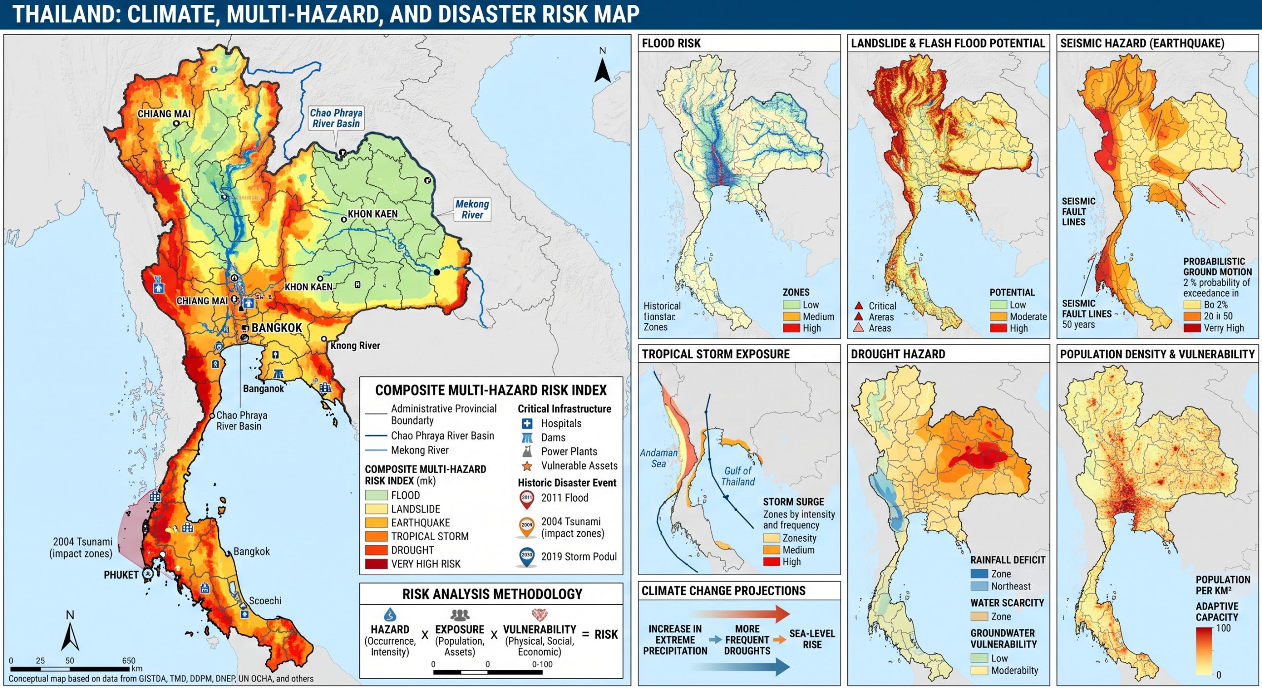
Thailand is highly exposed and vulnerable to climate change and multi-hazard risks due to its monsoon climate, flood-prone river basins, low-lying central plains, coastal exposure, rapid urbanization, climate-sensitive agriculture, tourism dependence, and concentration of people, industry, infrastructure, and services in hazard-prone areas. The country faces recurrent risks from riverine floods, flash floods, urban flooding, droughts, extreme heat, landslides, storms, coastal erosion, sea-level rise, saltwater intrusion, wildfires, water scarcity, and climate-sensitive health impacts. Climate change is expected to intensify these vulnerabilities through heavier rainfall extremes, more severe flood and drought events, rising temperatures, prolonged heat stress, coastal inundation, storm-surge impacts, salinity intrusion, and growing pressure on agriculture, fisheries, tourism, water resources, infrastructure, public health, and vulnerable communities. Strengthening multi-hazard early warning systems, impact-based forecasting, flood and drought risk management, coastal protection, climate-resilient agriculture, urban drainage, heat-health planning, tourism resilience, disaster risk financing, and locally led adaptation is essential to reduce losses and protect Thailand’s development gains.
1. Multi-hazard exposure
Thailand’s main hazards include floods, droughts, storms, landslides, coastal erosion, sea-level rise, heatwaves, wildfires, water scarcity, and localized seismic or tsunami exposure. UNDRR identifies Thailand’s prevalent hazards as flooding, cyclones, landslides, wildfires, extreme heat, and associated water scarcity. (UNDRR)
The country’s flood risk is especially concentrated in the Chao Phraya Basin, which contains major agricultural, urban, industrial, and transport assets. The World Bank’s Thailand CCDR notes that the country’s vulnerability to flooding is largely concentrated in this basin, and projected climate change could make severe historical flood events much more frequent. (World Bank)
2. Climate change as a development risk multiplier
Climate change poses a major macroeconomic and development risk for Thailand. The World Bank CCDR assesses physical risks from floods, droughts, heat stress, and other climate-related disasters, and estimates that climate change could reduce Thailand’s GDP by 7–14% by 2050 without decisive adaptation. It also finds that investments in flood mitigation, coastal protection, water security, and cooling could raise annual GDP by 4–5% by 2050 relative to business-as-usual. (World Bank)
Thailand also faces major tail risks from rare but severe disasters. The 2011 floods caused damage equivalent to 12.6% of GDP, or about US$46.5 billion, and disrupted production by around 5% of GDP; the World Bank notes that climate change could increase the intensity and recurrence of similar events. (World Bank)
3. Flood, urban flood, and landslide vulnerability
Flooding is Thailand’s dominant disaster risk. Riverine floods affect central plains and major basins; flash floods affect steep northern, western, and southern catchments; and urban flooding affects Bangkok, peri-urban areas, and secondary cities where intense rainfall overwhelms drainage systems.
Detailed Climate and Multi-Hazard Risk and Vulnerability Profile of Thailand
- Executive risk overview
Thailand has a complex multi-hazard risk landscape shaped by tropical monsoons, major transboundary river systems, extensive floodplains, mountainous northern and western terrain, a long coastline on the Gulf of Thailand and the Andaman Sea, rapid urbanization, intensive agriculture, globally connected manufacturing corridors and a large climate-sensitive tourism economy.
The country is exposed to:
- riverine, flash, pluvial and coastal flooding;
- drought and seasonal water scarcity;
- extreme heat and humid heat stress;
- tropical storms, depressions and monsoon windstorms;
- coastal erosion, sea-level rise and saltwater intrusion;
- landslides, debris flows and soil erosion;
- forest fires, agricultural burning, haze and PM2.5 pollution;
- earthquakes and tsunamis;
- lightning, hailstorms and damaging convective winds;
- water-, vector- and food-borne diseases;
- agricultural pests and livestock diseases;
- industrial, chemical and technological emergencies triggered by natural hazards.
Flooding remains Thailand’s most economically consequential rapid-onset hazard. The 2011 floods affected 13.6 million people in 65 provinces, caused 815 deaths and generated damage estimated at 12.6% of GDP. Approximately 70% of recorded damage and losses occurred in manufacturing, particularly in industrial estates in Ayutthaya and Pathum Thani, demonstrating how a hydrological disaster in Thailand can disrupt regional and global supply chains.
Climate change is expected to intensify the interaction between floods, droughts, extreme heat, coastal hazards and water shortages. Without decisive adaptation, World Bank modelling indicates that climate impacts could reduce Thailand’s GDP by approximately 7–14% by 2050, relative to a scenario without climate change. Investments in flood management, coastal protection, water security and cooling could substantially reduce these losses.
Thailand’s principal systemic risk pathways include:
Extreme rainfall or tropical-storm remnants → overflowing rivers and reservoirs → prolonged floodplain inundation → industrial and transport disruption → national and international supply-chain losses.
Drought and extreme heat → declining reservoir and soil moisture → agricultural losses and industrial water shortages → increased wildfire and haze → health impacts, food-price pressure and livelihood insecurity.
Sea-level rise plus land subsidence → higher relative sea level → saltwater intrusion and impaired drainage → compound river, rainfall and coastal flooding in Greater Bangkok and the Upper Gulf.
- Geographic and climatic setting
Thailand can be divided into several broad physical and climatic regions:
Region | Principal physical characteristics |
Northern Thailand | Mountains, intermontane valleys and headwaters of major rivers |
Northeastern Thailand | The Khorat Plateau, rainfed agricultural areas and Mekong tributaries |
Central Plain | Low-gradient Chao Phraya floodplain, intensive rice cultivation, cities and industries |
Eastern region | Short coastal catchments, tourism centres and the Eastern Economic Corridor |
Western region | Forested mountains, steep river basins, reservoirs and border areas |
Southern Peninsula | Narrow coastal plains, mountain ranges and coastlines on both the Gulf and Andaman Sea |
Greater Bangkok and Upper Gulf | Low-lying deltaic and coastal urban-industrial zone |
Thailand’s tropical monsoon climate is primarily controlled by the southwest monsoon and the northeast monsoon. The southwest monsoon generally brings moist air and widespread rainfall to most regions during approximately May–October. The northeast monsoon produces relatively cooler and drier conditions in upper Thailand but can cause prolonged heavy rainfall along the southern Gulf coast from around October into January. Tropical depressions and storms moving from the South China Sea, Viet Nam, Laos, Cambodia or the Gulf of Thailand can intensify rainfall during either monsoon transition.
This produces pronounced seasonal and spatial differences:
- northern and northeastern Thailand experience a distinct dry and hot season;
- the central plain experiences seasonal river flooding;
- western and northern mountains receive orographic rainfall and face flash-flood and landslide risk;
- the Andaman coast receives substantial southwest-monsoon rainfall;
- the southeastern Gulf coast can receive its heaviest rainfall during the northeast monsoon;
- Bangkok and the Upper Gulf experience the combined effects of upstream river flow, local rainfall, tides, coastal water levels and land subsidence.
- Observed climate change
3.1 Rising temperature and extreme heat
Thailand has experienced a sustained warming trend, with recent decades containing many of the country’s highest observed temperatures. Thailand’s National Adaptation Plan reports that the period from 2012 to 2021 included the highest temperatures in the national record assessed by the plan.
Recent observations demonstrate the severity of heat anomalies. In March 2024, average temperature across Thailand was approximately 1.4°C above normal, with anomalies of 1.8–2.2°C in several northern provinces. In May 2024, national mean temperature was about 1.3°C above normal, and new maximum-temperature records were established at multiple stations.
Extreme heat is increasingly associated with:
- heat exhaustion and heat stroke;
- cardiovascular, renal and respiratory stress;
- reduced outdoor and factory labour productivity;
- rising electricity demand for cooling;
- crop sterility and livestock stress;
- accelerated evaporation and water shortages;
- deterioration of road, rail and energy infrastructure;
- warmer coastal waters and coral bleaching;
- intensified fire-weather conditions.
3.2 Changing rainfall distribution
Thailand’s annual rainfall is highly variable. The National Adaptation Plan recorded a low national annual rainfall of 1,343.4 mm in 2019 the lowest in 40 years compared with 2,017 mm in the very wet year of 2017. This variability illustrates the difficulty of managing reservoirs, irrigation systems, flood-control infrastructure and seasonal water allocation.
Climate change does not necessarily mean that all places will simply become wetter or drier. Thailand is expected to experience:
- more intense one-day rainfall;
- heavier rainfall concentrated into shorter periods;
- longer rainless intervals;
- declining or increasingly uncertain annual precipitation in some scenarios;
- higher evaporation caused by warming;
- greater seasonal mismatch between water availability and demand.
Thailand’s NAP projects an increase in maximum one-day rainfall, indicating greater flash-flood potential, while total annual precipitation may decrease. Northeastern and southern Thailand are projected to experience particularly significant drought impacts under the scenarios assessed.
3.3 Sea-level rise and relative sea-level change
Sea-level rise threatens both the Gulf of Thailand and Andaman Sea coastlines. The risk is especially serious around the Upper Gulf, where climate-driven sea-level rise combines with land subsidence, sediment disruption, coastal development and groundwater extraction.
Thailand’s NAP refers to local mean sea-level increases averaging approximately 5 mm annually at monitored Gulf of Thailand locations, although rates vary considerably because of vertical land movement. Land subsidence in estuarine and metropolitan areas can make the locally experienced or relative sea-level rise substantially higher than the climate-driven ocean rise alone.
- Indicative national multi-hazard risk matrix
The following ratings are an analytical synthesis rather than an official government classification.
Hazard | Indicative national risk | Principal hotspots |
Riverine and prolonged flooding | Very high | Chao Phraya, Yom, Nan, Ping, Wang, Mun, Chi and Mekong-related floodplains |
Flash and urban flooding | Very high | Bangkok, Chiang Mai, Chiang Rai, Phuket, Hat Yai and provincial cities |
Drought and water scarcity | Very high | Northeast, Lower North, Central agricultural zones and Eastern Economic Corridor |
Extreme and humid heat | Very high and increasing | Bangkok, Central Plain, Northeast, eastern industrial zone and major cities |
Tropical storms and monsoon windstorms | High | North, Northeast, East, Gulf coast and southern peninsula |
Coastal flooding and storm surge | High–very high | Upper Gulf, eastern Gulf coast, southern Gulf and Andaman tourism centres |
Coastal erosion and salinity | Very high, long-term | Samut Prakan, Samut Sakhon, Samut Songkhram, Chachoengsao and tourism beaches |
Landslides and debris flows | High locally | Northern, western and southern mountain provinces |
Forest fire and haze | High and seasonal | Chiang Mai, Chiang Rai, Mae Hong Son, Lampang, Tak, Nan and other upland areas |
Earthquake | Moderate–high locally | Northern and western active-fault regions; vulnerable buildings nationwide |
Tsunami | Low-frequency, catastrophic | Andaman coast, particularly Phang-nga, Phuket, Krabi, Ranong, Trang and Satun |
Lightning, hail and severe convective winds | Moderate–high | North, Northeast, Central Plain and urban-industrial areas |
Climate-sensitive disease | High and increasing | Dense urban areas, flood zones, migrant communities and water-insecure areas |
Industrial and Natech emergencies | High locally | Ayutthaya, Pathum Thani, Bangkok region and Eastern Economic Corridor |
Thailand’s NAP identifies Bangkok, Nakhon Ratchasima, Ubon Ratchathani, Khon Kaen, Chon Buri, Samut Prakan and several northeastern provinces among the leading heat-, drought-, flood- or water-management risk areas under its 2016–2035 modelling.
- Flood risk
5.1 Riverine flooding
Riverine flooding is the dominant natural-hazard risk in Thailand. The principal flood system is the Chao Phraya Basin, which drains the Ping, Wang, Yom and Nan Rivers through the Lower North and Central Plain. Other major flood-prone systems include the Mekong, Mun and Chi Rivers in the Northeast, eastern coastal rivers and short, steep catchments in the South.
Flood risk is amplified by:
- intense or prolonged monsoon rainfall;
- tropical-storm remnants;
- saturated soil and full reservoirs;
- low-gradient floodplain topography;
- settlement and industrial development in natural retention areas;
- reduced wetlands and flood-storage zones;
- inadequate urban drainage;
- sedimentation and constrained river channels;
- uncoordinated land, reservoir and drainage management.
The Central Plain and Lower North particularly areas along the Yom, Nan and Chao Phraya Rivers—are projected to remain Thailand’s principal high-risk flood areas. Increasing flood risk is also expected along eastern and southern coasts because of heavier rainfall, sea-level rise and low-lying settlement patterns. The 2011 event illustrates the scale of potential catastrophe. A future flood of comparable return period could become more intense under climate change; the World Bank estimates a 50% probability of another comparable event occurring by 2050. A 2011-equivalent event in 2030 could reduce GDP by nearly 10% in the event year, with larger losses under slow or interrupted recovery.
5.2 Flash flooding
Flash floods occur in steep or rapidly responding basins, particularly in:
- Chiang Rai, Chiang Mai, Nan, Phrae and Uttaradit;
- Tak, Kanchanaburi and Phetchaburi;
- eastern coastal provinces;
- Nakhon Si Thammarat, Surat Thani and Songkhla;
- Ranong, Phang-nga, Phuket and Krabi.
They may develop within hours following intense rainfall. Mountain runoff can carry boulders, trees, sediment and debris into villages, tourist areas, roads and bridges. Deforestation, hill-slope agriculture, road cutting and forest fire can reduce slope stability and increase runoff. In September 2024, rainfall associated with Typhoon Yagi and its remnant circulation contributed to severe flooding in upper Thailand, including along the Mae Sai and Kok Rivers in Chiang Rai and the Ping River in Chiang Mai.
5.3 Urban and pluvial flooding
Bangkok, Chiang Mai, Hat Yai, Phuket and other rapidly growing cities experience urban flooding when rainfall exceeds drainage and pumping capacity.
Major contributing factors include:
- construction over natural waterways;
- insufficient storm-drain capacity;
- solid waste blocking drainage;
- paved surfaces and reduced infiltration;
- low elevation;
- tide-locked drainage outlets;
- infrastructure settlement and subsidence;
- fragmented responsibility among local and national agencies.
Bangkok’s flood problem is especially complex because it involves upstream river flow, localized rainfall, canal and pump operation, high tides, coastal water levels and regional land subsidence.
- Bangkok and Upper Gulf compound risk
Greater Bangkok is Thailand’s largest concentration of population, government institutions, transport infrastructure, industries, commercial assets and financial activity. More than 14 million people live in the metropolitan area, which contributes close to half of national GDP. Much of Bangkok is less than two metres above sea level and is experiencing land subsidence.
Bangkok faces a compound hazard rather than a single flood problem:
Chao Phraya discharge + local extreme rainfall + high Gulf water levels + drainage congestion + land subsidence + sea-level rise.
Consequences could include:
- prolonged residential and commercial flooding;
- failure of roads, metro systems and airports;
- disruption to hospitals and emergency services;
- power, water and telecommunications outages;
- contamination from sewage and industrial sites;
- interruption of national supply chains;
- saltwater intrusion into municipal and agricultural water sources.
Heat represents a second major metropolitan risk. More than two million Bangkok residents are already exposed annually to severe heat stress. Urban heat-island conditions can make some neighbourhoods 2–3°C hotter than surrounding rural areas, with even larger nighttime differences at particular locations. Each additional degree of warming could impose substantial mortality, energy and productivity costs on the city.
The highest-risk groups include outdoor workers, street vendors, construction workers, transport workers, low-income households in poorly ventilated housing, older people, children, persons with chronic illness and people without reliable access to cooling.
- Drought and water-security risk
Drought is Thailand’s second major climate-related hazard after flooding. It may take several forms:
- Meteorological drought: prolonged below-normal rainfall;
- Agricultural drought: inadequate soil moisture for crops;
- Hydrological drought: reduced river, reservoir and groundwater levels;
- Socioeconomic drought: water supply is insufficient for households, agriculture, industry and ecosystems;
- Ecological drought: water stress damages forests, wetlands, fisheries and biodiversity.
The coexistence of drought and flood risk is a core water-governance problem. Thailand may receive heavy seasonal rainfall while still experiencing dry-season shortages because rainfall is concentrated, storage is uneven, water demand is high and allocation systems do not always match changing conditions. Thailand’s NAP notes that agriculture accounts for around 83% of national water consumption and warns that future rainfall may become more concentrated, exposing different areas to severe floods and droughts at different times of the year.
Major drought hotspots include:
- Nakhon Ratchasima;
- Khon Kaen;
- Ubon Ratchathani;
- Udon Thani;
- Chaiyaphum;
- Buri Ram;
- Si Sa Ket;
- Surin;
- Roi Et;
- Sakon Nakhon;
- Nakhon Sawan;
- Kamphaeng Phet;
- Phitsanulok;
- parts of Chiang Mai and Chiang Rai.
The 2019 drought was among the country’s most serious in several decades and reduced paddy production by approximately 18% in the second quarter of that year. Government compensation for drought and flood-related crop damage reportedly reached THB 25 billion in 2019.
Eastern Economic Corridor
The Eastern Economic Corridor principally Rayong, Chon Buri and Chachoengsao—is highly exposed to seasonal water shortages. The area hosts petrochemical, automotive, electronics and other advanced industries, while also supporting large cities, tourism, agriculture and ecosystems.
Current dry-season infrastructure reportedly meets only around half of peak water demand in the corridor. Even with planned supply investments, the deficit could remain approximately 40% in 2037 without stronger demand management, recycling and water-use efficiency.
This creates a potential cascading risk:
Drought → reservoir depletion → competition between industry, cities, agriculture and ecosystems → production interruption → employment and export losses.
- Extreme heat and humid heat stress
Heat risk is increasing nationwide, but it is especially serious in:
- Bangkok and the Central Plain;
- Nakhon Ratchasima and the Northeast;
- eastern industrial provinces;
- Chiang Mai and other urbanized northern valleys;
- southern cities where high humidity reduces evaporative cooling.
Heat impacts are driven not only by temperature but also by humidity, exposure duration, nighttime conditions, occupation, age, health status and access to cooling. By mid-century, the incidence and mortality rates associated with heat-related illnesses could more than double. Water-borne disease incidence is projected to increase by approximately 7–15%, partly because higher temperatures and flood conditions affect water quality and disease transmission. Economic exposure is extensive. Agriculture represents around 8% of GDP but approximately one-third of employment, and many agricultural workers are directly exposed to heat. Manufacturing, construction, transport, tourism and informal urban employment are also vulnerable to productivity losses and occupational illness. Thailand has developed a heat-health warning approach linking meteorological information with public-health criteria and predefined actions. Continued improvement is required in occupational heat standards, school protocols, urban cooling, health surveillance and protection of informal workers.
- Tropical storms, depressions and severe weather
Thailand is less frequently crossed by the strongest cores of western North Pacific typhoons than the Philippines or Viet Nam. Nevertheless, tropical storms and depressions can cause major impacts by:
- crossing Viet Nam, Laos or Cambodia into Thailand;
- weakening into rain-bearing low-pressure systems;
- entering the Gulf of Thailand or Andaman Sea;
- strengthening monsoon flows;
- producing multi-day rainfall over already saturated basins.
Storm impacts include:
- river and flash flooding;
- landslides;
- destructive wind gusts;
- coastal wave action;
- fallen trees and power lines;
- crop lodging;
- transport and tourism disruption;
- fishing and maritime accidents.
Thailand also experiences damaging pre-monsoon and monsoon thunderstorms. These may generate lightning, hail, downbursts, microbursts and strong straight-line winds that damage homes, schools, warehouses, power systems and crops.
Forecasting challenges include the precise location, timing and severity of localized convective storms. Improved radar mosaics, lightning detection, convection-permitting numerical weather prediction and automated surface-observation networks are therefore important.
- Coastal flooding, erosion and saltwater intrusion
Thailand has extensive coastlines along the Gulf of Thailand and the Andaman Sea. Coastal hazards include:
- storm surge and wave setup;
- high tides;
- sea-level rise;
- shoreline retreat;
- land subsidence;
- mangrove and wetland loss;
- beach erosion;
- saltwater intrusion;
- coastal aquifer contamination;
- damage to ports, fisheries and tourism infrastructure.
Up to 30% of Thailand’s coastline has reportedly experienced erosion during the past three decades, producing land loss of approximately 12,000 hectares. The estimated land-value loss exceeds US$1.3 billion, excluding broader damage to livelihoods, tourism, ecosystems and infrastructure.
Priority Upper Gulf areas include:
- Bangkok;
- Samut Prakan;
- Samut Sakhon;
- Samut Songkhram;
- Chachoengsao.
These areas are affected by muddy-coast erosion, mangrove loss, high economic exposure and the interaction of land subsidence with rising sea levels. The World Bank also identifies multiple beaches along both the Gulf and Andaman coasts as requiring urgent sustainable nourishment and ecosystem-based protection.
Hard structures such as seawalls, revetments and breakwaters can protect specific assets, but poorly coordinated structures may interrupt sediment transport and transfer erosion or flooding to neighbouring areas. Integrated coastal-zone management should combine targeted engineering with mangrove restoration, sediment management, wetland conservation, setback regulations and risk-informed development controls.
Saltwater intrusion threatens:
- drinking-water intakes;
- irrigation water;
- orchards and rice fields;
- aquaculture;
- industrial processes;
- coastal wetlands and biodiversity.
During low-flow periods, salinity may move farther upstream in the Chao Phraya and other coastal rivers, creating a direct connection between drought management and coastal resilience.
- Landslide, debris-flow and erosion risk
Landslide risk is concentrated in mountainous and steeply sloping areas of the North, West and South. High-risk provinces include parts of:
- Chiang Rai;
- Chiang Mai;
- Mae Hong Son;
- Nan;
- Phrae;
- Uttaradit;
- Tak;
- Kanchanaburi;
- Phetchaburi;
- Ranong;
- Phang-nga;
- Surat Thani;
- Nakhon Si Thammarat;
- Krabi.
Triggers include:
- intense short-duration rainfall;
- prolonged antecedent rainfall;
- saturated soils;
- road cuts and slope modification;
- deforestation and forest degradation;
- agricultural expansion on steep land;
- wildfire;
- blocked or inadequate drainage.
Landslides may block roads, isolate communities, damage pipelines and electricity networks, bury houses and generate sediment pulses that affect reservoirs and river systems. Thailand’s tourism risk assessment identified destinations exposed to landslides in addition to 736 destinations in drought-risk areas and 169 in flood-risk areas.
Community-based rain gauges, soil-moisture monitoring, landslide thresholds, local observers and automated warning dissemination are particularly important because many slope failures develop at scales too localized for national forecasting alone.
- Forest fire, agricultural burning, haze and PM2.5
Forest and vegetation fires are recurrent seasonal hazards, particularly in northern and western Thailand during the dry season. Fire risk is driven by:
- prolonged dry conditions;
- high temperatures and low humidity;
- accumulated dry vegetation;
- agricultural and forest-product burning;
- land clearing;
- accidental ignition;
- difficult mountain access;
- cross-border smoke transport.
Fire and haze are interconnected but not identical. A fire emergency can damage forests, farms, buildings and protected areas, while smoke and PM2.5 can expose millions of people far from the ignition area.
Principal effects include:
- respiratory and cardiovascular illness;
- reduced visibility and transport safety;
- tourism disruption;
- school closures and reduced outdoor activity;
- biodiversity and habitat loss;
- soil erosion and declining watershed function;
- increased post-fire landslide and flash-flood risk;
- transboundary air-pollution disputes.
Thailand’s NAP calls for community-based forest-fire prevention networks supported by surveillance, forecasting and local response capacity.
Fire policies need to distinguish between uncontrolled burning, agricultural necessity, traditional land management and prescribed burning. Blanket prohibitions without affordable alternatives may displace burning in time or encourage unreported fires. Sustainable responses require residue markets, no-burn farming support, fire-weather forecasting, community fire management and transboundary ASEAN cooperation.
- Earthquake risk
Earthquakes occur less frequently than floods and droughts but can produce severe localized consequences. Thailand contains active fault systems, especially in the North and West, and can also be affected by earthquakes originating in Myanmar, Laos, the Andaman region and the Sumatra–Andaman subduction zone.
Higher-risk areas include:
- Chiang Rai;
- Chiang Mai;
- Mae Hong Son;
- Tak;
- Kanchanaburi;
- parts of western and northern Thailand.
Earthquake vulnerability is influenced by:
- non-engineered buildings;
- older schools, hospitals and public facilities;
- inconsistent application of seismic design standards;
- soft soils and basin amplification;
- vulnerable bridges and dams;
- limited non-structural protection of equipment;
- disruption of power, water and telecommunications.
Thailand is not shielded from seismic hazard; peer-reviewed national assessments identify multiple active fault zones and potential ground-motion exposure.
Earthquake planning should include urban search and rescue, hospital continuity, bridge and dam safety, rapid building assessment, emergency telecommunications and public drills.
- Tsunami risk
The Andaman coast faces low-frequency but potentially catastrophic tsunami risk from the Sumatra–Andaman subduction zone.
The 26 December 2004 Indian Ocean tsunami devastated Thailand’s Andaman coast. An official Thai presentation cited by ESCAP recorded 5,395 Thai deaths, while broader totals vary depending on whether foreign nationals, missing persons and later-confirmed deaths are included.
Highly exposed provinces include:
- Ranong;
- Phang-nga;
- Phuket;
- Krabi;
- Trang;
- Satun.
Particularly vulnerable elements include:
- beachfront hotels and resorts;
- fishing communities;
- ports and marinas;
- tourists unfamiliar with evacuation routes;
- older people and persons with disabilities;
- small islands and peninsulas;
- areas with limited vertical evacuation options.
Thailand has considerably improved tsunami detection, sirens, warning arrangements and evacuation signage since 2004. Continued priorities include maintaining equipment, multilingual tourist warnings, evacuation-time modelling, regular drills, redundant communications and community understanding of natural warning signs.
- Ecosystem and biodiversity vulnerability
Thailand’s forests, wetlands, rivers, mangroves, seagrass beds, coral reefs and coastal ecosystems provide essential risk-reduction services.
Climate-related threats include:
- shifts in species distribution;
- loss of habitat caused by heat and drought;
- increased forest fire;
- wetland drying;
- changing river flow and water temperature;
- coral bleaching and ocean acidification;
- mangrove erosion and coastal development;
- invasive species and disease;
- interactions with deforestation, pollution and overharvesting.
Thailand’s NAP recognizes that warming, rainfall change, groundwater decline and existing environmental pressures may alter ecosystem composition and could lead to irreversible biodiversity loss where species cannot adapt or migrate.
Coral reefs are especially important to marine tourism, fisheries and coastal protection. Rising ocean temperature, coral bleaching, coral disease and acidification can reduce reef structural integrity and biodiversity. Thailand’s adaptation priorities include improved monitoring of sea temperature, coral bleaching, reef disease and ocean acidification.
Loss of mangroves, reefs and wetlands increases physical hazard exposure by reducing wave attenuation, shoreline stabilization, water retention and natural drainage.
- Regional risk hotspots
16.1 Northern Thailand
Principal provinces: Chiang Mai, Chiang Rai, Mae Hong Son, Nan, Phrae, Lampang, Uttaradit and Tak.
Dominant risks: flash flood, landslide, drought, extreme heat, forest fire, haze, water shortage and earthquake.
Mountain basins may experience rapid runoff after intense rainfall, while dry-season burning and stagnant atmospheric conditions create serious haze episodes. Rural ethnic and highland communities may face limited road access, uncertain land tenure, language barriers and reduced access to state services.
16.2 Northeastern Thailand
Principal provinces: Nakhon Ratchasima, Khon Kaen, Ubon Ratchathani, Udon Thani, Chaiyaphum, Buri Ram, Si Sa Ket, Surin, Roi Et, Kalasin and Sakon Nakhon.
Dominant risks: drought, extreme heat, crop failure, water scarcity, Mun–Chi and Mekong flooding, windstorms and livelihood insecurity.
The region is heavily dependent on rainfed agriculture and contains many of the provinces most consistently ranked by Thailand’s NAP among the highest heat, drought, agriculture and public-health risk areas.
16.3 Lower North and Central Plain
Principal provinces: Nakhon Sawan, Phitsanulok, Kamphaeng Phet, Sukhothai, Phichit, Ayutthaya, Pathum Thani and Suphan Buri.
Dominant risks: prolonged river flooding, urban flooding, drought, heat, crop loss and industrial disruption.
The region contains extensive rice cultivation, water-control infrastructure, industrial estates, transport corridors and heritage sites. Flood-control decisions may create trade-offs between upstream retention, agricultural inundation, urban protection and downstream flows.
16.4 Bangkok Metropolitan Region
Principal areas: Bangkok, Nonthaburi, Pathum Thani, Samut Prakan, Samut Sakhon and Nakhon Pathom.
Dominant risks: compound flood, sea-level rise, land subsidence, salinity, extreme heat, infrastructure failure and technological emergencies.
High asset concentration means that even localized failures may generate national economic consequences.
16.5 Eastern Thailand and the EEC
Principal provinces: Chon Buri, Rayong, Chachoengsao, Chanthaburi and Trat.
Dominant risks: water scarcity, coastal flooding, extreme rainfall, storm winds, erosion, heat, industrial accidents and tourism disruption.
The concentration of petrochemical, automotive, electronics and port infrastructure creates significant natural-hazard-triggered technological—or Natech—risk.
16.6 Western Thailand
Principal provinces: Tak, Kanchanaburi, Ratchaburi, Phetchaburi and Prachuap Khiri Khan.
Dominant risks: flash flooding, landslide, forest fire, drought, dam and reservoir risk and cross-border isolation.
Mountainous terrain and dispersed populations complicate observation, maintenance and emergency logistics.
16.7 Southern Gulf coast
Principal provinces: Chumphon, Surat Thani, Nakhon Si Thammarat, Songkhla, Pattani, Yala and Narathiwat.
Dominant risks: northeast-monsoon flooding, flash floods, landslides, coastal erosion, strong waves, windstorms and fisheries disruption.
Rainfall peaks may occur later than in upper Thailand, meaning national preparedness systems must operate across different regional seasons.
16.8 Andaman coast
Principal provinces: Ranong, Phang-nga, Phuket, Krabi, Trang and Satun.
Dominant risks: heavy southwest-monsoon rainfall, flash flood, landslide, coastal erosion, marine heat, coral bleaching and tsunami.
Exposure is elevated by dense coastal tourism development and large numbers of visitors who may not understand local warning procedures.
- Sectoral vulnerabilities
17.1 Agriculture and food security
Agriculture is highly sensitive to rainfall timing, water availability, temperature and extreme events. Major exposed commodities include:
- rice;
- sugarcane;
- cassava;
- maize;
- rubber;
- fruit and horticulture;
- livestock;
- inland fisheries and aquaculture.
Thailand’s NAP estimates that more than 25,500 km² of rice fields could face flood risk, with the greatest concentrations in the Central Plain. Northern agricultural areas are prominent in drought-risk assessments.
Key vulnerability factors include:
- dependence on rainfed production;
- limited irrigation access;
- small and fragmented holdings;
- household debt;
- aging farmers;
- monocropping;
- soil degradation;
- insufficient crop insurance;
- limited access to location-specific forecasts;
- high input and energy costs.
Water scarcity affects an estimated 58% of farmers, while only about 26% have access to irrigation. Rural poor households in the North and Northeast are particularly exposed.
17.2 Fisheries and aquaculture
Marine and inland fisheries face:
- ocean warming;
- coral and mangrove decline;
- changing species distribution;
- coastal erosion;
- salinity changes;
- river-flow alteration;
- flood contamination;
- disease outbreaks;
- storm damage to boats and farms.
World Bank modelling indicates that future fisheries losses could exceed agricultural losses under several climate scenarios.
17.3 Manufacturing and global supply chains
Manufacturing assets are concentrated around Bangkok, Ayutthaya, Pathum Thani and the Eastern Economic Corridor. Vulnerability arises from:
- industrial development on floodplains;
- dependence on just-in-time supply chains;
- water-intensive processes;
- worker heat exposure;
- power and transport dependency;
- chemical and hazardous-material storage;
- limited supplier diversification.
The 2011 floods demonstrated how inundation of a relatively small number of industrial estates can disrupt automotive, electronics and computer-component production internationally.
17.4 Tourism and cultural heritage
Tourism is exposed through coastal, island, mountain, urban, ecological and heritage destinations.
Key hazards include:
- coastal erosion and storm surge;
- coral bleaching;
- extreme heat;
- water shortages;
- flash floods and landslides;
- haze and poor air quality;
- tropical storms;
- damage to temples, archaeological sites and historic buildings.
Thailand’s NAP identifies climate risk in major tourism provinces including Bangkok, Phuket, Trat, Surat Thani, Krabi, Satun, Chiang Mai, Phang-nga, Chon Buri and Nakhon Si Thammarat.
17.5 Water, sanitation and public utilities
Water systems face drought, salinity, flooding, contamination and power interruption. Flooding can overwhelm wastewater systems and contaminate wells, while drought reduces dilution and increases competition among users.
Utilities require:
- diversified water sources;
- drought operating rules;
- flood protection for treatment facilities;
- backup power;
- salinity monitoring;
- leakage reduction;
- wastewater recycling;
- emergency household supply plans.
17.6 Energy
Climate risk affects:
- hydropower through changing inflows;
- thermal power through cooling-water constraints;
- transmission lines through storms and flooding;
- electricity demand through extreme heat;
- fuel transport through flooded roads and ports;
- solar and wind infrastructure through severe weather.
Heat-driven cooling demand may create peak-load stress at the same time that drought constrains water-dependent power generation.
17.7 Transport and logistics
Roads, railways, airports, ports and bridges are exposed to:
- flood and erosion;
- landslide;
- heat deformation;
- coastal inundation;
- storm winds;
- reduced visibility from haze;
- earthquake and tsunami.
Thailand’s role as a regional logistics and manufacturing hub means that disruption can propagate through ASEAN trade networks.
17.8 Health
Climate-sensitive health risks include:
- heat exhaustion and heat stroke;
- cardiovascular and renal disease;
- dengue and other vector-borne disease;
- diarrhoeal and water-borne disease;
- respiratory impacts from smoke and PM2.5;
- leptospirosis following floods;
- malnutrition and food insecurity;
- mental-health impacts after displacement and livelihood loss.
Thailand’s NAP identifies children, older persons, pregnant women, people with chronic illness, farmers, labourers and economically disadvantaged populations as priority climate-health risk groups.
- Social vulnerability
Climate exposure becomes disaster risk where households have limited capacity to anticipate, withstand and recover from shocks.
Particularly vulnerable groups include:
- low-income rural farmers;
- landless and indebted agricultural workers;
- informal urban workers;
- outdoor construction and transport workers;
- older people;
- children and pregnant women;
- persons with disabilities;
- people with chronic diseases;
- ethnic and Indigenous highland communities;
- migrant and undocumented workers;
- fishing and coastal communities;
- residents of informal or poorly serviced settlements.
Thailand’s aging population is an important risk multiplier. Older people may have reduced mobility, chronic medical conditions, limited access to digital warnings and difficulty evacuating during floods, heatwaves, fires or tsunamis.
Migrant workers may face language barriers, employer-controlled housing and limited access to social protection. Warnings should therefore be issued in Thai and other commonly used languages and delivered through multiple channels.
Women may experience increased unpaid care burdens, income disruption and protection risks in temporary shelters. Men may face greater direct exposure in fishing, construction, emergency response and outdoor agricultural work. Risk assessments should therefore disaggregate impacts by sex, age, disability, income, occupation, location and migration status.
- Compound and cascading risk pathways
Thailand’s most serious future emergencies may arise from interactions rather than isolated hazards.
19.1 Flood–industrial cascade
Extreme rainfall → industrial-estate inundation → machinery and inventory loss → chemical releases → worker displacement → transport interruption → global component shortages.
19.2 Bangkok compound flooding
Upstream river discharge → intense urban rainfall → high tide and elevated Gulf water level → reduced drainage → prolonged metropolitan flooding.
19.3 Drought–heat–fire–health cascade
Rainfall deficit → dry vegetation and crop residue → fire → regional haze and PM2.5 → school, tourism and health disruption.
19.4 Drought–water–economic cascade
Low reservoirs → agricultural restrictions and EEC water shortages → reduced production → livelihood and export losses → political conflict over allocation.
19.5 Coastal ecosystem cascade
Ocean warming and pollution → coral and mangrove degradation → reduced fisheries and tourism → weaker protection from waves and erosion → increased coastal infrastructure damage.
19.6 Flood–disease cascade
Floodwater → sewage and waste contamination → displacement and crowded shelters → diarrhoeal disease, leptospirosis, dengue and interrupted chronic-disease care.
- Disaster-risk governance and early-warning capacity
Thailand’s disaster-management framework is led by the Department of Disaster Prevention and Mitigation under the Ministry of Interior. The National Disaster Prevention and Mitigation Plan 2021–2027 provides the principal national framework for managing existing and emerging risk.
Principal technical institutions include:
- Thai Meteorological Department;
- Department of Disaster Prevention and Mitigation;
- National Disaster Warning Center;
- Office of the National Water Resources;
- Royal Irrigation Department;
- Department of Water Resources;
- Department of Mineral Resources;
- Hydro-Informatics Institute;
- Geo-Informatics and Space Technology Development Agency;
- Ministry of Public Health;
- provincial administrations and local administrative organizations.
Thailand has weather radar, satellite reception, automatic weather stations, numerical weather prediction, river monitoring, tsunami-warning systems, landslide networks and the ThaiAWARE multi-hazard decision-support platform. ThaiAWARE integrates real-time national and international data with exposure information to support disaster managers.
Thailand’s National Adaptation Plan organizes adaptation around six priority sectors:
- water-resources management;
- agriculture and food security;
- tourism;
- public health;
- natural-resources management;
- human settlements and security.
- Principal capacity and operational gaps
21.1 Fragmented observation and forecasting systems
A 2025 World Bank assessment identified several operational issues in flood management:
- manual or non-functional hydrometeorological stations at important locations;
- four separate flood-forecast and early-warning systems operated by different agencies;
- inadequate inter-agency communication;
- reliance on one-dimensional flood models where integrated 1D–2D modelling is required;
- slow multi-institutional emergency decision-making.
21.2 Incomplete impact-based forecasting
Many warnings still emphasize rainfall, river level, wind speed or temperature rather than clearly communicating:
- the expected flood depth;
- which roads, hospitals, factories or communities will be affected;
- when impacts will begin;
- how long disruption may last;
- which groups require evacuation or assistance;
- what action each institution must take.
21.3 Localized severe-weather detection
Localized thunderstorms, downbursts, hail, lightning and flash floods require:
- denser automated stations;
- integrated Doppler-radar mosaics;
- surface lightning networks;
- convection-permitting models;
- rapid-update nowcasting;
- urban rainfall and drainage sensors.
21.4 Last-mile warning limitations
Challenges include:
- fragmented warning channels;
- mobile-network or power failure;
- inconsistent message terminology;
- limited multilingual and disability-accessible formats;
- insufficient feedback confirming receipt and action;
- limited tourist and migrant-worker preparedness;
- variations in local administrative capacity.
21.5 Land-use and building-control enforcement
Continued development in floodplains, coastal erosion zones, steep slopes and drainage corridors creates new risk. Infrastructure protection alone cannot compensate for uncontrolled exposure growth.
21.6 Risk-financing and social-protection gaps
Thailand frequently provides post-disaster compensation, but ex-post relief may be slow, fragmented and insufficient for full recovery. Greater emphasis is required on:
- forecast-based financing;
- scalable social protection;
- agricultural insurance;
- business interruption coverage;
- contingency budgets;
- public-asset insurance;
- catastrophe-risk transfer;
- resilient reconstruction financing.
- Priority actions for strengthening resilience
22.1 Establish an interoperable national multi-hazard early-warning architecture
Thailand should link observation, forecasting, exposure, impact modelling, warning authorization, dissemination and anticipatory action through a common operational architecture.
It should integrate:
- meteorological radar and satellite data;
- river, reservoir and urban-drainage monitoring;
- coastal tide, wave and salinity sensors;
- landslide and soil-moisture monitoring;
- earthquake and tsunami systems;
- fire, hotspot and air-quality data;
- health and agricultural surveillance;
- critical-infrastructure and vulnerability databases.
22.2 Institutionalize impact-based forecasting
National and provincial warnings should answer:
What hazard will occur, where will it occur, when will it begin, how severe may it become, who and what will be affected, and what action must be completed before impact?
Thresholds should be linked to schools, hospitals, roads, industrial estates, tourism sites, agricultural areas and vulnerable populations.
22.3 Modernize the Chao Phraya flood-management system
Priorities include:
- completing high-value basin flood-management investments;
- upgrading rainfall and river monitoring;
- integrated reservoir-operation modelling;
- 1D–2D flood-inundation forecasting;
- preservation of flood-retention areas;
- climate-smart land-use zoning;
- urban drainage and pumping upgrades;
- community-level flood preparedness.
The World Bank estimates that without stronger action, the Chao Phraya Basin could experience approximately US$1.3 billion annually in combined direct losses and economic disruption.
22.4 Develop an integrated Bangkok–Upper Gulf resilience programme
The programme should combine:
- sea-level and subsidence monitoring;
- salinity forecasting;
- river and coastal flood modelling;
- drainage and pumping upgrades;
- mangrove and mudflat restoration;
- floodable parks and urban retention areas;
- protection of hospitals, transport and utilities;
- long-term zoning and managed-retreat analysis.
22.5 Strengthen drought and water-allocation governance
Thailand requires:
- seasonal and subseasonal drought forecasting;
- transparent basin-level water accounts;
- allocation triggers;
- irrigation-efficiency improvement;
- industrial recycling and circular water use;
- groundwater regulation;
- household and farm storage;
- ecosystem water requirements;
- transboundary data sharing.
22.6 Scale up heat-health and occupational protection
Priority measures include:
- heat-health warning systems;
- work–rest and hydration standards;
- cooling centres;
- shaded public transport and schools;
- urban tree canopy and blue-green infrastructure;
- reflective roofs and pavements;
- heat-resilient hospitals;
- targeted checks on isolated elderly people.
22.7 Improve landslide and flash-flood early warning
This should combine:
- radar-estimated rainfall;
- automatic mountain rain gauges;
- soil-moisture and slope sensors;
- rainfall-intensity-duration thresholds;
- community observers;
- geofenced mobile warnings;
- pre-identified evacuation routes.
22.8 Integrate fire, haze and climate-risk management
Thailand should strengthen:
- fire-danger indices;
- hotspot detection;
- prescribed-burning windows;
- community fire brigades;
- agricultural-residue markets;
- no-burn farming support;
- PM2.5 health warnings;
- regional ASEAN haze cooperation.
22.9 Climate-proof agriculture and fisheries
Measures should include:
- drought- and flood-tolerant crop varieties;
- adjusted crop calendars;
- diversified farming;
- soil-moisture conservation;
- precision irrigation;
- climate-indexed insurance;
- fisheries habitat restoration;
- disease surveillance;
- location-specific agro-meteorological services.
22.10 Protect industrial corridors from Natech risk
Industrial zones should undertake multi-hazard risk assessments covering:
- flood depth and duration;
- heat and water shortages;
- chemical-storage safety;
- backup energy and communications;
- hazardous-material containment;
- supplier and transport redundancy;
- business-continuity planning.
22.11 Strengthen shock-responsive social protection
Pre-agreed triggers should enable rapid expansion of:
- cash transfers;
- livelihood grants;
- food and water support;
- agricultural compensation;
- health assistance;
- temporary employment;
- housing-repair finance.
22.12 Strengthen transboundary risk governance
Thailand shares climate and hydrological risk with Myanmar, Laos, Cambodia and Malaysia. Mekong flood and drought monitoring, tropical-storm data, wildfire smoke, dam operations, river flows and cross-border emergency assistance require sustained regional cooperation. The Mekong River Commission reports increasingly volatile flood and drought conditions across the basin, with major consequences for agriculture, fisheries and communities.
- Overall risk outlook
Thailand’s future disaster risk will be characterized by greater climate variability, heavier short-duration rainfall, more severe heat, persistent drought and water competition, rising coastal exposure and increasingly interconnected economic losses.
The most critical national risk zones are:
- Chao Phraya and Central Plain: prolonged flooding and industrial disruption;
- Bangkok and Upper Gulf: compound flooding, subsidence, sea-level rise and heat;
- Northeast: drought, agricultural vulnerability and extreme heat;
- North: flash flood, landslide, fire, haze and earthquake;
- Eastern Economic Corridor: water scarcity, industrial flood and Natech risk;
- Southern Peninsula: monsoon flooding, landslide, coastal erosion, coral degradation and tsunami risk.
Thailand possesses comparatively strong scientific institutions, emergency-management structures, infrastructure and technical capacity. However, its residual risk remains high because economic activity and population are concentrated in floodplains, coastal zones and water-stressed industrial corridors.
The strategic priority is therefore not merely to construct additional protective infrastructure. Thailand requires a fully interoperable, impact-based and anticipatory risk-governance system that connects climate science, hydrometeorological observations, land-use regulation, social protection, ecosystem restoration, resilient infrastructure, private-sector continuity and local action.
Without accelerated adaptation, climate impacts could materially slow Thailand’s progress toward high-income status. With coordinated investment in flood resilience, coastal protection, water security, urban cooling and shock-responsive protection, much of the projected damage can be reduced while improving public health, ecosystem services and economic competitiveness.

Flood vulnerability is driven by:
| Driver | Risk implication |
|---|---|
| Monsoon rainfall variability | River flooding, flash floods, waterlogging, reservoir-management challenges |
| Low-lying central plains | Prolonged inundation, agricultural losses, transport disruption |
| Bangkok and surrounding provinces | Urban flooding, coastal flooding, land subsidence, infrastructure exposure |
| Industrial concentration | Supply-chain disruption, manufacturing losses, business interruption |
| Poor drainage and land-use change | Urban flood amplification, local waterlogging, health risks |
| Steep terrain | Flash floods, landslides, road blockages, isolated communities |
Landslides are particularly relevant in mountainous northern, western, and southern provinces, where heavy rainfall, deforestation, road cuts, slope modification, and settlement expansion can trigger slope failure.
4. Drought, water scarcity, and agriculture
Thailand is also highly exposed to drought and water-security stress, particularly in rainfed agricultural areas, the Northeast, parts of the North, and zones dependent on irrigation and reservoir storage. Thailand’s National Adaptation Plan emphasizes improved water forecasting, water-resource management plans, risk mapping, disaster-watch networks, and early warnings for floods, droughts, and landslides.
Agriculture is highly climate-sensitive. The World Bank reports that agriculture accounts for about 8% of GDP but around one-third of employment, making climate impacts on crops, labour productivity, and rural livelihoods highly significant. Rice production is especially exposed to drought, water shortages, heat stress, and changing rainfall patterns. (World Bank)
Key agricultural risks include drought, delayed rains, flood damage, irrigation stress, heat-related labour losses, livestock disease, fisheries stress, crop pests, and water competition between agriculture, cities, ecosystems, tourism, and industry.
5. Heat stress and public health vulnerability
Extreme heat is an increasing concern for Thailand’s health, labour productivity, agriculture, tourism, and urban systems. Bangkok and the Chao Phraya Basin are already exposed to severe heat stress, with vulnerable groups such as older persons, children, outdoor workers, informal workers, farmers, construction workers, and people with chronic illness at heightened risk. (World Bank)
Heat can also increase electricity demand, reduce outdoor labour productivity, worsen urban heat-island effects, affect tourism comfort, increase livestock stress, and worsen public-health risks where cooling access is limited.
6. Coastal erosion, sea-level rise, and Bangkok exposure
Thailand’s coast is highly exposed to coastal erosion, storm surge, sea-level rise, saltwater intrusion, and tidal flooding. The World Bank reports that up to 30% of Thailand’s coastline has suffered from coastal erosion over the past three decades, with around 12,000 hectares of land lost and land-value losses exceeding US$1.3 billion. (World Bank)
Bangkok and surrounding coastal provinces face particularly complex risk because land subsidence, sea-level rise, storm surge, river flooding, and urban drainage constraints can interact. The World Bank notes that under some scenarios, coastal provinces could become much more flood-prone, with potentially large economic implications because the capital region accounts for roughly half of national GDP. (World Bank)
7. Tourism, fisheries, and ecosystem vulnerability
Thailand’s tourism sector is climate-sensitive because many tourism destinations depend on beaches, coral reefs, marine ecosystems, protected areas, cultural sites, transport access, and reliable water supply. Thailand’s NAP recommends climate-risk management in tourism, including adjusted tourism calendars, water reserves for drought-risk destinations, disaster-response plans, flood protection for cultural tourism sites, heat-risk measures, business-continuity planning, and tourism early warning systems.
Marine and coastal ecosystems are vulnerable to ocean warming, coral bleaching, coastal erosion, mangrove degradation, salinity change, and storm impacts. These risks affect fisheries, aquaculture, tourism, coastal protection, and local livelihoods.
8. Sector-specific vulnerability summary
| Sector | Main climate and multi-hazard risks |
|---|---|
| Water resources | Drought, floods, saltwater intrusion, reservoir stress, water competition, Mekong and Chao Phraya variability |
| Agriculture and food security | Drought, floods, heat stress, pests, livestock disease, crop losses, rice-production risk |
| Urban settlements | Urban flooding, heat stress, drainage failure, land subsidence, informal settlement exposure |
| Coastal zones | Sea-level rise, coastal erosion, storm surge, tidal flooding, saltwater intrusion |
| Tourism | Heat stress, coastal erosion, coral bleaching, drought, flood disruption, disaster-related business interruption |
| Fisheries and aquaculture | Ocean warming, salinity shifts, floods, droughts, disease outbreaks, habitat degradation |
| Industry and supply chains | Flood disruption, water shortages, heat stress, transport interruptions |
| Health | Heat illness, waterborne disease after floods, vector-borne disease, smoke and wildfire impacts |
9. Social vulnerability
The most vulnerable groups include smallholder farmers, rainfed farming households, fishing communities, coastal communities, informal urban settlers, older persons, children, outdoor workers, migrant workers, low-income households, people with disabilities, and communities living in flood-prone, drought-prone, landslide-prone, or coastal-risk areas.
Vulnerability is highest where climate exposure overlaps with poverty, insecure housing, limited savings, weak drainage, poor insurance coverage, dependence on climate-sensitive livelihoods, and limited access to timely early warning and recovery support.
10. Priority resilience needs
Thailand’s resilience agenda should prioritize multi-hazard early warning systems, impact-based forecasting, flood forecasting, drought monitoring, heat-health action planning, coastal erosion management, salinity intrusion control, climate-resilient agriculture, resilient urban drainage, watershed management, tourism risk management, disaster risk financing, and locally led adaptation.
A practical resilience package should include:
| Priority area | Key actions |
|---|---|
| Early warning and anticipatory action | Impact-based warnings for floods, droughts, heat, landslides, storms, coastal flooding, and wildfire |
| Flood-risk management | Chao Phraya basin flood mitigation, floodplain zoning, retention areas, drainage upgrading, reservoir coordination |
| Drought and water security | Water forecasting, drought contingency planning, irrigation efficiency, wastewater reuse, demand management |
| Coastal resilience | Mangrove restoration, coastal setback planning, erosion monitoring, nature-based coastal protection |
| Climate-resilient agriculture | Drought- and flood-resilient crops, crop advisories, livestock disease monitoring, farmer early warning systems |
| Urban resilience | Stormwater drainage, heat-risk planning, land-subsidence monitoring, risk-informed zoning |
| Tourism resilience | Destination risk mapping, water reserves, disaster-response plans, business continuity planning |
| Risk financing | Contingency finance, insurance mechanisms, forecast-based financing, resilient recovery funding |
Flood 2024: Risks and Impacts

Introduction
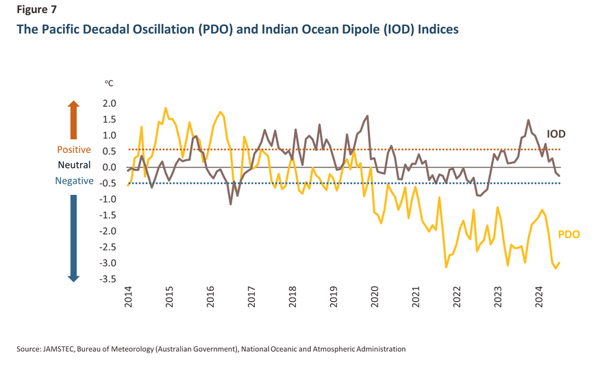
As Thailand’s rainy season progresses through the second half of 2024, there is a growing risk that extensive flooding will affect parts of the country. Indicators pointing in this direction include: (i) the weakening ONI, which is expected to swing from currently neutral conditions to a La Niña, thereby likely pushing rainfall above normal; (ii) the impact of regular tropical storms; (iii) the fall in the PDO and IOD indices, which are in or moving to a negative phase (i.e., below -0.5), indicating that Thailand is likely to be more exposed to storm conditions; and (iv) the fact that the monsoon index, which reflects short-term weather conditions, is close to normal, thus adding to the likelihood that areas around Thailand will continue to receive their seasonal rains. Krungsri Research expects that the northern, central and northeastern regions together with parts of the South will be the most heavily impacted parts of the country, though flooding will be a particular danger in the lower parts of the North and across the central regions; in the former case, this area acts as a channel funneling rains towards the sea, while the latter is essentially a large flood plain that is routinely exposed to widespread inundation. This will then have the potential to generate significant economic impacts on households, factory, machinery, crops, infrastructure and utilities. Krungsri Research expects that in the baseline scenario, flooding will affect 8.6 million rai in 2024, leading to property and asset losses of THB 3.1 billion and agricultural output losses of THB 43.4 billion. Consequently, total losses could reach THB 46.5 billion, reducing annual GDP by 0.27%.
Flood risks through the last 4 months of 2024
Across the first half of 2024, the tail end of the earlier El Niño left Thailand with hotter, drier weather that then undercut agricultural outputs, especially for field crops such as off-season rice, cassava and sugarcane. The resulting supply shortages meant that in some industries, companies were unable to deliver orders, while rising prices also had knock-on effects on the overall economy.
The weakening El Niño then transitioned to neutral conditions, though with enough momentum to carry the climate rapidly towards a La Niña, which may then trigger flooding across large parts of the country. Several climate indicators support this analysis.
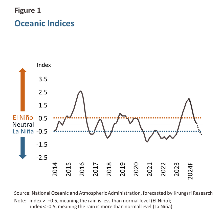
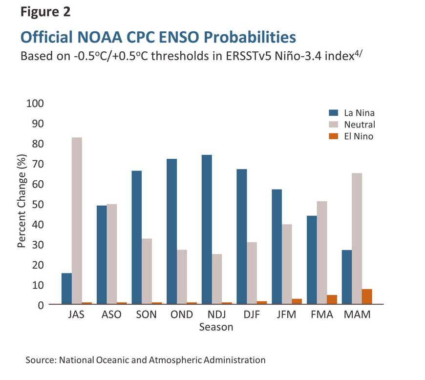
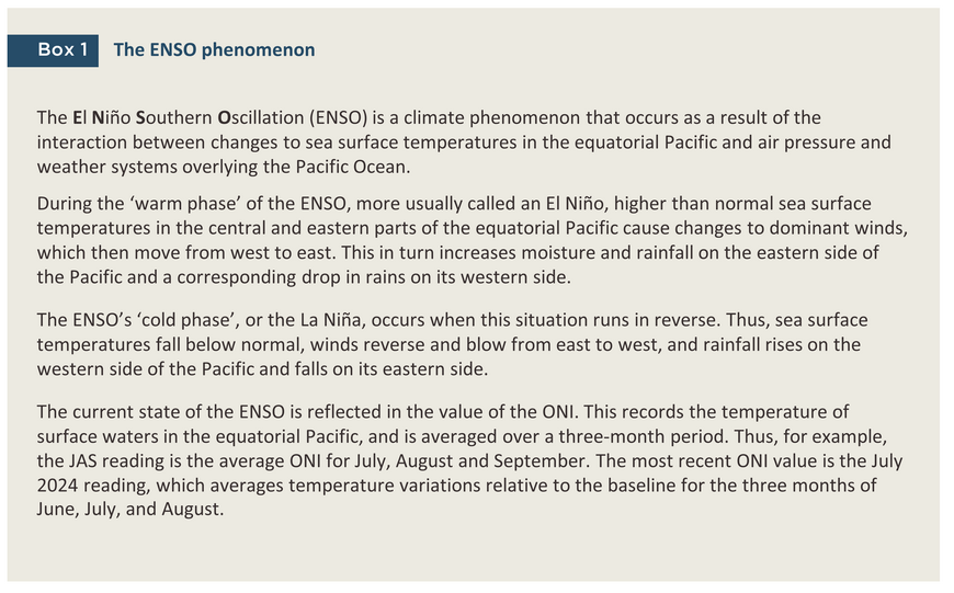
1) The Oceanic Niño Index (ONI) is based on sea surface temperatures in the equatorial Pacific that are then used to indicate the likelihood of El Niño/La Niña conditions emerging. As of July 2024, the ONI stood at 0.1, in the center of the neutral zone1/ (Figure 1) but the index has been weakening since the start of the year, and there is a growing chance that La Niña conditions will emerge2/. This is now expected to happen in October (Figure 2), and as ocean temperatures dip below their normal range, the chance that rainfall will be heavier than normal will rise correspondingly3/.
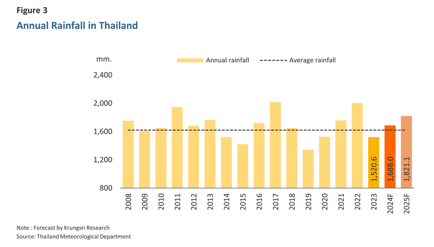
2) Rainfall is expected to rise 15.0-16.0% above average through July to December 20245/, and so from the middle of the year onwards, there has been an increased risk of flash flooding, particularly in flood plains and other flood-prone areas. However, as a result of the weakening El Niño, rainfall was below normal in the first half of 2024 and so for the year as a whole, average rainfall is expected to come to 1,688 mm, only very slightly above the 30-year average6/. 2024 rainfall is also some way off the 2011 total of 1,948 mm, which was a full 20.0% above normal (Figure 3).
In light of this, although heavy rainfall through the latter half of 2024 is adding to the risk of flooding, the strong EL Niño in the first half of the year meant that rainfall was down by -17.1% and so the ground was dry and ready to absorb large quantities of water. The current situation therefore differs markedly from 2011, which had higher water levels and soil moisture accumulation since the beginning of the year.

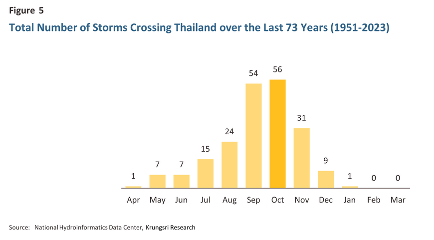
3) Number of cyclones, data gathered over the past 73 years show that on average, Thailand is affected by 2-3 tropical cyclones (i.e., tropical depressions and typhoons) each year, though over the past decade, this has fallen to more like 1 or 2 storms annually. Krungsri Research expects that Thailand will face 1-2 tropical cyclones entering the country, which is fewer than the 5 storms that hit Thailand during the major floods of 2011. The north and northeast of Thailand are closest to the normal storm tracks and the peak time for storms is September and October, when the rains are usually at the most intense (Figure 5), and so during this period, these regions are likely to experience flash flooding and rivers breaching their banks (Figure 6).
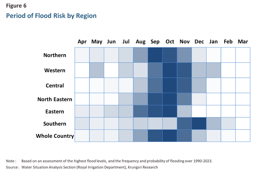
4) The impact of storms and the monsoon, in addition to major storms directly entering the country, Thailand also faces risks from the influence of storms and monsoons. Even if these do not directly hit Thailand, they may move into neighboring countries and later dissipate or change direction, still affecting rainfall levels in Thailand. This will particularly affect the east and northeast of Thailand through the second half of the year, when these areas will see rainfall rise as a result of storms, warm water currents, and monsoon conditions blowing in from the Pacific. These risks are reflected in the Pacific Decadal Oscillation Index (PDO)7/ and the Western Pacific Monsoon Index, which are negative and falling, indicating that rainfall is likely to rise. At the same time, areas in the west of Thailand will be impacted by the storms, warmer currents, and monsoon rains connected with the Indian Ocean, and as with the Pacific, the Indian Ocean Dipole Index (IOD)8/ and Indian Monsoon Index are negative with a downward trend further.
5) Water levels in large and mid-sized reservoirs are currently above average. As of the end of August, the country’s large reservoirs held a total of 44.62 billion m3 of water, or 62.9% of capacity. This is above the average for the past 14 years9/ but below the 53.19 billion m3 (76.4% of capacity) stored in 2011 during the year of the Great Flood (Figure 8). Similarly, 2.82 billion m3 is currently held in mid-sized reservoirs. This represents 55.4% of capacity and is higher than the average over the past 6 years10/.
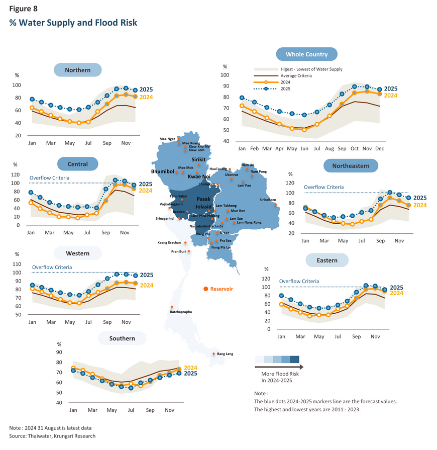
Given the influence of the factors described above, rainfall will likely trend above normal through the second half of the year, and coupled with the intensification in the rainy season, what was already slightly above normal levels of water in reservoirs can be expected to rise further and to approach historic highs11/. Through the middle of the rainy season in July and August, rainfall increased in all parts of the country, and so the risk of flooding is intensifying. It remains to be seen how the situation will develop as the rainy season intensifies in September and October, but with rainfall already set to strengthen, it will be important to track the situation closely.
Areas in the northern, northeastern, and central regions together with parts of the South are thus now at high risk of flooding. The lower north will be especially exposed to risk, since this region channels water from higher to lower parts of the country, as will the central region, which receives flood waters from the north and so has been subject to repeated flooding. Should widespread inundation occur, this will naturally generate losses for the agricultural sector, which is already suffering from the impacts on agriculture outputs of drought at the start of the year, though losses will extend beyond agricultural areas to include damage to buildings, homes, consumer goods, transportation routes and utilities.
2024 flooding to date
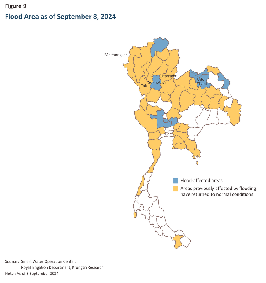
Over January to June, Thailand was affected by monsoon and low-pressure conditions in neighboring countries that then caused flooding, especially in central and northern regions12/. From the start of the year through to 8 September13/, 50 provinces experienced some degree of flooding, though as of 8 September 2024, the situation had returned to normal in 40 of these, and so flood conditions only persisted in 10 provinces14/ (Figure 9). Nevertheless, over the 30-day period from 9 August to 7 September15/ , 1.4 million rai experienced flooding and this impacted 0.18 million households. The most seriously hit provinces have been Chiang Rai (0.27 million rai), Sukhothai (0.20 million rai), Nakhon Phanom (0.15 million rai), Phayao (0.14 million rai) and Phichit (0.12 million rai). Likewise, the crops suffering the most widespread damage have been rice (0.31 million rai), corn (4,280 rai), sugarcane (935 rai) and cassava (654 rai).
Flood risks for the remainder of 2024
As previously mentioned, the risk of flooding in 2024 is expected to continue rising, particularly in September and October, affecting all regions except the South. For the Southern region, the risk is higher in November and December, due to the influence of monsoon troughs and tropical cyclones, which regularly pass through Thailand each year16/. Taking into account factors related to weather conditions and other environmental signals pointing to a high risk of flooding, Krungsri Research has produced a flood risk assessment based on the following assumptions.
Storms: The country will be hit by at least 1 or 2 tropical storms, and because La Niña conditions are expected to emerge in September, these will bring with them a greater than average volume of rain.
Rainfall: The onset of a La Niña will imply higher than average rainfall over the remaining 4 months of 2024, with forecast losses escalating in proportion to the volume of rainfall.
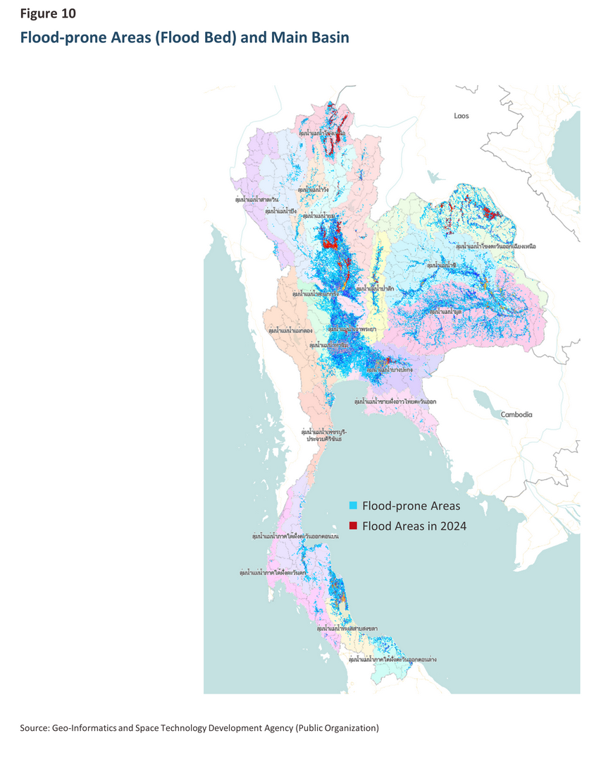
Areas affected: Although both large and mid-sized reservoirs had more than 40% spare capacity as of the end of August 2024, if rains fall outside the catchment areas for these, this will add to losses. This is a particular risk in the central region if rains fall south of the reservoirs or outside the 13 low-lying areas in the lower Chao Phraya river basin that are regularly flooded or that serve as flood abatement zones17/ (Figure 10).
Water levels in the main waterways: This will naturally be influenced by the volume of water flowing through watersheds, but if this exceeds the capacity of these rivers, there will clearly be a risk that riverbanks will be breached, and nearby areas flooded (Figure 10).
Additionally, there are several uncontrollable and unforeseen factors that may further increase the risk of flooding in 2024. For example, high tides in the Gulf of Thailand or high-water levels in aquifers and other natural sources of water, especially in the Mekong River basin, will slow the discharge of water to the sea, increasing the risk of flooding and adding to its extent if it does occur. However, the government can also help to alleviate overall levels of risk by anticipating problems, for example by preparing low-lying areas that can accommodate excess water, better managing reservoir levels, clearing waterways and increasing their throughput, moving machinery to areas likely to be flooded in advance of floodwaters, improving overall levels of water resource management, and checking and reinforcing dams, embankments, levies, public utilities and infrastructure generally.
Is flooding really better than drought? The current economic impacts of flooding and the outlook for the rest of 2024.
The consequences of flooding can be much more varied than for drought, since this can include damage to livestock, homes, factories and other structures, machinery, vehicles, and transportation routes. However, the impact on agricultural crops may vary, and if flood waters rise only slowly and recede rapidly, some crops may be entirely unharmed, but if flood waters are fast moving and standing bodies of water take an extended period of time to drain away, the extent of losses to crops such as rice, sugarcane, cassava and vegetables and other agricultural produce can be extremely significant. Moreover, this will then have downstream impacts and as supply chains tighten, industries that are reliant on agricultural inputs will face shortages, while limited supply will almost inevitably feed through into higher prices.
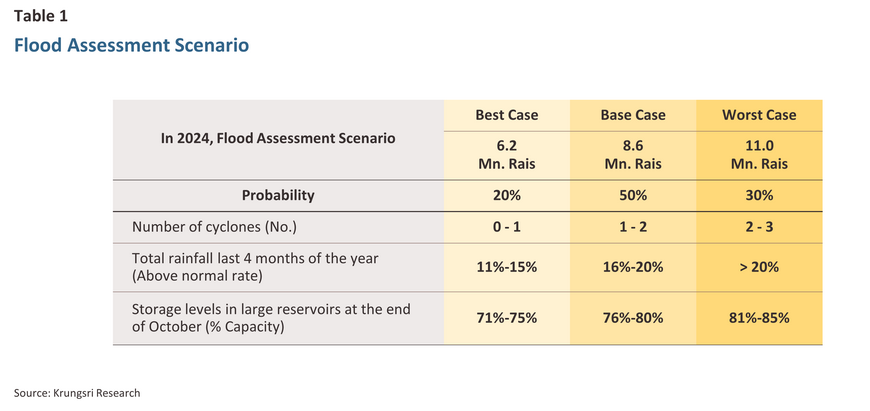
To provide insight into the likely scale of these problems, Krungsri Research has assessed the expected extent of 2024 flood impacts in terms of the area of agricultural land impacted by flooding and the economic consequences of this. Three scenarios have been modeled, each reflecting steadily worsening outcomes18/ (Table 2).
Best case: In the low-impact scenario, 6.2 million rai are affected by flooding, resulting in property and asset losses worth THB 2.2 billion, along with an additional THB 31.2 billion in crop losses. The total losses amount to THB 33.4 billion, or -0.19% of GDP.
Base case: In this scenario, 8.6 million rai are inundated, resulting in property losses of THB 3.1 billion and crop losses of THB 43.4 billion. The total losses amount to THB 46.5 billion, or -0.27% of GDP.
Worst case: In the high-impact scenario, 11.0 million rai of land are flooded, resulting in property losses of THB 4.0 billion and crop losses of THB 55.5 billion. With total losses amounting to THB 59.5 billion, the worst-case flooding would reduce annual GDP by -0.34%.
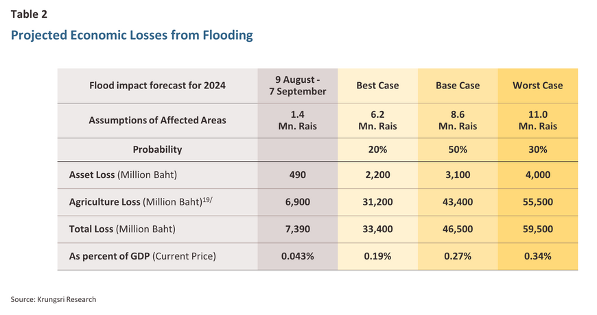
The level of flood damage to the economy depends on: 1) rainfall and water management, 2) the affected area, and 3) the location of economic units (households, factories, agricultural areas). Given this, if flooding occurs in economically significant areas, the resulting impacts will be correspondingly more severe, so for example, if locations that are home to industrial estates, major agricultural operations, or important transportation routes are damaged, this is much more likely to trigger impacts across the length of supply chains, from upstream production through to downstream distribution and on to the economy more broadly.
However, Krungsri Research expects that the floods in the second half of 2024 will not be as severe as the great floods of 2011, nor will they impact the economy to the same extent. The World Bank estimated the damage from the 2011 floods at as much as THB 1.44 trillion20/ as it is anticipated that in 2024, there will be less rainfall and more water storage capacity, both from large and medium-sized dams. Additionally, the improved water management capabilities of the government (e.g., warning systems, maintenance, budget support) and enhanced private sector flood protection measures, particularly in industrial estates, will contribute to more effectively mitigating the impact.
1/ The ONI is considered to be ‘neutral’ when sea surface temperatures in equatorial regions of the Pacific are in a range of -0.5 °C and +0.5 °C of their average.
2/ The La Niña is a phenomenon witnessed when sea surface temperatures in parts of the Pacific fall below the average, which usually leads to changes in the distribution of atmospheric moisture and higher than normal rainfall in Southeast Asia. The intensity of these events is measured by the ONI Index, with values of -0.5 °C to -0.9 °C considered a weak La Niña. Values of -1.0 °C to -1.4 °C are classified as a moderate La Niña, between -1.5 °C and -2.0 °C is a strong La Niña, and anything over -2.0 °C qualifies as a very strong La Niña. If the ONI is positive and above 0.5 °C, this points to El Niño conditions, which are graded similarly to those for La Niña, though with positive rather than negative deviations from average temperatures.
3/ Average refers to the 30-year mean for 1991-2020.
4/ In particular, the area of importance lies between 5 oN and 5 oS and between 170 oW and 120 oW. This is referred to as the Nino 3.4 Region.
5/ This refers to the 30-year average for 1991-2020.
6/ Over the past 30 years, annual rainfall has averaged 1,623 mm.
7/ The Pacific Decadal Oscillation (PDO) is a phenomenon caused by differences in sea temperatures on either side of the Pacific in the region 20 oN. During a negative phase, water in the east is warmer, and this tends to raise rainfall in Thailand and nearby areas above normal levels, with positive and negative phases typically cycling over a period of around 30 years. As of July 2024, the PDO had a value of -3.0.
8/ The Indian Ocean Dipole (IOD) (or the Dipole Mode Index (DMI)) measures the oscillation in local water temperatures between the east and west sides of the Indian Ocean in the areas 50 oE-70 oE, 10 oS-10 oN and 90 oE-110 oE, 10 oS-0 oN. When the index is in a negative phase, warm water collects in the east of the Indian Ocean, and this is linked to an increase in rainfall in Thailand and neighboring countries. In July 2024, the IOD stood at -0.3.
9/ Available data covers the 14 years from 2011 to 2024. Through this period, average water levels in large reservoirs at the end of August were at 59.3% of capacity.
10/ The data that is available covers the 6 years from 2019 to 2024. Through this period, average water levels in mid-sized reservoirs at the end of August stood at 53.6% of capacity.
11/ That is, the highest level reported in monthly data over the period 2011-2023 (the upper edges of the gray bands on the graphs showing regional reservoir levels in Figure 8).
12/ Information from the National Agricultural Big Data Center shows that losses valued at THB 100.5 million have occurred on 8,600 rai in the 7 provinces of Kamphaeng Phet, Uthai Thani, Phayao, Tak, Uttaradit, Suphanburi and Kanchanaburi.
13/ Source: Data on current rain water management published by the Bureau of Water Management and Hydrology, 8 September, 2024.
14/ Chiang Rai, Sukhothai, Chainat, Suphanburi, Ang Thong, Saraburi, Ayutthaya, Nong Khai, Udon Thani, and Nakhon Phanom are still affected by flooding.
15/ These losses are based on estimates and have not yet been verified through on-site assessments. Source: Geo-Informatics and Space Technology Development Agency.
16/ Source: Three-month weather forecast for Thailand for September to November, 2024, issued 26 August, 2024.
17/ Areas that have been repeatedly flooded over the 9 years between 2011 and 2020 or that serve as flood abatement areas include: Thung Chiang Rak, Thung Fang Sai Khlong Chai Nat-Pa Sak, Thung Tha Wung, and Thung Bang Kum, which receive water from Khlong Chai Nat-Pa Sak; Thung Pa Mok, Thung Phak Hai, and Thung Jao Jet, which receive water from Noi River; Thung Bang Kung, and Thung Bang Bal, which receive water drawn from Chao Phraya River; Thung Pho Phraya, which receives water from Tha Chin River; and Thung Phraya Banlue, Thung Phra Phimon, and Thung Rangsit Tai, which receive water drawn from canals in the local area.
18/ Forecasts are derived from the area of land currently affected by flooding and the likelihood of floods occurring in additional areas through the remainder of 2024. This is based on an assessment of historical data collected by the National Hydroinformatics Data Center, the Office of Agricultural Economics, the Office of the National Economic and Social Development Council, the Geo-Informatics and Space Technology Development Agency, the Department of Disaster Prevention and Mitigation, the Royal Irrigation Department, and the National Agricultural Big Data Center.
19/ Calculated by Krungsri Research based on data on affected land as of 30 August, 2024 and the assumption that losses occur on 60-70% of all agricultural land impacted by flooding. Loss value = ( production losses = Total area of completely damaged agricultural land x Yield per rai ) x Average agricultural product price in 2024.
20/ Source: 04 Thailand’s National Adaptation Plan, The Institute for Sustainable Development of Natural Resources and Environment (mnre.go.th).
Department of Disaster Prevention and Mitigation (DDPM) of the Ministry of Interior
Established under the Ministry of Interior as the prime agency for coordinating disaster risk management activities by all related organizations at all levels.
Department of Disaster Prevention and Mitigation(DDPM)


DDPM Background

DDPM was established on the 3rd of October 2002 as an agency under Ministry of Interior (MOI) to handle disaster management responsibilities. As disaster situations in Thailand got worse due to population increase, urbanization and impact of climate change, the establishment of DDPM is to have a better and more effective mechanism to prevent disaster damage and loss and to mitigate calamity due to man-made and natural disasters.
Director

Mr.Teerapat Kutchamath
(Director – General Department of Disaster Prevention and Mitigation)
Organizational structure


.png)


 | |
 | Formulate policy, guideline and measures on disaster prevention and mitigation; |
| Study, analyse, research and develop systems on disaster prevention, disaster warning and disaster mitigation; |
| Develop information technology on disaster prevention and mitigation; |
| Promote people participation on disaster managment activites; |
| Build disaster risk awareness; |
| Provide training to build capacity and improve skills on disaster management and disaster relief; |
| Promote, support and implement programs for assisting disaster victims and disaster recovery; |
| Direct and coordinate operation to assist disaster victims in large-scale disasters; and |
| Coordinate with domestic and international agencies/organizations; |
Thailand’s population of nearly 70 million to be protected by new early warning and hazard monitoring technologies
Source(s): Pacific Disaster CenterUpload your content

aphotostory/Shutterstock
Thailand operates a Multi-Hazard Early Warning System (MHEWS) designed to detect, monitor, and disseminate alerts for a wide range of hazards—including floods, tropical cyclones, tsunamis, landslides, drought, and extreme weather. The system integrates data from meteorological, hydrological, geological, and ocean monitoring networks and is coordinated mainly by the Thai Meteorological Department (TMD), the Department of Disaster Prevention and Mitigation (DDPM), and partner agencies.
It provides real-time warnings through sirens, SMS, radio, television, mobile apps, and community-based channels, enabling rapid communication to at-risk populations. Thailand’s system emphasizes risk assessment, community preparedness, and multi-agency coordination, following international standards and lessons learned from major disasters such as the 2004 Indian Ocean tsunami.
The national government of Thailand and Pacific Disaster Center (PDC) have just operationalized a new early warning and hazard monitoring system called ThaiAWARE. The system will provide advanced decision support capabilities to the country’s disaster managers and help protect its 70 million residents and millions of visitors who make Thailand a vacation destination each year.
“Early warning is a really important function and one that has been proven to save lives and reduce loss from disasters,” said Regional Advisor Harlan Hale of USAID’s Bureau for Humanitarian Assistance. “Unfortunately, from the impacts of climate change, especially in this region, we can expect more disaster events and perhaps more severe disaster events.” USAID provided critical funding support for the ThaiAWARE project throughout recent years. The ThaiAWARE supplies decision makers with real-time, dynamic information from both international and national sources and offers the world’s most advanced multi-hazard exposure modeling capabilities in a single platform. This comprehensive system for Thailand’s disaster managers enables them to jump into action which means a faster response. A faster response means a better response with fewer impacts and a speedier recovery.
“I believe the ThaiAWARE system will become an important tool in making Thailand resilient,” said Thailand’s Department of Disaster Prevention and Mitigation (DDPM) Director General Boontham Lertsukekasem, who expressed his appreciation for the USAID-funded project and highlighted its importance in enhancing early warning for Thailand. “We would like to express our sincere gratitude to USAID and PDC once again for your support.”
DDPM and PDC—a University of Hawaii Applied Science and Technology Center—celebrated the launch of the new ThaiAWARE system during a virtual ceremony on Dec. 15 marking the completion of the project. Various government and nongovernmental stakeholders attended, including representatives from DDPM, the National Disaster Warning Center (NDWC), the ASEAN Coordinating Centre for Humanitarian Assistance (AHA Centre), USAID and more.
It was during the aftermath of the devastating M9.0 Indian Ocean earthquake and tsunami of 2004 that the government of Thailand first partnered with PDC. “PDC was at ground zero during the formation of Thailand’s NDWC and we helped implement the nation’s first early warning system in partnership with the DDPM in 2006,” said PDC Deputy Executive Director Chris Chiesa. The initial system, now branded ThaiAWARE, was PDC’s first customized, remote deployment of DisasterAWARE in Asia, and only the second world-wide. “The system we just launched with the government of Thailand includes the new early warning and multi-hazard monitoring technologies offered in DisasterAWARE, as well as critical predictive hazard impact analysis tools and hundreds of new national data layers to support effective preparedness and response,” Chiesa added.
Chiesa explained that this is another important milestone in a longstanding partnership of more than 15 years, for which he anticipates exciting new developments in the coming year. He shared details of a pending U.S. Trade and Development Agency (USTDA)-funded program that will leverage the ThaiAWARE system for public alerting.
“It will allow mass notification,” Chiesa said of the project planned for early 2022. “It will allow residents and visitors of Thailand to receive disaster notifications for tsunamis, floods, wildfires, COVID outbreaks. We’re extremely hopeful that we get this project started very soon.”