An appeal to the Director of the Myanmar Disaster Preparedness Agency (MDPA)
To,
The Director General, Myanmar Disaster Preparedness Agency (MDPA)
Subject: Proposal for Technical Cooperation and Partnership to Strengthen Multi-Hazard Early Warning Systems, Disaster Risk Governance, and Emergency Management Capacities of the Myanmar Disaster Preparedness Agency (MDPA)
Dear Sir,
Greetings from the Multi-Hazard Early Warning System Development and Implementation Center (MHEWC).
MHEWC is a specialized technical knowledge and solutions platform dedicated to strengthening climate and multi-hazard risk governance, disaster risk management, and the design and operationalization of integrated, end-to-end, people-centered early warning systems. Our technical expertise encompasses institutional capacity assessments, hydro-meteorological observation and monitoring networks, geospatial risk intelligence, ICT- and AI-enabled Decision Support Systems (DSS), impact-based forecasting, anticipatory action, and disaster preparedness, response, and recovery management.
Recognizing the critical importance of strengthening the national disaster risk management capabilities, MHEWC would welcome the opportunity to establish technical cooperation and a strategic working partnership with the MDPA.
In collaboration with MDPA, relevant national hydro-meteorological institutions, sectoral ministries, local authorities, and other stakeholders, MHEWC is prepared to provide specialized technical assistance in the following priority areas:
1) Assessment and Modernization of Hydro-Meteorological Observation and Monitoring Networks
Conduct comprehensive technical diagnostics of existing hydro-meteorological observation stations and monitoring infrastructure, identify institutional and technological gaps, and develop a phased modernization and investment plan. This may include the technical design, installation, calibration, and integration of Automated Weather Stations (AWS), Internet of Things (IoT) sensors, and real-time environmental and hazard-monitoring technologies to strengthen the detection, tracking, and forecasting of potentially hazardous conditions.
2) Strengthening Integrated Multi-Hazard Monitoring and Early Warning Capacities
Assess existing monitoring, observation, forecasting, and early warning capabilities and support MDPA and relevant national meteorological and hydrological services in upgrading and integrating observation networks. This includes hybrid weather and hazard-monitoring systems, interoperable sensor networks, real-time data acquisition and transmission, and automated data ingestion into operational Decision Support Systems for multi-hazard monitoring, forecasting, and warning dissemination.
3) Modernization and Operationalization of the National Emergency Operations Center (EOC)
Undertake a comprehensive technical and institutional assessment of existing Emergency Operations Center facilities, operational procedures, communication systems, and information management infrastructure. Based on the findings, develop an EOC modernization roadmap and support the technical design, upgrading, and operationalization of an integrated National Emergency Operations Center and Situation Room.
The proposed EOC architecture would incorporate real-time hydro-meteorological observations, IoT-enabled monitoring networks, geospatial risk information, automated hazard tracking, impact-based forecasting, early warning dissemination, anticipatory action advisories, and coordinated emergency response management.
4) Development of ICT- and AI-Enabled Emergency Management and Decision Support Applications
Design and develop customized ICT- and AI-enabled applications to support automated hazard identification, real-time monitoring, predictive analytics, impact forecasting, emergency information management, and operational decision-making.
These solutions may include automated data processing, geospatial visualization, scenario-based impact analysis, threshold-based alert generation, emergency resource tracking, incident management, and decision-support workflows. AI-assisted outputs would be subject to appropriate technical validation and oversight by authorized national institutions.
5) Transformation of MDPA’s Web Portal into an Integrated Geospatial Decision Support Platform
Provide technical assistance to assess and upgrade MDPA’s existing web-based information systems into an integrated, geospatial, database-driven, and application-enabled Disaster Risk Information and Decision Support System (DRI-DSS).
The platform would support real-time hazard monitoring, climate and multi-hazard risk information management, institutional coordination, preparedness planning, anticipatory action, emergency response, recovery management, and evidence-based decision-making across national and subnational administrative levels.
6) Development of National Climate and Multi-Hazard Risk Assessment Frameworks and Risk Information Repositories
Develop standardized methodologies, analytical frameworks, technical tools, and operational guidelines for conducting climate and multi-hazard risk and vulnerability assessments.
Technical assistance would include the preparation of GIS-based hazard, exposure, vulnerability, and risk maps; multi-sectoral risk profiles; climate and disaster risk scenarios; and the establishment of a centralized, interoperable national risk information repository and geospatial database management system.
7) Design and Operationalization of End-to-End, People-Centered Multi-Hazard Early Warning Systems
Support MDPA and relevant technical institutions in designing and implementing integrated, end-to-end Multi-Hazard Early Warning Systems (MHEWS), aligned with the four pillars of the Early Warnings for All (EW4All) initiative.
Priority interventions may include:
- Hazard detection, monitoring, weather nowcasting, and forecasting services.
- Impact-Based Forecasting (IBF) and Impact-Based Warning (IBW) systems.
- Forecast-Based Financing (FbF) and anticipatory action mechanisms.
- Development of hazard-specific triggers, Early Action Protocols (EAPs), and anticipatory response plans.
- Common Alerting Protocol (CAP)-enabled warning generation and dissemination.
- DSS-supported emergency preparedness, contingency planning, and response management.
- Development of operational guidelines, Standing Orders on Disaster, and institutional Standard Operating Procedures (SOPs).
- Strengthening last-mile warning communication, community preparedness, and coordinated early action.\
8) Integration of Climate and Disaster Risk Intelligence into Sectoral and Local Development Planning
Develop GIS-enabled databases, digital planning tools, and sector-specific risk information systems to support national ministries, government departments, municipalities, and local authorities in integrating climate and disaster risk considerations into development planning, public investment, and budgeting processes.
Technical assistance would focus on strengthening Disaster Risk Reduction (DRR), Climate Change Adaptation (CCA), Nature-Based Solutions (NbS), Locally Led Adaptation (LLA), resilient infrastructure planning, and climate-informed sectoral investment strategies.
9) Review and Strengthening of Multi-Hazard Preparedness, Emergency Response, and Recovery Plans
Review existing disaster preparedness, emergency response, contingency, and recovery plans at national, regional, municipal, and sectoral levels.
Support the development and upgrading of hazard-specific and multi-hazard operational plans, institutional coordination mechanisms, emergency communication protocols, resource mobilization procedures, and risk-informed recovery strategies consistent with MDPA ’s mandate and national disaster management priorities.
10) Strengthening National-to-Local Disaster Risk Governance and Institutional Capacities
Provide specialized technical assistance to strengthen the institutional, regulatory, organizational, and operational foundations of disaster risk governance.
This may include institutional assessments, capacity development, stakeholder coordination frameworks, interagency information-sharing protocols, technical training, knowledge transfer, and the preparation of phased, costed implementation roadmaps to improve national and local emergency management capabilities.
11) Technical Support to Climate Change, Meteorological, Hydrological, and Disaster Management Institutions
Provide targeted technical support to MDPA, relevant climate change institutions, National Meteorological and Hydrological Services (NMHS), and other designated government agencies to strengthen climate information services, weather and climate monitoring, multi-hazard risk assessments, forecasting, early warning operations, climate resilience planning, and institutional technical capacities.
Such cooperation would be tailored to institutional requirements, existing technical infrastructure, priority hazards, and national development objectives.
Proposed Way Forward
MHEWC proposes initiating the cooperation through a joint technical consultation with MDPA to identify priority institutional and technological needs, review existing capacities, and determine potential areas for collaboration.
Based on MDPA’s priorities, we would welcome the opportunity to conduct an initial technical scoping and institutional capacity assessment, followed by preparing a practical, phased, costed technical cooperation and implementation roadmap.
Our approach emphasizes national ownership, technology transfer, institutional sustainability, interoperability, and the development of operational systems that connect hazard observation and risk intelligence with timely warnings, informed decisions, and effective anticipatory action.
We would be pleased to arrange a virtual meeting with your technical and management teams at a mutually convenient time to discuss potential collaboration and identify immediate opportunities for technical support.
We look forward to your favorable consideration and the opportunity to contribute to strengthening national disaster risk governance, multi-hazard early warning, and emergency management systems.
Yours sincerely,
Z M Sajjadul Islam
Director & Advisor
Multi-Hazard Early Warning System Development and Implementation Center (MHEWC)
Website: https://www.mhewc.org/cambodia/ http://www.glocs.org
Email: zmsajjad@gmail.com | sajjad@mhewc.org
Phone & WhatsApp: +88 01711 979179
Climate risk and vulnerabilities of Myanmar
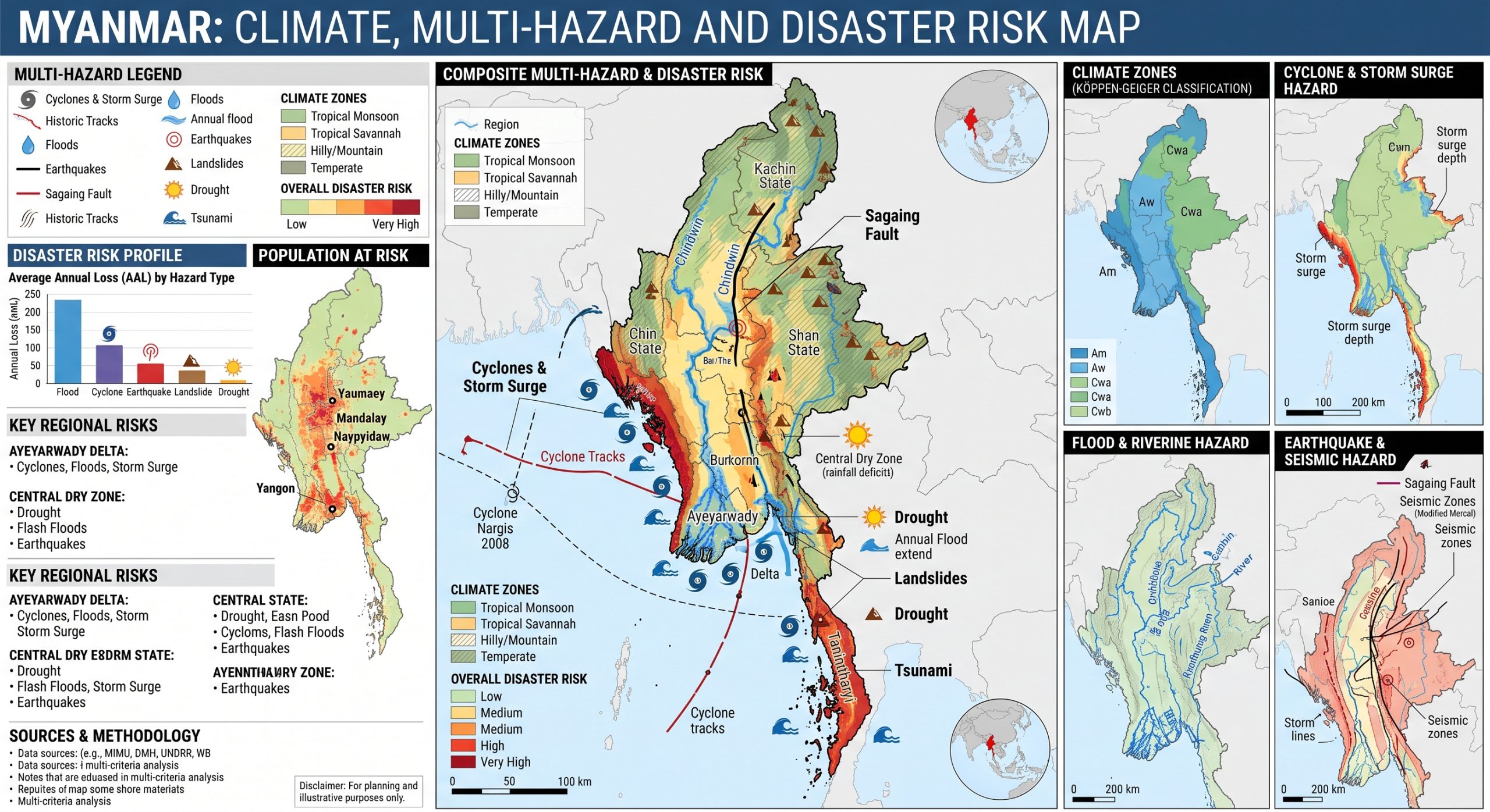

Myanmar is highly vulnerable to climate change and multi-hazard risks due to its exposure to cyclones, storm surges, floods, landslides, droughts, extreme heat, earthquakes, tsunamis, coastal erosion, salinity intrusion, and forest fires. The country’s long Bay of Bengal coastline, low-lying Ayeyarwady Delta, major river basins, mountainous terrain, monsoon rainfall, climate-sensitive agriculture and fisheries, and fragile infrastructure create a complex risk environment. Climate change is intensifying these vulnerabilities through rising temperatures, erratic rainfall, more extreme precipitation, increasing flood and storm impacts, drought stress, sea-level rise, and water and food-security pressures. Vulnerability is further compounded by conflict, displacement, poverty, weakened institutions, limited humanitarian access, and high dependence on natural-resource-based livelihoods. Strengthening multi-hazard early warning systems, cyclone and flood preparedness, climate-resilient agriculture, water security, coastal protection, resilient infrastructure, disaster risk financing, and inclusive community-based preparedness is essential to reduce losses and protect vulnerable communities. Myanmar is highly vulnerable to multi-hazard risks due to its long Bay of Bengal coastline, low-lying Ayeyarwady Delta, major river basins, mountainous and landslide-prone terrain, monsoon climate, exposure to tropical cyclones, active seismic setting, high rural dependence on agriculture and fisheries, and the compounding effects of conflict, displacement, poverty, and weakened service delivery.

1. Multi-hazard exposure
Myanmar faces one of the most complex hazard profiles in Southeast Asia. The country is exposed to earthquakes, floods, strong winds, cyclones, storm surges, periodic droughts, fires, tsunamis, and industrial or technological hazards. The 2023 Humanitarian Needs Overview reported that Myanmar ranked very high globally for exposure to natural hazards, particularly floods, earthquakes, and tsunamis.
Cyclones and floods are among the most severe recurring hazards. Myanmar’s coastline is exposed to tropical cyclones forming in the Bay of Bengal, and major cyclone events have included Cyclone Nargis in 2008, Cyclone Mocha in 2023, and the flood and landslide impacts associated with Typhoon Yagi in 2024. The World Bank notes that damaging tropical cyclone occurrence has shown an increasing trend in recent decades, with impacts caused by high winds, storm surge, floods, and associated landslides. (World Bank)
2. Climate change as a risk multiplier
Climate change is increasing Myanmar’s exposure to rapid-onset and slow-onset hazards. The Red Cross Red Crescent Climate Centre reports that Myanmar faces high disaster risk and is exposed to riverine, urban and coastal flooding, tropical cyclones, landslides, heatwaves, and droughts; it also notes that mean annual temperature increased by about 0.2°C per decade during 1961–2015.
Myanmar’s Climate Change Strategy states that observed and projected climate impacts are heightening the risks of rapid-onset disasters such as floods and cyclones, while also driving slower changes including erratic rainfall, higher temperatures, reduced agricultural productivity in the Central Dry Zone, sea-level rise, and soil salinization.
3. Cyclone, storm surge, and coastal vulnerability
Myanmar’s coastal regions, especially Rakhine State, Ayeyarwady Region, Yangon Region, Mon State, and Tanintharyi Region, are highly vulnerable to cyclones, storm surge, coastal flooding, erosion, and saltwater intrusion. The Ayeyarwady Delta is particularly exposed because of its low elevation, dense rural settlements, rice production, fisheries, river channels, and proximity to the Bay of Bengal.
Cyclone Nargis remains the most devastating example of Myanmar’s cyclone risk. The World Bank’s 2025 flood assessment notes that Nargis caused up to 146,000 deaths in the low-lying Irrawaddy/Ayeyarwady Delta and generated very large economic damages and losses. (World Bank) This demonstrates the importance of cyclone early warning, evacuation planning, resilient shelters, coastal embankments, mangrove restoration, and last-mile risk communication.
4. Flood and landslide vulnerability
Flooding is one of Myanmar’s most recurrent and damaging hazards. Flood risk is high along major river systems including the Ayeyarwady, Chindwin, Sittaung, Salween/Thanlwin, Bago, and Yangon river systems, as well as in urban areas with poor drainage. The Climate Centre notes that flooding frequently occurs during the rainy season from June to October, and that rainfall has become more intense and unpredictable, increasing flood risk.
The 2024 Typhoon Yagi-related floods show how severe this risk can become. The World Bank estimated that nearly 2.4 million people, more than 1 million structures, about 430,000 hectares of cropland, and around 2,200 km of road infrastructure were exposed to flooding caused by Typhoon Yagi in Myanmar. (World Bank) Reported impacts included more than 433 deaths, over 958,000 people affected, more than 320,000 people displaced, damaged roads and bridges, affected schools, damaged telecommunication towers, electricity disruption, and large areas of flooded cropland. (World Bank)
5. Drought, heat, and Central Dry Zone vulnerability
Drought and heat stress are major concerns, particularly in Myanmar’s Central Dry Zone, where rainfall variability, high temperatures, water scarcity, degraded soils, and dependence on rainfed farming increase vulnerability. Climate change is expected to worsen agricultural water stress, reduce crop yields, disrupt planting calendars, increase livestock stress, and affect rural livelihoods.
Drought also interacts with food insecurity, migration, water access, and health risks. Households with limited irrigation, savings, insurance, and livelihood diversification are especially vulnerable. Climate shocks in dry-zone areas can therefore become both food-security risks and poverty/debt risks.
6. Agriculture, fisheries, and livelihood vulnerability
Myanmar’s rural economy is highly climate-sensitive. Agriculture, fisheries, and livestock are central to livelihoods and food security, but they are exposed to floods, droughts, salinity intrusion, heat stress, pests, diseases, and cyclone damage. The Climate Centre notes that as much as 85% of rural livelihoods depend on climate-sensitive sectors, and that agriculture is a core sector employing a large share of the labour force.
Key agricultural vulnerabilities include:
| Sector | Main risks |
|---|---|
| Rice production | Floods, drought, salinity intrusion, storm damage, rainfall variability |
| Dry-zone farming | Drought, heat stress, poor soil moisture, crop failure |
| Livestock | Heat stress, water scarcity, disease, feed shortages |
| Fisheries | Cyclones, storm surge, changing river flows, coastal ecosystem degradation |
| Rural markets | Road disruption, crop losses, price shocks, reduced income |
| Smallholders | Limited access to credit, irrigation, insurance, climate information, and recovery support |
7. Water, WASH, and health vulnerability
Myanmar’s water systems are vulnerable to both drought and flood contamination. Flooding can damage wells, ponds, water systems, latrines, roads, and health facilities, while drought can reduce safe water availability and increase pressure on groundwater. Coastal areas also face increasing saltwater intrusion, which can make groundwater unsuitable for drinking and agriculture.
Climate change also increases public health risks. The Climate Centre notes that climate change is expected to increase risks from vector-borne and waterborne diseases, damage health infrastructure, and increase injury, loss of life, and mental-health challenges. Floods can increase cholera, typhoid, hepatitis A, and other waterborne disease risks, while heatwaves can increase heat-related illness and mortality.
8. Urban and infrastructure vulnerability
Urban areas such as Yangon, Mandalay, Nay Pyi Taw, Bago, Mawlamyine, and coastal towns face risks from urban flooding, poor drainage, river overflow, heat stress, cyclones, water contamination, and infrastructure disruption. Yangon is particularly vulnerable because of its low-lying deltaic setting, river confluences, urban growth, drainage congestion, and exposure to coastal and riverine flooding.
Critical infrastructure risks include:
| Infrastructure system | Main risks |
|---|---|
| Roads and bridges | Flood washouts, landslides, cyclone damage, access disruption |
| Schools and health facilities | Flooding, wind damage, earthquake exposure, service interruption |
| Water and sanitation systems | Flood contamination, drought stress, salinity intrusion |
| Electricity and telecoms | Wind damage, flood exposure, landslides, recovery delays |
| Ports and coastal assets | Storm surge, sea-level rise, erosion, cyclone damage |
| Irrigation and embankments | Flood overtopping, sedimentation, drought stress, poor maintenance |
9. Earthquake and tsunami vulnerability
Myanmar also faces significant geophysical risk. The country is exposed to seismic activity, including along major fault systems, and to tsunami risk along its coast. Earthquakes can damage buildings, roads, bridges, hospitals, schools, water networks, and power systems. Coastal earthquake and tsunami risk is particularly serious where warning coverage, evacuation routes, shelters, and public awareness are weak.
UNDRR emphasized in 2025 that Myanmar requires stronger support to understand climate and disaster risks and to strengthen early warning systems, including after earthquake impacts. (UNDRR)
10. Conflict-sensitive and social vulnerability
Myanmar’s disaster risk is strongly intensified by conflict, displacement, access constraints, poverty, and weakened institutions. Floods, cyclones, and earthquakes can affect areas where humanitarian access is already restricted, infrastructure is damaged, and communities have limited coping capacity. The World Bank’s 2025 analysis of Typhoon Yagi specifically notes that conflict and insecurity complicated disaster impacts, limited access to affected areas, and constrained humanitarian response and recovery. (World Bank)
The most vulnerable groups include internally displaced people, conflict-affected communities, smallholder farmers, landless rural workers, fishing communities, women-headed households, children, older persons, people with disabilities, ethnic minority communities, informal urban settlers, and people living in flood-prone, cyclone-prone, drought-prone, landslide-prone, coastal, or seismic areas.
11. Priority resilience needs
Myanmar’s resilience agenda should prioritize:
| Priority area | Key actions |
|---|---|
| Multi-hazard early warning systems | Strengthen cyclone, flood, landslide, drought, heat, earthquake, and tsunami warning; improve last-mile communication |
| Cyclone and coastal risk management | Shelters, evacuation routes, storm-surge mapping, embankments, mangrove restoration |
| Flood and landslide risk reduction | River-basin forecasting, slope-risk mapping, drainage upgrades, watershed management |
| Climate-smart agriculture | Drought-tolerant crops, flood-resilient rice, salinity management, crop advisories, index insurance |
| Water security and WASH | Safe water systems, groundwater monitoring, flood-safe sanitation, drought preparedness |
| Urban resilience | Risk-informed urban planning, drainage improvement, resilient housing, heat action planning |
| Infrastructure resilience | Climate- and seismic-resilient roads, bridges, schools, hospitals, and energy systems |
| Shock-responsive social protection | Scalable cash support, anticipatory action, livelihood recovery, support for displaced people |
| Disaster risk financing | Contingency finance, insurance mechanisms, emergency funds, recovery financing |
| Community-based preparedness | Local evacuation planning, inclusive risk communication, drills, local response capacity |
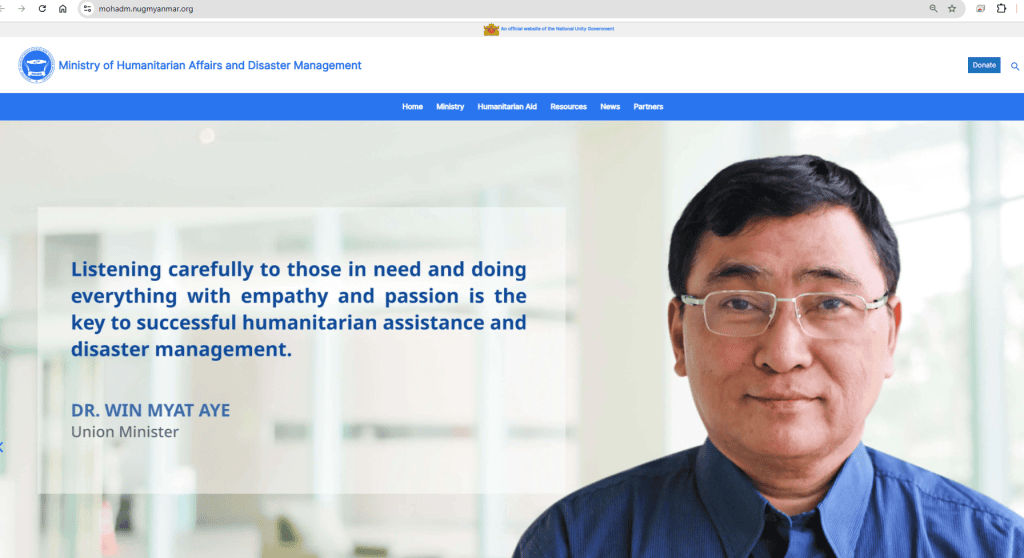
Myanmar Disaster Preparedness Agency (MDPA)


Department of Disaster Management (DDM)
Relief and Resettlement Department had emerged in Myanmar since the pre-independence .1945, a center for social and rehabilitation has emerged in the Office of the Director load desertion collecting loans and resettlement issues. 1948 When independence of Education, Ministry of Social and Rehabilitation was originally formed as operations proceed. Education on (1-11-1951) Relief and re-formed as the Ministry of placement loan collection, deserters Insurgency community housing forsaken supplies to rescue people, destroyed homes and placed back in service. (17-3-1952) Day, in collaboration with the Ministry of Minority Affairs in the Ministry of Relief and Resettlement, re-established as an IDP loans collection Relief aid and resettlement work. The emergence of social welfare activities, social welfare, 1953 Relief and re-formed as the Ministry of resettling 1957 Relief Re-positioning, and was reorganized as the Ministry of National Unity. In 1972, rescue, Resettlement and the Ministry of National Unity formed as canceled. Relief and Resettlement Department under the Ministry of Social Welfare Department. Relief and Resettlement Department, Emergency Management Center (EOC), Disaster Management Training Center (DMTC), Region / State Department’s Office (15) Office and the Office of the District Officer’s Office (29) activities. On 31.1.2018 the name of Relief and Resettlement Department, the Department of Disaster Management name was transformed.
Department of Rehabilitation
Department of Rehabilitation undertakes its tasks by underlining the rehabilitation programs on peace and ethnic affairs and abiding the policy of ministry which is bringing about the society that ensure enjoyment of human rights through providing rehabilitation programs for people with disabilities, ex-drug addicts, human trafficking, sex trafficking, child soldiers, abandoned children, child soldier, child rape survivors, children in conflict with the law, street children, pregnant women, older people, commercial sex workers, natural disasters and manmade disasters.Department of Rehabilitation undertakes its tasks by underlining the rehabilitation programs on peace and ethnic affairs and abiding the policy of ministry which is bringing about the society that ensure enjoyment of human rights through providing rehabilitation programs for people with disabilities, ex-drug addicts, human trafficking, sex trafficking, child soldiers, abandoned children, child soldier, child rape survivors, children in conflict with the law, street children, pregnant women, older pe
Useful Documents
An appeal to the Director of the Myanmar Disaster Preparedness Agency (MDPA)
To,
The Director General, Myanmar Disaster Preparedness Agency (MDPA)
Subject: Proposal for Technical Cooperation and Partnership to Strengthen Multi-Hazard Early Warning Systems, Disaster Risk Governance, and Emergency Management Capacities of the Myanmar Disaster Preparedness Agency (MDPA)
Dear Sir,
Greetings from the Multi-Hazard Early Warning System Development and Implementation Center (MHEWC).
MHEWC is a specialized technical knowledge and solutions platform dedicated to strengthening climate and multi-hazard risk governance, disaster risk management, and the design and operationalization of integrated, end-to-end, people-centered early warning systems. Our technical expertise encompasses institutional capacity assessments, hydro-meteorological observation and monitoring networks, geospatial risk intelligence, ICT- and AI-enabled Decision Support Systems (DSS), impact-based forecasting, anticipatory action, and disaster preparedness, response, and recovery management.
Recognizing the critical importance of strengthening the national disaster risk management capabilities, MHEWC would welcome the opportunity to establish technical cooperation and a strategic working partnership with the MDPA.
In collaboration with MDPA, relevant national hydro-meteorological institutions, sectoral ministries, local authorities, and other stakeholders, MHEWC is prepared to provide specialized technical assistance in the following priority areas:
1) Assessment and Modernization of Hydro-Meteorological Observation and Monitoring Networks
Conduct comprehensive technical diagnostics of existing hydro-meteorological observation stations and monitoring infrastructure, identify institutional and technological gaps, and develop a phased modernization and investment plan. This may include the technical design, installation, calibration, and integration of Automated Weather Stations (AWS), Internet of Things (IoT) sensors, and real-time environmental and hazard-monitoring technologies to strengthen the detection, tracking, and forecasting of potentially hazardous conditions.
2) Strengthening Integrated Multi-Hazard Monitoring and Early Warning Capacities
Assess existing monitoring, observation, forecasting, and early warning capabilities and support MDPA and relevant national meteorological and hydrological services in upgrading and integrating observation networks. This includes hybrid weather and hazard-monitoring systems, interoperable sensor networks, real-time data acquisition and transmission, and automated data ingestion into operational Decision Support Systems for multi-hazard monitoring, forecasting, and warning dissemination.
3) Modernization and Operationalization of the National Emergency Operations Center (EOC)
Undertake a comprehensive technical and institutional assessment of existing Emergency Operations Center facilities, operational procedures, communication systems, and information management infrastructure. Based on the findings, develop an EOC modernization roadmap and support the technical design, upgrading, and operationalization of an integrated National Emergency Operations Center and Situation Room.
The proposed EOC architecture would incorporate real-time hydro-meteorological observations, IoT-enabled monitoring networks, geospatial risk information, automated hazard tracking, impact-based forecasting, early warning dissemination, anticipatory action advisories, and coordinated emergency response management.
4) Development of ICT- and AI-Enabled Emergency Management and Decision Support Applications
Design and develop customized ICT- and AI-enabled applications to support automated hazard identification, real-time monitoring, predictive analytics, impact forecasting, emergency information management, and operational decision-making.
These solutions may include automated data processing, geospatial visualization, scenario-based impact analysis, threshold-based alert generation, emergency resource tracking, incident management, and decision-support workflows. AI-assisted outputs would be subject to appropriate technical validation and oversight by authorized national institutions.
5) Transformation of MDPA’s Web Portal into an Integrated Geospatial Decision Support Platform
Provide technical assistance to assess and upgrade MDPA’s existing web-based information systems into an integrated, geospatial, database-driven, and application-enabled Disaster Risk Information and Decision Support System (DRI-DSS).
The platform would support real-time hazard monitoring, climate and multi-hazard risk information management, institutional coordination, preparedness planning, anticipatory action, emergency response, recovery management, and evidence-based decision-making across national and subnational administrative levels.
6) Development of National Climate and Multi-Hazard Risk Assessment Frameworks and Risk Information Repositories
Develop standardized methodologies, analytical frameworks, technical tools, and operational guidelines for conducting climate and multi-hazard risk and vulnerability assessments.
Technical assistance would include the preparation of GIS-based hazard, exposure, vulnerability, and risk maps; multi-sectoral risk profiles; climate and disaster risk scenarios; and the establishment of a centralized, interoperable national risk information repository and geospatial database management system.
7) Design and Operationalization of End-to-End, People-Centered Multi-Hazard Early Warning Systems
Support MDPA and relevant technical institutions in designing and implementing integrated, end-to-end Multi-Hazard Early Warning Systems (MHEWS), aligned with the four pillars of the Early Warnings for All (EW4All) initiative.
Priority interventions may include:
- Hazard detection, monitoring, weather nowcasting, and forecasting services.
- Impact-Based Forecasting (IBF) and Impact-Based Warning (IBW) systems.
- Forecast-Based Financing (FbF) and anticipatory action mechanisms.
- Development of hazard-specific triggers, Early Action Protocols (EAPs), and anticipatory response plans.
- Common Alerting Protocol (CAP)-enabled warning generation and dissemination.
- DSS-supported emergency preparedness, contingency planning, and response management.
- Development of operational guidelines, Standing Orders on Disaster, and institutional Standard Operating Procedures (SOPs).
- Strengthening last-mile warning communication, community preparedness, and coordinated early action.\
8) Integration of Climate and Disaster Risk Intelligence into Sectoral and Local Development Planning
Develop GIS-enabled databases, digital planning tools, and sector-specific risk information systems to support national ministries, government departments, municipalities, and local authorities in integrating climate and disaster risk considerations into development planning, public investment, and budgeting processes.
Technical assistance would focus on strengthening Disaster Risk Reduction (DRR), Climate Change Adaptation (CCA), Nature-Based Solutions (NbS), Locally Led Adaptation (LLA), resilient infrastructure planning, and climate-informed sectoral investment strategies.
9) Review and Strengthening of Multi-Hazard Preparedness, Emergency Response, and Recovery Plans
Review existing disaster preparedness, emergency response, contingency, and recovery plans at national, regional, municipal, and sectoral levels.
Support the development and upgrading of hazard-specific and multi-hazard operational plans, institutional coordination mechanisms, emergency communication protocols, resource mobilization procedures, and risk-informed recovery strategies consistent with MDPA ’s mandate and national disaster management priorities.
10) Strengthening National-to-Local Disaster Risk Governance and Institutional Capacities
Provide specialized technical assistance to strengthen the institutional, regulatory, organizational, and operational foundations of disaster risk governance.
This may include institutional assessments, capacity development, stakeholder coordination frameworks, interagency information-sharing protocols, technical training, knowledge transfer, and the preparation of phased, costed implementation roadmaps to improve national and local emergency management capabilities.
11) Technical Support to Climate Change, Meteorological, Hydrological, and Disaster Management Institutions
Provide targeted technical support to MDPA, relevant climate change institutions, National Meteorological and Hydrological Services (NMHS), and other designated government agencies to strengthen climate information services, weather and climate monitoring, multi-hazard risk assessments, forecasting, early warning operations, climate resilience planning, and institutional technical capacities.
Such cooperation would be tailored to institutional requirements, existing technical infrastructure, priority hazards, and national development objectives.
Proposed Way Forward
MHEWC proposes initiating the cooperation through a joint technical consultation with MDPA to identify priority institutional and technological needs, review existing capacities, and determine potential areas for collaboration.
Based on MDPA’s priorities, we would welcome the opportunity to conduct an initial technical scoping and institutional capacity assessment, followed by preparing a practical, phased, costed technical cooperation and implementation roadmap.
Our approach emphasizes national ownership, technology transfer, institutional sustainability, interoperability, and the development of operational systems that connect hazard observation and risk intelligence with timely warnings, informed decisions, and effective anticipatory action.
We would be pleased to arrange a virtual meeting with your technical and management teams at a mutually convenient time to discuss potential collaboration and identify immediate opportunities for technical support.
We look forward to your favorable consideration and the opportunity to contribute to strengthening national disaster risk governance, multi-hazard early warning, and emergency management systems.
Yours sincerely,
Z M Sajjadul Islam
Director & Advisor
Multi-Hazard Early Warning System Development and Implementation Center (MHEWC)
Website: https://www.mhewc.org/cambodia/ http://www.glocs.org
Email: zmsajjad@gmail.com | sajjad@mhewc.org
Phone & WhatsApp: +88 01711 979179