MHEWC intends to support the Singapore Civil Defence (SCDF)
To,
The Directorate of the Singapore Civil Defence (SCDF).
Subject: Proposal for Technical Cooperation and Partnership to Strengthen Multi-Hazard Early Warning Systems, Disaster Risk Governance, and Emergency Management Capacities in Singapore.
Dear Sir,
Greetings from the Multi-Hazard Early Warning System Development and Implementation Center (MHEWC).
MHEWC is a specialized technical knowledge and solutions platform dedicated to strengthening climate and multi-hazard risk governance, disaster risk management, and the design and operationalization of integrated, end-to-end, people-centered early warning systems. Our technical expertise encompasses institutional capacity assessments, hydro-meteorological observation and monitoring networks, geospatial risk intelligence, ICT- and AI-enabled Decision Support Systems (DSS), impact-based forecasting, anticipatory action, and disaster preparedness, response, and recovery management.
Recognizing the critical importance of strengthening the national disaster risk management capabilities, MHEWC would welcome the opportunity to establish technical cooperation and a strategic working partnership with the SCDF.
In collaboration with SCDF‘s relevant national hydro-meteorological institutions, sectoral ministries, local authorities, and other stakeholders, MHEWC is prepared to provide specialized technical assistance in the following priority areas:
1) Assessment and Modernization of Hydro-Meteorological Observation and Monitoring Networks
Conduct comprehensive technical diagnostics of existing hydro-meteorological observation stations and monitoring infrastructure, identify institutional and technological gaps, and develop a phased modernization and investment plan. This may include the technical design, installation, calibration, and integration of Automated Weather Stations (AWS), Internet of Things (IoT) sensors, and real-time environmental and hazard-monitoring technologies to strengthen the detection, tracking, and forecasting of potentially hazardous conditions.
2) Strengthening Integrated Multi-Hazard Monitoring and Early Warning Capacities
Assess existing monitoring, observation, forecasting, and early warning capabilities and support SCDF‘s and relevant national meteorological and hydrological services in upgrading and integrating observation networks. This includes hybrid weather and hazard-monitoring systems, interoperable sensor networks, real-time data acquisition and transmission, and automated data ingestion into operational Decision Support Systems for multi-hazard monitoring, forecasting, and warning dissemination.
3) Modernization and Operationalization of the National Emergency Operations Center (EOC)
Undertake a comprehensive technical and institutional assessment of existing Emergency Operations Center facilities, operational procedures, communication systems, and information management infrastructure. Based on the findings, develop an EOC modernization roadmap and support the technical design, upgrading, and operationalization of an integrated National Emergency Operations Center and Situation Room.
The proposed EOC architecture would incorporate real-time hydro-meteorological observations, IoT-enabled monitoring networks, geospatial risk information, automated hazard tracking, impact-based forecasting, early warning dissemination, anticipatory action advisories, and coordinated emergency response management.
4) Development of ICT- and AI-Enabled Emergency Management and Decision Support Applications
Design and develop customized ICT- and AI-enabled applications to support automated hazard identification, real-time monitoring, predictive analytics, impact forecasting, emergency information management, and operational decision-making.
These solutions may include automated data processing, geospatial visualization, scenario-based impact analysis, threshold-based alert generation, emergency resource tracking, incident management, and decision-support workflows. AI-assisted outputs would be subject to appropriate technical validation and oversight by authorized national institutions.
5) Transformation of SCDF’s Web Portal into an Integrated Geospatial Decision Support Platform
Provide technical assistance to assess and upgrade SCDF‘s existing web-based information systems into an integrated, geospatial, database-driven, and application-enabled Disaster Risk Information and Decision Support System (DRI-DSS).
The platform would support real-time hazard monitoring, climate and multi-hazard risk information management, institutional coordination, preparedness planning, anticipatory action, emergency response, recovery management, and evidence-based decision-making across national and subnational administrative levels.
6) Development of National Climate and Multi-Hazard Risk Assessment Frameworks and Risk Information Repositories
Develop standardized methodologies, analytical frameworks, technical tools, and operational guidelines for conducting climate and multi-hazard risk and vulnerability assessments.
Technical assistance would include the preparation of GIS-based hazard, exposure, vulnerability, and risk maps; multi-sectoral risk profiles; climate and disaster risk scenarios; and the establishment of a centralized, interoperable national risk information repository and geospatial database management system.
7) Design and Operationalization of End-to-End, People-Centered Multi-Hazard Early Warning Systems
Support SCDF and relevant technical institutions in designing and implementing integrated, end-to-end Multi-Hazard Early Warning Systems (MHEWS), aligned with the four pillars of the Early Warnings for All (EW4All) initiative.
Priority interventions may include:
- Hazard detection, monitoring, weather nowcasting, and forecasting services.
- Impact-Based Forecasting (IBF) and Impact-Based Warning (IBW) systems.
- Forecast-Based Financing (FbF) and anticipatory action mechanisms.
- Development of hazard-specific triggers, Early Action Protocols (EAPs), and anticipatory response plans.
- Common Alerting Protocol (CAP)-enabled warning generation and dissemination.
- DSS-supported emergency preparedness, contingency planning, and response management.
- Development of operational guidelines, Standing Orders on Disaster, and institutional Standard Operating Procedures (SOPs).
- Strengthening last-mile warning communication, community preparedness, and coordinated early action.\
8) Integration of Climate and Disaster Risk Intelligence into Sectoral and Local Development Planning
Develop GIS-enabled databases, digital planning tools, and sector-specific risk information systems to support national ministries, government departments, municipalities, and local authorities in integrating climate and disaster risk considerations into development planning, public investment, and budgeting processes.
Technical assistance would focus on strengthening Disaster Risk Reduction (DRR), Climate Change Adaptation (CCA), Nature-Based Solutions (NbS), Locally Led Adaptation (LLA), resilient infrastructure planning, and climate-informed sectoral investment strategies.
9) Review and Strengthening of Multi-Hazard Preparedness, Emergency Response, and Recovery Plans
Review existing disaster preparedness, emergency response, contingency, and recovery plans at national, regional, municipal, and sectoral levels.
Support the development and upgrading of hazard-specific and multi-hazard operational plans, institutional coordination mechanisms, emergency communication protocols, resource mobilization procedures, and risk-informed recovery strategies consistent with SCDF‘s mandate and national disaster management priorities.
10) Strengthening National-to-Local Disaster Risk Governance and Institutional Capacities
Provide specialized technical assistance to strengthen the institutional, regulatory, organizational, and operational foundations of disaster risk governance.
This may include institutional assessments, capacity development, stakeholder coordination frameworks, interagency information-sharing protocols, technical training, knowledge transfer, and the preparation of phased, costed implementation roadmaps to improve national and local emergency management capabilities.
11) Technical Support to Climate Change, Meteorological, Hydrological, and Disaster Management Institutions
Provide targeted technical support to SCDF relevant climate change institutions, National Meteorological and Hydrological Services (NMHS), and other designated government agencies to strengthen climate information services, weather and climate monitoring, multi-hazard risk assessments, forecasting, early warning operations, climate resilience planning, and institutional technical capacities.
Such cooperation would be tailored to institutional requirements, existing technical infrastructure, priority hazards, and national development objectives.
Proposed Way Forward
MHEWC proposes initiating the cooperation through a joint technical consultation with SCDF‘s to identify priority institutional and technological needs, review existing capacities, and determine potential areas for collaboration.
Based on SCDF’s priorities, we would welcome the opportunity to conduct an initial technical scoping and institutional capacity assessment, followed by preparing a practical, phased, costed technical cooperation and implementation roadmap.
Our approach emphasizes national ownership, technology transfer, institutional sustainability, interoperability, and the development of operational systems that connect hazard observation and risk intelligence with timely warnings, informed decisions, and effective anticipatory action.
We would be pleased to arrange a virtual meeting with your technical and management teams at a mutually convenient time to discuss potential collaboration and identify immediate opportunities for technical support.
We look forward to your favorable consideration and the opportunity to contribute to strengthening national disaster risk governance, multi-hazard early warning, and emergency management systems.
Yours sincerely,
Z M Sajjadul Islam
Director & Advisor
Multi-Hazard Early Warning System Development and Implementation Center (MHEWC)
Website: https://www.mhewc.org/singapore/ http://www.glocs.org
Email: zmsajjad@gmail.com | sajjad@mhewc.org
Phone & WhatsApp: +88 01711 979179
—————————————–

Detailed Climate, Multi-Hazard and Disaster-Risk and Vulnerability Profile of Singapore


1. Executive risk overview
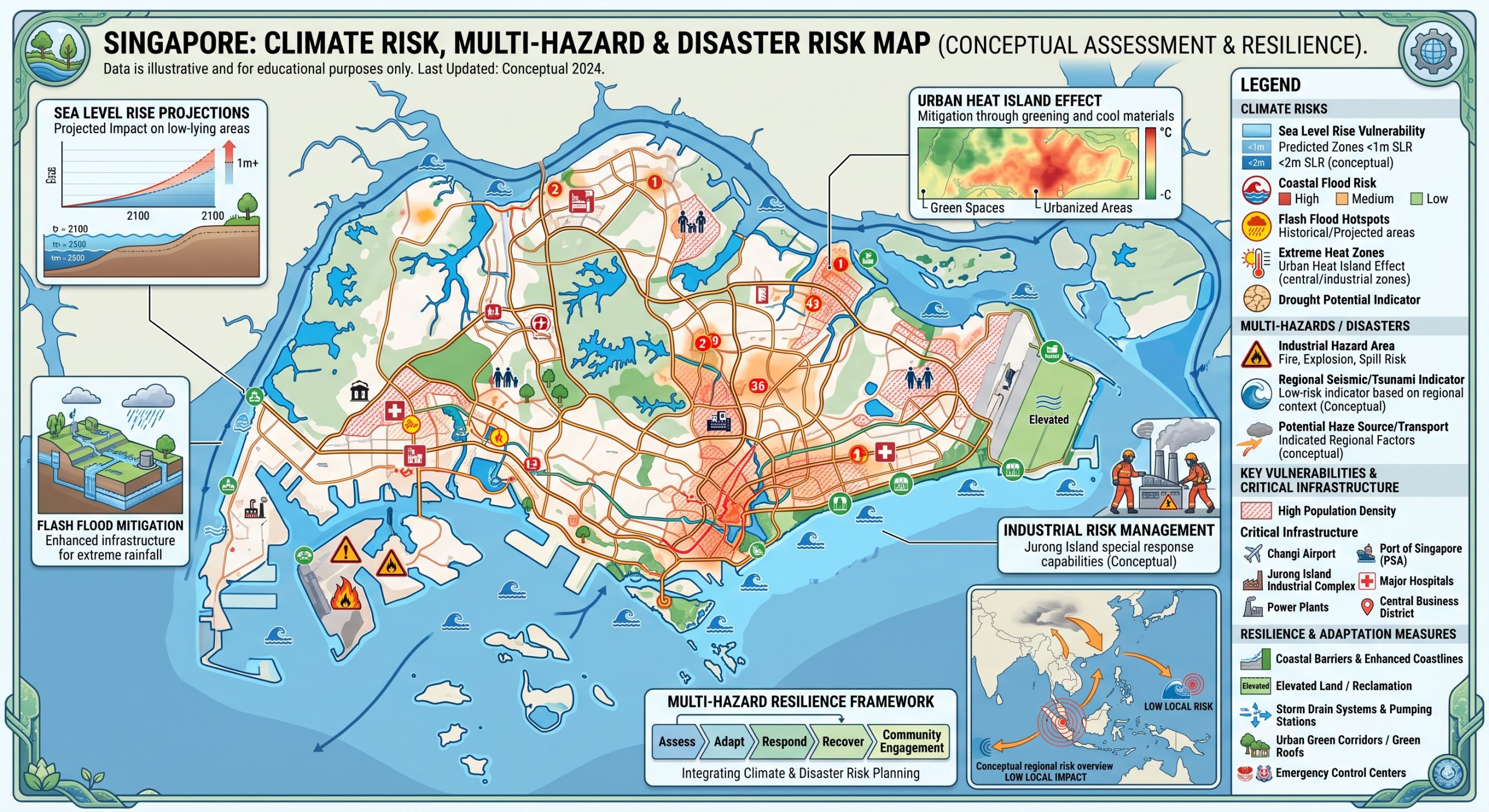
Singapore is a highly urbanised, densely populated and economically concentrated tropical island city-state whose disaster-risk profile differs substantially from that of larger countries. It has relatively low exposure to tropical-cyclone landfall, major local earthquakes, large river floods, volcanic eruptions and drought-driven humanitarian crises. However, its very high concentration of population, critical infrastructure, transport networks, financial and commercial assets within a small, low-lying coastal territory creates significant systemic and cascading risk.
The dominant climate and multi-hazard threats are:
extreme heat and humid heat stress;
short-duration extreme rainfall and flash or pluvial flooding;
sea-level rise and coastal inundation;
high tides and storm surges;
prolonged dry periods and water-security stress;
lightning and severe thunderstorms;
Sumatra squalls and damaging wind gusts;
transboundary smoke haze and PM2.5 pollution;
dengue and other climate-sensitive infectious diseases;
rainfall-induced slope instability;
treefall during intense storms;
low-probability regional earthquake and tsunami effects;
industrial, chemical and hazardous-material emergencies;
critical-infrastructure and supply-chain disruption;
external climate shocks affecting food, energy and trade.
Singapore’s annual mean temperature rose by about 0.24°C per decade from 1984 to 2022, while annual rainfall increased by about 83 mm per decade between 1980 and 2022. Mean sea level around Singapore is projected to rise by approximately 0.23 to 1.15 metres by 2100. About 30% of Singapore lies less than 5 metres above the Singapore Height Datum, making long-term coastal risk particularly important. (National Climate Change Secretariat)
The national risk profile can be summarized through several important cascading pathways:
Extreme heat + high humidity → human heat stress → reduced outdoor productivity → greater cooling demand → higher electricity demand → pressure on energy and water systems.
Extreme rainfall → rapid urban runoff → overwhelmed drains and canals → road and underpass flooding → transport disruption → delayed emergency services and economic interruption.
Sea-level rise + extreme high tide + storm surge + heavy rainfall → coastal and inland compound flooding → infrastructure disruption → cascading impacts on transport, electricity, telecommunications and businesses.
Regional drought and vegetation fires → transboundary haze → elevated PM2.5 → health impacts → restrictions on outdoor work, education, recreation and events.
Singapore therefore has comparatively strong coping capacity but potentially high consequence concentration. The main challenge is increasingly not whether an individual hazard can be controlled, but whether multiple interconnected systems remain operational under increasingly severe climatic extremes.
2. Geographic and development context
Singapore is a small island state at the southern end of the Malay Peninsula. Its development pattern is intensely urban, infrastructure-dependent and coastal.
Important risk zones include:
Geographic zone | Main characteristics | Principal risk issues |
|---|---|---|
Central and Downtown Singapore | Dense commercial, government and transport assets | Heat, extreme rainfall, flash flooding, infrastructure interdependency |
Marina Bay and City-East Coast | Low-lying waterfront development and major assets | Coastal flooding, sea-level rise, high tide, storm surge |
East Coast-Changi | Airport, parks, housing, transport and coastal infrastructure | Sea-level rise, coastal flood, extreme rainfall |
Jurong Island-Tuas | Petrochemical, industrial, port and water infrastructure | Coastal flood, HazMat/Natech risk, heat, storms |
Northwest and Lim Chu Kang | Reservoirs, agriculture, wetlands and low-lying coast | Sea-level rise, water management, ecosystem vulnerability |
Punggol-Pasir Ris-Lorong Halus | Rapid urban development near waterways and coast | Extreme rainfall, coastal flooding and drainage interaction |
Southern Waterfront-Sentosa | Tourism, recreation, port and future urban development | Coastal inundation and storm surge |
Bukit Timah and other elevated terrain | Steeper natural and engineered slopes | Rainfall-induced slope instability and treefall |
Offshore islands | Strategic, ecological, industrial and defence uses | Coastal flooding, erosion, sea-level rise |
By 2026, PUB’s site-specific coastal studies, including those for the southwest coast and Sentosa, are intended to cover more than 80% of Singapore’s coastline. (Publications.sg)
3. Climate characteristics
Singapore has an equatorial tropical climate characterized by:
high temperatures throughout the year;
high humidity;
abundant rainfall;
frequent thunderstorms;
relatively weak seasonal temperature variability;
Northeast and Southwest monsoon regimes;
two inter-monsoon periods.
The 1991-2020 climatic normal gives an annual mean temperature of approximately 27.8°C and annual rainfall of around 2,534 mm. (National Environment Agency)
Seasonal pattern
The Northeast Monsoon, approximately December to early March, includes a wetter phase when monsoon surges can produce prolonged heavy rain.
The Southwest Monsoon, approximately June to September, is generally drier but is associated with Sumatra squalls, gusty winds and occasional periods conducive to transboundary haze.
The inter-monsoon periods are associated with light winds, strong convective development, thunderstorms and very frequent lightning.
4. Observed climate change
4.1 Rising temperature
Singapore’s annual mean temperature has increased at approximately 0.24°C per decade since 1984. (National Climate Change Secretariat)
The trend is accompanied by:
more very hot days;
warmer nights;
greater heat stress;
increased urban thermal discomfort;
higher cooling requirements.
Singapore’s latest climate-resilience planning uses Wet Bulb Globe Temperature, or WBGT, because temperature alone does not represent the combined effects of humidity, solar radiation and wind. (Meteorological Service Singapore)
The warming signal is already evident. Singapore’s average temperature in 2025 was 28.1°C, placing the year among its ten warmest despite the cooling influence of La Niña. (Meteorological Service Singapore)
4.2 Increasing rainfall
Annual rainfall has also shown an increasing trend.
Singapore’s 2025 assessment found:
2025 was the 7th wettest year since 1980;
islandwide rainfall reached 2,984.9 mm;
March 2025 was the wettest March recorded;
average rainfall on wet days has increased;
annual rainfall increased by about 92.5 mm per decade over 1980-2025. (Meteorological Service Singapore)
The principal disaster-management concern is therefore not merely total rainfall but short-duration rainfall intensity.
5. Future climate projections
Singapore’s Third National Climate Change Study, V3, released in 2024, projects:
significantly higher temperatures;
substantially more very hot days;
stronger heat stress;
wetter rainfall extremes;
potentially longer dry spells;
accelerating sea-level rise. (National Climate Change Secretariat)
A particularly important heat indicator is the number of days when maximum air temperature exceeds 35°C.
Singapore currently experiences an average of about 21.4 very hot days per year. Under a high-emissions scenario this could increase to approximately 129 days annually by 2050. (National Climate Change Secretariat)
By late century, high heat stress could become a regular feature of Singapore’s climate rather than an occasional extreme. (Urban Redevelopment Authority (URA))
6. Indicative national multi-hazard risk matrix
The ratings below are an analytical synthesis rather than an official government classification.
Hazard | Indicative risk | Trend |
|---|---|---|
Extreme heat and humid heat | Very High | Strongly increasing |
Flash/pluvial flooding | High | Increasing |
Sea-level rise and coastal flooding | Very High long-term | Strongly increasing |
Extreme rainfall | High | Increasing |
Water scarcity/dry periods | Moderate-High systemic | Increasing variability |
Lightning | High recurrent | Climate-sensitive |
Sumatra squalls/strong winds | Moderate-High | Variable |
Transboundary haze | Moderate-High episodic | Regional/climate-sensitive |
Dengue/vector-borne disease | High | Climate-sensitive |
Coastal erosion | Moderate-High locally | Increasing |
Rainfall-induced slope failure | Low-Moderate locally | Increasing rainfall concern |
Treefall/storm damage | Moderate | Linked to severe weather |
Industrial/HazMat emergencies | High consequence locally | Persistent |
Natech events | Moderate-High consequence | Increasing climate interaction |
Earthquake | Low locally | Stable |
Tsunami | Very Low-Low | Stable |
Tropical-cyclone landfall | Very Low | Low, although indirect effects possible |
Food-supply disruption | High systemic external risk | Increasing global climate exposure |
Critical-infrastructure cascading failure | High consequence | Increasing system complexity |
7. Extreme heat and humid heat stress
Extreme heat is likely to become one of Singapore’s most important climate threats.
Unlike dry-climate heat, Singapore’s heat occurs under high humidity. This reduces the body’s ability to cool itself through evaporation.
Heat risk is therefore driven by:
temperature + humidity + solar radiation + wind + physical activity + exposure duration + individual health condition.
MSS consequently monitors WBGT as its operational heat-stress indicator. (Meteorological Service Singapore)
In 2025, Singapore recorded 29 days of high heat stress, defined by an hourly average WBGT of at least 33°C at a monitoring location. The highest 15-minute WBGT recorded was 35.0°C at Sentosa Palawan Green on 31 October 2025. The national WBGT network had expanded to 20 operational stations by early 2026. (Meteorological Service Singapore)
Particularly vulnerable populations
outdoor construction workers;
delivery and logistics workers;
cleaners and landscaping workers;
security personnel;
transport workers;
athletes;
children;
older persons;
persons with cardiovascular or respiratory illness;
persons with renal disease;
residents of poorly ventilated environments.
Cascading effects
Extreme heat can cause:
heat exhaustion and heat stroke;
reduced labour productivity;
greater electricity demand;
increased air-conditioning use;
additional cooling requirements in buildings and transport;
thermal stress on infrastructure;
increased demand on hospitals and emergency services.
Singapore established a Heat Resilience Policy Office in 2026 to coordinate policy across health, infrastructure, economic and social sectors and to develop a Heat Resilience Action Plan. (Sustainable Environment Ministry)
8. Urban heat-island vulnerability
Urbanisation compounds regional warming.
Dense buildings, asphalt, concrete, machinery and air-conditioning systems:
absorb solar radiation;
retain heat;
reduce nighttime cooling;
emit anthropogenic heat;
restrict airflow in poorly designed urban configurations.
Singapore is responding through:
urban climate modelling;
wind-corridor planning;
tree and vegetation strategies;
cool materials;
building-energy efficiency;
district cooling;
climate-responsive urban design.
The Cooling Singapore work and digital urban-climate modelling are being used to identify heat hotspots and evaluate interventions. (Urban Redevelopment Authority (URA))
9. Extreme rainfall and flash-flood risk
Flood risk has been reduced dramatically but has not been eliminated.
Flood-prone land decreased from around 3,200 hectares in the 1970s to less than 30 hectares today, reflecting major investments in drainage, canals, reservoirs and flood-management infrastructure.
However, extremely intense rainfall can temporarily exceed drainage capacity.
Singapore’s flash floods are generally:
localized;
rapid-onset;
rainfall-driven;
relatively short-duration;
capable of inundating roads and low points within minutes.
PUB notes that localized flash floods generally subside within about an hour.
Principal causes
severe thunderstorms;
monsoon surges;
Sumatra squalls;
highly impervious urban surfaces;
local topographic depressions;
drainage capacity exceedance;
simultaneous high tides affecting drainage.
10. Flood-monitoring and forecasting capability
Singapore operates one of the more highly instrumented urban flood-monitoring networks internationally.
PUB’s Catchment and Waterways Operations System integrates information from:
more than 1,000 water-level sensors;
more than 500 CCTV cameras;
rain gauges;
weather radar;
flood-response vehicles.
The Joint Operations Centre operates continuously.
PUB also uses X-band weather radar to provide rainfall forecasts around 30 minutes ahead, supporting anticipatory deployment of Quick Response Teams.
This is an important strength, although convective rainfall can still develop and intensify quickly.
11. Coastal flooding and sea-level rise
Sea-level rise is Singapore’s most important long-term physical climate hazard.
Approximately 30% of Singapore is less than 5 metres above mean sea level. (Publications.sg)
V3 projects mean sea level around Singapore to rise approximately:
0.23-1.15 metres by 2100, with further rise beyond 2100 potentially reaching around 2 metres by 2150 under high-end projections. (Publications.sg)
Coastal flooding can result from the combination of:
sea-level rise + astronomical high tide + storm surge + wave action + extreme rainfall + drainage constraints.
PUB reports that high tides may reach approximately 3.5 metres, and Singapore already experiences occasional coastal flooding where high tides coincide with heavy rain, including at East Coast Park.
12. Storm-surge risk
Singapore does not normally experience direct major tropical-cyclone landfall because of its near-equatorial location.
However, tropical cyclones elsewhere in the region can influence winds and sea levels.
PUB estimates Singapore experiences approximately 2-4 storm-surge events annually.
The danger increases as mean sea level rises because even an unchanged storm surge would begin from a higher baseline.
13. Major coastal-risk hotspots
City-East Coast
Includes:
Greater Southern Waterfront;
Marina Bay;
East Coast;
Changi.
This is one of Singapore’s highest-value coastal corridors.
PUB’s completed City-East Coast study recommends combinations of:
coastal barriers;
raised shoreline structures;
seawalls and revetments;
tidal gates;
Long Island;
adaptive protection measures. (Publications.sg)
Changi
Major exposed assets include:
Changi Airport;
transport systems;
aviation facilities;
coastal parks;
commercial infrastructure.
Singapore has already adopted higher design elevations for new critical infrastructure. New facilities such as Changi Airport Terminal 5 and Tuas Mega Port are to be constructed at least 5 metres or more above current mean sea level. (Publications.sg)
Jurong Island and Tuas
This area combines:
petrochemical and chemical installations;
port infrastructure;
water facilities;
industrial plants;
coastal exposure.
The result is significant Natech risk, where natural hazards trigger technological emergencies.
Northwest Coast
Includes low-lying reservoir, agricultural and ecological areas.
Protection planning must balance:
coastal defences;
reservoir operations;
wetlands;
recreation;
agriculture;
future land-use needs.
Sentosa and southern islands
Principal risks include:
sea-level rise;
wave action;
coastal erosion;
storm surge;
tourism disruption.
PUB is expanding coastal-risk studies to Sentosa and several offshore islands. (Publications.sg)
14. Coastal protection strategy
Singapore’s coastal adaptation follows a multi-layered approach involving:
a continuous coastal line of defence;
adaptable infrastructure that can be raised or modified;
development-level flood-resilience measures;
public and institutional flood preparedness.
Potential structures include:
dykes;
seawalls;
tidal gates;
coastal barriers;
deployable barriers;
raised land and reclamation;
nature-based shoreline treatments. (Publications.sg)
In June 2026, PUB completed a new Code of Practice on Coastal Protection, establishing planning, design, operational, inspection and maintenance requirements for coastal defences. (Publications.sg)
15. Water-security and drought risk
Singapore receives abundant annual rainfall but remains highly water-stressed because of:
limited territory for catchments and storage;
absence of large natural freshwater systems;
high population density;
high industrial demand;
climate variability.
Prolonged dry periods can reduce local catchment inflows and affect imported-water sources.
Singapore therefore operates the Four National Taps:
local catchment water;
imported water;
NEWater;
desalinated water.
NEWater and desalinated water are considered weather-resilient sources because they are substantially less dependent on rainfall. (National Climate Change Secretariat)
This means Singapore has high intrinsic water scarcity but substantially reduced operational vulnerability because of infrastructure, diversification and governance.
Nevertheless, future water demand could almost double by 2065, requiring continuing expansion of weather-resilient supply and water efficiency. (Publications.sg)
16. Water-energy nexus
Singapore’s water security is closely connected to its energy system.
NEWater and desalination improve drought resilience but require substantial electricity.
Consequently:
prolonged drought → greater reliance on weather-resilient sources → increased treatment and desalination → additional electricity requirements.
Similarly:
energy disruption → water-treatment/pumping disruption → potential water-system consequences.
This makes power-water interdependency an important component of critical-infrastructure resilience.
17. Lightning hazard
Singapore is one of the world’s most lightning-active environments.
Meteorological Service Singapore records an average of approximately 176 lightning days annually at the Changi climate station. Lightning activity is generally greatest around November, April and May during inter-monsoon periods. (Meteorological Service Singapore)
Lightning threatens:
outdoor workers;
construction sites;
sports facilities;
schools;
aviation;
maritime operations;
electrical equipment;
communications systems.
Singapore maintains a real-time lightning detection and warning service. (Meteorological Service Singapore)
18. Sumatra squalls and strong winds
Sumatra squalls are organized thunderstorm lines that develop over Sumatra or the Strait of Malacca and travel eastward toward Singapore.
They may bring:
sudden strong winds;
torrential rainfall;
lightning;
treefall;
temporary transport disruption.
Typical squall wind gusts can reach 40-80 km/h, while maximum gusts of up to approximately 93 km/h have been recorded. (Meteorological Service Singapore)
Strong winds can damage:
trees;
temporary structures;
construction equipment;
roofs;
outdoor installations;
port and maritime operations.
19. Waterspouts and localized severe weather
Waterspouts occur occasionally over Singapore’s surrounding waters.
MSS reports an average of roughly three observed waterspout occurrences per year. They can generate strong winds of 40-80 km/h over water and may pose hazards to swimmers, small vessels and recreational maritime activities. (Meteorological Service Singapore)
Their national disaster significance is low, but they are relevant within Singapore’s broader severe-weather risk portfolio.
20. Transboundary haze and air-quality risk
One of Singapore’s most important transboundary environmental hazards is smoke haze generated by forest and peat fires elsewhere in Southeast Asia.
Risk varies according to:
fire activity in Sumatra and Kalimantan;
rainfall;
El Niño and regional drought;
wind direction;
peat dryness.
PM2.5 is the main pollutant of health concern during severe haze. NEA considers a 24-hour PSI above 100 to be unhealthy. (National Environment Agency)
Sensitive populations include:
children;
older people;
pregnant women;
persons with asthma;
people with chronic lung or heart disease;
outdoor workers.
Singapore’s Haze Task Force involves 28 government agencies, while NEA and MSS support regional monitoring through the ASEAN Specialised Meteorological Centre. (National Environment Agency)
21. Dengue and climate-sensitive disease
Dengue is endemic in Singapore.
Transmission is influenced by:
Aedes mosquito populations;
temperature;
rainfall;
humidity;
circulating dengue serotypes;
population immunity;
human behaviour and mobility.
Warmer temperatures can accelerate mosquito development and viral replication. Climate change and changing weather patterns may therefore compound dengue risk. (National Environment Agency)
Singapore recorded over 13,600 dengue cases in 2024, falling to slightly more than 4,000 in 2025 following extensive mosquito-control efforts, including Project Wolbachia. (National Environment Agency)
The risk remains significant because Singapore combines:
high population density;
year-round tropical temperatures;
international travel;
multiple circulating serotypes.
22. Rainfall-induced slope instability
Singapore has limited natural mountainous terrain, so landslide risk is much lower than in neighbouring Indonesia or Malaysia.
However, rainfall-induced slope failure is the country’s most relevant landslide mechanism.
BCA states that slope stability decreases as groundwater rises during rainstorms and specifically requires slope design to incorporate more onerous groundwater conditions considering climate-change impacts. (Building and Construction Authority)
Potential risk locations include:
Bukit Timah;
Mount Faber;
Kent Ridge;
engineered embankments;
road cuttings;
construction sites;
steep landscaped areas.
The overall national risk is low to moderate but locally important during prolonged intense rainfall.
23. Treefall and urban greenery risk
Singapore’s extensive urban greenery provides cooling, biodiversity and recreational benefits but also introduces localized storm risk.
Climate change may increase the risk of treefall through:
strong winds;
saturated soils;
intense rainfall;
root instability;
lightning.
Singapore’s climate adaptation framework specifically identifies severe storms and heavy rainfall as factors that may increase treefall risk. (Sustainable Environment Ministry)
Regular tree inspection and urban-forest management are therefore part of infrastructure and public-safety resilience.
24. Earthquake risk
Singapore lies outside major earthquake zones and has low local seismic hazard.
However, large earthquakes in Sumatra can occasionally produce perceptible long-period tremors in high-rise buildings.
BCA states that Singapore’s buildings are generally safe from earthquakes and are designed to withstand distant tremors. (Building and Construction Authority)
The main concern is therefore:
low probability + high asset concentration + distant seismic excitation.
Sensitive systems include:
high-rise buildings;
hospitals;
industrial installations;
data centres;
bridges;
energy and transport systems.
NEA operates five seismic stations that continuously monitor regional earthquakes. (National Environment Agency)
25. Tsunami risk
Singapore’s tsunami risk is low because:
it is protected geographically by surrounding land masses;
it lies inside the relatively enclosed Singapore Strait;
major tsunami-generating subduction zones are distant.
Nevertheless, monitoring is maintained because extremely large regional earthquakes can have far-reaching consequences.
Singapore’s seismic information feeds into the national tsunami early-warning system and the wider Indian Ocean Tsunami Warning and Mitigation System. (National Environment Agency)
For national planning, coastal flooding from sea-level rise, tides and storm surge is substantially more important than tsunami risk.
26. Industrial and technological disaster risk
Singapore is one of Asia’s largest industrial, petrochemical, port and logistics hubs.
Major concentrations include:
Jurong Island;
Tuas;
Pulau Bukom;
western industrial areas;
major ports and logistics terminals.
Potential emergencies include:
industrial fire;
explosion;
chemical leakage;
toxic gas release;
hazardous-material transport accident;
oil spill;
infrastructure disruption.
SCDF has dedicated HazMat mitigation capabilities and maintains specialized resources around Jurong Island and other industrial zones. (Ministry of Home Affairs)
27. Natech risk
Climate change makes natural-hazard-triggered technological emergencies, or Natech events, increasingly important.
Potential pathways include:
Extreme rainfall
Flood → electrical/control system damage → industrial shutdown or chemical release.
Coastal flooding
Storm surge + sea-level rise → industrial/coastal facility inundation → hazardous-material incident.
Extreme heat
Heat → equipment thermal stress → cooling-system failure → process disruption.
Lightning
Lightning strike → ignition → industrial fire or electrical failure.
Strong wind
Squall → structural/component damage → secondary technological emergency.
For Singapore, Natech risk deserves particular attention because industrial facilities and critical infrastructure are concentrated within a small geographical area.
28. Critical-infrastructure vulnerability
Singapore’s infrastructure is highly engineered but strongly interconnected.
Key systems include:
electricity;
water;
telecommunications;
data centres;
Changi Airport;
Tuas and PSA port systems;
MRT and rail infrastructure;
expressways;
hospitals;
drainage and pumping;
industrial estates;
financial and digital systems.
Climate change can affect essential services through intense rainfall, rising sea level, strong winds and higher temperatures. (Sustainable Environment Ministry)
The principal risk is therefore not necessarily physical destruction but network disruption.
For example:
Flash flood → road closure → ambulance delay → hospital-access disruption.
Or:
Power failure → telecommunications + cooling + pumping + digital-services disruption.
29. Food-security vulnerability
Singapore imports more than 90% of its food. (Sustainable Environment Ministry)
This creates substantial exposure to disasters occurring outside Singapore.
Potential pathways include:
drought in producing country → crop failure → lower exports → higher Singapore food prices.
tropical cyclone → damaged regional port → shipping disruption → delayed imports.
animal disease → export restriction → reduced food supply.
global heat and water stress → declining agricultural production → sustained price pressure.
Food security should therefore be regarded as a transboundary climate and disaster risk, even when Singapore itself is not directly affected.
The current national strategy combines:
diversified import sources;
global partnerships;
strategic stockpiles;
domestic production. (Sustainable Environment Ministry)
30. Local agriculture vulnerability
Singapore’s agricultural sector is small but strategically important.
Urban and controlled-environment farming can be exposed to:
heat;
energy interruption;
extreme rainfall;
flooding;
pests and disease;
supply disruption for feed and agricultural inputs.
High-tech farming also introduces infrastructure dependencies:
power disruption → ventilation/cooling failure → crop or livestock loss.
Resilience therefore requires backup energy, water security, disease surveillance and climate-controlled production systems.
31. Biodiversity and ecosystem vulnerability
Singapore contains:
mangroves;
coastal mudflats;
coral reefs;
seagrass;
freshwater wetlands;
secondary forests;
urban biodiversity.
Climate change could alter:
species distributions;
flowering and breeding cycles;
ecosystem productivity;
soil processes;
coastal habitats;
coral health.
NCCS notes that a mean warming of around 1.5-2.5°C could significantly affect Singapore’s natural ecosystems. (National Climate Change Secretariat)
Mangroves and coastal wetlands are particularly important because they also provide natural flood, erosion and wave-attenuation benefits.
32. Marine and coastal ecosystem risk
Sea-level rise and ocean warming threaten:
mangroves;
intertidal flats;
coral reefs;
seagrass beds;
marine biodiversity.
Hard coastal protection may also affect ecosystems if not carefully designed.
Singapore therefore faces an important adaptation trade-off:
protect urban coastline + maintain shipping/access + conserve ecosystems + accommodate future sea-level rise.
Coastal adaptation increasingly requires hybrid engineering and nature-based approaches rather than uniform seawalls.
33. Social vulnerability
Singapore’s high national income and strong public infrastructure significantly reduce disaster vulnerability compared with many countries.
However, risk is not equally distributed.
Potentially more vulnerable groups include:
elderly persons;
persons with disabilities;
low-income households;
persons living alone;
persons with chronic illnesses;
outdoor workers;
migrant workers;
children;
people dependent on medical equipment or continuous cooling.
Heat vulnerability
Outdoor workers face disproportionately high occupational heat exposure.
Digital dependency
Warnings increasingly rely on smartphones and digital channels, which requires appropriate alternatives for:
older people;
persons with disabilities;
persons with limited digital literacy.
Mobility limitations
Flood, fire or other emergency evacuation planning should incorporate persons requiring assistance.
34. Key geographic multi-hazard hotspots
34.1 Downtown-Marina Bay
Dominant risks:
extreme heat;
coastal flooding;
high tide;
extreme rainfall;
critical-infrastructure disruption.
High economic and strategic asset concentration makes consequences potentially national.
34.2 East Coast-Changi
Dominant risks:
sea-level rise;
high tide;
coastal flooding;
extreme rainfall;
aviation disruption.
This is one of the principal national coastal-adaptation zones. (Publications.sg)
34.3 Punggol-Pasir Ris-northeast
Dominant risks:
extreme rainfall;
urban flood;
coastal exposure;
heat.
Rapid urbanisation requires continual drainage and coastal-risk updating.
34.4 Jurong Island-Tuas
Dominant risks:
coastal inundation;
extreme rainfall;
industrial fire/explosion;
HazMat;
Natech;
heat;
port disruption.
This is arguably Singapore’s most important industrial multi-hazard hotspot.
34.5 Southern Waterfront-Sentosa
Dominant risks:
sea-level rise;
storm surge;
tourism disruption;
coastal erosion.
Future development creates both additional exposure and an opportunity to incorporate resilience from the outset.
34.6 Bukit Timah and elevated terrain
Dominant risks:
intense rainfall;
slope instability;
treefall;
localized flash runoff.
35. Major compound and cascading scenarios
Heat-energy-health cascade
Extreme heat → air-conditioning demand → electricity peak → system stress → health risk if cooling is interrupted.
Rainfall-flood-transport cascade
Extreme thunderstorm → flash flood → underpass/road closure → traffic congestion → emergency-service delay.
Coastal compound flooding
Sea-level rise + high tide + storm surge + intense rainfall → reduced drainage → inland and coastal flooding simultaneously.
Haze-health-economic cascade
Regional drought → peat/forest fire → haze → PM2.5 exposure → outdoor restrictions → productivity and health impacts.
Food-supply cascade
External drought/flood/cyclone → agricultural loss overseas → export restrictions/logistics disruption → Singapore supply and price effects.
Natech cascade
Flood/heat/lightning → industrial facility failure → hazardous-material incident → evacuation and business interruption.
36. Early-warning and monitoring capacity
Singapore has very strong observation and monitoring capacity.
Major systems include:
Meteorological Service Singapore weather radar;
automatic weather stations;
lightning detection;
WBGT monitoring;
regional haze satellite monitoring;
seismic network;
tsunami monitoring;
PUB water-level sensors;
CCTV flood surveillance;
rainfall gauges;
flood forecasting;
regional earthquake alerts;
air-quality monitoring.
The myENV platform integrates public information and alerts for:
weather;
heavy rain;
flood conditions;
drain water levels;
lightning;
haze;
dengue;
air quality;
earthquakes;
water disruptions. (National Environment Agency)
This represents a comparatively advanced multi-hazard public-information platform.
37. Disaster-response capacity
The Singapore Civil Defence Force provides:
24-hour firefighting;
rescue;
emergency medical services;
hazardous-material mitigation;
fire-safety regulation;
community emergency preparedness. (Ministry of Home Affairs)
Singapore’s principal institutional advantage is the ability to integrate technical monitoring with well-resourced emergency response.
The next level of resilience is increasingly about moving beyond hazard warning toward impact-based and cascading-risk intelligence.
38. Remaining risk-management challenges
Despite Singapore’s strong capacity, several issues require continued attention.
1. Extreme rainfall exceeding design capacity
PUB explicitly recognises that it is neither practical nor cost-effective to build drainage capable of accommodating every conceivable extreme rainfall event. (Publications.sg)
2. Compound coastal-inland flooding
Heavy rainfall and extreme sea levels need to be modelled together rather than independently.
Singapore’s Coastal-Inland Flood Model is already being used for this purpose. (Publications.sg)
3. Heat forecasting at neighbourhood scale
National WBGT monitoring should increasingly connect with:
urban morphology;
shade;
work intensity;
vulnerable populations;
indoor thermal conditions.
4. Critical-infrastructure interdependency
Power, water, transport, telecommunications, digital infrastructure and healthcare must be analysed as connected systems.
5. Natech risk
Climate hazards should be fully integrated into industrial emergency and business-continuity planning.
6. Food and supply-chain risk
Singapore’s resilience depends partly on climate conditions thousands of kilometres beyond its borders.
7. Long-term adaptation uncertainty
Sea-level rise continues beyond 2100, requiring adaptive infrastructure rather than single fixed design levels.
39. Priority actions for strengthening resilience
39.1 Develop a fully integrated national multi-hazard risk-intelligence platform
Integrate:
weather radar;
rainfall;
drainage;
coastal water levels;
WBGT;
lightning;
haze;
epidemiological information;
infrastructure;
transport;
industrial risk;
emergency-resource locations.
The platform should transition from:
“What hazard is occurring?”
toward:
“What will be affected, when, how severely, and what protective action must be completed?”
39.2 Expand impact-based flash-flood forecasting
Use:
radar nowcasting;
AI rainfall prediction;
urban digital twins;
drainage telemetry;
CCTV analytics;
road flood-depth sensors;
traffic data.
Warnings could identify:
specific roads;
underpasses;
MRT access points;
hospitals;
schools;
industrial facilities likely to be affected.
39.3 Develop a dynamic coastal digital twin
A national coastal-risk platform should integrate:
LiDAR terrain + bathymetry + sea-level rise + tide + storm surge + rainfall + drainage + groundwater + infrastructure + land use.
This would support adaptive protection planning through 2100 and beyond.
39.4 Expand neighbourhood-scale heat warning
Integrate:
WBGT;
urban heat modelling;
shade;
occupation;
age;
health vulnerability;
outdoor events.
This would enable location-specific action rather than uniform city-wide heat advice.
39.5 Strengthen infrastructure interdependency modelling
Undertake simulations such as:
power outage → telecom failure → traffic-system disruption → pumping limitations → emergency-response delay.
This would reveal hidden vulnerabilities that conventional asset-by-asset risk assessment may miss.
39.6 Strengthen Natech preparedness
Jurong Island, Tuas, Pulau Bukom and other industrial areas should maintain compound scenarios covering:
extreme rainfall;
coastal inundation;
lightning;
extreme heat;
strong winds;
chemical release.
39.7 Expand nature-based coastal adaptation
Where technically appropriate, use:
mangrove restoration;
vegetated shorelines;
intertidal habitats;
ecological revetments;
multifunctional coastal infrastructure.
These can complement rather than replace engineered defences.
39.8 Maintain water-system redundancy
Continue expanding:
NEWater;
desalination;
reservoir integration;
recycling;
industrial water efficiency;
strategic storage;
energy-efficient water treatment.
Singapore’s diversified Four National Taps are a major resilience asset. (National Climate Change Secretariat)
39.9 Strengthen food-system anticipatory intelligence
A national food-security risk dashboard could combine:
global drought;
crop forecasts;
cyclone tracks;
livestock disease;
shipping conditions;
port disruptions;
commodity prices;
export restrictions.
This is particularly important for a country importing more than 90% of its food. (Sustainable Environment Ministry)
40. Strategic national multi-hazard priorities
Strategic system | Priority |
|---|---|
1. National Heat Resilience System | Heat-health warning, urban cooling, worker protection |
2. Coastal and Sea-Level Rise Resilience System | Coastal barriers, Long Island, adaptive defences |
3. Urban Flood Resilience System | Radar, drainage, sensors, digital flood modelling |
4. Water-Energy Security System | Four National Taps, energy redundancy, demand management |
5. Haze-Air Quality-Health System | ASEAN monitoring, PSI/PM2.5 forecasting, health action |
6. Vector-Borne Disease Risk System | Dengue surveillance, climate-health forecasting |
7. Industrial and Natech Risk System | Jurong Island, Tuas, HazMat, climate stress testing |
8. Food and Supply-Chain Resilience System | Diversification, stockpiles, global climate intelligence |
9. Critical Infrastructure Continuity System | Power, ICT, transport, health and water interdependencies |
10. Integrated Multi-Hazard Warning System | Common risk intelligence, impact forecasting and emergency operations |
41. Overall disaster-risk outlook
Singapore’s future disaster-risk profile will be dominated less by conventional catastrophic hazards and increasingly by climate-driven compound, cascading and systemic risks.
The five most important long-term threats are:
Extreme heat and humid heat stress
Sea-level rise and coastal flooding
Short-duration extreme rainfall and flash flooding
Water, food and supply-chain vulnerability
Critical-infrastructure interdependency
Its comparatively low geological hazard and absence of direct major tropical-cyclone exposure should not be interpreted as low overall disaster risk.
Singapore’s exposure is highly concentrated:
small territory + dense population + major economic assets + coastal infrastructure + digital dependency + global supply-chain dependence.
Its principal resilience advantage is equally significant:
strong institutions + advanced engineering + dense observation networks + high technological capability + long-term planning + substantial financial capacity.
Singapore has already reduced flood-prone land from thousands of hectares to less than 30 hectares, operates more than 1,000 water-level sensors and hundreds of flood-monitoring cameras, is expanding heat-stress monitoring, has legislated for long-term coastal protection and is undertaking coastal studies covering most of its shoreline. (Publications.sg)
The next stage should therefore be the transition from well-managed individual hazards toward integrated systemic risk governance, linking:
Earth observation + meteorological radar + urban sensors + coastal/ocean monitoring + climate projections + GIS + AI + digital twins + impact-based forecasting + Common Alerting Protocol-compatible multi-channel warning + critical-infrastructure modelling + anticipatory action + emergency operations.
Such an architecture would allow Singapore not simply to know that heavy rain, extreme heat or coastal inundation is approaching, but to predict which people, roads, hospitals, ports, industrial facilities, utilities and supply chains are likely to be affected, when impacts will occur, how severe they may become and what actions must be initiated before disruption begins.
Singapore – National implementation of the ASEAN Agreement on Disaster Management and Emergency Response (AADMER)
Overview of the DRM System
Singapore has a Type C DRM System – A specific law on disasters, focused on emergency preparedness and response to natural hazards, some technological hazards; and may have elements of early warning and recovery. These laws tend to be found in countries (i) with low hazard exposure, or (ii) with higher exposure but effective risk governance through sectoral laws, or (iii) with higher exposure but limited law-making and institutional capacity due to poverty and/or conflict.
- Legal framework
- Key national institutions
- Sub-national structures
- Funding and budget
- Integration of the AADMER and AHA Centre
- Provision on international and regional assistance

Ensuring Civil Defence and Emergency Preparedness
The Singapore Civil Defence (SCDF) provides firefighting, rescue, emergency medical services and hazardous materials mitigation. It also formulates, implements and enforces regulations on fire safety and civil defence shelter matters.
What We Do
The role of the SCDF is to provide:
- Emergency Response –24-hour firefighting, rescue, mitigation of hazardous incidents and emergency medical services
- Fire Safety and Public Protection – formulating and enforcing regulations on fire safety and civil defence shelter matters
- Community Engagement – enhancing the resilience and emergency preparedness of the civil population, and promoting community first response

Legislation
Our laws on fire safety, civil defence and emergency preparedness include the following:
- The Civil Defence Act provides for the raising, maintenance and discipline of a civil defence force and for the exercise of the functions and powers of the Force during national emergencies and day-to-day operations
- The Fire Safety Act makes provisions for the fire safety of buildings and to give SCDF the necessary legislative levers to maintain regulatory oversight over relevant stakeholders and take enforcement action against infringements
- The Civil Defence Shelter Act relates to the provision of civil defence shelters for use during a state of emergency and for matters connected to it

Initiatives
Civil Defence Shelter Programme
Building up our nation’s civil defence preparedness, the programme protects the civilian population from weapon effects during a war emergency and is under the SCDF’s umbrella of Total Defence.
MyResponder
The community plays a key role in SCDF’s Tiered Emergency Response Framework as our partner in delivering life-saving interventions to casualties. The MyResponder mobile app crowdsources lifesaving by alerting members of the public to nearby medical cases. These alerts will be further expanded to include fire cases.
Save-A-Life (SAL)
Launched in collaboration with the Ministry of Health, People’s Association and Singapore Heart Foundation, the SAL initiative builds a network of community first responders who are trained in performing CPF and operating AEDs to respond to cardiac arrests in their immediate vicinity.
Vision
A Trusted Home Team, A Safe and Secure Singapore.
Mission
We work together as one Home Team, and in partnership with the community, to keep Singapore safe and secure.
Core Values
In pursuing this mission, we will always remain true to our core values of Honour and Unity.
Honour
We will always carry out our mission and serve our country and our people with honour, guided by the values of bravery, impartiality, integrity and moral courage to do the right thing even in the face of personal danger and adversity. These are necessary for us to command the trust, confidence and respect of our community whom we are sworn to protect.
Unity
While individually our Departments are strong, collectively and when united as One Home Team, we are stronger. Our diversity becomes a source of strength. We work in harmony with our Home Team colleagues and fulfill our duties as a team. We put the collective mission ahead of individual interests. We draw on each other’s resources, knowledge and capabilities to keep Singapore safe and secure.
Singapore is located in the latitude 1.17 degrees and the longitude 103.51 degrees. It borders Malaysia at the Johore Straits. Singapore consists of the Singapore Island and the surrounding small islands. Plain spreads in the Singapore Island. Land area is 699 square kilometers. Located on the equator, the weather is hot and humid throughout the year. Unclear distinction between dry and rainy season. It is affected by the northeast monsoon (December to early March) the southwest monsoon (June to September). In December and April, it has high precipitation. 75 percent of the 4.59 million population is Chinese, 14 percent Malay, 9 percent Indians.
Overview of Disasters
Though Singapore is spared from natural disasters such as earthquakes, typhoons and volcanic eruptions, the challenges for the emergency services are in preventing and mitigating man-made disasters in a highly urbanised environment with many high-rise buildings and Hazardous Material (HazMat) industries.
Recent Major Disasters
Haze (June 2013-)
Singapore has been affected by severe smoke haze due to open buring and forest fires having been taken place in Sumatra Island of Indonesia periodically. It can be made worse by dry seasons.
Disaster Management System
Legal System
The Civil Defence Act (1986) provides the legal framework for, amongst other things, the declaration of a state of emergency and the mobilisation and deployment of operationally ready national service rescuers. The Fire Safety Act, and the Civil Defence Shelter Act are among the relevant acts on emergency management.
Organization
The Ministry of Home Affairs (MHA) is the principal policy-making government body for safety and security in Singapore. In the event of a national disaster, MHA leads at the strategic level of incident management. At the tactical level, Singapore Civil Defence Force (SCDF) will coordinate the planning and execution of the multi agency response to mitigate the impact of the disaster. SCDF provides effective 24-hour fire fighting, rescue and emergency ambulance services. Other functions include educating the community as well as mobilizing the community to be more involved in safety and security. SCDF also enforces fire safety requirements and oversees the civil defence shelter construction programme and the public warning system.
Plan
SCDF has developed the Operations Civil Emergency (Ops CE) Plan, a national response plan for civil emergencies which outlines the work of SCDF and all the Related Agencies (RAs)4 in the management of a major disaster. Under this plan, SCDF is overall-in-charge of the multi-agency response.
ADRC Counterpart
Singapore Civil Defence Force (SCDF)
Country Report
Country Report 2006 (Japanese Version, PDF file)
Country Report 2006 (English Version, PDF file)
Country Report 2003 (English Version, PDF file)
Country Report 2002 (English Version, PDF file)
Country Report 2001 (English Version, PDF file)
Country Report 1999 (English Version, PDF file)
Country Report 1999 (Japanese Version, PDF file)
Country Report 1998 (English Version, PDF file)
The Singapore Civil Defence Force (SCDF) is a uniformed organisation under the purview of the Ministry of Home Affairs. The main role of SCDF is to provide fire-fighting, rescue and emergency medical services; mitigating hazardous materials incidents, as well as formulate, implement and enforce regulations on fire safety and civil defence shelter matters.
In 1982, the National Civil Defence Plan was launched which spearheaded the emergency preparedness for the nation. With the enactment of the Civil Defence Act in 1986, SCDF was established as an independent organisation under the Ministry of Home Affairs (MHA). In the same year, the Hotel New World collapse paved the way for joint operations between SCDF and Singapore Fire Service (SFS). Due to the similarity in roles and functions, SCDF and SFS were formally integrated on 15 April 1989.
Over the years, SCDF has improved its life saving operations through innovations and programmes to enhance its fire-fighting, rescue capabilities and public education plans. The Light Fire Attack Vehicle (The Red Rhino) and Unmanned Fire Fighting Machine (UFM) are some of the customised solutions which SCDF has developed to increase its operational capabilities. SCDF also actively engages the local community through its wide-ranging public educational programmes and community-based activities to enhance the resilience and emergency preparedness of the civilian population.
Today, SCDF is recognised by the population as a professional body of well-trained officers and men geared to respond to all types of life-threatening emergencies round-the-clock. An operationally ready SCDF, working hand-in-hand with a prepared and resilient population, helps to ensure that the nation is capable of handling any untoward eventualities.
The AHA Centre is an intergovernmental organisation, established by the ten ASEAN Member States with the aim to facilitate cooperation and coordination of disaster management amongst ASEAN Member States. The Agreement on the Establishment of the ASEAN Coordinating Centre for Humanitarian Assistance on disaster management was signed by ASEAN Foreign Ministers on 17 November 2011, and witnessed by the Heads of State / Government of all ten ASEAN countries. In operationalising its mandate, the AHA Centre primarily works with the National Disaster Management Organisations (NDMOs) of the ASEAN Member States. Furthermore, the AHA Centre also partners with international organisations, private sector, and civil society organisations, such as the Red Cross and Red Crescent Movement, the United Nations, and AADMER Partnership Group.

VISION
MISSION

Values
Effective Disaster Response and Recovery in Singapore
Key Takeaways
Understanding Disaster Response and Recovery Framework
Definition and Importance
Phases of Disaster Management
Local vs. Global Perspectives
Singapore’s Unique Disaster Vulnerabilities
Natural Hazards
Technological Risks
Societal Challenges
Singapore’s crowded population makes disaster response harder. With over five million people in a small area, managing resources is key. Civil emergencies, a big part of past disasters, need teams to respond.
Looking at these challenges, we see the value of working together. Strong community support and good planning are essential to overcome these issues.
Government Agencies Involved in Disaster Management
National Environment Agency
Ministry of Home Affairs
Civil Defence Force
Community Engagement in Disaster Preparedness
Role of Citizens
Volunteer Programs and Initiatives
Building Resilient Neighborhoods
Disaster Response Strategies in Singapore
Emergency Services Coordination
Communication Systems
Resource Allocation
Regular drills and training, like Table-Top Exercises (TTE), help test plans. This ensures everything runs smoothly during real emergencies. By planning well, Singapore improves its disaster response and recovery.
Recovery Planning and Support
After a disaster, we need a strong plan for recovery. This plan helps people and families get back on their feet. It includes support for mental health, financial help, and fixing damaged buildings.
Psychological and Emotional Recovery
Getting over a disaster is hard. People feel stressed, anxious, and traumatized. Counseling and support groups are key to helping them heal.
These programs offer a safe place to talk and get help. They help people deal with their feelings and move forward.
Financial Assistance Programs
Financial help is vital after a disaster. It covers costs like housing, medical care, and more. This aid comes in the form of grants and loans.
It lets people and families start rebuilding their lives. This support is a big step towards recovery.
Infrastructure Rehabilitation
Fixing buildings and systems is essential. It includes repairs to utilities, roads, and hospitals. These efforts make sure services work again and make the community safer.
Keeping infrastructure strong is important. It helps prevent damage from future disasters. Regular checks and updates are needed to keep everyone safe.
| Recovery Element | Description | Importance |
|---|---|---|
| Psychological Support | Services such as counseling and community support groups. | Essential for emotional healing and resilience. |
| Financial Assistance | Grants and loans for rebuilding lives. | Alleviates financial burdens after disasters. |
| Infrastructure Rehabilitation | Restoration of essential services and systems. | Ensures community functionality and future resilience. |
In Singapore, we see the need for strong recovery plans. Recent cyberattacks on healthcare services show our weaknesses. To learn more, check this key resource.
Technology’s Role in Disaster Management
Today, technology has changed how we deal with emergencies. It helps us assess risks better, improves search and rescue, and spreads information fast. Let’s look at how GIS, drones, and social media are making a difference.
Use of GIS and Data Analytics
Geographic Information Systems (GIS) help us see and understand disaster impacts. They show us where dangers are and where floods might happen. This lets agencies make smart choices with up-to-date data, making disaster responses better.
Drones in Search and Rescue
Drones are key in disaster work, like finding people and checking damage. They fly over areas, giving us pictures and data right away. This helps find survivors fast and assess damage, saving lives.
Social Media for Information Dissemination
Social media is vital for sharing news during disasters. It lets officials reach many people quickly. Sites like Facebook help share updates and resources, building a community response.
We must keep finding new tech, like AI, to get better at predicting disasters. The tech world keeps moving, so we need to keep learning and using new tools. For more on using tech to talk to customers, see this guide on chatbot conversation design.
Training and Capacity Building
Simulation Exercises and Drills
Educational Programs for First Responders
Partnerships with NGOs
Public Awareness Campaigns
Importance of Education
Key Campaigns and Initiatives
Engaging the Private Sector
International Collaboration and Best Practices
Learning from Global Examples
Joint Training Exercises
Policy Development
Country Initiative Impact Japan Disaster alert systems Increased community readiness and response efficiency Nigeria Delegation participation in global discussions Strengthened international dialogue on disaster response Mozambique Ten-year Disaster Risk and Vulnerability Reduction Plan Enhanced preparedness and recovery infrastructure Future Directions in Disaster Response and Recovery
Innovations on the Horizon
Sustainable Practices
Policy Improvements and Legislation
FAQ
What is the significance of disaster response and recovery in Singapore?
What phases are involved in disaster management?
What unique vulnerabilities does Singapore face regarding disasters?
Which government agencies are involved in Singapore’s disaster management?
How can citizens participate in disaster preparedness initiatives?
What strategies are employed for effective disaster response in Singapore?
What plans are in place for recovery support after a disaster?
How does technology enhance disaster management efforts?
What training is provided for first responders in Singapore?
Why is public awareness important in disaster preparedness?
How does Singapore collaborate internationally on disaster management?
What future innovations are anticipated in Singapore’s disaster response and recovery?
Please download the documents
https://drive.google.com/drive/folders/1bzjk6KBiqtDgYHdEE0ijfR6_dV9-4msC?usp=drive_link