Le MHEWC apporte un soutien technique à la Direction de la Prévention des Catastrophes et de la Réduction des Risques (DPCRR) pour moderniser et automatiser les systèmes d’alerte précoce multirisques, les centres opérationnels d’urgence (COU) ainsi qu’un centre intégré de renseignement sur les risques, de commandement et de contrôle.
MHEWC offers technical support to the Direction de la Prévention des Catastrophes et de la Réduction des Risques (DPCRR) to modernize and automate Multi-Hazard early warning systems, emergency operations centers (EOCs), and an integrated risk intelligence gathering system.
To,
Direction de la Prévention des Catastrophes et de la Réduction des Risques (DPCRR).
Subject: Proposal for Technical Cooperation and Partnership to Strengthen Multi-Hazard Early Warning Systems, Disaster Risk Governance, and Emergency Management Capacities
Dear Sir,
Greetings from the Multi-Hazard Early Warning System Development and Implementation Center (MHEWC).
MHEWC is a specialized technical knowledge and solutions platform dedicated to strengthening climate and multi-hazard risk governance, disaster risk management, and integrated, end-to-end, people-centered early warning systems. Our expertise encompasses institutional capacity assessments, hydro-meteorological observation and monitoring networks, geospatial risk intelligence, ICT- and AI-enabled Decision Support Systems (DSS), impact-based forecasting, anticipatory action, and disaster preparedness, response, and recovery.
Effective disaster risk governance requires policy commitments to be translated into functioning systems and reliable services. International technical assistance and national investments should therefore connect policy development and institutional capacity building with practical system design, software development, data integration, deployment, maintenance, and operational use. This requires multidisciplinary technical expertise, including the appropriate application of machine learning and AI, to support timely, risk-informed decisions and actionable warnings for communities.
MHEWC is developing a hybrid ICT-based system designed to integrate real-time monitoring of hazardous weather and emerging threats, hazard detection and tracking, and landscape-level exposure and vulnerability information. The system aims to provide Emergency Operations Centers (EOCs) with actionable risk intelligence and support the automated dissemination of authorized warnings through the Common Alerting Protocol (CAP) to local authorities, frontline responders, and at-risk communities.
Recognizing the importance of strengthening national disaster risk management capabilities, MHEWC would welcome the opportunity to establish technical cooperation and a strategic working partnership with DPCRR. Through this partnership, we propose to support comprehensive technical and institutional assessments, system development and deployment, and targeted capacity building, helping translate investments into operational systems, trained personnel, tested procedures, and effective warning and response services.
MHEWC can provide an integrated package of technical support, from project concept and funding proposal development to system deployment and operationalization. This includes preparing proposals for potential financing from most international donors, including the Green Climate Fund (GCF), the European Union (EU), the World Bank, the Asian Development Bank (ADB), AfDB, IDB, Australia’s Department of Foreign Affairs and Trade (DFAT), the United Kingdom’s Foreign, Commonwealth and Development Office (FCDO)/DFID, KOICA, JBIC/JICA, KfW, SIDA, CIDA, DANIDA, NORAD, Chinese development cooperation programmes, and other international financing partners. Proposals would be aligned with the National Adaptation Plan (NAP), Nationally Determined Contribution (NDC), and relevant local adaptation and mitigation priorities, while exploring complementary technical support through initiatives such as UNDP’s Climate Promise.
Our support can also cover designing, deploying, and operationalizing a national EOC system connected to relevant sectoral institutions, local authorities, and frontline responders. A nationwide risk intelligence network would bring together observation data, forecasts, exposure and vulnerability information, and field reports to support coordinated decisions and early action. This approach would strengthen disaster risk governance across climate-vulnerable productive sectors and essential services, contributing to food, water, health, and energy security, human safety, and climate-resilient economic development.
MHEWC offers an integrated, end-to-end package of technical assistance, covering project conceptualization, feasibility assessments, funding proposal development, resource mobilization, technical system design, deployment, institutional capacity development, and full operationalization of ICT-driven climate-risk intelligence, disaster risk management, and multi-hazard early warning systems (MHEWS).
This support includes developing technically robust, investment-ready project proposals and financing strategies for submission to major international climate and development financing institutions and bilateral development partners, including the Green Climate Fund (GCF), European Union (EU), World Bank, Asian Development Bank (ADB), African Development Bank (AfDB), Islamic Development Bank (IsDB), and other multilateral, bilateral, and international financing partners.
MHEWC would also facilitate strategic partnerships, institutional coordination, and complementary technical assistance through relevant international initiatives, including UNDP’s Climate Promise, to strengthen country ownership, enhance financing readiness, mobilize investments, and translate national climate and disaster risk management priorities into sustainable, operational programmes.
MHEWC’s technical assistance can also encompass the comprehensive design, development, deployment, integration, and operationalization of a National Emergency Operations Centre (EOC) system, interconnected with relevant national and subnational institutions, sectoral agencies, local authorities, and frontline emergency responders. This support would include establishing an integrated, nationwide, ICT-driven multi-hazard risk intelligence, early warning, and emergency coordination network, enabling real-time data acquisition, automated monitoring, forecasting, risk analysis, impact-based forecasting (IBF), anticipatory action (AA), and coordinated emergency preparedness and response. The system would integrate hydrometeorological observations, satellite and IoT sensor data, hazard forecasts, geospatial risk information, exposure and vulnerability assessments, and field-level situation reports into a centralized, interoperable Decision Support System (DSS), supporting timely, evidence-based decisions and actionable early warnings at national, subnational, and community levels.
This integrated approach would strengthen disaster risk governance, institutional interoperability, operational coordination, and risk-informed decision-making across climate-vulnerable productive sectors, critical infrastructure, and essential public services. It would contribute to safeguarding lives and livelihoods, protecting development investments, reducing disaster-related losses and damage, and enhancing food, water, health, and energy security, while advancing climate resilience, sustainable economic development, and long-term national disaster preparedness and response capabilities.
In collaboration with DPCRR, relevant national hydro-meteorological institutions, sectoral ministries, local authorities, and other stakeholders, MHEWC is prepared to provide specialized technical assistance in the following priority areas:
1) Assessment and Modernization of Hydro-Meteorological Observation and Monitoring Networks
Conduct comprehensive technical diagnostics of existing hydro-meteorological observation stations and monitoring infrastructure, identify institutional and technological gaps, and develop a phased modernization and investment plan. This may include the technical design, installation, calibration, and integration of Automated Weather Stations (AWS), Internet of Things (IoT) sensors, and real-time environmental and hazard-monitoring technologies to strengthen the detection, tracking, and forecasting of potentially hazardous conditions.
2) Strengthening Integrated Multi-Hazard Monitoring and Early Warning Capacities
Assess existing monitoring, observation, forecasting, and early warning capabilities and support DPCRR and relevant national meteorological and hydrological services in upgrading and integrating observation networks. This includes hybrid weather and hazard-monitoring systems, interoperable sensor networks, real-time data acquisition and transmission, and automated data ingestion into operational Decision Support Systems for multi-hazard monitoring, forecasting, and warning dissemination.
3) Modernization and Operationalization of the National Emergency Operations Center (EOC)
Undertake a comprehensive technical and institutional assessment of existing Emergency Operations Center facilities, operational procedures, communication systems, and information management infrastructure. Based on the findings, develop an EOC modernization roadmap and support the technical design, upgrading, and operationalization of an integrated National Emergency Operations Center and Situation Room.
The proposed EOC architecture would incorporate real-time hydro-meteorological observations, IoT-enabled monitoring networks, geospatial risk information, automated hazard tracking, impact-based forecasting, early warning dissemination, anticipatory action advisories, and coordinated emergency response management.
4) Development of ICT- and AI-Enabled Emergency Management and Decision Support Applications
Design and develop customized ICT- and AI-enabled applications to support automated hazard identification, real-time monitoring, predictive analytics, impact forecasting, emergency information management, and operational decision-making.
These solutions may include automated data processing, geospatial visualization, scenario-based impact analysis, threshold-based alert generation, emergency resource tracking, incident management, and decision-support workflows. AI-assisted outputs would be subject to appropriate technical validation and oversight by authorized national institutions.
5) Transformation of DPCRR’s Web Portal into an Integrated Geospatial Decision Support Platform
Provide technical assistance to assess and upgrade DPCRR’s existing web-based information systems into an integrated, geospatial, database-driven, and application-enabled Disaster Risk Information and Decision Support System (DRI-DSS).
We are currently developing a country-level Multi-hazard Risk Intelligence and DSS Command and Control Center that would be suitable for the Risk Intelligence Governance System. Please visit https://ccr.mhewc.org/
The platform would support real-time hazard monitoring, climate and multi-hazard risk information management, institutional coordination, preparedness planning, anticipatory action, emergency response, recovery management, and evidence-based decision-making across national and subnational administrative levels.
6) Development of National Climate and Multi-Hazard Risk Assessment Frameworks and Risk Information Repositories
Develop standardized methodologies, analytical frameworks, technical tools, and operational guidelines for conducting climate and multi-hazard risk and vulnerability assessments.
Technical assistance would include the preparation of GIS-based hazard, exposure, vulnerability, and risk maps; multi-sectoral risk profiles; climate and disaster risk scenarios; and the establishment of a centralized, interoperable national risk information repository and geospatial database management system.
7) Design and Operationalization of End-to-End, People-Centered Multi-Hazard Early Warning Systems
Support DPCRR and relevant technical institutions in designing and implementing integrated, end-to-end Multi-Hazard Early Warning Systems (MHEWS), aligned with the four pillars of the Early Warnings for All (EW4All) initiative.
Priority interventions may include:
- Hazard detection, monitoring, weather nowcasting, and forecasting services.
- Impact-Based Forecasting (IBF) and Impact-Based Warning (IBW) systems.
- Forecast-Based Financing (FbF) and anticipatory action mechanisms.
- Development of hazard-specific triggers, Early Action Protocols (EAPs), and anticipatory response plans.
- Common Alerting Protocol (CAP)-enabled warning generation and dissemination.
- DSS-supported emergency preparedness, contingency planning, and response management.
- Development of operational guidelines, Standing Orders on Disaster, and institutional Standard Operating Procedures (SOPs).
- Strengthening last-mile warning communication, community preparedness, and coordinated early action.\
8) Integration of Climate and Disaster Risk Intelligence into Sectoral and Local Development Planning
Develop GIS-enabled databases, digital planning tools, and sector-specific risk information systems to support national ministries, government departments, municipalities, and local authorities in integrating climate and disaster risk considerations into development planning, public investment, and budgeting processes.
Technical assistance would focus on strengthening Disaster Risk Reduction (DRR), Climate Change Adaptation (CCA), Nature-Based Solutions (NbS), Locally Led Adaptation (LLA), resilient infrastructure planning, and climate-informed sectoral investment strategies.
9) Review and Strengthening of Multi-Hazard Preparedness, Emergency Response, and Recovery Plans
Review existing disaster preparedness, emergency response, contingency, and recovery plans at national, regional, municipal, and sectoral levels.
Support the development and upgrading of hazard-specific and multi-hazard operational plans, institutional coordination mechanisms, emergency communication protocols, resource mobilization procedures, and risk-informed recovery strategies consistent with DPCRR’s mandate and national disaster management priorities.
10) Strengthening National-to-Local Disaster Risk Governance and Institutional Capacities
Provide specialized technical assistance to strengthen the institutional, regulatory, organizational, and operational foundations of disaster risk governance.
This may include institutional assessments, capacity development, stakeholder coordination frameworks, interagency information-sharing protocols, technical training, knowledge transfer, and the preparation of phased, costed implementation roadmaps to improve national and local emergency management capabilities.
11) Technical Support to Climate Change, Meteorological, Hydrological, and Disaster Management Institutions
Provide targeted technical support to DPCRR, relevant climate change institutions, National Meteorological and Hydrological Services (NMHS), and other designated government agencies to strengthen climate information services, weather and climate monitoring, multi-hazard risk assessments, forecasting, early warning operations, climate resilience planning, and institutional technical capacities.
Such cooperation would be tailored to institutional requirements, existing technical infrastructure, priority hazards, and national development objectives.
Proposed Way Forward
MHEWC proposes initiating the cooperation through a joint technical consultation with DPCRR to identify priority institutional and technological needs, review existing capacities, and determine potential areas for collaboration.
Based on DPCRR’s priorities, we would welcome the opportunity to conduct an initial technical scoping and institutional capacity assessment, followed by preparing a practical, phased, costed technical cooperation and implementation roadmap.
Our approach emphasizes a one-stop services modality, least-cost and optimized technical solutions with national ownership, technology transfer, institutional sustainability, interoperability, and the development of operational systems that connect hazard observation and risk intelligence with timely warnings, informed decisions, and effective anticipatory action.
We would be pleased to arrange a virtual meeting with your technical and management teams at a mutually convenient time to discuss potential collaboration and identify immediate opportunities for technical support.
We look forward to your favorable consideration and the opportunity to contribute to strengthening national disaster risk governance, multi-hazard early warning, and emergency management systems.
Yours sincerely,
Z M Sajjadul Islam
Director & Advisor
Multi-Hazard Early Warning System Development and Implementation Center (MHEWC)
Website: https://www.mhewc.org http://www.glocs.org
Email: zmsajjad@gmail.com | sajjad@mhewc.org
Phone & WhatsApp: +88 01711 979179
———————————————————————————————————–
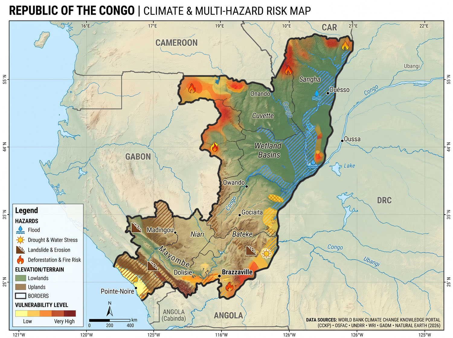
(Prepared by: Z M Sajjadul Islam, Advisor-MHEWC. www.mhewc.org www.glocs.org )
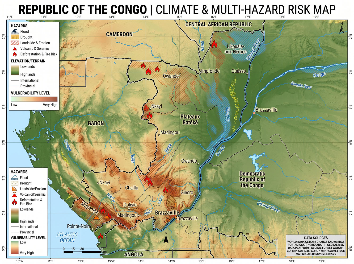
(Prepared by: Z M Sajjadul Islam, Advisor-MHEWC. www.mhewc.org www.glocs.org )
Climate, Multi-hazard, and Disaster Risk Profiles
Country-level assessments | 19 November 2026
São Tomé and Príncipe
Flooding and coastal erosion are the main physical hazards. Homes, roads and essential services cluster along shorelines and river mouths on both islands. Heavy rain and high seas can flood the same communities at once. The mid-2026 INFORM Risk Index scores the country 2.5 out of 10 (Low), with 0.7 for hazard and exposure, 4.0 for vulnerability and 5.3 for lack of coping capacity. INFORM Risk dataset · World Bank district flood assessment
Climate and outlook
- Steep terrain creates sharp rainfall differences. The main rainy season generally runs from September to May, with a short lull around December–January. The cooler, drier gravana typically runs from June to August. Annual rainfall ranges from roughly 1,000 mm in northern São Tomé to 7,000 mm in the southwest. On Príncipe, the national climate assessment reports roughly 2,000 mm in the north and 5,000 mm in the south. National climate communication
- Warming and rising seas increase exposure. São Tomé’s airport station recorded about 0.6°C of warming from 1960 to 2016. The August 2026 national climate submission projects 0.8–1.1°C of warming by mid-century, with more frequent and longer heatwaves. A World Bank coastal assessment cites about 30 cm of sea-level rise by 2050. Local flood depths also depend on tides, waves, river flow and drainage. National climate communication · Updated NDC 3.0 · World Bank flood and coastal assessment
Main hazards and hotspots
| Hazard | Exposure and documented impacts |
|---|---|
| River floods, flash floods and landslides | Key hotspots include São Tomé city and Água Grande, Mé-Zóchi and Lembá on São Tomé, and Santo António on Príncipe. The December 2021 storm caused two reported deaths. Floods and landslides from December 2021 through February 2022 generated an estimated US$37.5 million in recovery needs, about 7% of 2022 GDP. Further flooding damaged homes, farms and roads on Príncipe in May 2022. IFRC final report · National loss and damage assessment |
| Coastal flooding, erosion and rough seas | High tides and waves can coincide with river overflow at exposed sites such as Ribeira Afonso. The World Bank identifies Santa Catarina and Malanza as having particularly high shares of residents exposed to flooding. Shoreline erosion threatens homes, coastal roads and fishing landing sites. Rough seas also put small fishing boats at risk. District flood assessment · Ribeira Afonso assessment · World Bank coastal livelihoods study |
| Dry spells, water shortages and heat | Shortfalls in rainfall and spring flows can interrupt water supply and strain rain-fed farming. In October 2026, the state utility reported depleted spring-fed reservoirs, with shortages affecting communities and São Tomé’s hospital. Flooding poses a separate threat to the same water system through damage and contamination. Utility director’s account via RTP · UNDP water security assessment |
| Disease and geophysical hazards | WHO documented the country’s first reported dengue outbreak in 2022, with about 1,230 confirmed cases and 11 deaths by January 2024. Malaria remains a public health risk. National hazard screening rates tsunami hazard as low and earthquake hazard as very low. The latest dated volcanic activity on São Tomé was about 36,000 years ago. WHO dengue report · WHO malaria profile · ThinkHazard · Smithsonian volcano record |
Vulnerability and disaster risk management
The latest household survey used for the national poverty estimate put 55.5% of people below the national poverty line in 2017. Concentration along coasts and waterways means a single flood can damage housing, cut road access and interrupt water, school and health services. Holding population and assets fixed, the World Bank’s flood model estimates 18,500 people affected in an average year under 2020 climate conditions, rising to 20,500 by 2050 and 23,000 by 2080 under SSP3‑7.0. World Bank Poverty and Equity Brief · World Bank district flood assessment
The national disaster preparedness council and civil protection service coordinate emergency response. The government released its Early Warnings for All roadmap on 5 March 2026 and updated its national climate commitment in August. The WACA+ coastal programme has prepared protection designs for Ribeira Afonso on São Tomé and Chimaló on Príncipe. An October 2026 initiative, RESIslands, is strengthening risk assessment and preparation for climate investment. UNDRR early-warning roadmap · Updated NDC 3.0 · WACA+ project document · UN Economic Commission for Africa
Republic of the Congo (Congo-Brazzaville)
River and urban flooding dominate the disaster record. Repeated floods affect communities along the Congo and Oubangui rivers, while intense rainfall overwhelms drainage and accelerates erosion in Brazzaville and Pointe-Noire. The mid-2026 INFORM Risk Index scores the country 5.6 out of 10 (High), with 4.6 for hazard and exposure, 5.6 for vulnerability and 7.0 for lack of coping capacity. INFORM Risk dataset · IMF flood assessment
Climate and outlook
- The north stays humid through much of the year. The southern part of the country, including Brazzaville and the Atlantic coast, has a more pronounced dry season, generally June–September. National averages were 24.7°C and 1,539 mm of annual rainfall in 1995–2014. WHO country climatology · World Bank Climate Change Knowledge Portal
- Temperatures are rising and annual rainfall projections vary. The World Bank estimates warming of 0.29°C per decade since 1970. Under SSP3‑7.0, models project median warming of 1.26°C in 2040–2059 relative to 1995–2014. Changes in annual rainfall range from −54 to +163 mm across the central 80% of models. The IPCC projects more intense heavy rainfall across Central Africa with high confidence. World Bank climate projections · IPCC regional assessment
Main hazards and hotspots
| Hazard | Exposure and documented impacts |
|---|---|
| River flooding | Likouala, Cuvette, Sangha and Plateaux are exposed to river overflow, and floodwaters can isolate settlements accessible mainly by boat. The joint government–UN assessment of the 2023–2024 floods found 1.79 million people affected and about 525,000 needing emergency assistance. In October 2026, a new flood emergency centred on Épéna, Likouala. UNICEF’s preliminary estimate was about 18,100 affected, including 10,200 children. Government–UN rapid assessment · UNICEF October 2026 update |
| Urban flash flooding, gullies and landslides | In Brazzaville and Pointe-Noire, inadequate drainage and development on vulnerable slopes amplify heavy-rain impacts. Deep gullies can undermine homes and roads. The IFRC estimates that flash floods on 18–19 November 2025 affected about 50,000 people in the two cities. IFRC flood operation · Urban flood and gully study |
| Coastal flooding and erosion | Sea-level rise and shoreline erosion threaten low-lying parts of Pointe-Noire and the Kouilou coast. The Pointe-Noire urban plan identifies the Loango Bay and Pointe-Indienne shorelines as areas for protection. Saltwater intrusion can also affect coastal freshwater supplies. Pointe-Noire urban plan · National disaster risk strategy |
| Heat, dry spells and other hazards | Heat and irregular rainfall threaten rain-fed agriculture and water availability. The national strategy also identifies destructive winds and industrial pollution, including oil spills. National screening rates earthquake and tsunami hazards as low. National disaster risk strategy · ThinkHazard |
| Disease outbreaks | Floods can contaminate drinking water and interrupt access to care. WHO recorded 988 reported cholera cases and 65 deaths from January through 27 September 2026. The country’s October public-health bulletin also tracks mpox and measles. WHO cholera surveillance · WHO country bulletin |
Vulnerability and disaster risk management
Urban concentration and poverty make recovery harder. More than half of the population lives in Brazzaville and Pointe-Noire. The World Bank estimates that 51.2% of people lived below the international US$3-a-day poverty line in 2026, measured in 2021 purchasing-power terms. In northern Likouala, refugees and host communities share limited services in dispersed, flood-prone settlements. Road and river access can become especially difficult during floods. World Bank country overview · October 2026 Poverty and Equity Brief · UNHCR country report
The government received its 2026–2030 national disaster risk strategy in January 2026 and submitted NDC 3.0 in February. On 3 November 2026, it launched preparation of its first National Adaptation Plan and associated investment plan. The World Bank approved US$60 million in 2025 for flood and erosion reduction in Brazzaville and Pointe-Noire. Its climate and development analysis estimates that, under an adverse climate scenario and with limited diversification and climate investment, 2050 GDP could be up to 17% below the model baseline. UNDP strategy announcement · NDC 3.0 · Adaptation plan launch · World Bank urban resilience project · World Bank climate and development assessment
Climate, Multi-hazard and Disaster Risk Profile – Republic of Congo
MHEWC country profile series · Nov 19, 2026 · @Z M Sajjadul Islam
Key messages
Flooding is the Republic of Congo’s dominant hazard: the 2023-24 Congo-Ubangi flood affected about 336,000 people in 9 of the then 12 departments and killed at least 23. Risk is concentrated in two places – the northern river corridor (Likouala, Sangha, Cuvette, Plateaux) and the two cities that hold 58% of the population (Brazzaville and Pointe-Noire).
- River floods are now near-annual. People affected rose from 164,679 (2021) to 222,000 (2022) to about 336,000 (2023-24), with further events in November 2025 (about 50,000 in the two cities) and October 2026 (16,739 in Epena, Likouala).
- Urban flash floods and gully erosion are the fastest-growing risk. Unplanned settlement on sandy, erodible slopes in Brazzaville and Pointe-Noire turns single storms into displacement events; 22,842 people were evacuated in November 2025.
- Epidemics are a co-equal hazard. Mpox (2024-25), chikungunya (2019, 6,149 suspected cases by mid-April) and recurrent cholera in Likouala follow floods, displacement and refugee movements.
- Climate change raises the stakes. The World Bank estimates losses of up to 17% of GDP by 2050 without diversification and adaptation, and climate-related health costs rising from USD 92 million (2010) to USD 260 million (2050).
- Readiness is the binding constraint. ND-GAIN ranks Congo 37th most vulnerable but 187th most ready of 192 countries. A national DRR strategy to 2030 and a recovery strategy for 2025-2030 now exist; operational early warning does not.
- The gap is institutional, not technological. There is no national flood forecasting service, no CAP-based alerting, and no standing mandate linking the Direction de la Meteorologie, hydrological monitoring, the humanitarian ministry and local authorities.
Indicator | Value | Year |
Population (census) | 6.1 million | 2023 |
Share living in Brazzaville + Pointe-Noire | 58.1% | 2023 |
Urban population | about 70% | 2025 |
ND-GAIN rank | 180 of 192 (score 32.8) | 2023 data |
Mean annual rainfall | 1,612 mm | 1991-2020 |
Largest flood (people affected) | about 336,000 | Oct 2023 – Jan 2024 |
Refugees hosted | more than 68,000 | early 2025 |
Projected climate loss without reform | up to 17% of GDP | 2050 |
Country context
Congo is a 342,000 km2 equatorial country of 6.1 million people, among Africa’s most urbanised, with an oil-dependent economy and a sparsely populated forested north. Its exposure is shaped by three geographic units.
Zone | Departments | Main features | Dominant risks |
Northern basin and Cuvette Centrale | Likouala, Sangha, Cuvette, Cuvette-Ouest, Congo-Oubangui, Nkeni-Alima | Flooded forest, peatlands, Ubangi and Sangha rivers; river is the main transport route; refugee-hosting | Slow-onset river floods, cholera, zoonoses (mpox), isolation of communities |
Central plateaux and Pool | Plateaux, Pool, Djoue-Lefini | Savannah and gallery forest along the Congo River; post-conflict Pool | River floods along the Congo, dry spells, bushfires, food insecurity |
South-west and coast | Brazzaville, Pointe-Noire, Kouilou, Niari, Bouenza, Lekoumou | Two main cities, the Congo-Ocean railway corridor, 170 km Atlantic coast, oil and port infrastructure | Urban flash floods, gully erosion, coastal erosion, vector-borne disease, technological accidents |
- Population:1 million at the May 2023 census (RGPH-5), growing 3.2% a year since 2007. Brazzaville holds 2.15 million (34.9%) and Pointe-Noire 1.42 million (23.1%). Tresor
- Administration: 15 departments since the 2024 reform, which split Likouala, Pool and Plateaux. Flood statistics up to 2024 use the former 12-department map, so time series must be re-mapped.
- Economy: oil is about half of GDP and 80% of exports; the country produces only about 30% of its food and imports the rest, so river and road disruption quickly becomes a price shock. WFP
- Poverty and food security: poverty is estimated at 46.6% (2022) and roughly one-third of the population faces food insecurity. GRFC 2024
- Displacement: more than 68,000 refugees from DRC, CAR and Rwanda, mostly in Likouala and Plateaux; new arrivals from DRC into Likouala continued through mid-2026. ACAPS
Climate
Congo has a humid equatorial climate with two rainy seasons; temperatures have risen while total rainfall shows little trend, and the expected change is towards heavier rain events, hotter nights and more variable dry seasons.
Baseline (1991-2020). Monthly mean temperatures range from about 23 C to 26 C, warmest in February-March and coolest in June-August. Mean annual rainfall is 1,612 mm, exceeding 2,000 mm between 1 S and 3 S. Rain falls in March-May and September-November; the dry season lasts 3-4 months in the south and 1-2 months further north. World Bank CCKP
Observed trend. The World Bank reports that mean temperature has increased while precipitation has shown little trend. World Bank Economic Update, 2023 The 2023-24 season showed what the system can produce: WMO linked extreme rainfall from October 2023 to the worst Congo Basin flooding in nearly six decades. Copernicus GloFAS
Variable | Direction of change | Confidence | Main consequence |
Mean and night-time temperature | Increase; about +0.5 C (low emissions) to +4.5 C (high emissions) over the Cuvette Centrale region by 2100 | High | Heat stress in dense urban districts, crop and fish stress, peatland drying |
Annual rainfall | Little change in the mean; larger year-to-year swings | Low to medium | Harder seasonal planning |
Heavy-rain intensity | Increase | Medium | More urban flash floods, gullying, landslides |
Dry-season length and dry spells | More variable, especially in the south | Low to medium | Crop losses in Pool, Bouenza, Niari, Plateaux; bushfires |
Sea level | Rise | High | Coastal erosion and flooding around Pointe-Noire and Loango Bay |
Congo-Ubangi flows | Larger high-flow peaks plausible; record low-water episodes also observed | Low | Floods in the north; navigation and supply disruption |
The temperature range is from IPCC regional projections reported by Carbon Brief via Eco-Business. National downscaled projections (CMIP6, by department) were not located for this profile; producing them is a priority action below.
Hazard profile
Four hazards drive most loss and need most early-warning investment: riverine floods, urban flash floods with gully erosion, epidemics, and coastal erosion. Ratings below are this profile’s assessment from the event record since 2011, on a 1-5 scale.
Hazard | Likelihood (1-5) | Impact (1-5) | Most exposed areas | Season / onset | Evidence |
Riverine flood (Congo, Ubangi, Sangha, Likouala-aux-Herbes) | 5 | 5 | Likouala, Sangha, Cuvette, Plateaux, riverside Brazzaville | Oct-Jan peak; slow onset, weeks of warning possible | 2019, 2021, 2022, 2023-24, 2026 events |
Urban flash flood and gully erosion | 5 | 4 | Brazzaville (Ngamakosso, Ibalico and other hillside districts), Pointe-Noire (Mongo-Mpoukou, Ngoyo) | Oct-May; hours of warning | Nov 2025: about 50,000 affected; ravines up to 100 m deep reported |
Epidemics (cholera, mpox, chikungunya, measles) | 4 | 4 | Likouala and Cuvette (zoonoses, cholera); Kouilou, Pointe-Noire, Brazzaville (arboviruses) | Year-round; often after floods | Chikungunya 2011 and 2019; mpox 2024-25; recurrent cholera in Likouala |
Coastal erosion and marine flooding | 4 | 3 | Pointe-Noire, Loango Bay, Songolo estuary, Kouilou coast | Continuous; worse in swell season | Shoreline retreat and loss of heritage sites reported 2025 |
Landslides and mudflows | 3 | 3 | Steep sandy slopes in Brazzaville and Pointe-Noire | With intense rain | About 190 ha of landslide and mudflow mapped in Brazzaville, Feb 2024 (UNOSAT) |
Dry spells and agricultural drought | 3 | 3 | Pool, Bouenza, Niari, Plateaux, Lekoumou | Jun-Sep dry season, failed onset | Food deficit, 70% of food imported |
Windstorms and lightning | 3 | 2 | Nationwide; river and lake transport | Start and end of rainy seasons | Storm-related boat losses on the shared river system |
Extreme heat | 3 | 2 | Dense districts of the two cities | Feb-Apr | Rising night-time temperatures |
Bush and peat fires | 2 | 2 | Savannahs of Plateaux and Pool; Cuvette Centrale peat in drought years | Dry season | Peatland drying is a projected, not yet observed, risk |
Technological (munitions, oil, industrial) | 2 | 5 | Brazzaville, Pointe-Noire oil and port zone | Sudden | Mpila depot explosion, March 2012 |
Riverine floods. The Brazzaville-Kinshasa gauge measures about 98% of the Congo catchment and gives a long record. In January 2024 levels reached about 6.2 m, near the 1961 record. Floods in the north last weeks, submerge farms and isolate villages reachable only by boat.
Urban floods and erosion. Both cities sit on weakly structured sandy soils. Clearing and unplanned building on slopes and drainage lines turn runoff into ravines that swallow houses, roads and pipes; high rents push poor households onto these plots.
Epidemics. In 2019 chikungunya spread to 8 of 12 departments within three months; the mpox emergency operations centre (COUSP) was activated on 3 May 2024. Flood displacement and refugee settlement in Likouala raise cholera risk.
Coastal hazards. Shoreline retreat around Pointe-Noire and Loango Bay is driven by both natural dynamics and port and coastal works; sacred sites and fishing grounds are being lost.
Disaster history, 2011-2026
Since 2019 a significant flood has struck in every year; the event table below is newest first. Figures are the most consolidated official or Red Cross numbers found; early estimates often differ.
Date | Event | Areas | Impact | Source |
Jun 2026 onward | Refugee influx from DRC | Betou, Enyelle (Likouala) | New waves since Dec 2025; cholera risk flagged | |
Oct 2026 | River flood | Epena sub-prefecture, Likouala | 16,739 people in 2,738 households; 11 of 22 villages flooded; helicopters deployed | |
18-19 Nov 2025 | Urban flash flood | Brazzaville, Pointe-Noire | About 50,000 affected, 22,842 evacuated, 55 injured; thousands of houses damaged | |
2024-25 | Mpox outbreak | Cuvette, Likouala, Plateaux, Pointe-Noire, Brazzaville | 212 suspected and 22 confirmed by Oct 2024; cases continued into 2025 | |
Oct 2023 – Jan 2024 | Congo-Ubangi flood, state of emergency 29 Dec 2023 | 9 of 12 departments; worst in Likouala, Sangha, Cuvette, Plateaux, Niari, Brazzaville, Pointe-Noire | About 336,560 affected, 23 dead, 6,178 displaced; 26 health facilities and 120 schools damaged; 361 villages submerged | |
Nov-Dec 2022 | River flood | Likouala, Sangha, Cuvette, Plateaux | 164,679 affected (IFRC DREF); 3,985 houses in Likouala damaged or destroyed | |
2021 | River flood | Cuvette, Plateaux, Likouala, Sangha | Reported in IFRC records as 164,679 (2021) and 222,000 (2022) affected | |
2019-2021 | Repeated floods | Northern departments | About 5% of the population affected over three years | |
Jan-Apr 2019 | Chikungunya | 8 of 12 departments, 47% of cases in Kouilou | 6,149 suspected cases by 14 April, no deaths | |
4 Mar 2012 | Mpila munitions depot explosion | Brazzaville (Ouenze, Talangai) | About 150-200+ dead, more than 2,300 injured, about 14,000 homeless | |
2011 | Chikungunya | Brazzaville (91%), Pool | 11,083 cases |
Note on the 2022 and 2021 rows: IFRC documents give 164,679 for the flood response launched in January 2023 but also cite it as the 2021 figure. The series needs reconciliation against the humanitarian ministry’s own records. Early 2024 estimates of 1.8 million affected (government and Red Cross, 19 January) were later consolidated to about 336,000.
Exposure and vulnerability
Congo’s exposure is concentrated (two cities, one river corridor) and its vulnerability is driven by poverty, informal housing, dependence on imported food and weak service reach in the north.
Factor | What it means for disaster risk | Evidence |
Urban concentration | 3.5 million people in two cities; growth outpaces drainage, roads and land-use control | 58.1% of population in Brazzaville and Pointe-Noire (2023) |
Informal settlement on hazardous land | Households build on slopes, ravine edges and drainage lines because rents are high | Ngamakosso, Ibalico (Brazzaville); Mongo-Mpoukou, Ngoyo (Pointe-Noire) |
River-dependent north | Villages reachable only by water; floods cut supply, health access and schooling for weeks | 361 villages submerged in 2023-24 |
Refugee and host communities | Large displaced population in flood-prone Likouala and Plateaux, with thin WASH coverage | More than 68,000 refugees (early 2025) |
Food-system dependence | About 70% of food imported; local harvest losses and transport cuts raise prices fast | About 1.9 million people (31%) food insecure at the Oct-Nov 2023 peak |
Poverty and limited savings | Little household capacity to recover; losses become debt or distress sales | Poverty about 46.6% (2022) |
Health system reach | Outbreaks under-detected; surveillance strained in floods | WHO noted limited detection capacity during the 2019 chikungunya outbreak |
Indigenous and forest communities | Remote, under-served, often missing from registers and warning channels | Likouala, Sangha, Lekoumou |
Ecosystem dependence | Peatlands of the Cuvette Centrale (about 145,500 km2 shared with DRC) store about 30 billion tonnes of carbon and regulate floods | Drying would release carbon and alter flood regimes |
Groups at highest risk: children and pregnant women in flooded northern villages; refugees and asylum seekers in Likouala and Plateaux; households in ravine-edge districts of the two cities; persons with disabilities and older people with no evacuation support; and women heads of household, who faced overcrowding, loss of privacy and higher GBV risk in November 2025 shelters (IFRC).
Risk governance
Congo now has the strategy layer – a DRR strategy to 2030 and a post-disaster recovery strategy for 2025-2030 – but not yet the operating layer: a lead agency with budget, a legal warning mandate, and local-level plans.
Institutions
Function | Lead institution | Current role | Gap |
Humanitarian response and recovery | Ministry of Social Affairs, Solidarity and Humanitarian Action | Damage and needs figures; relief; holder of the 2025-2030 recovery strategy | No permanent DRM agency; response led ad hoc by task forces under the Prime Minister |
DRR policy and climate | Ministry of Environment, Sustainable Development and the Congo Basin | DRR strategy (2021, update to 2030); NDC; UNFCCC focal point | Strategy not yet tied to sector budgets |
Civil protection | Directorate of civil security (sécurité civile), Ministry of Interior | First response, rescue | Limited presence outside main towns |
Weather and climate services | Direction de la Météorologie, within ANAC (civil aviation agency) | Aviation weather, forecasts, bulletins | Housed in an aviation body; thin surface network; no impact-based warnings |
Hydrology | Hydrological services and CICOS (regional, Kinshasa) | Brazzaville-Kinshasa gauge, navigation forecasts, hydrological information system | No national flood forecasting or warning mandate |
Health emergencies | Ministry of Health, COUSP (emergency operations centre) | Outbreak response; activated for mpox in May 2024 | Surveillance and lab capacity concentrated in Brazzaville |
Urban risk | Ministry of Territorial Development and Major Works; Ministry of Construction, Urbanism and Habitat | Executing the World Bank urban resilience project | Weak land-use enforcement; slow decentralisation |
Community level | Congolese Red Cross (13,000 volunteers in all departments), Caritas, local authorities | Assessments, relief, community awareness | Volunteer networks not formally linked to warnings |
Policy and plans
- National DRR Strategy and Action Plan 2022-2026, handed over in December 2021 with UNDP support and Japanese funding; it maps risks and assigns responsibilities. UNDP
- National Strategy for Prevention and Management of Disaster Risks (SNPGRC) to 2030, presented January 2026, costed at 22.8 billion CFA francs and resting on a national DRR platform. AllAfrica
- National Post-Disaster Recovery Strategy 2025-2030 with reconstruction action plan, developed over 24 months with UNDP. UNDP
- Updated NDC (August 2021): 17.09% unconditional and 39.88% conditional emissions cuts against business-as-usual by 2025; adaptation priorities in agriculture, forestry, water, health, coastal zone and tourism. UNDP Climate Promise
- National Adaptation Plan: no submitted NAP was located in this review – verify with the Ministry of Environment.
Financing
Instrument | Amount | Status | Relevance |
World Bank Strengthening Urban Resilience Project (P179190), plus GEF-8 grant | USD 60 million + USD 6.47 million | Approved Oct 2025, under implementation | Flood and erosion works in Brazzaville and Pointe-Noire; about 575,000 beneficiaries |
SNPGRC to 2030 | 22.8 billion CFA francs | Strategy cost; financing plan not published | Whole DRR system |
CREWS Central Africa (WMO, UNDRR, World Bank) | Regional | Ongoing | Flood forecasting (FANFAR extension), CAP, regional coordination |
Kolendissa community flood resilience (US, CRS, Caritas, Red Cross) | Not published | Launched Dec 2024; status after 2025 US aid cuts unclear | Early warning and community flood management in the north |
Humanitarian (IFRC DREF, CERF, UN agencies) | about CHF 0.5 million per DREF | Event-by-event | Response only; no pre-arranged trigger financing |
There is no national disaster fund, contingency credit line, sovereign risk insurance or forecast-based financing protocol on record. Every event is financed after the fact.
Early warning system: four-pillar assessment
Congo has the raw ingredients for river-flood warning – a century-long gauge record at Brazzaville, slow-onset floods, a national Red Cross network – but no end-to-end chain from forecast to household action. Ratings are this profile’s assessment (1 = absent, 5 = fully functional).
Pillar | Rating | What exists | Main gaps |
1. Risk knowledge | 2 | 2021 DRR strategy risk mapping; UNOSAT flood and landslide maps (2023-24); World Bank CCDR; urban flood studies for P179190 | No national multi-hazard risk atlas; no harmonised loss database (figures conflict across sources); flood history not re-mapped to the 15 departments; no downscaled climate projections |
2. Monitoring and forecasting | 2 | Direction de la Météorologie (ANAC); Brazzaville-Kinshasa gauge; CICOS hydrological information system; CREWS Central Africa extending FANFAR flood forecasting; global products (GloFAS, satellite rainfall) | Sparse surface stations and gauges in the north; no national hydrological forecasting unit; no flash-flood guidance for the two cities; health surveillance separate from hydromet data |
3. Warning dissemination and communication | 1-2 | Radio and TV bulletins; government statements; Red Cross and church networks; mobile coverage in towns | No Common Alerting Protocol (CAP) feed; no cell broadcast or SMS alerting; no warning in Lingala, Kituba or local languages as standard; river villages reached late or not at all |
4. Preparedness and response capability | 2 | Ad hoc task forces; COUSP for epidemics; Red Cross DREF responses; recovery strategy 2025-2030 | No national contingency plan with triggers; no pre-positioned stocks in Likouala; no anticipatory-action or forecast-based financing protocol; evacuation sites not designated in ravine districts |
Who should hold the alert decision. A workable division: the Direction de la Météorologie issues weather warnings; a designated hydrological unit issues river-flood forecasts; the humanitarian ministry (or a future DRM agency) validates and issues public alerts with impact statements; the Ministry of Health issues health alerts; prefects and mayors activate local plans. This needs a decree, a standard operating procedure and a joint duty roster.
Regional anchors. CREWS Central Africa, the ECCAS situation room and AMHEWAS are building regional flood forecasting and CAP capacity, and Congo already participates in CREWS workshops. Brazzaville and Kinshasa share the same river and gauge: a joint Brazzaville-Kinshasa warning protocol is the cheapest high-impact step available.
Congo does not appear among countries with a launched national EW4ALL roadmap; neighbouring DRC launched its own in January 2026. UNDRR
Priority actions and roadmap
The first 12 months should deliver a working river-flood warning for the north and a flash-flood alert for the two cities, built on existing institutions and the funded urban resilience project. Costs are indicative planning ranges for discussion, not estimates from source documents.
# | Action | Lead | Partners | Timing | Indicative cost (USD) | Success indicator |
1 | Decree assigning warning mandates (weather, river flood, health, public alert) and a joint SOP | Prime Minister’s office | Humanitarian, Environment, Health ministries; ANAC | 0-6 months | 50k-100k | Decree signed; SOP tested in a simulation |
2 | Launch an EW4ALL national roadmap and multi-hazard EWS coordination committee | Ministry of Environment with humanitarian ministry | UNDRR, WMO, ITU, IFRC | 0-6 months | 100k-200k | Roadmap validated; committee meets monthly in season |
3 | Operational river-flood forecasting for Congo, Ubangi and Sangha, with Brazzaville-Kinshasa data sharing | Hydrological unit + Direction de la Météorologie | CICOS, CREWS (FANFAR), AGRHYMET, SMHI, DRC services | 3-18 months | 1.5-3 million | 10-day flood outlooks issued each season; lead time of at least 5 days for Likouala villages |
4 | Restore and add gauges and rain stations in Likouala, Sangha, Cuvette, Plateaux; telemetry to Brazzaville | Direction de la Météorologie | World Bank, WMO SOFF | 6-24 months | 2-4 million | Data reach the forecast desk in real time |
5 | Flash-flood and erosion alerts for Brazzaville and Pointe-Noire, linked to P179190 drainage works | Municipalities, MATGT | World Bank, Direction de la Météorologie | 6-18 months | 0.5-1 million | Rainfall thresholds set per catchment; evacuation sites designated in ravine districts |
6 | CAP alert hub and multi-channel dissemination: cell broadcast/SMS, community and AM/FM radio, Red Cross volunteers, church networks; Lingala and Kituba messages | Humanitarian ministry; telecom regulator (ARPCE) | Mobile operators, ITU, IFRC | 6-24 months | 0.8-1.5 million | Every alert published in CAP and reaches 80% of an at-risk district within 2 hours |
7 | National multi-hazard risk atlas and loss database re-mapped to 15 departments; downscaled CMIP6 projections | INS + Ministry of Environment | Universities, UNDP, World Bank | 6-24 months | 0.5-1 million | Public atlas online; single official loss series from 2019 |
8 | Anticipatory action protocol and pre-arranged finance for northern floods and cholera | Humanitarian ministry; Ministry of Finance | WFP, UNICEF, OCHA (CERF), IFRC | 12-24 months | 1-2 million in trigger funds | Protocol activated before peak flood at least once |
9 | Pre-positioned stocks and boats in Impfondo, Ouesso, Owando, Mossaka | Humanitarian ministry | WFP, Red Cross | 6-12 months | 0.5-1 million | Stocks in place by 1 October each year |
10 | Integrate health surveillance with flood alerts (cholera, malaria after floods) | Ministry of Health, COUSP | WHO, UNICEF | 6-18 months | 0.3-0.6 million | Health alert issued within 7 days of each flood alert |
11 | Coastal monitoring and setback rules for Pointe-Noire and Loango Bay | Ministry of Environment; Port authority | Universities, AfDB | 12-36 months | 0.5-1.5 million | Shoreline monitored yearly; setback line adopted |
Sequencing. Actions 1-2 unlock everything else and cost little. Actions 3, 5 and 6 deliver visible warnings within two flood seasons. Actions 7, 8 and 11 make the system durable and fundable.
Financing angle. Total indicative cost for the first three years is about USD 8-17 million – small next to the USD 60 million urban project and the 22.8 billion CFA franc DRR strategy. The case to partners is to fund the warning layer that protects those investments.
Data gaps, caveats and sources
Open questions to resolve with national counterparts
- ☐ Official loss and damage series 2019-2026 from the humanitarian ministry (sources disagree on 2021-2022 and early 2024 figures).
- ☐ Number and status of operational synoptic, rain and river stations, by department.
- ☐ Whether a National Adaptation Plan has been drafted or submitted.
- ☐ Legal basis and membership of the national DRR platform under the 2030 strategy.
- ☐ Status of the Kolendissa project after the 2025 changes in US foreign assistance.
- ☐ INFORM Risk 2026 scores for Congo (not retrieved for this profile).
Caveats. Hazard and pillar ratings are this profile’s expert assessment, not an official index. Indicative costs are planning ranges. Department names follow the 2024 15-department structure except where a source uses the older map.
Sources
- World Bank Climate Change Knowledge Portal, Congo current climate
- World Bank, Republic of Congo CCDR press release, Oct 2023
- World Bank, Strengthening Urban Resilience Project approval, Oct 2025
- GEF, Project 11307
- ND-GAIN, Congo country page
- OCHA, Republic of Congo Assistance Overview, Oct 2024
- ACAPS, Briefing note: flooding, 22 Jan 2024 and country page
- IFRC DREF reports MDRCG020, MDRCG022, MDRCG026, MDRCG029
- ReliefWeb, Congo: Floods – Nov 2025
- UNOSAT, Brazzaville flood and landslide analysis, Feb 2024
- WHO, Chikungunya – Congo, 1 May 2019; WHO AFRO mpox situation reports
- UNDP, DRR strategy handover, Dec 2021 and post-disaster recovery strategy, Jun 2026
- AllAfrica, SNPGRC to 2030, Jan 2026 and urban erosion, Aug 2026
- WMO, Central Africa early warning collaboration; CREWS, Central Africa project
- WMO Members, Congo NMS profile
- Mongabay, Coastal erosion in West and Central Africa, Dec 2025
- Tresor, Recensement 2023 au Congo-Brazzaville
- FSIN, GRFC 2024 country brief; WFP country briefs 2025
- ISS, Mpila munitions depot explosion