Barbados: Climate, Multi-Hazard and Disaster Risk and Vulnerability Profile
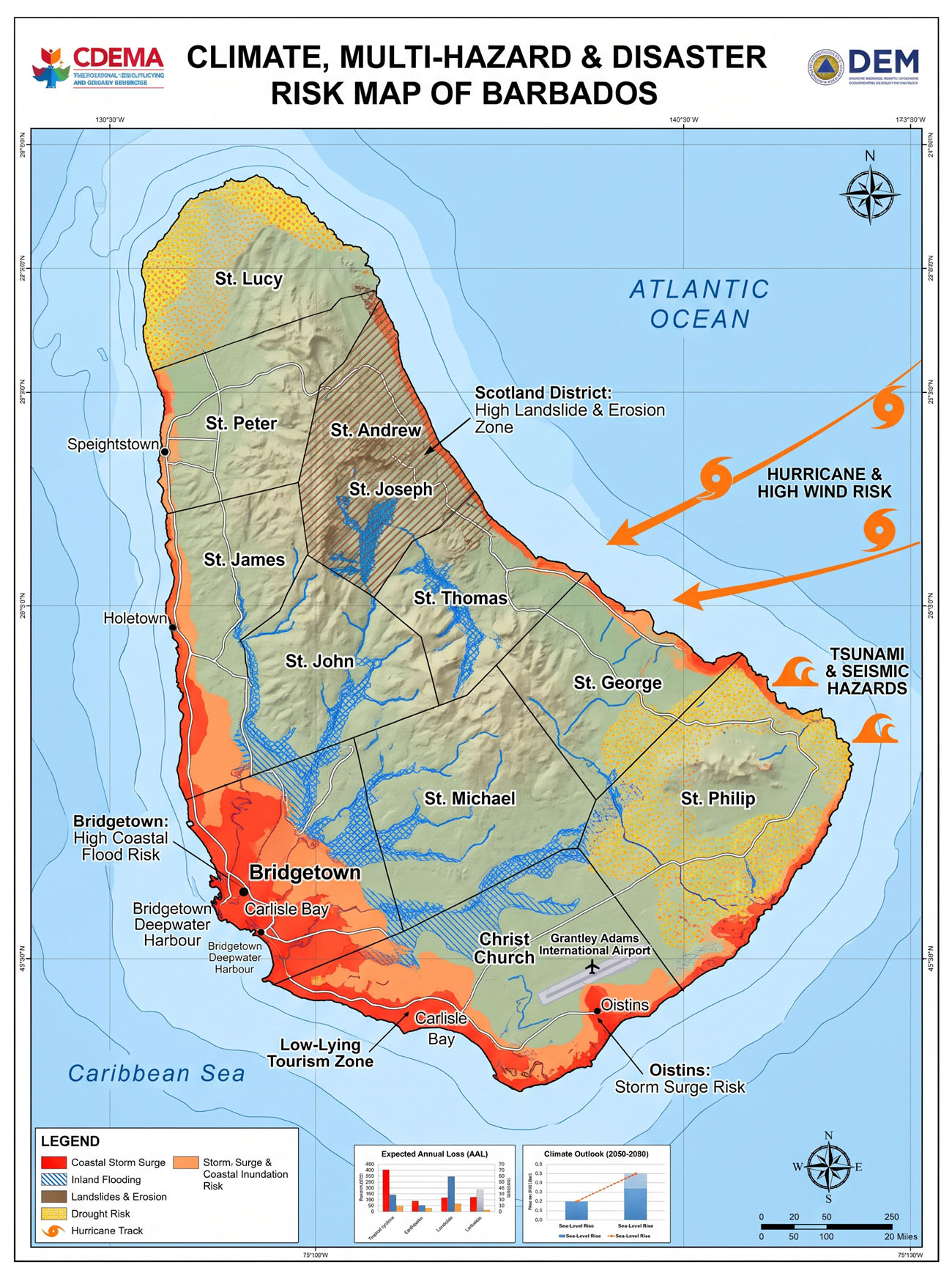
Barbados is a Small Island Developing State (SIDS) with high exposure to climate and disaster risk because of its small land area, dense population, concentration of settlements and economic assets near the coast, dependence on tourism and imported resources, water scarcity, ageing infrastructure, and exposure to Atlantic tropical systems. Its 2025 Second Nationally Determined Contribution (NDC) identifies sea-level rise, storm surge, tropical cyclones, flooding, drought, water scarcity, marine heatwaves and related coastal impacts as central climate risks. UNFCCC
The risk environment is broader than climate hazards alone. Barbados’ Department of Emergency Management identifies hurricanes, flooding, storm surge, landslides, earthquakes and tsunamis among the principal natural hazards, alongside biological, technological and anthropogenic threats. Government of Barbados
1. Climate and environmental context
Barbados has a tropical, dry sub-humid climate, with temperatures generally around 24°C to 28°C, a relatively dry season from December to May and a wetter season from June to November. Unlike many larger Caribbean islands, Barbados has no permanent rivers, making groundwater particularly important for national water security. CDEMA
Climate change is altering this baseline through:
- rising air and sea temperatures;
- changing and increasingly variable rainfall;
- more severe drought conditions;
- heavier extreme rainfall events;
- higher sea levels;
- stronger coastal inundation and storm surge;
- marine heatwaves;
- ecosystem degradation;
- saltwater intrusion into freshwater resources; and
- potentially more damaging high-intensity tropical cyclones.
Barbados’ 2025 NDC indicates that the country could experience a 15-30% climate-related reduction in rainfall, an especially serious concern because Barbados already has less than 284 m³ of renewable freshwater per person per year. UNFCCC
The World Bank describes Barbados as one of the world’s most water-scarce countries. Approximately 86% of potable water comes from groundwater, while groundwater abstraction is already close to sustainable yield. Water demand is projected to increase substantially toward 2050. World Bank
2. Principal climate and multi-hazard risks
| Hazard | Main areas/assets at risk | Principal consequences |
|---|---|---|
| Tropical storms and hurricanes | Entire island, especially coast, housing, utilities, tourism, fisheries | Wind damage, roof failure, power outages, flooding, storm surge, coastal damage |
| Storm surge and coastal inundation | South and west coastal corridors, Bridgetown, ports, tourism areas | Infrastructure damage, coastal flooding, beach loss, business interruption |
| Sea-level rise | Low-lying coastal settlements and infrastructure | Permanent inundation, erosion, saline intrusion, higher storm-surge baseline |
| Coastal erosion | Beaches, tourism zones, coastal roads and settlements | Loss of land, tourism assets and natural coastal protection |
| Flooding / flash flooding | Urban areas, depressions, drainage corridors | Property damage, transport disruption, water contamination |
| Drought | Island-wide, especially agriculture and water supply | Water shortages, crop losses, food insecurity, groundwater stress |
| Extreme heat | Urban population, outdoor workers, vulnerable groups | Heat stress, health impacts, energy demand, productivity loss |
| Marine heatwaves | Coral reefs, fisheries, marine ecosystems | Coral bleaching, ecological degradation, fisheries and tourism impacts |
| Sargassum influx | Eastern and southern coastal areas | Tourism disruption, fisheries impacts, health and waste-management burden |
| Landslides / land slippage | Steeper central and upland areas | Road damage, structural impacts and local isolation |
| Earthquakes | Entire island | Structural damage, utility disruption and potential tsunami generation |
| Tsunamis | Low-lying coastal areas | Rapid coastal inundation, casualties and infrastructure destruction |
| Volcanic ashfall | Island-wide depending on wind direction | Health, agriculture, aviation, water and infrastructure disruption |
| Biological hazards | Population and public-health system | Vector-, water- and food-borne diseases, epidemics |
| Technological hazards | Ports, industry, utilities, digital systems | Oil/chemical spills, cyber incidents and cascading infrastructure failures |
Barbados’ official disaster-risk documentation specifically recognises floods, droughts, tropical systems, earthquakes, landslides and tsunamis in its historical hazard profile. Government of Barbados
3. Tropical cyclone and hurricane risk
Although Barbados lies toward the southeastern margin of the main Atlantic hurricane belt and historically experiences fewer direct hurricane landfalls than some northern Caribbean islands, this should not be interpreted as low risk.
Large tropical cyclones can produce damaging:
- hurricane-force winds;
- extreme waves;
- storm surge;
- coastal inundation;
- heavy rainfall;
- flash flooding;
- erosion; and
- disruption of electricity, telecommunications, transport and water supplies,
even when the storm centre does not pass directly over Barbados. Barbados’ 2025 NDC specifically notes this exposure. UNFCCC
Since 2010, systems affecting Barbados have included Tomas (2010), Ernesto (2012), Harvey (2017), Elsa (2021), Gonzalo (2020) and Beryl (2024), among others. UNFCCC
Hurricane Beryl – 2024
Hurricane Beryl passed approximately 150 km from Barbados in June-July 2024 but nevertheless caused substantial damage, particularly to fisheries, coastal and port infrastructure and tourism-related assets. The World Bank estimates damage equivalent to approximately 1.4% of GDP. World Bank
This illustrates an important feature of Barbados’ risk profile: a cyclone does not need to make direct landfall to generate significant national economic loss.
4. Sea-level rise, coastal erosion and storm surge
Coastal risk is among Barbados’ most serious long-term challenges.
A large share of:
- population;
- tourism accommodation;
- commercial development;
- roads;
- electricity infrastructure;
- telecommunications;
- ports;
- fisheries facilities;
- wastewater infrastructure; and
- cultural and recreational assets
is concentrated close to the coastline.
Barbados’ NDC identifies sea-level rise, storm surge and increasingly severe maritime conditions as dominant elements of its climate-risk profile. UNFCCC
Sea-level rise compounds other hazards by:
Sea-level rise → higher baseline water level → stronger storm-surge penetration → coastal flooding → erosion → infrastructure damage → saline intrusion.
World Bank projections show continuing sea-level rise around Barbados under all assessed emissions pathways, increasing the frequency and severity of coastal inundation and high-tide flooding. Climate Knowledge Portal
Highly vulnerable coastal assets
Particularly vulnerable assets include:
- Bridgetown and its waterfront;
- Bridgetown Port;
- fisheries landing facilities;
- south- and west-coast tourism corridors;
- beaches and coastal recreational areas;
- hotels and restaurants;
- coastal roads;
- wastewater facilities;
- electricity and telecommunications infrastructure; and
- low-lying residential areas.
5. Flood risk
Flooding remains one of Barbados’ recurrent hazards.
Flood risk results from the interaction of:
- intense tropical rainfall;
- short-duration convective storms;
- impermeable urban surfaces;
- limited drainage capacity;
- blocked drains;
- low-lying topography;
- inadequate stormwater storage;
- coastal backwater effects; and
- increasingly intense precipitation events.
Barbados’ historical disaster records identify flooding as one of the country’s most frequently recorded hazards. Government of Barbados
Urban vulnerability
Greater Bridgetown and other developed coastal areas are particularly vulnerable because dense development reduces infiltration and concentrates runoff into drainage networks.
Flooding can simultaneously disrupt:
- roads;
- homes;
- businesses;
- electricity;
- telecommunications;
- schools;
- health services;
- sanitation;
- drinking-water quality; and
- tourism activities.
This creates a potentially significant urban cascading-risk problem.
6. Drought and water-security risk
Water security may be Barbados’ most strategically important climate vulnerability.
Barbados’ 2025 NDC explicitly characterises water security as the most severe medium- to long-term threat to the population and economy. UNFCCC
The problem results from the combination of:
- naturally limited freshwater resources;
- heavy dependence on groundwater;
- decreasing or increasingly variable rainfall;
- prolonged drought;
- high population density;
- tourism demand;
- agricultural demand;
- ageing distribution infrastructure;
- groundwater pollution;
- saltwater intrusion; and
- increased evapotranspiration under warmer temperatures.
Recent drought episodes have produced rainfall deficits of around 35-40% below long-term averages, while future changes could further reduce groundwater recharge. World Bank
Compound water risk
A significant concern is the combination:
Drought → lower aquifer recharge → greater groundwater abstraction → saline intrusion → reduced potable supply → higher treatment/desalination costs.
At the opposite extreme:
Intense rainfall → flooding → pollutant infiltration → groundwater contamination → reduced drinking-water quality.
Thus, both too little and too much rainfall can threaten Barbados’ water security.
7. Agricultural and food-security vulnerability
Agriculture is vulnerable to:
- drought;
- heat stress;
- rainfall variability;
- flooding;
- wind damage;
- saltwater intrusion;
- soil degradation;
- pests and diseases;
- invasive species;
- water shortages; and
- extreme storm events.
Barbados’ NDC identifies drought, flooding, storm damage, pest outbreaks, invasive species and saline intrusion as important threats to agricultural production and incomes. UNFCCC
The country’s limited land area and dependence on food imports add another systemic vulnerability. Major external climate or supply-chain shocks can increase:
- food prices;
- import costs;
- shortages;
- nutrition vulnerability; and
- foreign-exchange pressure.
Agricultural resilience therefore needs to integrate water security, irrigation, soil management, climate services, crop diversification, protected agriculture and agricultural risk financing.
8. Fisheries and marine-resource vulnerability
Fisheries are particularly exposed because fishing vessels, landing sites, markets and related infrastructure are concentrated along the coast.
Major threats include:
- hurricanes;
- extreme waves;
- storm surge;
- ocean warming;
- marine heatwaves;
- coral degradation;
- changes in fish distribution;
- sargassum;
- coastal infrastructure destruction; and
- ocean ecosystem change.
Hurricane Beryl demonstrated this vulnerability in 2024 through major impacts on Barbados’ fishing fleet and fisheries infrastructure. World Bank
9. Tourism vulnerability
Tourism is simultaneously one of Barbados’ most important economic sectors and one of its most climate-exposed.
The country’s 2025 NDC reports that tourism directly contributed around 17.5% of GDP in 2024, while estimates incorporating indirect effects are considerably higher. UNFCCC
Tourism depends heavily on:
- beaches;
- coral reefs;
- coastal scenery;
- reliable freshwater;
- electricity;
- airports and ports;
- safe transport;
- functioning telecommunications; and
- favourable climatic conditions.
Therefore climate risks affect the sector through:
Sea-level rise + coastal erosion + stronger storms + coral degradation + water scarcity + heat + sargassum.
Loss of beaches and coral reefs is therefore not merely an environmental issue – it constitutes a national macroeconomic risk.
10. Human settlements and housing vulnerability
Barbados’ housing and settlement vulnerability reflects:
- concentration of development near the coast;
- ageing housing stock;
- variable building resilience;
- exposure to hurricane winds;
- drainage limitations;
- coastal flooding;
- heat exposure; and
- high infrastructure density.
The national NDC specifically identifies ageing infrastructure and housing stock, high population density and past patterns of development among factors increasing climate vulnerability. UNFCCC
Lower-income communities can face greater recovery constraints because households may have:
- fewer financial reserves;
- weaker insurance coverage;
- less resilient housing;
- reduced access to credit; and
- greater difficulty financing repairs or relocation.
Barbados’ NDC specifically highlights lower-income communities, women and youth as groups that may experience disproportionate climate impacts. UNFCCC
11. Public-health vulnerability
Climate change creates both direct and indirect health risks.
Principal concerns include:
- heat stress;
- vector-borne diseases;
- waterborne diseases;
- reduced water quality;
- food insecurity;
- post-disaster injuries;
- respiratory effects;
- disruption of health facilities;
- interruption of pharmaceutical refrigeration;
- sanitation failure; and
- psychological effects associated with disasters and displacement.
Barbados’ NDC identifies increased heat stress and water- and vector-borne diseases among climate-sensitive health impacts. UNFCCC
Hurricanes can also create cascading healthcare failures through simultaneous disruption of:
electricity + water + sanitation + telecommunications + cold-chain systems + transport access.
12. Coral reefs, beaches and ecosystem vulnerability
Coral reefs, seagrasses, beaches and other coastal ecosystems constitute important natural infrastructure.
They support:
- fisheries;
- tourism;
- biodiversity;
- coastal protection;
- sediment stability;
- recreation; and
- livelihoods.
Major pressures include:
- ocean warming;
- marine heatwaves;
- coral bleaching;
- sea-level rise;
- sediment and nutrient pollution;
- storm damage;
- coastal development;
- sargassum; and
- ecosystem degradation.
Degradation reduces natural protection from waves and storm surge, creating an important feedback loop:
coral/reef degradation → reduced wave attenuation → greater coastal erosion and flooding → further ecosystem and infrastructure damage.
Barbados’ Roofs to Reefs Programme explicitly includes restoration of vulnerable coral ecosystems, particularly along the west and south coasts. UNFCCC
13. Extreme heat
Rising temperature is an emerging national risk.
Key exposed groups and systems include:
- elderly people;
- children;
- outdoor workers;
- construction workers;
- agricultural workers;
- people with existing health conditions;
- poorly ventilated housing;
- schools;
- tourism workers; and
- electricity infrastructure.
Increasing temperatures can also increase:
- cooling demand;
- electricity consumption;
- water consumption;
- occupational heat stress;
- food spoilage; and
- vector-borne disease suitability.
Heat therefore interacts with both energy security and water security.
14. Landslide and land-slippage risk
Although Barbados is less mountainous than many Caribbean states, landslides and land slippage remain recognised national hazards, particularly in areas of unstable geology and steeper terrain.
Risk increases under:
- prolonged heavy rainfall;
- saturated soils;
- poor drainage;
- vegetation removal;
- excavation; and
- poorly controlled development.
The Department of Emergency Management includes land slippage among hazards requiring national preparedness. Government of Barbados
15. Earthquake risk
Barbados lies within the seismically active eastern Caribbean environment.
Earthquakes can cause:
- structural damage;
- utility failure;
- road damage;
- port disruption;
- communications disruption;
- injuries and fatalities; and
- secondary tsunami hazards.
Although earthquakes are not climate-driven, they must be incorporated within Barbados’ national multi-hazard risk-management framework. Government of Barbados
16. Tsunami risk
Barbados has genuine tsunami exposure.
Potential tsunami sources include:
- regional submarine earthquakes;
- underwater volcanic eruptions;
- submarine landslides; and
- distant Atlantic tsunami-generating events.
Barbados’ Department of Emergency Management confirms that known tsunami-generating sources exist within the wider regional environment and that shallow earthquakes represent an important tsunami-generating mechanism. Government of Barbados
Low-lying coastal areas, ports, tourism facilities and coastal settlements would face the greatest exposure.
17. Volcanic ash and transboundary volcanic risk
Barbados itself has no active volcano, but it is exposed to transboundary volcanic hazards from neighbouring Caribbean islands.
The 2021 eruption of La Soufrière in Saint Vincent and the Grenadines caused extensive ashfall in Barbados, affecting:
- air quality;
- health;
- agriculture;
- water supplies;
- aviation;
- transportation;
- businesses; and
- infrastructure.
Barbados’ NDC describes the volcanic ash crisis as one of three recent overlapping crises alongside COVID-19 and climate impacts. UNFCCC
The Department of Emergency Management also recognises volcanic ash from neighbouring states as a relevant national hazard. Government of Barbados
This demonstrates the importance of incorporating transboundary hazards into national multi-hazard planning.
18. Critical infrastructure vulnerability
Critical infrastructure at risk includes:
Water
- groundwater wells;
- pumping stations;
- pipelines;
- reservoirs;
- wastewater treatment facilities.
Energy
- electricity generation;
- transmission;
- distribution;
- fuel storage;
- renewable-energy systems.
Transport
- roads;
- bridges;
- Bridgetown Port;
- Grantley Adams International Airport;
- fisheries ports and landing sites.
ICT
- mobile telecommunications;
- internet infrastructure;
- broadcasting;
- emergency communication networks.
Social infrastructure
- hospitals;
- health centres;
- schools;
- emergency shelters;
- police and emergency facilities.
Because Barbados is geographically small, a single major event can affect multiple infrastructure systems simultaneously.
19. Socio-economic vulnerability
Barbados’ vulnerability is amplified by several structural characteristics:
High population density
The 2025 NDC reports a population density exceeding 600 people/km², resulting in strong competition for land and resources. UNFCCC
Coastal concentration
People, infrastructure and economic activity are heavily concentrated near vulnerable coastlines.
Tourism dependence
A major cyclone or coastal disaster can simultaneously reduce:
- employment;
- government revenue;
- foreign exchange;
- business income; and
- GDP.
Import dependence
Dependence on imported:
- food;
- fuel;
- construction materials;
- machinery; and
- other commodities
creates vulnerability to external climate and supply-chain shocks.
Limited fiscal space
Major disasters can produce exceptionally high losses relative to the size of Barbados’ economy, increasing public debt and reconstruction expenditure.
This is why Barbados has invested in disaster-risk financing instruments including catastrophe financing and disaster-related debt clauses. World Bank
20. Geographic concentration of vulnerability
South and west coastal corridors
Particularly exposed to:
- sea-level rise;
- coastal erosion;
- storm surge;
- tourism disruption;
- coastal flooding; and
- marine ecosystem degradation.
Greater Bridgetown
High concentration of:
- population;
- businesses;
- government functions;
- transport;
- port assets;
- drainage infrastructure; and
- critical services
creates potentially high cascading risk.
Eastern coastline
Exposed to:
- Atlantic wave action;
- coastal erosion;
- tropical cyclone effects;
- sargassum;
- cliff instability in some locations.
Central and upland areas
More relevant for:
- land slippage;
- intense-rainfall runoff;
- groundwater recharge; and
- agricultural vulnerability.
Island-wide groundwater system
Climate-related drought, contamination and saline intrusion make groundwater vulnerability effectively a national-scale issue rather than a local hazard.
21. Climate-vulnerable sectors
The most climate-vulnerable sectors can therefore be grouped as:
- Water resources and water supply
- Coastal zone and marine resources
- Tourism
- Agriculture and food security
- Fisheries
- Housing and human settlements
- Health
- Transport and critical infrastructure
- Energy
- Wastewater and sanitation
- Biodiversity and ecosystems
- Financial services and insurance
- Social protection and livelihoods
The 2025 NDC explicitly identifies agriculture, water resources, health and settlements, coastal resources, fisheries and insurance, with tourism receiving particular attention because of its dependence on low-lying coastal resources. UNFCCC
22. Barbados’ principal compound and cascading risks
For Barbados, disaster planning should move beyond treating hazards separately.
Cyclone cascade
Hurricane → wind + extreme waves + storm surge + rainfall → coastal/inland flooding → electricity disruption → water disruption → communications failure → tourism/fisheries losses → fiscal shock
Drought cascade
Rainfall deficit → reduced aquifer recharge → groundwater stress → agricultural losses → food-price increases → greater import dependence → household vulnerability
Coastal-risk cascade
Sea-level rise → erosion + saline intrusion + higher storm surge → damage to tourism/coastal infrastructure → insurance losses → declining asset values → fiscal and economic impacts
Marine-risk cascade
Ocean warming → marine heatwave → coral bleaching → reef degradation → reduced fisheries productivity + weaker coastal protection → increased erosion and tourism loss
These cascading relationships make multi-hazard and systemic-risk management essential for Barbados.
23. Priority areas for climate and disaster-risk reduction
Barbados would benefit from continuing to strengthen an integrated national system around:
- dynamic multi-hazard and climate-risk assessment;
- high-resolution coastal flood and storm-surge mapping;
- sea-level-rise scenarios;
- urban flood modelling;
- groundwater and drought monitoring;
- impact-based forecasting;
- integrated multi-hazard early warning;
- Common Alerting Protocol-enabled warning dissemination;
- coastal and marine ecosystem restoration;
- climate-resilient water infrastructure;
- resilient housing;
- climate-resilient roads, ports and critical infrastructure;
- agricultural drought management;
- resilient fisheries infrastructure;
- heat-health early warning;
- tsunami and earthquake preparedness;
- disaster-loss and damage databases;
- anticipatory action;
- shock-responsive social protection; and
- disaster-risk financing and risk transfer.
Barbados already has a Comprehensive Disaster Management Policy (2022) and a Multi-Hazard Early Warning Systems Policy (2024), providing an important institutional basis for this approach. Government of Barbados
Overall risk characterization
Barbados’ disaster-risk profile is best understood as a climate-sensitive, coastal, water-security and systemic-risk problem rather than simply a hurricane problem.
The most consequential risk nexus is:
Climate change → water scarcity + stronger coastal hazards + ecosystem degradation + infrastructure exposure → impacts on tourism, agriculture, fisheries, settlements, public health and national finances.
Water security is particularly critical: Barbados’ latest NDC identifies it as the country’s most severe medium- to long-term climate threat. Meanwhile, the concentration of high-value economic assets along the coast means sea-level rise, storm surge and tropical cyclones can produce disproportionately large national economic losses. UNFCCC
For national planning purposes, the highest-priority hazard clusters are therefore (1) hurricanes/extreme storms, (2) coastal inundation/sea-level rise/erosion, (3) drought and water scarcity, (4) flooding, (5) extreme heat and marine heatwaves, and (6) earthquake-tsunami and transboundary volcanic hazards within the broader multi-hazard framework.
The Department of Emergency Management
The Department of Emergency Management is the government department responsible for the development and implementation of the Emergency Management Programme in Barbados. It has the responsibility for coordinating emergency management activities in Barbados.
The Department came into being on April 1, 2007 by the statutory legislation of the Emergency Management Act 2006. It replaces the Central Emergency Relief Organisation Secretariat which dated back to the 1940’s when an organization for Hurricane Relief was formed under the authority and direction of the Governor and members of the Executive Committee, as was the then Colonial System of Government. At that time the main emphasis was on relief.
DEM today is developing and implementing a national Comprehensive Disaster Management programme which embodies the concept of all hazards: natural and man-made at all phases of the Disaster Continuum: Prevention and Mitigation, Preparedness, Response and Recovery as well as integration of disaster risk reduction.
It utilizes the integrated emergency management approach, which is necessary if it is to effectively and efficiently accomplish its mission through the identification and mobilisation of all appropriate resources and detailed planning for the possible impact of any hazard.
About DEM
Structure of National Emergency Management System (NEMs)
The National Emergency Management System
The National Emergency Management System is the overarching mechanism which facilitates emergency management. It not only consists of the Department Of Emergency Management which is responsible for the coordination of stakeholders and activities but the following groupings:
- Emergency Management Advisory Council
- Emergency Operations Centre /Emergency Management Teams
- Fifteen (15) Emergency Management Standing Committees
- Thirty (30) District Emergency Organisations (DEOs)
The National Emergency Management System is comprised of representatives of the National Disaster Committee which is called the Emergency Management Advisory Council (EMAC) whose membership comprises of representatives of the Emergency Services, key government ministries and departments, the Private Sector, Non Governmental Organisations NGOs, Community Based Organisations CBOs and international and regional emergency management organizations.
Under the EMAC there are fifteen (15) sub committees called standing committees which are organised along Emergency Response Functions such as Shelter, Evacuation, Mass Feeding, Emergency Telecommunications, and Public Utilities amongst others.
Emergency Management Standing Committees
The Standing Committees are chaired by selected members of the Emergency Management Advisory Committee. These Chairpersons are all Technical Heads of Government agencies which have responsibility for the execution of national disaster management policy and programmes in their respective areas of expertise. The Committees include:
- Public Information (PIEC)
- Damage Assessment and Statistics (DASC)
- Health and First Aid Services (HFASC)
- Food and General Supplies (FGSC)
- Public Utilities (PUC)
- Emergency Transport (ETC)
- Road Clearance and Tree Trimming (RCTTC)
- Welfare Services (WSC)
- Shelter Management (SMC)
- Telecommunications (TEC)
- Emergency Housing and Rehabilitation (EHRC)
- National Mitigation (NMC)
- Tourism Emergency Management (TEMC)
- Technical Standing Committee on Coastal Hazards (TSCCH)
The National Emergency Operations Centre (NEOC)
The National Emergency Operations Centre is the centralised location from which the mobilisation and coordination of responses and resources is carried out in the event of a major incident, emergency or disaster. The NEOC is staffed by the EOC Management Teams: Emergency Management Teams The Emergency Management Teams are structured to provide a twenty-four hour round the clock operation in the event of any major disaster. The Teams are made up of the Technical Page 4 Heads/representatives of the agencies which are members of the National Disaster Committee. The primary functions of the Teams are:
- Notification of key individuals and appropriate agencies
- Mobilising additional and extra ordinary resources
- Collecting, collating and analysing information
- Prioritising response activities
- Warning and keeping the public updated on the progress of the incident, the need for evacuation or other precautions and the termination of the incident
- Coordinating Damage Assessment and conducting Needs Analysis
- Coordinating Emergency Relief and Initial Rehabilitation activities
District Emergency Organisations (DEOs)
The District Emergency Organisation operates as the volunteer arm of the Department of Emergency Management, the agency responsible for the National Emergency Management System. The role of the DEO’s is to organize and coordinate the resources of the community so as to allow for an effective response in time of crisis. The DEO works with the community to develop and operationalise disaster prevention and disaster preparedness programmes to lessen the impact of identified hazards such as hurricane, flood and earthquake, fire, aircraft and vehicular accidents and is also becoming more and more involved in the fight against environmental hazards such as love vine and the Giant African Snail.
The DEO reaches out to all groups in the community, including churches, service clubs, neighborhood watches, PTAs, skilled artisans, families, community groups, non-governmental organisation and most importantly the individuals living in the community. There is also a close association with the government agencies such as the Fire Service and the Police that operate in the respective communities.
The DEOs are operated by volunteers and the membership is drawn from the communities which they are intended to serve. The management structure of the DEO is made up of a Chairman, a Deputy Chairman, a Secretary, a Public Relations Officer and officers covering the areas of Shelter Management, First Aid, Damage Assessment, Road Clearance, Transportation, Communication, Clothing and Feeding. General members of the DEO become involved and operate in the areas that are of interest to them. The DEO’s main functions are to provide a forum for education and training at the Community level, develop a mechanism for initial emergency response and to develop a mechanism to facilitate the conduct of damage assessment, needs analysis and relief distribution
Involvement in a DEO has several benefits. In addition to gaining a deep knowledge of your community and the people living there, individuals involved in a DEO are able to receive training in diverse areas and gain invaluable knowledge in many aspects of disaster management. The knowledge and skills gained can then be incorporated into your daily life for the benefit of your family, your friends and your community as well as the island as a whole. Involvement in a DEO also makes you a member of the larger family of DEO members that operate around Barbados as well as being an active participant in the fun and fellowship that comes with being part of this movement.
We invite you to become involved in the DEO in your area. There are thirty (30) DEOs strategically placed across the island. For information on how to contact the DEO in your area please call the Department of Emergency Management at 438-7575. You may also wish to complete and submit the volunteer form via email or drop it in at the Department of Emergency Management office at No. 30 Warrens Industrial Park, St. Michael.
DEM look forward to having you join us. Remember volunteers are a gift to the community.
Documents
MHEWC is offering technical support to the Department of Emergency Management (DEM) in Barbados to modernize its Multi-hazard Early Warning System.
To,
Ms. Kerry Hinds, Director of the Department of Emergency Management (DEM) in Barbados
Subject: Proposal for Technical Cooperation and Partnership to Strengthen Multi-Hazard Early Warning Systems, Disaster Risk Governance, and Emergency Management Capacities in Barbados.
Dear Sir,
Greetings from the Multi-Hazard Early Warning System Development and Implementation Center (MHEWC).
MHEWC is a specialized technical knowledge and solutions platform dedicated to strengthening climate and multi-hazard risk governance, disaster risk management, and integrated, end-to-end, people-centered early warning systems. Our expertise encompasses institutional capacity assessments, hydro-meteorological observation and monitoring networks, geospatial risk intelligence, ICT- and AI-enabled Decision Support Systems (DSS), impact-based forecasting, anticipatory action, and disaster preparedness, response, and recovery.
Effective disaster risk governance requires policy commitments to be translated into functioning systems and reliable services. International technical assistance and national investments should therefore connect policy development and institutional capacity building with practical system design, software development, data integration, deployment, maintenance, and operational use. This requires multidisciplinary technical expertise, including the appropriate application of machine learning and AI, to support timely, risk-informed decisions and actionable warnings for communities.
MHEWC is developing a hybrid ICT-based system designed to integrate real-time monitoring of hazardous weather and emerging threats, hazard detection and tracking, and landscape-level exposure and vulnerability information. The system aims to provide Emergency Operations Centers (EOCs) with actionable risk intelligence and support the automated dissemination of authorized warnings through the Common Alerting Protocol (CAP) to local authorities, frontline responders, and at-risk communities.
Recognizing the importance of strengthening national disaster risk management capabilities, MHEWC would welcome the opportunity to establish technical cooperation and a strategic working partnership with DEM.
Through this partnership, we propose to support comprehensive technical and institutional assessments, system development and deployment, and targeted capacity building, helping translate investments into operational systems, trained personnel, tested procedures, and effective warning and response services.
MHEWC can provide an integrated package of technical support, from project concept and funding proposal development to system deployment and operationalization. This includes preparing proposals for potential financing from the Green Climate Fund (GCF), the European Union (EU), CIDA, USAID, the Caribbean Development Bank, the World Bank, and other international financing partners. Proposals would be aligned with the National Adaptation Plan (NAP), Nationally Determined Contribution (NDC), and relevant local adaptation and mitigation priorities, while exploring complementary technical support through initiatives such as UNDP’s Climate Action Projects.
Our support can also cover the design, deployment, and operationalization of a national EOC system connected to relevant sectoral institutions, local authorities, and frontline responders. A nationwide risk intelligence network would bring together observation data, forecasts, exposure and vulnerability information, and field reports to support coordinated decisions and early action. This approach would strengthen disaster risk governance across climate-vulnerable productive sectors and essential services, contributing to food, water, health, and energy security, human safety, and climate-resilient economic development.
In collaboration with DEM, relevant national hydro-meteorological institutions, sectoral ministries, local authorities, and other stakeholders, MHEWC is prepared to provide specialized technical assistance in the following priority areas:
- Assessment and Modernization of Hydro-Meteorological Observation and Monitoring Networks
Conduct comprehensive technical diagnostics of existing hydro-meteorological observation stations and monitoring infrastructure, identify institutional and technological gaps, and develop a phased modernization and investment plan. This may include the technical design, installation, calibration, and integration of Automated Weather Stations (AWS), Internet of Things (IoT) sensors, and real-time environmental and hazard-monitoring technologies to strengthen the detection, tracking, and forecasting of potentially hazardous conditions.
- Strengthening Integrated Multi-Hazard Monitoring and Early Warning Capacities
Assess existing monitoring, observation, forecasting, and early warning capabilities and support DEM and relevant national meteorological and hydrological services in upgrading and integrating observation networks. This includes hybrid weather and hazard-monitoring systems, interoperable sensor networks, real-time data acquisition and transmission, and automated data ingestion into operational Decision Support Systems for multi-hazard monitoring, forecasting, and warning dissemination.
- Modernization and Operationalization of the National Emergency Operations Center (EOC)/Situtation Room /Command and Control Room
Undertake a comprehensive technical and institutional assessment of existing Emergency Operations Center facilities, operational procedures, communication systems, and information management infrastructure. Based on the findings, develop an EOC modernization roadmap and support the technical design, upgrading, and operationalization of an integrated National Emergency Operations Center and Situation Room.
The proposed EOC architecture would incorporate real-time hydro-meteorological observations, IoT-enabled monitoring networks, geospatial risk information, automated hazard tracking, impact-based forecasting, early warning dissemination, anticipatory action advisories, and coordinated emergency response management.
- Development of ICT- and AI-Enabled Emergency Management and Decision Support Applications
Design and develop customized ICT- and AI-enabled applications to support automated hazard identification, real-time monitoring, predictive analytics, impact forecasting, emergency information management, and operational decision-making.
These solutions may include automated data processing, geospatial visualization, scenario-based impact analysis, threshold-based alert generation, emergency resource tracking, incident management, and decision-support workflows. AI-assisted outputs would be subject to appropriate technical validation and oversight by authorized national institutions.
- Transformation of DEM’s Web Portal into an Integrated Geospatial Decision Support Platform
Provide technical assistance to assess and upgrade DEM’s existing web-based information systems into an integrated, geospatial, database-driven, and application-enabled Disaster Risk Information and Decision Support System (DRI-DSS).
The platform would support real-time hazard monitoring, climate and multi-hazard risk information management, institutional coordination, preparedness planning, anticipatory action, emergency response, recovery management, and evidence-based decision-making across national and subnational administrative levels.
- Development of National Climate and Multi-Hazard Risk Assessment Frameworks and Risk Information Repositories
Develop standardized methodologies, analytical frameworks, technical tools, and operational guidelines for conducting climate and multi-hazard risk and vulnerability assessments.
Technical assistance would include the preparation of GIS-based hazard, exposure, vulnerability, and risk maps; multi-sectoral risk profiles; climate and disaster risk scenarios; and the establishment of a centralized, interoperable national risk information repository and geospatial database management system.
- Design and Operationalization of End-to-End, People-Centered Multi-Hazard Early Warning Systems
Support DEM and relevant technical institutions in designing and implementing integrated, end-to-end Multi-Hazard Early Warning Systems (MHEWS), aligned with the four pillars of the Early Warnings for All (EW4All) initiative.
Priority interventions may include:
- Hazard detection, monitoring, weather nowcasting, and forecasting services.
- Impact-Based Forecasting (IBF) and Impact-Based Warning (IBW) systems.
- Forecast-Based Financing (FbF) and anticipatory action mechanisms.
- Development of hazard-specific triggers, Early Action Protocols (EAPs), and anticipatory response plans.
- Common Alerting Protocol (CAP)-enabled warning generation and dissemination.
- DSS-supported emergency preparedness, contingency planning, and response management.
- Development of operational guidelines, Standing Orders on Disaster, and institutional Standard Operating Procedures (SOPs).
- Strengthening last-mile warning communication, community preparedness, and coordinated early action.
- Integration of Climate and Disaster Risk Intelligence into Sectoral and Local Development Planning
Develop GIS-enabled databases, digital planning tools, and sector-specific risk information systems to support national ministries, government departments, municipalities, and local authorities in integrating climate and disaster risk considerations into development planning, public investment, and budgeting processes.
Technical assistance would focus on strengthening Disaster Risk Reduction (DRR), Climate Change Adaptation (CCA), Nature-Based Solutions (NbS), Locally Led Adaptation (LLA), resilient infrastructure planning, and climate-informed sectoral investment strategies.
- Review and Strengthening of Multi-Hazard Preparedness, Emergency Response, and Recovery Plans
Review existing disaster preparedness, emergency response, contingency, and recovery plans at national, regional, municipal, and sectoral levels.
Support the development and upgrading of hazard-specific and multi-hazard operational plans, institutional coordination mechanisms, emergency communication protocols, resource mobilization procedures, and risk-informed recovery strategies consistent with DEM’s mandate and Country-level national disaster management priorities.
- Strengthening National-to-Local Disaster Risk Governance and Institutional Capacities
Provide specialized technical assistance to strengthen the institutional, regulatory, organizational, and operational foundations of disaster risk governance.
This may include institutional assessments, capacity development, stakeholder coordination frameworks, interagency information-sharing protocols, technical training, knowledge transfer, and the preparation of phased, costed implementation roadmaps to improve national and local emergency management capabilities.
- Technical Support to Climate Change, Meteorological, Hydrological, and Disaster Management Institutions
Provide targeted technical support to DEM, relevant climate change institutions, National Meteorological and Hydrological Services (NMHS), and other designated government agencies to strengthen climate information services, weather and climate monitoring, multi-hazard risk assessments, forecasting, early warning operations, climate resilience planning, and institutional technical capacities.
Such cooperation would be tailored to country-level institutional requirements, existing technical infrastructure, priority hazards, and national development objectives.
Proposed Way Forward
MHEWC proposes initiating the cooperation through a joint technical consultation with CENACOM to identify priority institutional and technological needs, review existing capacities, and determine potential areas for collaboration.
Based on CENACOM‘s priorities, we would welcome the opportunity to conduct an initial technical scoping and institutional capacity assessment, followed by preparing a practical, phased, costed technical cooperation and implementation roadmap.
Our approach emphasizes a one-stop solution, value for money, least-cost solution, national ownership, technology transfer, institutional sustainability, interoperability, and the development of operational systems that connect hazard observation and risk intelligence with timely warnings, informed decisions, and effective anticipatory action.
We would be pleased to arrange a virtual meeting with your technical and management teams at a mutually convenient time to discuss potential collaboration and identify immediate opportunities for technical support.
We look forward to your favorable consideration and the opportunity to contribute to strengthening the country’s national disaster risk governance, multi-hazard early warning, and emergency management systems.
Yours sincerely,
Z M Sajjadul Islam
Director & Advisor
Multi-Hazard Early Warning System Development and Implementation Center (MHEWC)
Website: https://www.mhewc.org http://www.glocs.org
Email: zmsajjad@gmail.com
Phone & WhatsApp: +88 01711 979179
—————————————–