Climate risk and vulnerabilities of Guinea
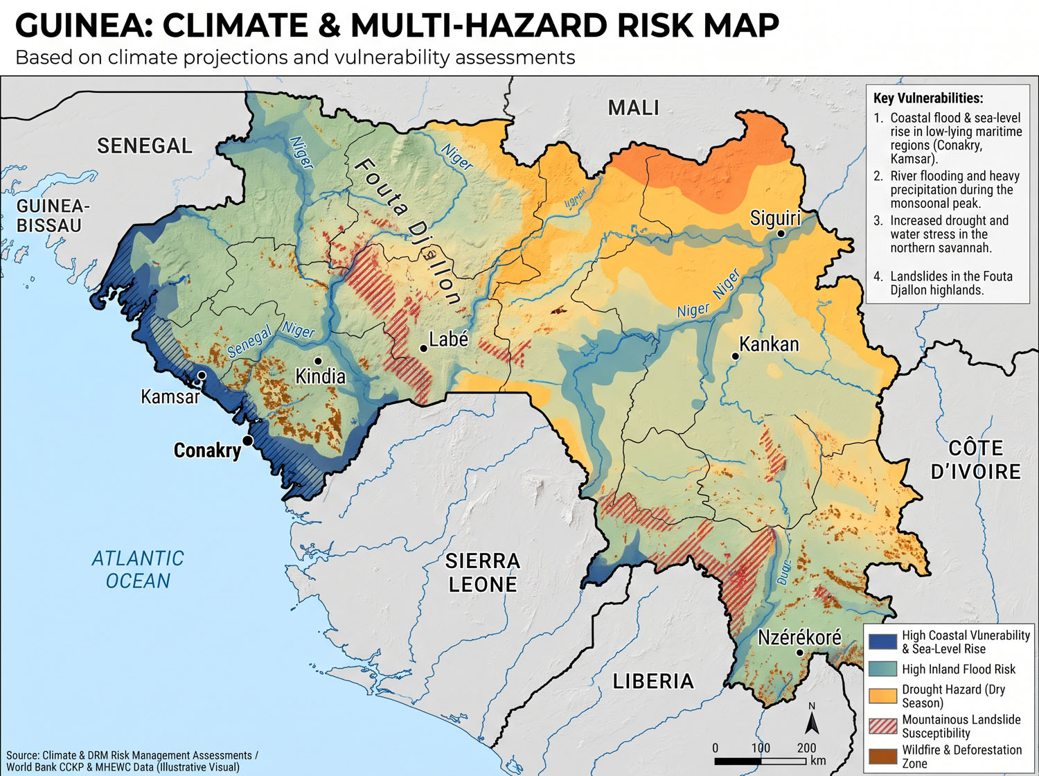
Guinea is highly exposed and vulnerable to climate change and multi-hazard risks due to its Atlantic coastline, flood-prone urban areas, coastal erosion, dependence on rainfed agriculture, pressure on forests and biodiversity, and reliance on climate-sensitive water resources. The country faces growing risks from floods, heavy rainfall, coastal flooding, sea-level rise, saltwater intrusion, droughts, landslides, forest fires, water-quality decline, agricultural losses, fisheries stress, and climate-sensitive disease outbreaks. Climate change is expected to intensify these vulnerabilities through rising temperatures, rainfall variability, extreme rainfall events, reduced river flows in some basins, salinization of coastal water sources, coastal rice-field loss, infrastructure degradation, food insecurity, and pressure on poor and natural-resource-dependent communities. Strengthening multi-hazard early warning systems, flood and coastal-risk management, climate-resilient agriculture, water-resource protection, ecosystem-based adaptation, resilient infrastructure, climate-health systems, disaster risk financing, and community-based preparedness is essential to reduce losses and protect Guinea’s development gains.
Guinea is vulnerable to climate change and multi-hazard risks due to its Atlantic coastal exposure, high rainfall variability, flood-prone urban and riverine areas, coastal erosion, sea-level rise, drought risk in northern and inland areas, dependence on rainfed agriculture, pressure on forests and biodiversity, and the strategic importance of water resources originating from the Fouta Djallon Highlands. Key risks include floods, coastal flooding, coastal erosion, sea-level rise, saltwater intrusion, droughts, heavy rainfall, landslides, forest fires, water-quality decline, agricultural losses, fisheries stress, and climate-sensitive health risks.
Guinea (Guinea-Conakry) Climate and Multi-Hazard Risk Profile
Updated 19 November 2026
Flooding is Guinea’s most recurrent disaster risk. The warning problem differs sharply between the coast and the interior. In Greater Conakry, intense rainfall can overwhelm drainage and inundate low-lying neighbourhoods within hours. In Upper Guinea, rising rivers can flood homes, farmland and road crossings across a much wider area. Heat and irregular rainfall threaten rain-fed agriculture and hydropower, while sea-level rise adds pressure on coastal settlements, mangrove rice fields and ports. The World Bank’s spatial assessment identifies about 7 million people living in climate-vulnerable areas, including roughly half a million in high-risk hotspots. These are modeled estimates of vulnerability and risk. ifrc.org
Guinea covers 245,857 km² and had 17.52 million residents in the preliminary results of its July 2025 census. Its four natural regions range from the Atlantic coastal plain and the Fouta Djallon highlands to the Upper Niger basin and the forested south and southeast. The Guinean highlands contain headwaters and upper catchments of the Niger, Senegal and Gambia rivers, so land degradation, changing flows and water management have consequences beyond Guinea’s borders. mesrs.gov.gn
Climate and projected change
| Climate factor | Implications for Guinea |
|---|---|
| Rainfall and seasonality | The main rainy season generally runs from May to October, with rainfall peaking in July and August in much of the country. The national agroecological atlas reports about 1,000 mm annually in the north and more than 3,000 mm along the coast. Guinea’s 2026 national SDG review cites a mean of roughly 3,800 mm per year for Conakry, based on national meteorological data. The north has a shorter rainy season, while the forested southeast remains wet for longer. zaeg.anasa.gov.gn |
| Temperature and heat | The World Bank’s two scenarios show national mean warming of about 0.9°C to 1.5°C in 2041–2050 relative to 1995–2020. Northern and northwestern areas are projected to experience some of the strongest warming. Guinea’s meteorological agency issued a national heatwave alert for 4–18 November 2026, following unusually warm days and nights across several regions. documents1.worldbank.org |
| Future rainfall | For 2041–2050, the World Bank models national average rainfall 6% below the historical reference in its hot, dry scenario and 13.1% above it in its warmer, wetter scenario. Seasonal planning needs to account for delayed onset, dry spells within the rainy season and intense downpours. Each has different implications for planting, reservoir inflows and drainage. documents1.worldbank.org |
| Sea-level rise | Higher coastal water levels increase the reach of tidal and storm inundation, accelerate erosion in exposed locations and allow saltwater to penetrate farther into estuaries and freshwater sources. The World Bank identifies Conakry, Boké and Forécariah among the areas most affected by projected changes in storm surge and sea level. documents1.worldbank.org |
Main hazards and consequences
| Hazard | How losses occur |
|---|---|
| River flooding | High flows in the Upper Niger and its tributaries inundate settlements, rice fields and roads. In Kankan, the Milo River has a broad floodplain that exposes riverside neighbourhoods, while intense rainfall can also flood the city centre. Flooded wells and damaged road access can prolong impacts after water levels fall. documents1.worldbank.org |
| Urban and flash flooding | Short, intense rainfall can exceed the capacity of drains and culverts in Greater Conakry and other growing towns. Development along drainage paths, waste accumulation and inadequate sanitation increase losses. Within Conakry, exposure is concentrated along watercourses, low-lying neighbourhoods and coastal drainage outlets. documents1.worldbank.org |
| Coastal inundation, erosion and salinity | High tides, storm water levels and waves threaten fishing settlements, roads and port infrastructure. Salinity places pressure on freshwater supplies and lowland agriculture. Mangrove degradation weakens natural protection and affects fisheries that depend on estuarine habitats. documents1.worldbank.org |
| Drought, dry spells and extreme heat | Late rains and dry spells affect planting, crop establishment, pasture and water supply. Heat adds stress for outdoor workers, increases crop water demand and can raise electricity demand. Water scarcity becomes more disruptive when low reservoir inflows reduce hydropower output. unfccc.int |
| Landslides, rockfall and erosion | Heavy rain can destabilize steep slopes, road cuts and disturbed ground. Manéah in Coyah demonstrates the risk to housing at the foot of steep slopes. Erosion also affects water supply: sediment from degraded upstream land enters reservoirs in the Samou sub-basin, which supplies Conakry. Anguch |
| Bushfires, severe thunderstorms and lightning | Dry-season fires threaten farms, pasture and forest margins. In the rainy season, thunderstorms combine lightning, strong winds and intense rain, exposing agricultural workers, fishers and settlements with limited shelter. These hazards require seasonal preparedness alongside flood planning. medd.gov.gn |
| Public-health emergencies | Floodwater can contaminate wells and latrines, damage health facilities and interrupt access to care. Health preparedness also covers malaria, heat-related illness and epidemic response. WHO documented a separate 2021 Ebola outbreak in Nzérékoré, which demonstrates the need for epidemic surveillance and response alongside climate-related health preparedness. UNICEF |
| Earthquakes and industrial emergencies | The 1983 magnitude 6.3 earthquake near Gaoual demonstrates the potential for damaging shaking in northwestern Guinea. Industrial risks include urban fuel-storage incidents and mine collapses. Heavy rainfall can also worsen erosion and contaminated runoff from poorly managed mining sites. 1983 |
Geographic risk priorities
These are screening priorities for prefectural and municipal assessment. Local surveys should confirm which settlements, crossings, clinics, schools and water facilities lie within each hazard zone.
| Natural region | Priority locations and exposures |
|---|---|
| Lower Guinea / Basse Guinée | Greater Conakry, Coyah and Dubréka for urban runoff, blocked drainage, settlement expansion and slope instability. Boké–Kamsar, Boffa and Forécariah for coastal flooding, saline intrusion and risks to ports, fisheries, mangrove agriculture and transport. Kindia also warrants assessment of urban flood paths and road access. pour chaque enfant |
| Middle Guinea / Moyenne Guinée | The Fouta Djallon highlands, including areas around Labé, Pita, Dalaba and Mamou, require attention to catchment degradation, erosion, slope stability and dry-season water availability. Headwater protection supports farms and communities locally and helps sustain downstream flows. zaeg.anasa.gov.gn |
| Upper Guinea / Haute Guinée | Kankan, Kouroussa, Siguiri and Mandiana face river flooding, crop losses and road isolation. The Faranah–Kankan agricultural belt also faces heat and rainfall variability. Siguiri combines floodplain exposure, dependence on climate-sensitive livelihoods and risks associated with mining. pour chaque enfant |
| Forest Guinea / Guinée Forestière | Nzérékoré, Guéckédou, Macenta and surrounding forested catchments face heavy-rain flooding, slope failure and disruption to rural roads. Flood preparedness should prioritize safe water, crossings and access to clinics and schools in communities that can become isolated. zaeg.anasa.gov.gn |
What past disasters show
- December 2023, Kaloum fuel-terminal explosion. The World Bank recorded 25 deaths and 457 injuries, widespread temporary fuel shortages and damage to nearby homes and businesses. The explosion also severely damaged the national meteorological agency’s premises, making continuity of forecasting and warning issuance part of the emergency. documents1.worldbank.org
- August–September 2024, widespread floods. An ANGUCH assessment reproduced by UNICEF recorded 133,688 people affected, 887 water points damaged and more than 11,000 hectares of farmland inundated for the reporting period 24 August–13 September. Impacts extended from Conakry and Coyah to Kankan, Siguiri, Mandiana and other prefectures. pour chaque enfant
- August 2025, Manéah landslide. A slope failure followed heavy rains on the night of 20–21 August in Coyah Prefecture and buried homes. The reported death toll rose to 19, underscoring the importance of mapping runout zones as well as unstable slopes. Anguch
- September 2026, floods across several regions. The national meteorological agency issued high flood-risk warnings for the coast and other regions. The Global Disaster Alert and Coordination System recorded impacts around Coyah and Manéah and separately reported that the Tilé River overflowed at Nzérékoré. anmeteo.gov.gn
Water and electricity are a major link between climate hazards and economic losses. During a hot, dry period, lower river flows can reduce hydropower generation while heat raises demand and reduces outdoor labour productivity. World Bank modeling places Guinea’s 2050 real GDP about 2.5% below baseline in its wetter, warmer scenario and up to 11.6% below baseline in its hotter, drier scenario without accelerated adaptation. Reduced hydropower generation is the largest modeled contributor in the hotter, drier case. At household level, service interruptions are harder to absorb where families rely on rain-fed agriculture, informal income or water points that flood, and where people need assistance receiving alerts or evacuating. documents1.worldbank.org
Disaster governance and early warning priorities
Guinea’s policy framework includes the 2026 National Adaptation Plan, NDC 3.0 for 2026–2035 and the National Disaster Risk Reduction Strategy 2024–2030. The National Meteorological Agency (ANM) issues weather warnings in the Common Alerting Protocol format, and the National Directorate of Hydraulics (DNH) has a national centre for flood and low-flow forecasting. ANGUCH coordinates preparedness and humanitarian response. The CLIMAGUI project, launched in October 2025, supports observation, forecasting and service upgrades. In July 2026, ANGUCH and the World Bank held a technical mission to operationalize contingent emergency financing for eligible crises. UNFCCC
| Proposed priority | Forecast or monitoring inputs and corresponding early action |
|---|---|
| Greater Conakry urban flood and landslide pilot | Combine short-duration rainfall forecasts, local gauges, drainage and slope maps, and tide levels at coastal outlets. Use past flood and landslide records to test neighbourhood-specific thresholds. Link warnings to road closures, evacuation assistance and protection of exposed water points. documents1.worldbank.org |
| Upper Niger river-flood pilot | Start with the Milo at Kankan and the Niger around Kouroussa and Siguiri. Combine upstream rainfall and river-level observations with floodplain maps. Agree on river stages that trigger alerts, protection of wells and health facilities, and relocation of livestock or stored crops. Share upstream observations with the Niger Basin Authority. documents1.worldbank.org |
| Drought and heat early action | Track rainfall onset, consecutive dry days, soil moisture, crop and pasture conditions, reservoir inflows and heat forecasts. Translate these into planting advice, water and power contingency planning, and heat protocols for health services and outdoor workers. unfccc.int |
| Coastal and marine preparedness | Connect tide, wave and wind forecasts to decisions for artisanal fishing, port operations and low-lying roads. Use local elevation and salinity information for longer-term planning in coastal settlements and agricultural areas. Test alert delivery through local-language radio, mobile messages and community networks. documents1.worldbank.org |
The practical test is whether a warning reaches the people responsible for action while there is still time to act. For each pilot, record when the warning was issued and received, which protective actions were taken, and which communities the message missed. Use those records to refine thresholds and improve access for older people, persons with disabilities and households with limited connectivity. pour chaque enfant
Working data sources include the ANM warning archive, ANGUCH incident updates, Guinea’s Agroecological Zoning Atlas, the National Adaptation Plan, and the World Bank Climate Change Knowledge Portal.


1. Multi-hazard exposure
Guinea’s risk profile is dominated by hydrometeorological, coastal, environmental, and public-health hazards. The country experiences a long rainy season across much of its territory, with annual rainfall varying significantly between coastal, highland, forest, and savannah zones. Climate projections indicate increasing temperatures, increased rainy-season rainfall, more heavy rainfall events, higher drought risk from rising temperatures and rainfall variability, and sea-level rise of 0.4 m to 0.7 m by 2100. (ClimaHealth)
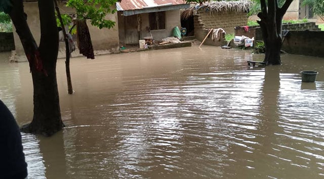
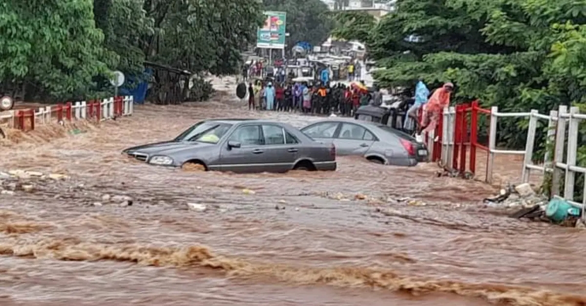
Flooding is a major concern, especially in urban areas such as Conakry, where intense rainfall, blocked drainage, informal settlement expansion, poor solid-waste management, and construction in flood-prone zones can increase loss of life, property damage, sanitation risks, and infrastructure disruption. Coastal flood hazard in Guinea is classified as high, meaning potentially damaging coastal flooding is expected at least once in the next 10 years in exposed coastal areas. (Think Hazard)

2. Climate change as a development risk multiplier
Climate change is a direct development risk for Guinea. The World Bank’s Guinea Country Climate and Development Report estimates that climate change could reduce Guinea’s GDP by 11.6% by 2050, with disproportionate impacts on poor households. It also notes that adaptation measures could reduce the negative impact by about half, lowering the estimated impact to 5.4% of baseline GDP in 2050. (Open Knowledge Repository)
The same report identifies major climate impacts on hydropower generation, agriculture, and infrastructure. Hydropower output is expected to become more variable by the 2040s, crop yields are expected to be significantly affected, and infrastructure is likely to be degraded by more volatile precipitation, flooding, and sea-level rise. (Open Knowledge Repository)
3. Coastal vulnerability
Guinea’s coastal zone is highly vulnerable to sea-level rise, coastal flooding, coastal erosion, saltwater intrusion, mangrove degradation, and damage to coastal livelihoods. About 6% of Guinea’s population lives in low-lying areas exposed to sea-level rise, while increased salinization and coastal flooding threaten agriculture, water availability, coastal infrastructure, and mangrove ecosystems. (ClimaHealth)
UNDP notes that climate change in Guinea’s coastal zone is expected to affect coastal economic development, coastal natural resources, coastal agricultural production, and food security. It identifies key long-term risks as rising sea level and saltwater intrusion, increased rainfall variability with more short and intense rain events, and more frequent drought periods in the northern part of the coastal zone. (UNDP Adaptation)
4. Water-resource vulnerability
Guinea is hydrologically important for West Africa because its highlands are home to the headwaters of major regional rivers, including the Gambia, Niger, and Senegal. Although Guinea has abundant renewable water resources, warming temperatures, changing rainfall, drought risk, heavy rainfall, erosion, mining pollution, agricultural runoff, and sea-level rise threaten water quantity and quality. (ClimaHealth)
Projected reductions in river flows are a major concern. Climate-risk analysis indicates that reduced rainfall and warming could reduce flows in the Konkouré River by 30–50% by 2100, affecting hydropower, while northern rivers such as the Milo could see flow reductions of up to 70% by 2100. These risks matter because water systems support drinking water, irrigation, hydropower, fisheries, ecosystems, and mining-related economic activity. (ClimaHealth)
5. Agriculture and food-security vulnerability
Agriculture is highly climate-sensitive in Guinea because 97% of cultivation is rainfed. The sector contributes significantly to livelihoods and food security, but it is exposed to irregular rainfall, droughts, heavy rainfall, pests, crop diseases, salinity intrusion, flooding, and shifting growing seasons. (ClimaHealth)
Climate projections suggest that maize yields could decline by 5–25% by 2050, with losses potentially exceeding 25% in southern border areas such as N’Zérékoré and Kankan. Sea-level rise could also cause a major loss of 17–30% of coastal rice fields by 2050 through salinization, erosion, and flooding. (ClimaHealth)
6. Forests, biodiversity, and ecosystem vulnerability
Guinea’s forests, mangroves, river systems, wetlands, and biodiversity provide important ecosystem services, including water regulation, soil protection, coastal protection, fisheries support, livelihoods, and carbon storage. However, these systems are threatened by climate change, agricultural expansion, mining, logging, forest degradation, wildfire risk, and increasing pressure on natural resources. Climate-risk analysis identifies reduced forest productivity, declining ecosystem services, increased fire risk, and species distribution shifts as key forest and biodiversity risks. (ClimaHealth)
7. Health and social vulnerability
Climate change can worsen public-health risks in Guinea through flooding, poor sanitation, contaminated water, heat stress, vector-borne diseases, diarrheal disease, and zoonotic disease risks. The climate-risk profile highlights increased risk of diarrheal disease, possible expansion of malaria risk to higher elevations, and increased risks linked to changes in rainfall, temperature, human-wildlife contact, and food insecurity. (ClimaHealth)
The most vulnerable groups include poor urban households, informal settlers, coastal communities, smallholder farmers, fishing communities, women-headed households, children, older persons, people with disabilities, forest-dependent communities, and households living in flood-prone, erosion-prone, drought-prone, or low-lying coastal areas.
Sector-specific vulnerability summary
| Sector | Main climate and hazard risks |
|---|---|
| Agriculture and food security | Rainfall variability, drought, flooding, crop pests, salinity, rice-field loss, maize-yield decline |
| Water resources | Reduced river flows, water-quality decline, sedimentation, saltwater intrusion, hydropower variability |
| Coastal zones | Sea-level rise, coastal flooding, erosion, mangrove loss, saltwater intrusion, infrastructure damage |
| Urban settlements | Flash flooding, poor drainage, sanitation risks, informal settlement exposure, infrastructure disruption |
| Fisheries | Ocean warming, mangrove degradation, coastal pollution, reduced productivity, livelihood losses |
| Forests and biodiversity | Forest degradation, wildfire risk, reduced ecosystem services, habitat loss, species shifts |
| Health | Diarrheal disease, malaria-range shifts, water contamination, heat stress, zoonotic disease risks |
| Infrastructure and mining areas | Flood damage, erosion, road disruption, sedimentation, water pollution, service interruption |
Priority resilience needs
Guinea’s resilience agenda should prioritize multi-hazard early warning systems, urban flood-risk management, coastal-zone protection, sea-level-rise monitoring, mangrove restoration, saltwater-intrusion management, climate-smart agriculture, drought monitoring, hydrological forecasting, water-quality protection, resilient infrastructure, forest and biodiversity conservation, climate-health surveillance, disaster risk financing, and locally led adaptation.

NATIONAL AGENCY FOR EMERGENCY AND HUMANITARIAN DISASTER MANAGEMENT https://anguch.gov.gn
The National Agency for Emergency and Humanitarian Disaster Management, abbreviated as ANGUCH, is a Public Establishment of an Administrative Nature (EPA) created by decree D/2022/0320/PRG/SGG of June 23, 2022.
The Director General of the National Agency for Emergency and Humanitarian Disaster Management (ANGUCH), Lancei Touré, gave an exclusive interview to IMEDIAS to highlight the disaster management strategy in the country as well as the challenges faced by the agency.
Established two years ago, ANGUCH was created with the aim of strengthening the capacity to respond to natural disasters and humanitarian crises in Guinea. Since its creation, the Agency has quickly become a key pillar of civil protection. It has demonstrated its effectiveness in critical situations such as the recurring floods during the rainy season and the rapid intervention following the explosion at the Kaloum oil depot.
During the interview, Lancei Touré shared the numerous challenges ANGUCH has faced since its creation. One of the main challenges remains strengthening coordination between the various sectors and technical and financial partners involved in emergency management. This coordination is crucial to ensuring a rapid and effective response to disasters.
ANGUCH does not simply respond to disasters; it also plays a key role in prevention and post-crisis recovery. The agency actively works to develop emergency preparedness plans and implement preventative measures to reduce disaster risks.
Despite the challenges, Lancei Touré expressed an optimistic vision for the future of ANGUCH. The agency plans to strengthen its capacities and develop new partnerships to improve community resilience to disasters. Continued efforts to improve coordination and preparedness will enable ANGUCH to continue effectively protecting the Guinean population from future crises.

Vision
Coordinate and monitor all humanitarian emergency and disaster management activities.
Value Prevent – Assess – Assist – Restore
Main areas of intervention
- The COORDINATION
ANGUCH coordinates emergency humanitarian operations
- COPIAS (Standing Inter-Agency Strategic Committee)
- COPIAT (permanent inter-agency technical committee)
- Developing a VCA (Vulnerability and Capability Analysis)
- The development of an Emergency Response Plan (ERP)
- State structures involved in emergency and disaster management.
IN THE PREFECTURES:
- In the Administrative Regions, the Regional Coordinators of the Agency (CRA) and in the Prefectures, the Prefectural Coordinators of the Agency (CPA) must preside over the meetings of state and non-state partners involved in the management of emergencies and humanitarian disasters.
- Similarly, in urban municipalities, the municipal coordinators (CCA) must chair the meetings of the partners mentioned above.
- They coordinate all humanitarian activities at the deconcentrated and decentralized level.
- HUMANITARIAN AID
ANGUCH assists people affected by natural and man-made disasters throughout the national territory in partnership with all actors involved in emergency and disaster management.
- The Partnership
ANGUCH establishes partnerships with all actors involved in the management of humanitarian emergencies and disasters throughout the national territory.
- DISPLACEMENT MANAGEMENT (returning migrants, internally displaced persons and refugees)
ANGUCH is responsible for managing migrants returning to the country through:
| Steps | Officials |
| Reception of migrants | AE/ANGUCH/IOM / Social Action |
| Transport to the transit site | ANGUCH |
| Profiling and restoration | IOM/ANGUCH |
| Return to the Prefectures of Origin | IOM/ANGUCH |
| Socio-professional reintegration | IOM/ANGUCH (CPA) |
| Monitoring in the prefectures | IOM/CPA |
| Central Technical UnitRegional technical unitsLocal Monitoring Committee | IOM (Conakry) (monthly)Chaired by the Governors (monthly)Chaired by the SGC (monthly) |
Missions and Responsibilities of the Ministry
The Ministry of Security and Civil Protection is responsible for designing, developing, implementing, and monitoring government policy in the areas of security and civil protection.
In this respect, he is particularly burdened:
To participate in national, sub-regional, regional and international meetings dealing with policing and civil protection issues
Drafting legislative and regulatory texts relating to the fields of security and civil protection
Drafting legislative and regulatory texts relating to the establishment and operation of the system for managing police and civil protection personnel and services
To ensure the safety of people and property
To organize and ensure the maintenance and restoration of public order
To coordinate and strengthen the fight against domestic and transnational crime
To participate in the fight against the proliferation and illicit circulation of small arms
To inform the Government in the political, economic, social and cultural fields
To ensure the control of the movement of people across national borders
To ensure the control of entry and stay of foreigners on national territory
To contribute to the prevention and fight against terrorism and subversive activities
To ensure the protection of high-ranking officials and vital installations
To define the standards, methods and modes of intervention of the police forces for security operations
To develop preventive and emergency measures in the event of disasters of any kind and to manage major events
To coordinate all intervention and rescue operations in the context of fighting fires, accidents, disasters and catastrophes
To ensure the application of the code of ethics for the police and civil protection
To develop strategies and programs for the training and professional development of police and civil protection personnel
To maintain and develop cooperative relations with sub-regional, regional and international institutions in the areas of security and civil protection
To promote gender equality and equity in sector activities
To take into account the environmental dimension in the programs and projects of the sector
To promote the development of arts and sports within the police and civil protection services
To promote the teaching of human rights and international humanitarian law to police and civil protection personnel
To participate in the fight against serious crime, organized crime and delinquency
To participate in the fight against economic and financial crime
To participate in the fight against cybercrime
To participate in the drafting of legislative and regulatory texts relating to the protection of women, children and morals, and to ensure their application
To ensure the implementation of conventions, protocols and agreements protecting women, children and morals
To participate in peacekeeping and law enforcement operations on behalf of the United Nations
To participate in the mobilization of resources necessary for strengthening the capacities of police and civil protection services
Download Documents on Guinea
https://drive.google.com/drive/folders/1TBRQAAdKQ5ztfbpbH7XFkYPoeIj8-1H1?usp=drive_link
